Filters: Tags: deepwater horizon (X)
53 results (78ms)|
Filters
Date Range
Contacts Tag Schemes |
A 75,000 x 75,000 meter grid covering the Gulf of Mexico, created to identify possible areas of landfall of oil from the Deepwater Horizon oil spill. Using oil spill trajectories produced by the Ocean Circulation Group and the Optical Oceanography Laboratory at the College of Marine Science, University of South Florida, and protected areas data catalogued in PAD-US (CBI Edition) , we provide a preliminary attempt to identify ecological resources that may be affected by the spill. By overlaying these projected trajectories on a standardized grid, we can select areas that may contain oil from the spill, or are likely to contain oil in the future. We then identify protected areas that are likely to be most directly...

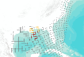
Roughly digitized version of the Deepwater Horizon oil spill trajectory ensemble forecast from different numerical models, a joint effort of the Ocean Circulation Group and the Optical Oceanography Laboratory at College of Marine Science, University of South Florida to track/predict the Deepwater Horizon oil spill in the Gulf of Mexico using simulated drifters/particles. More information on the projections can be found here (last checked 07/14/2010): http://ocg6.marine.usf.edu/~liu/oil_spill_ensemble_forecast.html This shapefile represents WFSROMS model output for particles for July 15, 2010 at 00 hour UTC, as reported on July 13, 2010.

This dataset is extracted from PAD-US 1.1 (CBI Edition), and the original metadata has been included here, below. These protected areas were roughly identified by the Conservation Biology Institute as being secondarily threatened by the Deepwater Horizon oil spill in the Gulf of Mexico. The probability of being affected was determined using the University of South Florida's Deepwater Horizon oil spill trajectory forecast from the WFS ROMS numerical model, as projected for 06/11/2010 at 00h UTC (http://ocg6.marine.usf.edu/~liu/oil_spill_ensemble_forecast.html). For more information, please see the Oil Spill in the Gulf of Mexico page at Data Basin (http://www.databasin.org/aquatic-center/features/oil-spill or http://www.databasin.org)....

Roughly digitized version of the Deepwater Horizon oil spill trajectory ensemble forecast from different numerical models, a joint effort of the Ocean Circulation Group and the Optical Oceanography Laboratory at College of Marine Science, University of South Florida to track/predict the Deepwater Horizon oil spill in the Gulf of Mexico using simulated drifters/particles. More information on the projections can be found here (last checked 07/11/2010): http://ocg6.marine.usf.edu/~liu/oil_spill_ensemble_forecast.html This shapefile represents WFSROMS model output for particles for July 11, 2010 at 00 hour UTC, as reported on July 8, 2010.

Roughly digitized version of the Deepwater Horizon oil spill trajectory ensemble forecast from different numerical models, a joint effort of the Ocean Circulation Group and the Optical Oceanography Laboratory at College of Marine Science, University of South Florida to track/predict the Deepwater Horizon oil spill in the Gulf of Mexico using simulated drifters/particles. More information on the projections can be found here (last checked 06/29/2010): http://ocg6.marine.usf.edu/~liu/oil_spill_ensemble_forecast.html This shapefile represents WFSROMS model output for particles for July 2, 2010 at 00 hour UTC, as reported on June 29, 2010.
These protected areas were estimated by the Conservation Biology Institute as being secondarily threatened by the corresponding Deepwater Horizon oil spill trajectory forecast in the Gulf of Mexico. This dataset is extracted from PAD-US 1.1 (CBI Edition), and the original metadata has been included here, below. First, protected areas within 1 mile of the entire study area coastline (TX to NJ), or that intersect hydrological feature polygons from the NHDPlus National Hydrography Dataset within the 1-mile coastline buffer, were extracted from PAD-US 1.1 (CBI Edition). Then, protected areas were identified as being under primary, secondary, or tertiary threat from the oil spill. The probability of being affected...

This dataset is extracted from PAD-US 1.1 (CBI Edition), and the original metadata has been included here, below. These protected areas were roughly identified by the Conservation Biology Institute as being Secondarily threatened by the Deepwater Horizon oil spill in the Gulf of Mexico. The probability of being affected was determined using the University of South Florida's Deepwater Horizon oil spill trajectory forecast from the WFS ROMS numerical model, as projected for 06/11/2010 at 00h UTC (http://ocg6.marine.usf.edu/~liu/oil_spill_ensemble_forecast.html ). For more information, please see the Oil Spill in the Gulf of Mexico page at Data Basin (http://www.databasin.org/aquatic-center/features/oil-spill or...

Roughly digitized version of the Deepwater Horizon oil spill trajectory ensemble forecast from different numerical models, a joint effort of the Ocean Circulation Group and the Optical Oceanography Laboratory at College of Marine Science, University of South Florida to track/predict the Deepwater Horizon oil spill in the Gulf of Mexico using simulated drifters/particles. More information on the projections can be found here (last checked 06/08/2010): http://ocg6.marine.usf.edu/~liu/oil_spill_ensemble_forecast.html This shapefile represents WFSROMS model output for particles for June 11, 2010 at 00 hour UTC, as reported on May 31, 2010.

This dataset is extracted from PAD-US 1.1 (CBI Edition), and the original metadata has been included here. These protected areas were roughly identified by the Conservation Biology Institute as being the "most immediately" threatened by the Deepwater Horizon oil spill in the Gulf of Mexico. The probability of being affected was determined using the University of South Florida's Deepwater Horizon oil spill trajectory forecast from the WFS ROMS numerical model, as projected for 06/03/2010 at 00h UTC (http://ocg6.marine.usf.edu/~liu/oil_spill_ensemble_forecast.html). For more information, please see the Oil Spill in the Gulf of Mexico page at Data Basin (http://www.databasin.org/aquatic-center/features/oil-spill...

This dataset is extracted from PAD-US 1.1 (CBI Edition), and the original metadata has been included here. These protected areas were identified by the Conservation Biology Institute as being secondarily threatened by the Deepwater Horizon oil spill in the Gulf of Mexico if trajectory projections continue on their current course, as given by trajectory projections for 05/28/2010. For more information, please see the Oil Spill in the Gulf of Mexico page at Data Basin (http://www.databasin.org/aquatic-center/features/oil-spill or http://www.databasin.org). Original metadata abstract: Protected areas are cornerstones of national and international conservation strategies. By way of these designations, lands and...

These protected areas were estimated by the Conservation Biology Institute as being most immediately threatened by the corresponding Deepwater Horizon oil spill trajectory forecast in the Gulf of Mexico. This dataset is extracted from PAD-US 1.1 (CBI Edition), and the original metadata has been included here, below. First, protected areas within 1 mile of the entire study area coastline (TX to NJ), or that intersect hydrological feature polygons from the NHDPlus National Hydrography Dataset within the 1-mile coastline buffer, were extracted from PAD-US 1.1 (CBI Edition). Then, protected areas were identified as being under primary, secondary, or tertiary threat from the oil spill. The probability of being affected...

Roughly digitized version of the Deepwater Horizon oil spill trajectory ensemble forecast from different numerical models, a joint effort of the Ocean Circulation Group and the Optical Oceanography Laboratory at College of Marine Science, University of South Florida to track/predict the Deepwater Horizon oil spill in the Gulf of Mexico using simulated drifters/particles. More information on the projections can be found here (last checked 07/18/2010): http://ocg6.marine.usf.edu/~liu/oil_spill_ensemble_forecast.html This shapefile represents WFSROMS model output for particles for July 18, 2010 at 00 hour UTC, as reported on July 16, 2010.

This dataset is extracted from PAD-US 1.1 (CBI Edition), and the original metadata has been included here, below. These protected areas were roughly identified by the Conservation Biology Institute as being the most immediately threatened by the Deepwater Horizon oil spill in the Gulf of Mexico. The probability of being affected was determined using the University of South Florida's Deepwater Horizon oil spill trajectory forecast from the WFS ROMS numerical model, as projected for 06/11/2010 at 00h UTC (http://ocg6.marine.usf.edu/~liu/oil_spill_ensemble_forecast.html). For more information, please see the Oil Spill in the Gulf of Mexico page at Data Basin (http://www.databasin.org/aquatic-center/features/oil-spill...

This dataset is extracted from PAD-US 1.1 (CBI Edition), and the original metadata has been included here. These protected areas were roughly identified by the Conservation Biology Institute as being the "most immediately" threatened by the Deepwater Horizon oil spill in the Gulf of Mexico. The probability of being affected was determined using the University of South Florida's Deepwater Horizon oil spill trajectory forecast from the WFS ROMS numerical model, as projected for 05/31/2010 at 00h UTC (http://ocg6.marine.usf.edu/~liu/oil_spill_ensemble_forecast.html). For more information, please see the Oil Spill in the Gulf of Mexico page at Data Basin (http://www.databasin.org/aquatic-center/features/oil-spill...

Roughly digitized version of the Deepwater Horizon oil spill trajectory ensemble forecast from different numerical models, a joint effort of the Ocean Circulation Group and the Optical Oceanography Laboratory at College of Marine Science, University of South Florida to track/predict the Deepwater Horizon oil spill in the Gulf of Mexico using simulated drifters/particles. More information on the projections can be found here (last checked 06/18/2010): http://ocg6.marine.usf.edu/~liu/oil_spill_ensemble_forecast.html This shapefile represents WFSROMS model output for particles for June 18, 2010 at 00 hour UTC, as reported on June 15, 2010.

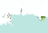
This dataset gives a rough approximation of where oil from the BP Deepwater Horizon oil spill has made landfall along the Gulf Coast, with the most recent projections added for July 16, 2010. This data is intended only to give a general idea of the scope of the the oil spill, and not to make specific or detailed analyses of oil spill landfall.

These protected areas were estimated by the Conservation Biology Institute as being most immediately threatened by the corresponding Deepwater Horizon oil spill trajectory forecast in the Gulf of Mexico. This dataset is extracted from PAD-US 1.1 (CBI Edition), and the original metadata has been included here, below. First, protected areas within 1 mile of the entire study area coastline (TX to NJ), or that intersect hydrological feature polygons from the NHDPlus National Hydrography Dataset within the 1-mile coastline buffer, were extracted from PAD-US 1.1 (CBI Edition). Then, protected areas were identified as being under primary, secondary, or tertiary threat from the oil spill. The probability of being affected...

The dataset represents hydrological features, extracted from the NHDPlus NHDWaterbody shapefile, that intersect a 1 mile interior coastline buffer along the Gulf of Mexico and Atlantic Ocean coasts within our study area, from Texas to New Jersey. The NHDPlus NHDWaterbody shapefile describes NHD polygonal features of types: Playa, Ice Mass, LakePond, Reservoir, SwampMarsh, and Estuary. NHDPlus is a complex, nationwide dataset features that can be accessed here (last checked 06/16/10): http://www.horizon-systems.com/nhdplus/ . Its original metadata is included below. The NHDPlus Version 1.0 is an integrated suite of application-ready geospatial data sets that incorporate many of the best features of the National...

These protected areas were estimated by the Conservation Biology Institute as being most immediately threatened by the corresponding Deepwater Horizon oil spill trajectory forecast in the Gulf of Mexico. This dataset is extracted from PAD-US 1.1 (CBI Edition), and the original metadata has been included here, below. First, protected areas within 1 mile of the entire study area coastline (TX to NJ), or that intersect hydrological feature polygons from the NHDPlus National Hydrography Dataset within the 1-mile coastline buffer, were extracted from PAD-US 1.1 (CBI Edition). Then, protected areas were identified as being under primary, secondary, or tertiary threat from the oil spill. The probability of being affected...

These protected areas were estimated by the Conservation Biology Institute as being secondarily threatened by the corresponding Deepwater Horizon oil spill trajectory forecast in the Gulf of Mexico. This dataset is extracted from PAD-US 1.1 (CBI Edition), and the original metadata has been included here, below. First, protected areas within 1 mile of the entire study area coastline (TX to NJ), or that intersect hydrological feature polygons from the NHDPlus National Hydrography Dataset within the 1-mile coastline buffer, were extracted from PAD-US 1.1 (CBI Edition). Then, protected areas were identified as being under primary, secondary, or tertiary threat from the oil spill. The probability of being affected...
|

|
