Filters: Tags: domestic (X)
42 results (34ms)|
Filters
Contacts
(Less)
|
Long-term greenhouse gas emission reduction strategies for the Netherlands were studied, using a MARKAL energy model. The EMS study identifies longterm technological options for greenhouse gas emission reduction and assesses their cost-effectiveness, taking interactions between technologies into account. The project consisted of three parts: carbon dioxyde (CO 2) emission reduction in the energy system, integrated reduction of greenhouse gases from the energy system with consideration of upstream emissions and CO 2 reduction in the integrated energy and materials system. 500 energy technologies were assessed for their reduction potential. Significant emission reduction seems possible, but it takes an array of measures...
Categories: Publication;
Types: Citation;
Tags: Domestic,
Policy,
development,
energy,
energy policies
Evidence from cross-sectional growth regressions suggests that economies dependent on natural resource exports have had slower growth than resource scarce economies. Explanations for this "curse of resources" focus on institutional and market failures caused by resource abundance. With a simple two sector model exhaustible resource model, we demonstrate that the correlation between growth and natural resource abundance can be negative in the absence of market and institutional failures. Since there is no way to distinguish between efficient and inefficient equilibria on the basis of the negative correlation between growth and resource abundance, finding that correlation is not sufficient to conclude resources are...
Categories: Publication;
Types: Citation;
Tags: Hotelling's rule,
domestic,
oil,
production,
relevance
In 2015, the total amount of water withdrawn for recreational-landscape irrigation uses in Florida was estimated at 398 million gallons per day (Mgal/d). Withdrawals include water used for golf course and public and commercial landscape irrigation (parks, ball fields, highway medians, cemeteries, and other large-scale grass or landscaping areas) that have a consumptive water use permit from the local water management district specifically for golf course or landscape uses. This category does not include individual household lawn irrigation withdrawals. Fresh surface water accounted for 216 Mgal/d of the fresh water withdrawn while 182 Mgal/d was withdrawn from fresh groundwater sources. Palm Beach County accounted...

The SARP Flow Alteration Assessment provides a regional characterization of the distribution and risk of flow regime impairment of streams and rivers by anthropogenic sources at the NHD+ segment scale. This map illustrates the cumulative risk of flow alteration (RFA) from surface water use for thermopower generation in Oklahoma.  Water use is based on state permits for surface water withdrawals and returns.  The risk is based on the volume of water used monthly in the drainage area relative to the monthly volume of flow.  Risk of Flow Alteration categories:  ZERO     - 0% mean monthly flow depletion,  LOW      - > 0-10%,  MEDIUM - > 10-20%,  HIGH      - >20-100%, and  PROVISIONAL...
In 2015, the total amount of water withdrawn for public supply in Florida was estimated at 2,385 million gallons per day (Mgal/d). Water withdrawals include 2,215 Mgal/d of fresh water and 170 Mgal/d of saline water. Fresh groundwater accounted for 1,909 Mgal/d of the water withdrawn and 169 Mgal/d of the saline groundwater withdrawn for public supply. Miami-Dade County accounted for the largest amount of fresh groundwater withdrawn (339 Mgal/d), Hillsborough County accounted for the largest amount of fresh surface water withdrawn (135 Mgal/d) and all of the saline surface water withdrawn (1 Mgal/d), and Lee County accounted for the largest amount of saline groundwater withdrawn (28 Mgal/d). All of the saline water...

The SARP Flow Alteration Assessment provides a regional characterization of the distribution and risk of flow regime impairment of streams and rivers by anthropogenic sources at the NHD+ segment scale. This map illustrates the cumulative risk of flow alteration (RFA) from surface water use industrial water use in Texas and Oklahoma.  Water use is based on state permits for surface water withdrawals and returns.  The risk is based on the volume of water used monthly in the drainage area relative to the monthly volume of flow.  Risk of Flow Alteration categories:  ZERO     - 0% mean monthly flow depletion,  LOW      - > 0-10%,  MEDIUM - > 10-20%,  HIGH      - >20-100%, and Â...
This data set contains imagery from the National Agriculture Imagery Program (NAIP). The NAIP program is administered by USDA FSA and has been established to support two main FSA strategic goals centered on agricultural production. These are increase stewardship of America's natural resources while enhancing the environment, and to ensure commodities are procured and distributed effectively and efficiently to increase food security. The NAIP program supports these goals by acquiring and providing ortho imagery that has been collected during the agricultural growing season in the U.S. The NAIP ortho imagery is tailored to meet FSA requirements and is a fundamental tool used to support FSA farm and conservation programs....

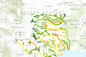
The SARP Flow Alteration Assessment provides a regional characterization of the distribution and risk of flow regime impairment of streams and rivers by anthropogenic sources at the NHD+ segment scale. This map illustrates the local risk of flow alteration (RFA) from surface water use by water use sector for Texas and Oklahoma.  Water use is based on state permits for surface water withdrawals and returns.  The risk is based on the volume of water used monthly in the drainage area relative to the monthly volume of flow.  Risk of Flow Alteration categories:  ZERO     - 0% mean monthly flow depletion,  LOW      - > 0-10%,  MEDIUM - > 10-20%,  HIGH      - >20-100%, and  PROVISIONAL...
The SARP Flow Alteration Assessment provides a regional characterization of the distribution and risk of flow regime impairment of streams and rivers by anthropogenic sources at the NHD+ segment scale. This map illustrates the cumulative risk of flow alteration (RFA) from surface water use for mining in Texas and Oklahoma.  Water use is based on state permits for surface water withdrawals and returns.  The risk is based on the volume of water used monthly in the drainage area relative to the monthly volume of flow.  Risk of Flow Alteration categories:  ZERO     - 0% mean monthly flow depletion,  LOW      - > 0-10%,  MEDIUM - > 10-20%,  HIGH      - >20-100%, and  PROVISIONAL...

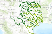
The SARP Flow Alteration Assessment provides a regional characterization of the distribution and risk of flow regime impairment of streams and rivers by anthropogenic sources at the NHD+ segment scale. This map illustrates the cumulative risk of flow alteration (RFA) from surface water use for domestic and livestock in Texas and Oklahoma.  Water use is based on state permits for surface water withdrawals and returns.  The risk is based on the volume of water used monthly in the drainage area relative to the monthly volume of flow.  Risk of Flow Alteration categories:  ZERO     - 0% mean monthly flow depletion,  LOW      - > 0-10%,  MEDIUM - > 10-20%,  HIGH      - >20-100%,...
Energy and mineral development, particularly coalbed natural gas development, is proceeding at a rapid pace in the Powder River Structural Basin (PRB) in northeastern Wyoming. Concerns about the potential effects of development led to formation of an interagency working group of primarily Federal and State agencies to address these issues in the PRB in Wyoming and in Montana where similar types of resources exist but are largely undeveloped. Under the direction of the interagency working group, an ecological assessment of streams in the PRB was initiated to determine the current status (2005-06) and to establish a baseline for future monitoring. The ecological assessment components include assessment of stream habitat...
Categories: Publication;
Types: Citation;
Tags: Domestic,
Policy,
development,
energy,
energy policies
The opportunities for long term energy efficiency improvement in industry have been studied. Three studies are described. The first study was directed at making a preliminary survey of technologies that might reduce the end-use demand of industrial processes on the long term. The second study focused on the development of a methodology to make a more profound analysis of the long term potential. The third study describes a database for energy efficient technologies. It is concluded that, after technologies that are currently technically feasible have been implemented, there still exists a considerable (new) potential for improvement.
Categories: Publication;
Types: Citation;
Tags: Domestic,
Policy,
development,
energy,
energy policies
Designed to provide insights into policies relative to human resource investments and employment information channels, the study's objectives were to: (1) relate types of employment in Wyoming's uranium mines and mills to work force participants; (2) determine employee earnings and relate those earnings to employment categories and characteristics; (3) examine employee tenure and turnover patterns; and (4) describe employment channels of information. Between December 1971 and June 1972, data were collected on 1,059 males via questionnaires administered to either the manager or personnel manager of each of 6 Wyoming uranium operations and via questionnaires taken to county Employment Security Commission offices in...
Categories: Publication;
Types: Citation;
Tags: Ireland,
Photovoltaic,
Projected costs,
domestic,
grid-connected,
A study using multiple techniques provided insight into tectonic influences on ground water systems; the results can help to understand ground water systems in the tectonically active western United States and other parts of the world. Ground water in the San Bernardino Valley (Arizona, United States and Sonora, Mexico) is the main source of water for domestic use, cattle ranching (the primary industry), and the preservation of threatened and endangered species. To improve the understanding of ground water occurrence, movement, and sustainability, an investigation was conducted using a number of complementary methods, including major ion geochemistry, isotope hydrology, analysis of gases dissolved in ground water,...
Categories: Publication;
Types: Citation,
Journal Citation;
Tags: Arizona,
Ground Water,
Mexico,
United States,
animals,
This data set contains imagery from the National Agriculture Imagery Program (NAIP). The NAIP program is administered by USDA FSA and has been established to support two main FSA strategic goals centered on agricultural production. These are increase stewardship of America's natural resources while enhancing the environment, and to ensure commodities are procured and distributed effectively and efficiently to increase food security. The NAIP program supports these goals by acquiring and providing ortho imagery that has been collected during the agricultural growing season in the U.S. The NAIP ortho imagery is tailored to meet FSA requirements and is a fundamental tool used to support FSA farm and conservation programs....
The SARP Flow Alteration Assessment provides a regional characterization of the distribution and risk of flow regime impairment of streams and rivers by anthropogenic sources at the NHD+ segment scale. This map illustrates the cumulative risk of flow alteration (RFA) from surface water use by water use sector for Texas and Oklahoma.  Water use is based on state permits for surface water withdrawals and returns.  The risk is based on the volume of water used monthly in the drainage area relative to the monthly volume of flow.Risk of Flow Alteration categories: ZERO     - 0% mean monthly flow depletion,  LOW      - > 0-10%,  MEDIUM - > 10-20%,  HIGH      - >20-100%, and PROVISIONAL...

The SARP Flow Alteration Assessment provides a regional characterization of the distribution and risk of flow regime impairment of streams and rivers by anthropogenic sources at the NHD+ segment scale. This map illustrates the cumulative risk of flow alteration (RFA) from surface water use for municipalities in Texas and Oklahoma.  Water use is based on state permits for surface water withdrawals and returns.  The risk is based on the volume of water used monthly in the drainage area relative to the monthly volume of flow.  Risk of Flow Alteration categories:  ZERO     - 0% mean monthly flow depletion,  LOW      - > 0-10%,  MEDIUM - > 10-20%,  HIGH      - >20-100%, and  PROVISIONAL...
Because of the inevitable depletion of fossil fuels and the corresponding release of carbon to the environment, the global energy future is complex. Some of the consequences may be politically and economically disruptive, and expensive to remedy. For the next several centuries, fuel requirements will increase with population, land use, and ecosystem degradation. Current or projected levels of aggregated energy resource use will not sustain civilization as we know it beyond a few more generations. At the same time, issues of energy security, reliability, sustainability, recoverability, and safety need attention. We supply a top-down, qualitative model—the surety model—to balance expenditures of limited resources...
Categories: Publication;
Types: Citation;
Tags: Transportation,
domestic,
emissions,
greenhouse gas,
trading
|

|
