Filters: Tags: drainage (X) > Types: Citation (X)
18 results (9ms)|
Filters
Date Range
Extensions Types
Contacts
Categories Tag Types
|

The USGS National Hydrography Dataset (NHD) service from The National Map (TNM) is a comprehensive set of digital spatial data that encodes information about naturally occurring and constructed bodies of surface water (lakes, ponds, and reservoirs), paths through which water flows (canals, ditches, streams, and rivers), and related entities such as point features (springs, wells, stream gages, and dams). The information encoded about these features includes classification and other characteristics, delineation, geographic name, position and related measures, a "reach code" through which other information can be related to the NHD, and the direction of water flow. The network of reach codes delineating water and...
This dataset is the output of a python script/ArcGIS model that identifes dikes as having a difference in elevation above a certain threshold. If the elevation difference was below a certain threshold the area was not considered a dike; however, if the difference in elevation between two points was significantly high then the area was marked as a dike. Areas continuous with eachother were considered part of the same dike. Post processing occured. Users examined the data output, comparing the proposed dike locations to aerial imagery, flowline data, and the DEM. Dikes that appeared to be false positives were deleted from the data set.
Categories: Data;
Types: Citation,
Downloadable,
Map Service,
OGC WFS Layer,
OGC WMS Layer,
Shapefile;
Tags: Great Lakes,
LIDAR,
Lake Erie,
biogeography,
coastal ecosystems,
Sediment erosion and deposition in two sets of paired (treated and untreated) upland drainages in the Torreon Wash watershed, upper Rio Puerco Basin, New Mexico, were examined over a 3 1/2-year period from spring 2009 through fall 2012. The objective was to evaluate the effectiveness of shallow, loose-stone check dams, or “one-rock dams,” as a hillslope gully erosion stabilization and mitigation method, and its potential for retaining upland eroded soils and decreasing delivery of sediment to lower ephemeral stream channels. Two high-resolution topographic surveys, completed at the beginning and end of the study period, were used to assess the impact of the mitigation measures in both Penistaja Tributary Arroyo...
Categories: Data;
Types: Citation;
Tags: Environmental Health,
Geography,
Geomorphology,
NM,
North America,
Subsurface drainage is a common practice in many agricultural watersheds in the Mid-Western region of the United States. A typical drainage system in east central Illinois is not spaced in a parallel manner, but the subsurface drain lines are laid out in a random and irregular fashion. These subsurface drain lines most often discharge into numerous man-made drainage channels, which ultimately drain to the rivers and the reservoirs. The Little Vermilion River (LVR) watershed in east central Illinois, USA is an example of a watershed with altered hydrology from subsurface drainage systems. A continuous monitoring study has been conducted from 1991 to 2003 on this watershed to quantify the effects of cropping management...
Categories: Publication;
Types: Citation;
Tags: Atrazine,
Chemical transport,
Data Visualization & Tools,
Drainage,
Environment,
This dataset is the output of a python script/ArcGIS model that identifes dikes as having a difference in elevation above a certain threshold. If the elevation difference was below a certain threshold the area was not considered a dike; however, if the difference in elevation between two points was significantly high then the area was marked as a dike. Areas continuous with eachother were considered part of the same dike. Post processing occured. Users examined the data output, comparing the proposed dike locations to aerial imagery, flowline data, and the DEM. Dikes that appeared to be false positives were deleted from the data set.
Categories: Data;
Types: Citation,
Downloadable,
Map Service,
OGC WFS Layer,
OGC WMS Layer,
Shapefile;
Tags: Detroit River,
Great Lakes,
LIDAR,
Lake St. Clair,
St. Clair River,
nthropogenic selenium contamination of aquatic ecosystems was first associated with cooling reservoirs of coal-fired power plants in the late 1970s, and later with drainage water from agricultural irrigation activities in the 1980s. In the 1990s, selenium contamination has been raised as a concern in the recovery of currently endangered fish in the Colorado River system. Widespread contamination from seleniferous drain waters from agriculture has been documented in the upper and lower Colorado River basins. Historically, irrigation started in the upper Colorado River basin in the late 1880s. In the 1930s, selenium concentrations in various drains, tributaries, and major rivers in the upper and lower Colorado River...
Categories: Publication;
Types: Citation,
Journal Citation;
Tags: Colorado River,
Colorado pikeminnow,
Gunnison River,
Human and Ecological Risk Assessment,
bonytail,
A water quality model for subirrigation and subsurface drainage, ADAPT (Agricultural Drainage And Pesticide Transport), was tested with field data collected under various water table management practices near Ames, IA. Atrazine and alachlor concentrations at various soil depths for water table depths of 30, 60, and 90 cm were simulated using ADAPT model for corn growing seasons of 1989 through 1991. Daily pesticide concentrations in groundwater predicted by the model were compared with available observed data for the same site. Predicted values of atrazine and alachlor concentrations in groundwater decreased when shallow water table depths were maintained in the lysimeters. Similar trends were noticed with the observed...
Categories: Publication;
Types: Citation;
Tags: ADAPT,
Data Visualization & Tools,
Drainage,
Landscapes,
Model,
Field surveys were conducted during 1997 and 1998 documenting the distribution and abundance of Colorado River cutthroat trout (Oncorhynchus clarki pleuriticus) in Escalante River tributaries. This documented occurrence of native trout in the Escalante River drainage of southern Utah represents an expansion of the known historic range of this subspecies as reported before the 1990s. We found 5 populations of native trout ranging in biomass from 3.0 to 104.2 kg ha-1 and occupying 13.2 km of stream of 130 km of estimated historic habitat. Current distribution and abundance of Colorado River cutthroat trout were compared to early introductions of nonnative trout stocked for sport fishing purposes. Native cutthroat...
Categories: Publication;
Types: Citation,
Journal Citation;
Tags: Colorado River,
Escalange River,
Western North American Naturalist,
abundance,
cutthroat trout,
Excess phosphorus (P) in freshwater systems has been associated with eutrophication in agro-ecosystems of the US Midwest and elsewhere. A better understanding of processes regulating both soluble reactive phosphorus (SRP) and total phosphorus (TP) exports to tile-drains is therefore critical to minimize P losses to streams while maintaining crop yield. This paper investigates SRP and TP dynamics at a high temporal resolution during four spring storms in two tile-drains in the US Midwest. Depending on the storm, median concentrations varied between 0.006–0.025 mg/L for SRP and 0.057–0.176 mg/L for TP. For large storms (>6 cm bulk precipitation), for which macropore flow represented between 43 and 50% of total tile-drain...
Categories: Publication;
Types: Citation;
Tags: Data Visualization & Tools,
Drainage,
Landscapes,
Macropore flow,
Matrix flow,
This represents the flowline network in Western Lale Erie Restoration Assessment (WLERA). It is attributed with the number of disconnections between the reach and the connecting river system. These data will help identify the condition of hydrologic separation between potential restoration areas and the connecting river system. Low numbers represent fewer disconnections such as culverts between the reach and the rivers requiring no flow network modification to restore the area.
Categories: Data;
Types: Citation,
Downloadable,
Map Service,
OGC WFS Layer,
OGC WMS Layer,
Shapefile;
Tags: Artificial Path,
Canal / Ditch,
FWHydrography,
Great Lakes,
Hydrography,

This geodatabase contains streams, waterbodies and wetlands, streamflow gaging stations, and coastlines for the United States, Puerto Rico, and the U.S. Virgin Islands. The streams are incorporated into a geometric network. All feature classes are vertically integrated with each other and with 1:1,000,000-scale transportation and boundary data sets.
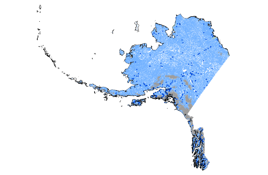
This geodatabase contains streams, waterbodies and wetlands, streamflow gaging stations, and coastlines for Alaska. The streams are incorporated into a geometric network. All feature classes are vertically integrated with each other and with 1:1,000,000-scale transportation and boundary data sets.
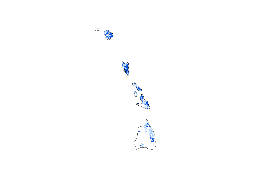
This geodatabase contains streams, waterbodies and wetlands, streamflow gaging stations, and coastlines for Hawaii. The streams are incorporated into a geometric network. All feature classes are vertically integrated with each other and with 1:1,000,000-scale transportation and boundary data sets.
This represents the flowline network in Connecting River Systems Restoration Assessment (CRSRA). It is attributed with the number of disconnections between the reach and the connecting river system. These data will help identify the condition of hydrologic separation between potential restoration areas and the connecting river system. Low numbers represent fewer disconnections such as culverts between the reach and the rivers requiring no flow network modification to restore the area.
Categories: Data;
Types: Citation,
Downloadable,
Map Service,
OGC WFS Layer,
OGC WMS Layer,
Shapefile;
Tags: Artificial Path,
Canal / Ditch,
Detroit River,
FWHydrography,
Great Lakes,
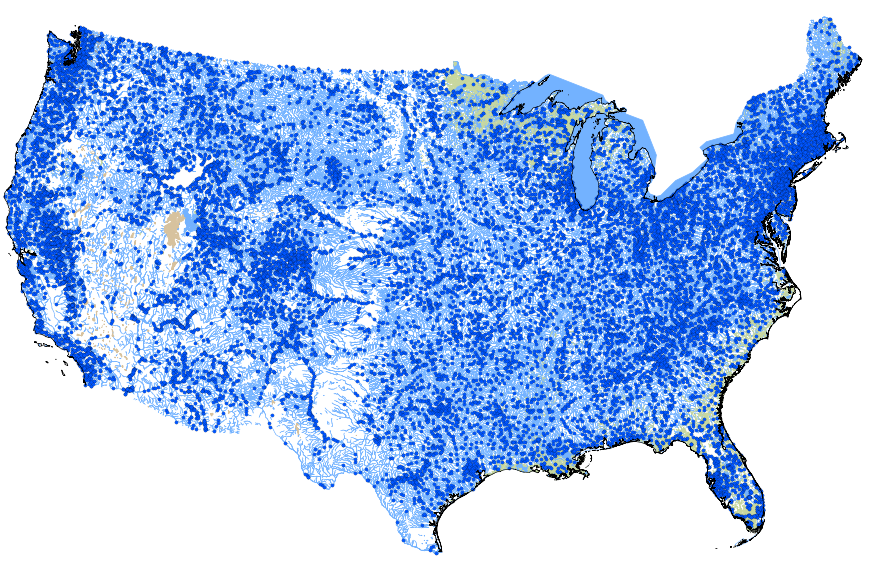
This geodatabase contains streams, waterbodies and wetlands, streamflow gaging stations, and coastlines for the conterminous United States. The streams are incorporated into a geometric network. All feature classes are vertically integrated with each other and with 1:1,000,000-scale transportation and boundary data sets.
This dataset is the output of a python script/ArcGIS model that identifes dikes as having a difference in elevation above a certain threshold. If the elevation difference was below a certain threshold the area was not considered a dike; however, if the difference in elevation between two points was significantly high then the area was marked as a dike. Areas continuous with eachother were considered part of the same dike. Post processing occured. Users examined the data output, comparing the proposed dike locations to aerial imagery, flowline data, and the DEM. Dikes that appeared to be false positives were deleted from the data set.
Categories: Data;
Types: Citation,
Downloadable,
Map Service,
OGC WFS Layer,
OGC WMS Layer,
Shapefile;
Tags: Great Lakes,
LIDAR,
Saginaw Bay,
biogeography,
coastal ecosystems,
This represents the flowline network in Sagina Bay Restoration Assessment (SBRA). It is attributed with the number of disconnections between the reach and the connecting river system. These data will help identify the condition of hydrologic separation between potential restoration areas and the connecting river system. Low numbers represent fewer disconnections such as culverts between the reach and the rivers requiring no flow network modification to restore the area.
Categories: Data;
Types: Citation,
Downloadable,
Map Service,
OGC WFS Layer,
OGC WMS Layer,
Shapefile;
Tags: Artificial Path,
Canal / Ditch,
FWHydrography,
Great Lakes,
Hydrography,
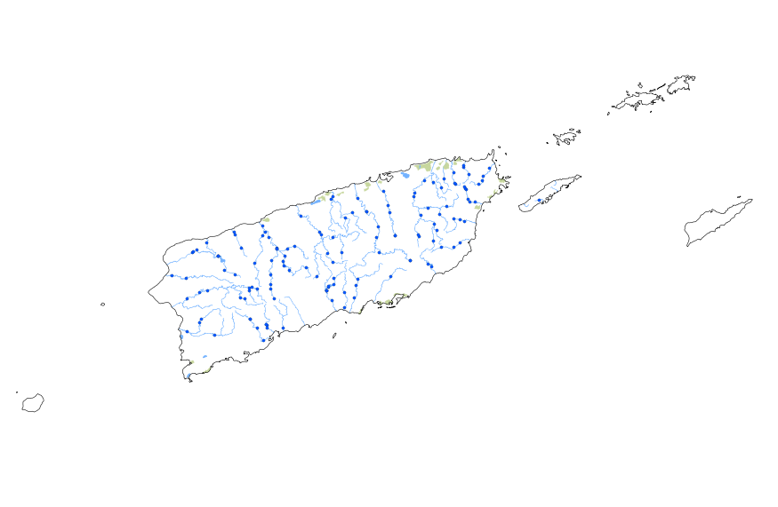
This geodatabase contains streams, waterbodies and wetlands, streamflow gaging stations, and coastlines for Puerto Rico and the U.S. Virgin Islands. The streams are incorporated into a geometric network. All feature classes are vertically integrated with each other and with 1:1,000,000-scale transportation and boundary data sets.
|

|
