Filters: Tags: drainage area (X)
38 results (28ms)|
Filters
Date Range
Extensions Types Contacts
Categories Tag Types
|
Variable Infiltration Capacity model results for several hydroclimatological variables for the Arkansas and Canadian River Basin of Oklahoma. Inputs to models were Daymet climate observations as well as the CCSM4, MIROC5, and MPI ESM LR Global Climate Models using Representative Concentration Pathways 2.6, 4.5 and 8.5.
This dataset consists of digitized 1:24,000-scale polylines and polygons representing hydrographic areas for the Walker River basin, California and Nevada.
Categories: Data;
Types: Downloadable,
Map Service,
OGC WFS Layer,
OGC WMS Layer,
Shapefile;
Tags: Antelope Valley,
Basin 106,
Basin 107,
Basin 108,
Basin 109,

These data were released prior to the October 1, 2016 effective date for the USGS’s policy dictating the review, approval, and release of scientific data as referenced in USGS Survey Manual Chapter 502.8 Fundamental Science Practices: Review and Approval of Scientific Data for Release. This dataset consists of drainage basin boundaries for 212 U.S. Geological Survey (USGS) stream sites sampled in the National Water-Quality Assessment (NAWQA) Program, the National Stream Quality Accounting Network (NASQAN), and the National Monitoring Network (NMN). Of the 212 sites, 206 have either a contributing or total drainage basin boundary, and the remaining 6 have both a total drainage basin boundary and a smaller contributing...
The National Elevation Dataset (NED) is the primary elevation data product produced and distributed by the USGS. The NED provides the best available public domain raster elevation data of the conterminous United States, Alaska, Hawaii, and territorial islands in a seamless format. The NED is derived from diverse source data, processed to a common coordinate system and unit of vertical measure. All NED data are distributed in geographic coordinates in units of decimal degrees, and in conformance with the North American Datum of 1983 (NAD 83). All elevation values are provided in units of meters, and are referenced to the North American Vertical Datum of 1988 (NAVD 88) over the conterminous United States. The vertical...
Types: Downloadable;
Tags: 1-DEGREE DEM,
2-ARC-SECOND DEM,
7.5-MINUTE DEM,
BLM,
Bureau of Land Management,
The National Elevation Dataset (NED) is the primary elevation data product produced and distributed by the USGS. The NED provides the best available public domain raster elevation data of the conterminous United States, Alaska, Hawaii, and territorial islands in a seamless format. The NED is derived from diverse source data, processed to a common coordinate system and unit of vertical measure. All NED data are distributed in geographic coordinates in units of decimal degrees, and in conformance with the North American Datum of 1983 (NAD 83). All elevation values are provided in units of meters, and are referenced to the North American Vertical Datum of 1988 (NAVD 88) over the conterminous United States. The vertical...
These data were released prior to the October 1, 2016 effective date for the USGS’s policy dictating the review, approval, and release of scientific data as referenced in USGS Survey Manual Chapter 502.8 Fundamental Science Practices: Review and Approval of Scientific Data for Release. As part of the U.S. Geological Survey's National Water-Quality Assessment Program, an investigation of the Yellowstone River Basin study unit is being conducted to document status and trends in surface- and ground-water quality. Surface-water samples are collected from streams (or lakes) at specific sampling stations. Water-quality characteristics at each station are influenced by the natural and cultural characteristics of the drainage...

These data were released prior to the October 1, 2016 effective date for the USGS’s policy dictating the review, approval, and release of scientific data as referenced in USGS Survey Manual Chapter 502.8 Fundamental Science Practices: Review and Approval of Scientific Data for Release. This dataset and the accompanying Data Series report was created to assist in analysis and interpretation of water-quality data provided by the U.S. Geological Survey, National Stream Quality Accounting Network (NASQAN) and the National Monitoring Network (NMN). The report describes the methods used to develop the geospatial data which was primarily derived from the National Watershed Boundary Dataset (WBD12). The geospatial data...
Groundwater Rechange Zones (>2000 m) created fron USGS NED. The National Elevation Dataset (NED) is the primary elevation data product produced and distributed by the USGS. The NED provides the best available public domain raster elevation data of the conterminous United States, Alaska, Hawaii, and territorial islands in a seamless format. The NED is derived from diverse source data, processed to a common coordinate system and unit of vertical measure. All NED data are distributed in geographic coordinates in units of decimal degrees, and in conformance with the North American Datum of 1983 (NAD 83). All elevation values are provided in units of meters, and are referenced to the North American Vertical Datum of...
The National Elevation Dataset (NED) is the primary elevation data product produced and distributed by the USGS. The NED provides the best available public domain raster elevation data of the conterminous United States, Alaska, Hawaii, and territorial islands in a seamless format. The NED is derived from diverse source data, processed to a common coordinate system and unit of vertical measure. All NED data are distributed in geographic coordinates in units of decimal degrees, and in conformance with the North American Datum of 1983 (NAD 83). All elevation values are provided in units of meters, and are referenced to the North American Vertical Datum of 1988 (NAVD 88) over the conterminous United States. The vertical...
Types: Downloadable;
Tags: 1-DEGREE DEM,
2-ARC-SECOND DEM,
7.5-MINUTE DEM,
BLM,
Bureau of Land Management,
Derived data layer based upon the NED. The National Elevation Dataset (NED) is the primary elevation data product produced and distributed by the USGS. The NED provides the best available public domain raster elevation data of the conterminous United States, Alaska, Hawaii, and territorial islands in a seamless format. The NED is derived from diverse source data, processed to a common coordinate system and unit of vertical measure. All NED data are distributed in geographic coordinates in units of decimal degrees, and in conformance with the North American Datum of 1983 (NAD 83). All elevation values are provided in units of meters, and are referenced to the North American Vertical Datum of 1988 (NAVD 88) over the...

These data were released prior to the October 1, 2016 effective date for the USGS’s policy dictating the review, approval, and release of scientific data as referenced in USGS Survey Manual Chapter 502.8 Fundamental Science Practices: Review and Approval of Scientific Data for Release. A digital representation of the watersheds of 43 sites on large river systems sampled by the National Stream Quality Accounting Network (NASQAN) of the U. S. Geological Survey (USGS) in 2000 was created primarily from 1:250,000 hydrologic units(HUCs) in the United States. Watershed information from Canada and Mexico was incorporated to complete the areas draining to the sampling sites from outside the United States. The sampled rivers...
Note: NED data can be accessed through The National Map (USGS). Instructions are available on The National Map Viewer homepage. The National Elevation Dataset (NED) is the primary elevation data product produced and distributed by the USGS. The NED provides the best available public domain raster elevation data of the conterminous United States, Alaska, Hawaii, and territorial islands in a seamless format. The NED is derived from diverse source data, processed to a common coordinate system and unit of vertical measure. All NED data are distributed in geographic coordinates in units of decimal degrees, and in conformance with the North American Datum of 1983 (NAD 83). All elevation values are provided in units of...
Categories: Data;
Types: Downloadable;
Tags: DEM,
Digital elevation model,
Digital terrain model,
Drainage Area,
Elevation,
This shapefile represents the watersheds present within the Crown of the Continent Ecosystem (CCE) boundary.(Note: a different CCE boundary layer was used at the time of creation, so the area amounts within the CCE may not be accurate)This dataset was developed by the Crown Managers Partnership, as part of a transboundary collaborative management initiative for the Crown of the Continent Ecosystem, based on commonly identified management priorities that are relevant at the landscape scale. The CMP is collaborative group of land managers, scientists, and stakeholder in the CCE. For more information on the CMP and its collaborators, programs, and projects please visit: http://crownmanagers.org/
Categories: Data;
Types: Downloadable,
Map Service,
OGC WFS Layer,
OGC WMS Layer,
Shapefile;
Tags: Alberta,
Alberta,
Alberta,
Alberta,
Canada,
These data were released prior to the October 1, 2016 effective date for the USGS’s policy dictating the review, approval, and release of scientific data as referenced in USGS Survey Manual Chapter 502.8 Fundamental Science Practices: Review and Approval of Scientific Data for Release. As part of the U.S. Geological Survey's National Water-Quality Assessment Program, an investigation of the Yellowstone River Basin study unit is being conducted to document status and trends in surface- and ground-water quality. Surface-water samples are collected from streams or lakes at specific sampling stations. Water-quality characteristics at each station are influenced by the natural and cultural characteristics of the drainage...
Categories: pre-SM502.8;
Tags: Montana,
NSDI,
North Dakota,
USGS Science Data Catalog (SDC),
Wyoming,

These data were released prior to the October 1, 2016 effective date for the USGS’s policy dictating the review, approval, and release of scientific data as referenced in USGS Survey Manual Chapter 502.8 Fundamental Science Practices: Review and Approval of Scientific Data for Release. The Drainage_Basin polygon feature class was created as a digital representation of drainage basins for more than 1,650 continuous-record streamflow-gaging stations, partial record streamflow-gaging stations of the U.S. Geological Survey (USGS), and other watercourse locations of interest. The Drainage_Basin polygon feature class replaces the drainage basins previously derived through planimetric methods on paper maps, and provides...
Categories: pre-SM502.8;
Tags: Maryland,
NSDI,
North Carolina,
Tennessee,
USGS Science Data Catalog (SDC),

These data were released prior to the October 1, 2016 effective date for the USGS’s policy dictating the review, approval, and release of scientific data as referenced in USGS Survey Manual Chapter 502.8 Fundamental Science Practices: Review and Approval of Scientific Data for Release. This data set consists of 204 drainage basin boundaries for U.S. Geological Survey's (USGS) stream sites sampled in the National Water Quality Assessment (NAWQA) Program and the National Stream Quality Accounting Network (NASQAN). These drainage basin boundaries are used to generate watershed characteristics for the development of water-quality models. The basin boundaries were collected from USGS hydrologists and geographers from...
Categories: pre-SM502.8;
Tags: Conterminous United States,
NASQAN,
NAWQA,
NSDI,
National Stream Quality Accounting Network,
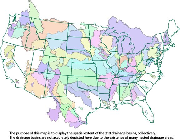
This dataset consists of drainage basin boundaries for 212 U.S. Geological Survey (USGS) stream sites sampled in the National Water-Quality Assessment (NAWQA) Program, the National Stream Quality Accounting Network (NASQAN), and the National Monitoring Network (NMN). Of the 212 sites, 206 have either a contributing or total drainage basin boundary, and the remaining 6 have both a total drainage basin boundary and a smaller contributing basin boundary. Collectively, these 218 basin boundaries have been used in a geographic information system (GIS) to generate basin characteristics for the assessment of trends in concentrations of pesticides streams of the United States.
Note: NED data can be accessed through The National Map (USGS). Instructions are available on The National Map Viewer homepage. The National Elevation Dataset (NED) is the primary elevation data product produced and distributed by the USGS. The NED provides the best available public domain raster elevation data of the conterminous United States, Alaska, Hawaii, and territorial islands in a seamless format. The NED is derived from diverse source data, processed to a common coordinate system and unit of vertical measure. All NED data are distributed in geographic coordinates in units of decimal degrees, and in conformance with the North American Datum of 1983 (NAD 83). All elevation values are provided in units of...
Categories: Data;
Types: Downloadable;
Tags: DEM,
Digital elevation model,
Digital terrain model,
Drainage Area,
Elevation,
Drainage basin areas for 376 USGS streamgages in West Virginia and adjacent states were delineated digitally. The USGS Watershed Boundary Dataset HUC12 sub-watershed lines were used as outer limits of basins, and heads-up digitizing was used to delineate boundaries from the stream gage to the HUC12 boundary. The USGS National Map was used, as background, to show both contour lines and digital elevation to highlight drainage basin divides, ridges, and valleys. Basins were delineated for (1) all active continuous-flow and crest-stage streamgages, in West Virginia, through water year 2020, (2) selected inactive streamgages, in West Virginia and adjacent states, that were used in the flood-frequency report prepared...
Categories: Data;
Types: ArcGIS REST Map Service,
ArcGIS Service Definition,
Downloadable,
Map Service,
OGC WFS Layer,
OGC WMS Layer,
OGC WMS Service;
Tags: Basin boundary,
Drainage area,
Drainage divide,
Hydrologic Unit,
Kentucky,
The National Elevation Dataset (NED) is the primary elevation data product produced and distributed by the USGS. The NED provides the best available public domain raster elevation data of the conterminous United States, Alaska, Hawaii, and territorial islands in a seamless format. The NED is derived from diverse source data, processed to a common coordinate system and unit of vertical measure. All NED data are distributed in geographic coordinates in units of decimal degrees, and in conformance with the North American Datum of 1983 (NAD 83). All elevation values are provided in units of meters, and are referenced to the North American Vertical Datum of 1988 (NAVD 88) over the conterminous United States. The vertical...
|

|
