Filters: Tags: drainage basin (X)
36 results (100ms)|
Filters
Date Range
Extensions Types Contacts
Categories Tag Types Tag Schemes |
A generalized least squares (GLS) technique was used with at-site n-day low-flow time series and frequencies, from SWToolbox (Kiang and others, 2018), and 14 basin characteristics (basin perimeter, drainage area, maximum basin elevation, mean total annual reference evapotranspiration, groundwater head, length of longest flow path, minimum basin elevation, runoff-curve number, relief, ruggedness, slope ratio, percentage of hydrologic soil type B, available water capacity, and total length of streams in a basin) for 28 selected streamflow gaging stations in Puerto Rico to calculate regional n-day low-flow frequency regression equations for ungaged stream locations. The GLS approach assigns weights based on uncertainty...
This raster dataset represents the boundaries of the hydrogeologic areas of the Southwest Principal Aquifer (SWPA) study of the National Water Quality Assessment (NAWQA) program. It is a compilation of the pre-existing Hydrogeologic Areas of the Southwest Ground-Water Resources Project, with additional data from the Central and Coastal basins of California, Northern New Mexico Rio Grande Valley, and South Central Colorado San Luis Valley.
This data release includes time-series data from a monitoring site located in a small drainage basin in the Arroyo Seco watershed in Los Angeles County, CA, USA (N3788964 E389956, UTM Zone 11, NAD83). The site was established after the 2009 Station Fire and recorded a series debris flows in the first winter after the fire. The data include three types of time-series: (1) 1-minute time series of rainfall, soil water content, channel bed pore pressure and temperature, and flow stage recorded by radar and laser distance meters (ArroyoSecoContinuous.csv); (2) 10-Hz time series of flow stage recorded by the laser distance meter during rain storms (ArroyoSecoStormLaser.csv), and (3) 2-second time series of rainfall and...
Categories: Data;
Types: Citation,
Map Service,
OGC WFS Layer,
OGC WMS Layer,
OGC WMS Service;
Tags: Arroyo Seco, California,
GHSC,
Geologic Hazards Science Center,
Landslides Hazards Program,
Los Angeles County, California,
One- and two-dimensional modelling of overland flow in semiarid shrubland, Jornada basin, New Mexico
Two distributed parameter models, a one-dimensional (1D) model and a two-dimensional (2D) model, are developed to simulate overland flow in two small semiarid shrubland watersheds in the Jornada basin, southern New Mexico. The models are event-based and represent each watershed by an array of 1-m2 cells, in which the cell size is approximately equal to the average area of the shrubs. Each model uses only six parameters, for which values are obtained from field surveys and rainfall simulation experiments. In the 1D model, flow volumes through a fixed network are computed by a simple finite-difference solution to the 1D kinematic wave equation. In the 2D model, flow directions and volumes are computed by a second-order...
Categories: Publication;
Types: Citation,
Journal Citation;
Tags: Hydrological Processes,
drainage basin,
hydrology,
infiltration,
overland flow,
Stormwater Action Monitoring (SAM) is a collaborative monitoring program between western Washington municipal stormwater permittees, state and federal agencies. SAM’s role is to use the results of regional monitoring and focused studies to inform policy decisions and identify effective strategies to improve stormwater management in the Puget Sound region. The SAM program includes status and trends monitoring of water quality, stream biota (macroinvertebrates, algae), and stream habitat to measure whether conditions are getting better or worse and identify patterns in healthy and impaired Puget Lowland streams. To meet this objective, a framework of fundamental geospatial data was required to develop physical and...
This raster dataset represents the boundaries of the hydrogeologic areas of the Southwest Principal Aquifer (SWPA) study of the National Water Quality Assessment (NAWQA) program. It is a compilation of the pre-existing Hydrogeologic Areas of the Southwest Ground-Water Resources Project, with additional data from the Central and Coastal basins of California, Northern New Mexico Rio Grande Valley, and South Central Colorado San Luis Valley.
This data release includes time-series data from a monitoring site located in a small (0.12 km2) drainage basin in the Las Lomas watershed in Los Angeles County, CA, USA. The site was established after the 2016 Fish Fire and recorded a series debris flows in the first winter after the fire. The station is located along the channel at the outlet of the study area (34 9’18.50”N, 117 56’41.33”W, WGS84). The data were collected between November 15, 2016 and February 23, 2017. The data include two types of time series: (1) continuous 1-minute time series of rainfall and flow stage recorded by a laser distance meter suspended over the channel (LasLomasContinuous.csv), and (2) 50-Hz time series of flow stage and flow-induced...
Categories: Data;
Tags: Ecology,
GHSC,
Geologic Hazards Science Center,
Landslides Hazards Program,
Las Lomas watershed,

These data were released prior to the October 1, 2016 effective date for the USGS’s policy dictating the review, approval, and release of scientific data as referenced in USGS Survey Manual Chapter 502.8 Fundamental Science Practices: Review and Approval of Scientific Data for Release. This dataset consists of drainage basin boundaries for 212 U.S. Geological Survey (USGS) stream sites sampled in the National Water-Quality Assessment (NAWQA) Program, the National Stream Quality Accounting Network (NASQAN), and the National Monitoring Network (NMN). Of the 212 sites, 206 have either a contributing or total drainage basin boundary, and the remaining 6 have both a total drainage basin boundary and a smaller contributing...

These data were released prior to the October 1, 2016 effective date for the USGS’s policy dictating the review, approval, and release of scientific data as referenced in USGS Survey Manual Chapter 502.8 Fundamental Science Practices: Review and Approval of Scientific Data for Release. The Mojave River and Morongo ground-water basins are in the southwestern part of the Mojave Desert in southern California. Ground-water from these basins supplies a major part of the water requirements for the region. The continuous population growth in this area has resulted in ever-increasing demands on local ground-water resources. The collection and interpretation of ground-water data helps local water districts, military bases,...
These data were released prior to the October 1, 2016 effective date for the USGS’s policy dictating the review, approval, and release of scientific data as referenced in USGS Survey Manual Chapter 502.8 Fundamental Science Practices: Review and Approval of Scientific Data for Release. As part of the U.S. Geological Survey's National Water-Quality Assessment Program, an investigation of the Yellowstone River Basin study unit is being conducted to document status and trends in surface- and ground-water quality. Surface-water samples are collected from streams (or lakes) at specific sampling stations. Water-quality characteristics at each station are influenced by the natural and cultural characteristics of the drainage...
An ordinary least squares (OLS) technique was used with at-site flow-duration exceedance probabilities, from SWToolbox (Kiang and others, 2018), and 14 basin characteristics (basin perimeter, drainage area, maximum basin elevation, mean total annual reference evapotranspiration, groundwater head, length of longest flow path, minimum basin elevation, runoff-curve number, relief, ruggedness, slope ratio, percentage of hydrologic soil type B, available water capacity, and total length of streams in a basin) for 28 selected streamflow gaging stations in Puerto Rico to calculate regional flow-duration regression equations for ungaged stream locations. The final flow-duration regression equations were developed in R (R...

These data were released prior to the October 1, 2016 effective date for the USGS’s policy dictating the review, approval, and release of scientific data as referenced in USGS Survey Manual Chapter 502.8 Fundamental Science Practices: Review and Approval of Scientific Data for Release. During 2010, the U.S. Geological Survey and other agencies made approximately 2,500 water-level measurements in the Mojave River and Morongo groundwater basins. These data document recent conditions and, when compared with previous data, changes in groundwater levels. A water-level contour map was drawn using data from about 610 wells, providing coverage for most of the basins. Twenty-eight hydrographs show long-term (up to 70 years)...

Drainage network of Papagni river basin, the project area of Foundation for Ecological Security. http://www.fes.org.in Downloaded from India Biodiversity Portal on January 17th, 2013

These data were released prior to the October 1, 2016 effective date for the USGS’s policy dictating the review, approval, and release of scientific data as referenced in USGS Survey Manual Chapter 502.8 Fundamental Science Practices: Review and Approval of Scientific Data for Release. This raster dataset represents the boundaries of the hydrogeologic areas of the Southwest Principal Aquifer (SWPA) study of the National Water Quality Assessment (NAWQA) program. It is a compilation of the pre-existing Hydrogeologic Areas of the Southwest Ground-Water Resources Project, with additional data from the Central and Coastal basins of California, Northern New Mexico Rio Grande Valley, and South Central Colorado San Luis...
These data were released prior to the October 1, 2016 effective date for the USGS’s policy dictating the review, approval, and release of scientific data as referenced in USGS Survey Manual Chapter 502.8 Fundamental Science Practices: Review and Approval of Scientific Data for Release. As part of the U.S. Geological Survey's National Water-Quality Assessment Program, an investigation of the Yellowstone River Basin study unit is being conducted to document status and trends in surface- and ground-water quality. Surface-water samples are collected from streams or lakes at specific sampling stations. Water-quality characteristics at each station are influenced by the natural and cultural characteristics of the drainage...
Categories: pre-SM502.8;
Tags: Montana,
NSDI,
North Dakota,
USGS Science Data Catalog (SDC),
Wyoming,

These data were released prior to the October 1, 2016 effective date for the USGS’s policy dictating the review, approval, and release of scientific data as referenced in USGS Survey Manual Chapter 502.8 Fundamental Science Practices: Review and Approval of Scientific Data for Release. During 2008, the U.S. Geological Survey and other agencies made approximately 2,500 water-level measurements in the Mojave River and Morongo groundwater basins. These data document recent conditions and, when compared with previous data, changes in groundwater levels. A water-level contour map was drawn using data from about 700 wells, providing coverage for most of the basins. Twenty-four hydrographs show long-term (up to 70 years)...

These data were released prior to the October 1, 2016 effective date for the USGS’s policy dictating the review, approval, and release of scientific data as referenced in USGS Survey Manual Chapter 502.8 Fundamental Science Practices: Review and Approval of Scientific Data for Release. The USGS compiles online access to water-resources data collected at approximately 1.5 million sites in all 50 States, the District of Columbia, Puerto Rico, the Virgin Islands, Guam, American Samoa and the Commonwealth of the Northern Mariana Islands.
Dams create barriers to fish migration and dispersal in drainage basins, and the removal of dams is often viewed as a means of increasing habitat availability and restoring migratory routes of several fish species. However, these barriers can also isolate and protect native taxa from aggressive downstream invaders.We examined fish community composition two years prior to and two years after the removal of a pair of low-head dams from Boulder Creek,Wisconsin, U.S.A. in 2003 to determine if removal of these potential barriers affected the resident population of native brook trout (Salvelinus fontinalis). Despite the presence of other taxa in the downstream reaches, and in other similar streams adjacent to the Boulder...
Categories: Publication;
Types: Citation;
Tags: Barrier,
Brook trout,
Brown trout fish,
Coldwater,
Colonization,
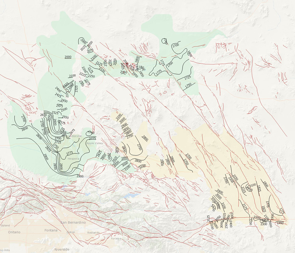
During 2014, the U.S. Geological Survey and other agencies made approximately 1,026 water-level measurements in the Mojave River and Morongo groundwater basins. These data document recent conditions and, when compared with previous data, changes in groundwater levels. A water-level contour map was drawn using data from about 610 wells, providing coverage for most of the basins. Twenty-four hydrographs show long-term (1930-2014) water-level conditions throughout the basins, and 9 short-term (1992 to 2014) hydrographs show the effects of recharge and discharge along the Mojave River. In addition, a water-level-change map was compiled to compare was compiled to compare the 2014 water levels to the 2012 water levels...
Categories: Data Release - Revised;
Tags: USGS,
USGS Science Data Catalog (SDC),
contours,
drainage basin,
ground water,

These data were released prior to the October 1, 2016 effective date for the USGS’s policy dictating the review, approval, and release of scientific data as referenced in USGS Survey Manual Chapter 502.8 Fundamental Science Practices: Review and Approval of Scientific Data for Release. The U.S. Geological Survey's National Water-Use Information Program is responsible for compiling and disseminating the nation's water-use data. The USGS works in cooperation with local, State, and Federal environmental agencies to collect water-use information. USGS compiles these data to produce water-use information aggregated at the county, state, and national levels. Every five years, data at the county level are compiled into...
|

|
