Filters: Tags: ecosystem (X)
325 results (16ms)|
Filters
Date Range
Extensions Types Contacts
Categories Tag Types Tag Schemes |

These data were released prior to the October 1, 2016 effective date for the USGS’s policy dictating the review, approval, and release of scientific data as referenced in USGS Survey Manual Chapter 502.8 Fundamental Science Practices: Review and Approval of Scientific Data for Release. Estuarine ecosystems are controlled by a variety of processes that operate at multiple spatial and temporal scales. Understanding the hierarchical nature of these processes will aid in prioritization of restoration efforts. This hierarchical Columbia River Estuary Ecosystem Classification (henceforth "Classification") of the Columbia River estuary is a spatial database of the tidally-influenced reaches of the lower Columbia River,...
The UWRM proposal represents the uplands wildlands network in the Heart of the West Proposal. Utah-Wyoming Rocky Mountains Ecoregion (UWRM) core areas and linkages shapefile. This GIS dataset provides core areas and linkages that includes all the components of a three track approach (special elements, representation, and focal species) used during the planning process. This is the result of a study contract by The Nature Conservancy to design an ecoregional plan for Northern Utah, Western Wyoming, Southeastern Idaho, Northwest Colorado and South-central Montana. The study was developed in 2001 by Reed Noss, George Wuerthner, Ken Vance-Borland, and Carlos Carroll from Conservation Science, Inc.
Categories: Data;
Types: ArcGIS REST Map Service,
ArcGIS Service Definition,
Downloadable,
Map Service,
OGC WFS Layer,
OGC WMS Layer,
Shapefile;
Tags: biota,
boundaries,
conservation assessment,
conservation plan,
conservation planning,
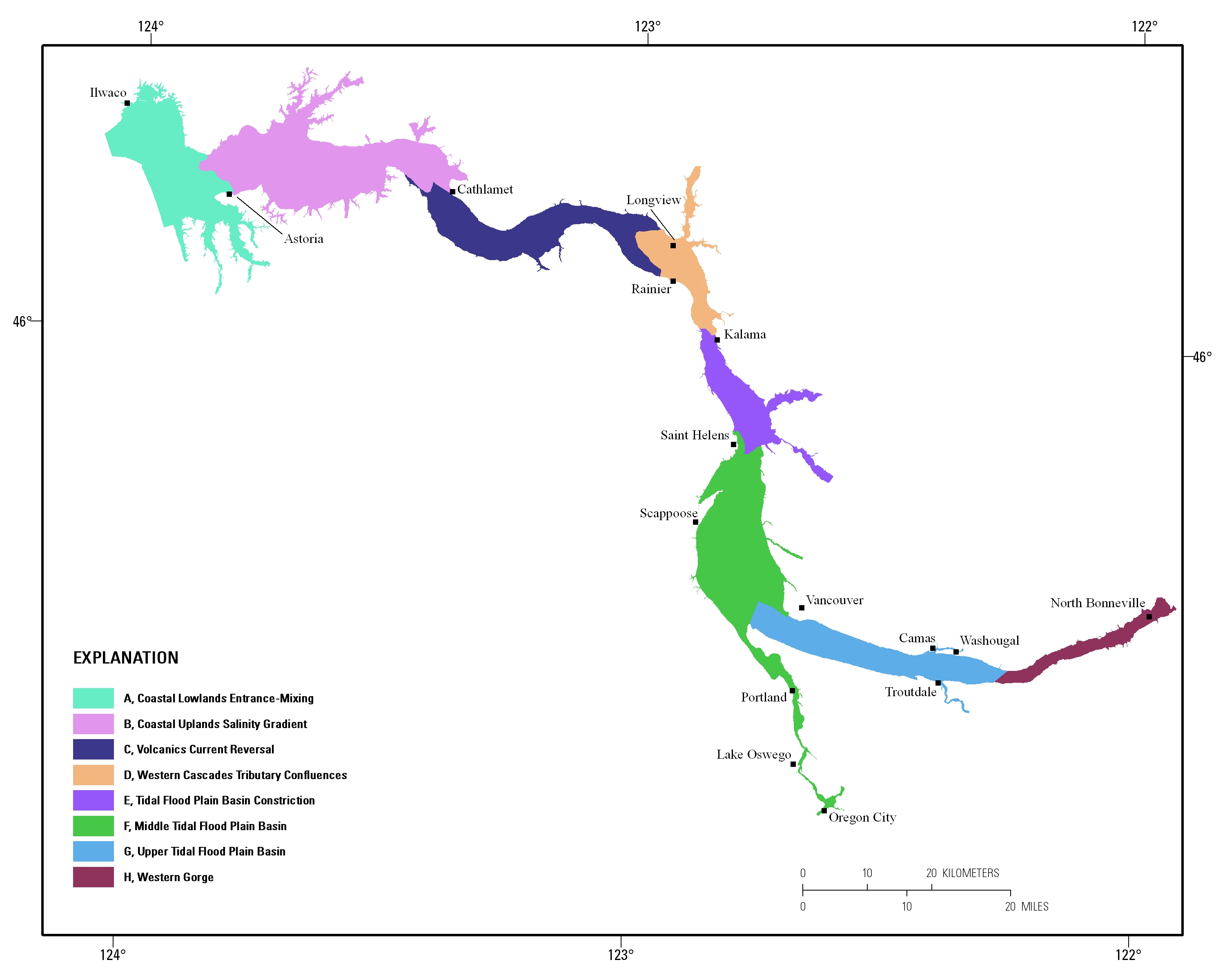
Estuarine ecosystems are controlled by a variety of processes that operate at multiple spatial and temporal scales. Understanding the hierarchical nature of these processes will aid in prioritization of restoration efforts. This hierarchical Columbia River Estuary Ecosystem Classification (henceforth "Classification") of the Columbia River estuary is a spatial database of the tidally-influenced reaches of the lower Columbia River, the tidally affected parts of its tributaries, and the landforms that make up their floodplains for the 230 kilometers between the Pacific Ocean and Bonneville Dam. This work is a collaborative effort between University of Washington School of Aquatic and Fishery Sciences (henceforth "UW"),...
Ecoregions denote areas of general similarity in ecosystems and in the type, quality, and quantity of environmental resources. They are designed to serve as a spatial framework for the research, assessment, management, and monitoring of ecosystems and ecosystem components. These general purpose regions are critical for structuring and implementing ecosystem management strategies across federal agencies, state agencies, and nongovernment organizations that are responsible for different types of resources within the same geographical areas. The approach used to compile this map is based on the premise that ecological regions can be identified through the analysis of patterns of biotic and abiotic phenomena, including...
Categories: Data;
Types: Downloadable,
Map Service,
Shapefile;
Tags: Biology,
Conservation,
Ecology,
Ecosystem,
Land,
This dataset summarizes impairment status for HUC12 watersheds at the CONUS scale using the EPA publicly available Assessment, Total Maximum Daily Load (TMDL) Tracking and Implementation System (ATTAINS) geospatial package and the USGS Watershed Boundary Dataset (WBD). ATTAINS is an online system maintained by the EPA containing information about the condition of the Nation’s surface waters, as reported by individual states. These data were downloaded in October 2023 and primarily reflect 2022 stream conditions. Because of the varying data types that exist in the database, an independent methodology was developed for summarizing impairment status for HUC12 watersheds using the USGS WBD as detailed in this metadata...
For comparing impacts of bird and bat collisions with wind turbines, investigators estimate fatalities/megawatt (MW) of rated capacity/year, based on periodic carcass searches and trials used to estimate carcasses not found due to scavenger removal and searcher error. However, scavenger trials typically place >=10 carcasses at once within small areas already supplying scavengers with carcasses deposited by wind turbines, so scavengers may be unable to process and remove all placed carcasses. To avoid scavenger swamping, which might bias fatality estimates low, we placed only 1-5 bird carcasses at a time amongst 52 wind turbines in our 249.7-ha study area, each carcass monitored by a motion-activated camera. Scavengers...
To inform the design and implementation of land-use policies that consider the variety of goods and services people derive from ecosystems, it is essential to understand spatial patterns of individual services, how multiple services relate to each other, and how these relationships vary across spatial scales and localities. Despite the importance of freshwater as a determinant of regional economic and human demographic patterns, there are surprisingly few studies that map the provision of a range of services associated with the quality of the aquatic environment. Here we examine relationships between indicators of riverine water and associated habitat quality, freshwater biodiversity, three terrestrial ecosystem...
Categories: Publication;
Types: Citation;
Tags: Biology,
Biology: methods,
Classification,
Classification: methods,
Computational Biology,
BLM REA CBR 2010 Greater Sage Grouse - Maximum connectivity value of sage grouse leks (reclassified)
Scorecard analysis for the terrestrial conservation element Greater Sage Grouse and current landscape permiability using circuitscape. The analysis is based upon location data using the lek locations (CBR_TS_C_175855_GSG_BreedingDensity100_poly). The cost surface is derived from the landscape condition score of current condition (CBR_DV_N_NATURESERVE_LANDSCAPECON_2010.img). This layer represents the maximum current value which has been reclassed all values that are > 1 = 1 and converted a 0-100 scale for analysis within a GIS. NatureServe’s ecological integrity framework provides a practical approach to organize criteria and indicators for this purpose (Faber-Langendoen et al. 2006, Unnasch et al. 2008). This framework...
Types: Downloadable;
Tags: BLM,
Biology,
Bureau of Land Management,
CBR 2010,
Central Basin and Range,
Both tabular and spatial models were used to predict fire regime departure at the sub-watershed scale (i.e., HUC 10 units). Integrating the fire regime models with predicted changes in climate envelopes provides a clearer understanding of how these ecological systems are likely to respond to multiple stresses. The natural range of variability for each CE was initially derived from LANDFIRE Vegetation Dynamics Development Tool (VDDT) models. The VDDT allows for the development of probabilistic quantitative model of CEs consisting of multiple ecological states with both deterministic and probabilistic drivers. For any defined suite of drivers, the models predict the relative abundance of each state within a defined...
Types: Downloadable;
Tags: BLM,
Bureau of Land Management,
CBR 2010,
Central Basin and Range,
Climate,
This dataset was derived from 'NatureServe L48 ESLF V2.7'. See process steps for additional information. The dataset represents the work of multiple states and Federal agencies as part of the US Gap Analysis and LandFire programs. Multi-season satellite imagery (Landsat ETM+) from 1999-2001 were used in conjunction with digital elevation model (DEM) derived datasets (e.g. elevation, landform) to model natural and semi-natural vegetation. The minimum mapping unit for this dataset is approximately 1 acre. Landcover classes are drawn from NatureServe's Ecological System concept. Five-hundred and fourty-four land cover classes composed of 12 cultural and 532 Natural/Semi-natural types are described. Land cover classes...
Both tabular and spatial models were used to predict fire regime departure at the sub-watershed scale (i.e., HUC 10 units). Integrating the fire regime models with predicted changes in climate envelopes provides a clearer understanding of how these ecological systems are likely to respond to multiple stresses. The natural range of variability for each CE was initially derived from LANDFIRE Vegetation Dynamics Development Tool (VDDT) models. The VDDT allows for the development of probabilistic quantitative model of CEs consisting of multiple ecological states with both deterministic and probabilistic drivers. For any defined suite of drivers, the models predict the relative abundance of each state within a defined...
BLM REA MBR 2010 Ecological System Fire Regime Departure 2060 - SonoranMidElevationDesertScrub Mesic
Both tabular and spatial models were used to predict fire regime departure at the sub-watershed scale (i.e., HUC 10 units). Integrating the fire regime models with predicted changes in climate envelopes provides a clearer understanding of how these ecological systems are likely to respond to multiple stresses. The natural range of variability for each CE was initially derived from LANDFIRE Vegetation Dynamics Development Tool (VDDT) models. The VDDT allows for the development of probabilistic quantitative model of CEs consisting of multiple ecological states with both deterministic and probabilistic drivers. For any defined suite of drivers, the models predict the relative abundance of each state within a defined...
This map shows the degree of stress on hydrologic integrity, specifically the stress on water quality from mercury and nitrate deposition, and sediment loading. These data are provided by Bureau of Land Management (BLM) "as is" and may contain errors or omissions. The User assumes the entire risk associated with its use of these data and bears all responsibility in determining whether these data are fit for the User's intended use. These data may not have the accuracy, resolution, completeness, timeliness, or other characteristics appropriate for applications that potential users of the data may contemplate. The User is encouraged to carefully consider the content of the metadata file associated with these data....
This map shows the current and near-term status of terrestrial ecosystems, in addition to the input datasets used for the analysis and distribution modeling that were involved in producing these status datasets.These data are provided by Bureau of Land Management (BLM) "as is" and may contain errors or omissions. The User assumes the entire risk associated with its use of these data and bears all responsibility in determining whether these data are fit for the User's intended use. These data may not have the accuracy, resolution, completeness, timeliness, or other characteristics appropriate for applications that potential users of the data may contemplate. The User is encouraged to carefully consider the content...
This map shows the status of aquatic ecosystems, in addition to the input datasets used for the analysis and distribution modeling that were involved in producing these status datasets. These data are provided by Bureau of Land Management (BLM) "as is" and may contain errors or omissions. The User assumes the entire risk associated with its use of these data and bears all responsibility in determining whether these data are fit for the User's intended use. These data may not have the accuracy, resolution, completeness, timeliness, or other characteristics appropriate for applications that potential users of the data may contemplate. The User is encouraged to carefully consider the content of the metadata file associated...
This map shows the location of the Colorado Plateau Ecoregion. These data are provided by Bureau of Land Management (BLM) "as is" and may contain errors or omissions. The User assumes the entire risk associated with its use of these data and bears all responsibility in determining whether these data are fit for the User's intended use. These data may not have the accuracy, resolution, completeness, timeliness, or other characteristics appropriate for applications that potential users of the data may contemplate. The User is encouraged to carefully consider the content of the metadata file associated with these data. The BLM should be cited as the data source in any products derived from these data.
This map shows the current distribution of terrestrial ecosystems, in addition to the input datasets used when these distributions were modeled. These data are provided by Bureau of Land Management (BLM) "as is" and may contain errors or omissions. The User assumes the entire risk associated with its use of these data and bears all responsibility in determining whether these data are fit for the User's intended use. These data may not have the accuracy, resolution, completeness, timeliness, or other characteristics appropriate for applications that potential users of the data may contemplate. The User is encouraged to carefully consider the content of the metadata file associated with these data. The BLM should...
These data are provided by Bureau of Land Management (BLM) "as is" and may contain errors or omissions. The User assumes the entire risk associated with its use of these data and bears all responsibility in determining whether these data are fit for the User's intended use. These data may not have the accuracy, resolution, completeness, timeliness, or other characteristics appropriate for applications that potential users of the data may contemplate. The User is encouraged to carefully consider the content of the metadata file associated with these data. The BLM should be cited as the data source in any products derived from these data.
|

|
