Filters: Tags: eems (X)
6 results (76ms)|
Filters
Date Range
Types Contacts
Categories Tag Types
|
Prioritization for maintenance of intact habitat (i.e., habitat quality rating of Good or Very Good), based on local scale ecological integrity, degree of threats faced, potential conservation opportunities, and conservation value of surrounding landscape. In contrast to ecological integrity ratings; threat, opportunity and landscape rankings are largely based on the range of values of any given indicator across the geography, sorted by quantile. There are some exceptions, particularly for indicators used to develop threat rankings (e.g., urban development risk).Prioritization for restoration of degraded habitat (i.e., habitat quality rating of Fair or Poor), based on local scale ecological integrity, potential...
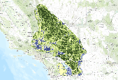
This dataset provides an estimate of current terrestrial intactness (i.e. condition) based on the extent to which human impacts such as agriculture, urban development, natural resource extraction, and invasive species have disrupted the landscape across the State of Utah. Terrestrial intactness values will be high in areas where these impacts are low.This 1 km2 resolution dataset (v13F) was created for the Colorado Plateau REA stepdown analysis using the open-source logic modeling framework Environmental Evaluation Modeling System (EEMS). Spatially-explicit logic modeling hierarchically integrates numerous and diverse datasets into composite layers, quantifying information in a continuous rather than binary fashion....
Ecological integrity of priority habitats was based on degree of local human development, amount and local connectivity of habitat, and quality of habit. Indicators were selected to reflect the needs of focal species, as well as other key ecological attributes of these habitats. Ecological integrity was estimated for floodplain forests, freshwater wetlands, human development, major rivers, rice agriculture, tallgrass prairie, and tidal wetlands.Ratings of each indicator are based on a viability assessment conducted following the Open Standards framework. Indicators with ratings of Good or Very Good are within the acceptable range of natural variation (with Good suggesting some management may be needed to get the...
This geodatabase contains inputs used in creating the Edwards to the Gulf Conservation Blueprint. These datasets include county boundaries, HUC12 watersheds, project boundary, open water extent, protected areas, and shallow water oyster reefs.
1KM Results: Current Terrestrial Landscape Intactness in the DRECP Study Area, 12km Buffer (Draft v15a) - This version is a draft intended for internal DRECP review only. See EEMS model diagram attached. Change log:1. Vegetation (Fire Regime) Departure was reclassified as follows: Agriculture, Urban, Departure Not Calculated -> NoDataSparse Vegetation, Barren, Snow/Ice, Water -> 0In previous versions, all of the aforementioned categories were calculated as NoData. 2. Change Vegetation Departure weight from 0.05 (v14a) to 0.23. Change Agricultural Development weight from 0.7 (v14a) to 0.5 This dataset provides an estimate of current terrestrial intactness, based on an EEMS fuzzy logic model that integrates multiple...
Prioritization for protection of habitat (via acquisition or easements), based on local scale ecological integrity, degree of threats faced, potential conservation opportunities, and conservation value of surrounding landscape. In contrast to ecological integrity ratings; threat, opportunity and landscape rankings are largely based on the range of values of any given indicator across the geography, sorted by quantile. There are some exceptions, particularly for indicators used to develop threat rankings (e.g., urban development risk). EEMS is a tree-based, fuzzy logic modeling system, where output values range from -1 to +1, indicating whether a given output is entirely FALSE or TRUE, respectively. Indicators with...
|

|
