Filters: Tags: et (X)
36 results (62ms)|
Filters
Date Range
Extensions Types Contacts
Categories Tag Types
|

This dataset represents "phreatophyte areas" mapped as part of a groundwater reconnaissance effort in four valleys in central Nevada and published in 1964. The data were digitized for comparison with mapping of groundwater discharge areas done in 2011 as part of a groundwater study in these valleys published in 2016.
These data were compiled for monitoring riparian zone trends and changes in the Lower Colorado Delta as part of the Minute 139 of the 1944 Water Treaty between the United States and Mexico. The quality and quantity of the Delta’s riparian and aquatic ecosystems have been dramatically reduced over the past century, due largely to significant alterations to natural hydrologic and sediment regimes. The Minute 319 Agreement states that 130 million cubic meters of water was to be released during the spring of 2014. Water was released from Morelos Dam at the Northern International Border (NIB) near Yuma, Arizona, to the river’s delta in Mexico, allowing water to reach the Gulf of California for the first time in 13 years...
The groundwater discharge area (GDA) in Tule and part of Sevier valley represents the area where discharge from evaporation by open water or bare soil and transpiration from phreatophytic plants exceeds the volume of water contributed by precipitation. The GDA was delineated during field reconnaissance of the study area using techniques similar to those used in previous studies throughout Nevada and eastern Utah.
Categories: Data;
Types: Downloadable,
Map Service,
OGC WFS Layer,
OGC WMS Layer,
Shapefile;
Tags: ET,
Great Basin,
Juab County,
Millard County,
Utah,
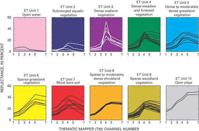
These data were released prior to the October 1, 2016 effective date for the USGS’s policy dictating the review, approval, and release of scientific data as referenced in USGS Survey Manual Chapter 502.8 Fundamental Science Practices: Review and Approval of Scientific Data for Release. The raster-based classification of evapotranspiration (ET) units is for nine major discharge areas in the Death Valley regional flow system. The ET units delineate general areas of similar vegetation and soil-moisture conditions. Classifications were derived from Landsat Thematic Mapper imagery data acquired June 13, 1992; Sept. 1, 1992; and June 21, 1989.
These data were released prior to the October 1, 2016 effective date for the USGS’s policy dictating the review, approval, and release of scientific data as referenced in USGS Survey Manual Chapter 502.8 Fundamental Science Practices: Review and Approval of Scientific Data for Release. The raster-based classification of evapotranspiration (ET) units is for nine major discharge areas in the Death Valley regional flow system. The ET units delineate general areas of similar vegetation and soil-moisture conditions. Classifications were derived from Landsat Thematic Mapper imagery data acquired June 13, 1992; Sept. 1, 1992; and June 21, 1989.
This project applies ET remote sensing at two scales, 1) across the full landscape at 1000 m MODIS resolution (as a component of the water budget to support water availability studies, and 2) on agricultural lands at 100 m Landsat resolution (for estimating crop water use).

These data were released prior to the October 1, 2016 effective date for the USGS’s policy dictating the review, approval, and release of scientific data as referenced in USGS Survey Manual Chapter 502.8 Fundamental Science Practices: Review and Approval of Scientific Data for Release. With increasing population growth and land-use change, urban communities in the desert southwest are progressively looking to remote basins to supplement existing water supplies. Recent applications for groundwater appropriations from Dixie Valley, Nevada, a primarily undeveloped basin neighboring the Carson Desert to the east, have prompted a reevaluation of the quantity of naturally discharging groundwater. The objective of this...
This USGS data release, supporting USGS Scientific Investigations Report 2020-5075, Estimates of Groundwater Discharge by Evapotranspiration, Stump Spring and Hiko Springs, Clark County, Southern Nevada, 2016–18, consists of five datasets - Normalized Difference Vegetation Indexes (NDVI) and a mapped groundwater discharge areas (GDA) for two spring areas, and a two-class land cover classification for Stump Springs and the Area of Critical Environmental Concern (ACEC) adjacent to Stump Springs. The mapped GDAs are the area within each spring’s riparian area where discharge from evaporation by open water or bare soil and transpiration from phreatophytic plants exceeds the volume of water contributed by precipitation....
This dataset, created in support of USGS Scientific Investigations Report 2020-5075, Estimates of Groundwater Discharge by Evapotranspiration, Stump Spring and Hiko Springs, Clark County, Nevada, 2016-18, represents a Normalized Difference Vegetation Index calculated for vegetated areas in the Hiko Springs groundwater discharge area. Vegetated areas within the GDA are composed of phreatophytic shrubs interspersed with xeric vegetation and bare soil. The GDA was delineated by visual interpretation of 1-meter National Agriculture Imagery Program (NAIP) aerial imagery acquired in May of 2015. Areas of channel scour within the GDA resulting from a flood event in September 2015 were delineated from a 2016 1.84-meter...
Categories: Data;
Types: Downloadable,
GeoTIFF,
Map Service,
Raster;
Tags: Clark County,
ET,
Hiko Springs,
Nevada,
evaporation,
The mean MSAVI image is based on two Landsat 5 Thematic Mapper (TM) scenes representing midsummer conditions in 2007 and 2008. MSAVI was calculated for each image which were then combined by calculating the mean for each pixel in the scenes. The resultant MSAVI image was used to estimate vegetation assemblages (ET units) within a mapped groundwater discharge area.
Categories: Data;
Types: Downloadable,
GeoTIFF,
Map Service,
Raster;
Tags: ET,
Great Basin,
Juab County,
Millard County,
Utah,
This data set contains polygons representing potential areas of groundwater discharge (PAGWD) for the upper Humboldt River Basin, northeastern Nevada.
Categories: Data;
Types: Downloadable,
Map Service,
OGC WFS Layer,
OGC WMS Layer,
Shapefile;
Tags: Discharge,
Dixie Creek-Tenmile Creek,
ET,
ET unit,
Elko Segment,
These data were compiled for monitoring riparian zone trends and changes in the Lower Colorado Delta as part of the Minute 139 of the 1944 Water Treaty between the United States and Mexico. The quality and quantity of the Delta’s riparian and aquatic ecosystems have been dramatically reduced over the past century, due largely to significant alterations to natural hydrologic and sediment regimes. The Minute 319 Agreement states that 130 million cubic meters of water was to be released during the spring of 2014. Water was released from Morelos Dam at the Northern International Border (NIB) near Yuma, Arizona, to the river’s delta in Mexico, allowing water to reach the Gulf of California for the first time in 13 years...
These data were compiled for evaluating plant water use, or river-reach level evapotranspiration (ET) data, in the riparian corridor of the Colorado River delta as specified under Minute 319 of the 1944 Water Treaty. The seven reach areas from the Northerly International Boundary (NIB) to the end of the delta at the Sea of Cortez were defined for research activities. Also, these seven reaches are being monitored under Minute 323 of the 1944 Water Treaty. Additionally, these data were compiled for evaluating restoration-level data in Reach 2 and Reach 4, as specified under Minute 323 of the 1944 Water Treaty. Objectives of our study were to measure the peak growing season evapotranspiration (ET) for the average of...
These raster and tabular data were compiled to develop time series data of the lower Colorado River (LCR) vegetation greenness, water use, and phenology since the year 2000. An objective of our study was to evaluate short and long-term effects of drought and biocontrol on LCR riparian and aquatic ecosystems south of Hoover Dam. These data represent spatially explicit average Enhanced Vegetation Index (EVI2) derived evapotranspiration (ET) difference, and scaled normalized difference vegetation index (NDVI*) difference maps between two decades (2000 to 2010 and 2011 to 2020) and two 5 year periods (2000 to 2005 and 2016 to 2020). The time-series period statistics data provide estimates of the riparian woodland area...
This dataset, created in support of USGS Scientific Investigations Report 2020-5075, Estimates of Groundwater Discharge by Evapotranspiration, Stump Spring and Hiko Springs, Clark County, Nevada, 2016-18, represents the groundwater discharge area (GDA) for the Stump Springs riparian area and Area of Critical Environmental Concern (ACEC). Vegetated areas within the GDA are composed of phreatophytic shrubs interspersed with xeric vegetation and bare soil. The GDA was delineated by visual interpretation of 1-meter National Agriculture Imagery Program (NAIP) aerial imagery acquired in May of 2015. The ACEC boundary was determined by the Bureau of Land Management.
Categories: Data;
Types: Downloadable,
Map Service,
OGC WFS Layer,
OGC WMS Layer,
Shapefile;
Tags: Clark County,
ET,
Nevada,
Stump Spring,
climatologyMeteorologyAtmosphere,
This dataset, created in support of USGS Scientific Investigations Report 2020-5075, Estimates of Groundwater Discharge by Evapotranspiration, Stump Spring and Hiko Springs, Clark County, Nevada, 2016-18, represents a Normalized Difference Vegetation Index calculated for vegetated areas in the Stump Spring groundwater discharge area (GDA) and Area of Critical Environmental Concern (ACEC). Vegetated areas within the GDA are composed of phreatophytic shrubs interspersed with xeric vegetation and bare soil. The GDA was delineated by visual interpretation of 1-meter National Agriculture Imagery Program (NAIP) aerial imagery acquired in May of 2015. The NDVI was calculated from a June 2017 WorldView 2 image resampled...
Categories: Data;
Types: Downloadable,
GeoTIFF,
Map Service,
Raster;
Tags: Clark County,
ET,
Nevada,
Stump Spring,
biota,

This dataset represents "phreatophyte areas" mapped as part of an analysis of irrigation pumping in Diamond Valley, Nevada published in 1968. The data were digitized for comparison with mapping of groundwater discharge areas done in 2011 as part of a groundwater study in these valleys published in 2016.
These data were created as part of a hydrologic study to characterize groundwater budgets and water quality in the Diamond Valley Flow System (DVFS), central Nevada. This dataset represents evapotranspiration (ET) units derived from the mean Enhanced Vegetation Index (EVI) calculated from two Landsat 5 Thematic Mapper scenes from the summer of 2010. ET units were defined within the DVFS groundwater discharge area (GDA) to group areas characterized by similar phreatophytic vegetation type and cover and to extrapolate site-scale groundwater ET estimates across the study area. This dataset represents three ET units: shrubland, grassland, and playa. The shrubland unit is composed of low to high density phreatophytic...

These data were created as part of a hydrologic study to characterize groundwater budgets and water quality in the Diamond Valley Flow System (DVFS), central Nevada. This dataset represents the groundwater discharge area (GDA) in the DVFS. Vegetated areas within the GDA are composed of phreatophytic shrubs with smaller areas of grassland, marshland, xeric vegetation, bare soil, and agricultural lands where phreatophytic shrubs historically were present. Vegetated areas outside the GDA are primarily composed of xeric vegetation and bare soil although very sparse phreatophytic shrubs may be present on the outer margins of the boundary. The GDA was mapped in the summer of 2011 using field reconnaissance and supporting...

These data were released prior to the October 1, 2016 effective date for the USGS’s policy dictating the review, approval, and release of scientific data as referenced in USGS Survey Manual Chapter 502.8 Fundamental Science Practices: Review and Approval of Scientific Data for Release. With increasing population growth and land-use change, urban communities in the desert southwest are progressively looking to remote basins to supplement existing water supplies. Recent applications for groundwater appropriations from Dixie Valley, Nevada, a primarily undeveloped basin neighboring the Carson Desert to the east, have prompted a reevaluation of the quantity of naturally discharging groundwater.The objective of this...
|

|
