Filters: Tags: impervious (X)
57 results (68ms)|
Filters
Date Range
Extensions Types
Contacts
Categories Tag Types Tag Schemes |

Zone 24 (covering small portions of Michigan and New York) of the contiguous U.S. percent developed imperviousness dataset from NLCD 2006, released 2/16/2011. The full dataset is divided into 25 zones, which can all be found in the NLCD 2006 gallery. The National Land Cover Database products are created through a cooperative project conducted by the Multi-Resolution Land Characteristics (MRLC) Consortium. The MRLC Consortium is a partnership of federal agencies (www.mrlc.gov), consisting of the U.S. Geological Survey (USGS), the National Oceanic and Atmospheric Administration (NOAA), the U.S. Environmental Protection Agency (EPA), the U.S. Department of Agriculture (USDA), the U.S. Forest Service (USFS), the...

Zone 23 (covering parts of Minnesota, Wisconsin, and Michigan) of the contiguous U.S. percent developed imperviousness dataset from NLCD 2006, released 2/16/2011. The full dataset is divided into 25 zones, which can all be found in the NLCD 2006 gallery. The National Land Cover Database products are created through a cooperative project conducted by the Multi-Resolution Land Characteristics (MRLC) Consortium. The MRLC Consortium is a partnership of federal agencies (www.mrlc.gov), consisting of the U.S. Geological Survey (USGS), the National Oceanic and Atmospheric Administration (NOAA), the U.S. Environmental Protection Agency (EPA), the U.S. Department of Agriculture (USDA), the U.S. Forest Service (USFS),...

Zone 21 (covering parts of Montana, North Dakota, and South Dakota) of the contiguous U.S. percent developed imperviousness dataset from NLCD 2006, released 2/16/2011. The full dataset is divided into 25 zones, which can all be found in the NLCD 2006 gallery. The National Land Cover Database products are created through a cooperative project conducted by the Multi-Resolution Land Characteristics (MRLC) Consortium. The MRLC Consortium is a partnership of federal agencies (www.mrlc.gov), consisting of the U.S. Geological Survey (USGS), the National Oceanic and Atmospheric Administration (NOAA), the U.S. Environmental Protection Agency (EPA), the U.S. Department of Agriculture (USDA), the U.S. Forest Service (USFS),...

Zone 15 (covering parts of South Dakota, Nebraska, Kansas, Missouri, Iowa, Minnesota, and Wisconsin) of the contiguous U.S. percent developed imperviousness dataset from NLCD 2006, released 2/16/2011. The full dataset is divided into 25 zones, which can all be found in the NLCD 2006 gallery. The National Land Cover Database products are created through a cooperative project conducted by the Multi-Resolution Land Characteristics (MRLC) Consortium. The MRLC Consortium is a partnership of federal agencies (www.mrlc.gov), consisting of the U.S. Geological Survey (USGS), the National Oceanic and Atmospheric Administration (NOAA), the U.S. Environmental Protection Agency (EPA), the U.S. Department of Agriculture (USDA),...

Zone 5 (covering parts of California and Nevada) of the contiguous U.S. percent developed imperviousness dataset from NLCD 2006, released 2/16/2011. The full dataset is divided into 25 zones, which can all be found in the NLCD 2006 gallery. The National Land Cover Database products are created through a cooperative project conducted by the Multi-Resolution Land Characteristics (MRLC) Consortium. The MRLC Consortium is a partnership of federal agencies (www.mrlc.gov), consisting of the U.S. Geological Survey (USGS), the National Oceanic and Atmospheric Administration (NOAA), the U.S. Environmental Protection Agency (EPA), the U.S. Department of Agriculture (USDA), the U.S. Forest Service (USFS), the National...

This dataset portrays percent imperviousness surface area for NLCD mapping superzone four, covering most of Utah and Colorado, and parts of Wyoming, Montana, Idaho, Nevada, Arizona, and New Mexico. Refer to http://www.mrlc.gov/nlcd_multizone_map.php for a map of the super-zones. From NLCD: The National Land Cover Database 2001 was produced through a cooperative project conducted by the Multi-Resolution Land Characteristics (MRLC) Consortium. The MRLC Consortium is a partnership of federal agencies (www.mrlc.gov), consisting of the U.S. Geological Survey (USGS), the National Oceanic and Atmospheric Administration (NOAA), the U.S. Environmental Protection Agency (EPA), the U.S. Department of Agriculture (USDA),...
Tags: impervious,
land cover
This geodatabse set contains the attributes and indicators associated with aquatic EI were categorized by size, landscape context, and conditionset in the Northwestern Plains Ecoregion. The data for the Aquatic EI used information from the Aquatic Threat analysis performed by the Missouri River Assesment Program (MoRAP). The MoRAP aquatic threat analysis contains information about each threat analysis attribute, indicator and metric arbitrarily quantified (1,2,3) for the 6th level Hydrological Unit (HUC12). These attributes were calculated for the entire HUC 12, the streams within the HUC 12, or the riparian corridor within the HUC 12. For this analysis MoRAP used arbitrary values were assigned good =3, fair =2...
Types: Live Data;
Tags: Aquatic Ecological Intactness,
BLM,
Bureau of Land Management,
DOI,
Geospatial,

Zone 22 (covering parts of North Dakota, South Dakota, Minnesota, and Wisconsin) of the contiguous U.S. percent developed imperviousness dataset from NLCD 2006, released 2/16/2011. The full dataset is divided into 25 zones, which can all be found in the NLCD 2006 gallery. The National Land Cover Database products are created through a cooperative project conducted by the Multi-Resolution Land Characteristics (MRLC) Consortium. The MRLC Consortium is a partnership of federal agencies (www.mrlc.gov), consisting of the U.S. Geological Survey (USGS), the National Oceanic and Atmospheric Administration (NOAA), the U.S. Environmental Protection Agency (EPA), the U.S. Department of Agriculture (USDA), the U.S. Forest...
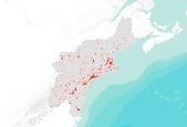
This dataset portrays percent imperviousness surface area for NLCD mapping superzone thirteen, which covers all of Maine, Vermont, New Hampshire, Massachusetts, Rhode Island, Connecticut, New York, New Jersey, Delaware, and Maryland, and parts of Pennsylvania, Virginia, West Virginia, and North Carolina. Refer to http://www.mrlc.gov/nlcd_multizone_map.php for a map of the super-zones. From NLCD: The National Land Cover Database 2001 was produced through a cooperative project conducted by the Multi-Resolution Land Characteristics (MRLC) Consortium. The MRLC Consortium is a partnership of federal agencies (www.mrlc.gov), consisting of the U.S. Geological Survey (USGS), the National Oceanic and Atmospheric Administration...

This dataset portrays percent imperviousness surface area for NLCD mapping superzone twelve, which covers most of Mississippi and Alabama, and parts of Louisiana, Florida, Georgia, Tennessee, Arkansas, and Missouri. Refer to http://www.mrlc.gov/nlcd_multizone_map.php for a map of the super-zones. From NLCD: The National Land Cover Database 2001 was produced through a cooperative project conducted by the Multi-Resolution Land Characteristics (MRLC) Consortium. The MRLC Consortium is a partnership of federal agencies (www.mrlc.gov), consisting of the U.S. Geological Survey (USGS), the National Oceanic and Atmospheric Administration (NOAA), the U.S. Environmental Protection Agency (EPA), the U.S. Department of Agriculture...

This dataset portrays percent imperviousness surface area for NLCD mapping superzone three, covering most of Idaho, a large part of Montana, and small portions of Wyoming, Nevada, Washington, and Oregon. Refer to http://www.mrlc.gov/nlcd_multizone_map.php for a map of the super-zones. From NLCD: The National Land Cover Database 2001 was produced through a cooperative project conducted by the Multi-Resolution Land Characteristics (MRLC) Consortium. The MRLC Consortium is a partnership of federal agencies (www.mrlc.gov), consisting of the U.S. Geological Survey (USGS), the National Oceanic and Atmospheric Administration (NOAA), the U.S. Environmental Protection Agency (EPA), the U.S. Department of Agriculture (USDA),...
These data sets contain the attributes and indicators associated with aquatic EI and were categorized by size, landscape context, and conditionset in the Northwestern Plains Ecoregion. The data for the Aquatic EI used information from the Aquatic Threat analysis performed by the Missouri River Assesment Program (MoRAP). The MoRAP aquatic threat analysis contains information about each threat analysis attribute, indicator and metric arbitrarily quantified (1,2,3) for the 6th level Hydrological Unit (HUC12). These attributes were calculated for the entire HUC 12, the streams within the HUC 12, or the riparian corridor within the HUC 12. For this analysis MoRAP used arbitrary values were assigned good =3, fair =2 and...
Types: Live Data;
Tags: Aquatic Ecological Intactness,
BLM,
Bureau of Land Management,
DOI,
Hydrology,
This table contains information about the amount of each threat analysis attribute, indicator and metric quantified for the 6th level Hydrological Unit (HUC12). These attributes were calculated for the entire HUC 12, the streams within the HUC 12, or the riparian corridor within the HUC 12. The attributes were calculated using ArcMap Tools. These data are provided by Bureau of Land Management (BLM) "as is" and may contain errors or omissions. The User assumes the entire risk associated with its use of these data and bears all responsibility in determining whether these data are fit for the User's intended use. The User is encouraged to carefully consider the content of the metadata file associated with these data.

This dataset portrays percent imperviousness surface area for NLCD mapping superzone eleven, which covers most of Illinois, Indiana, Ohio, and Kentucky, and parts of West Virginia, Tennessee, Pennsylvania, Virginia, Michigan and Wisconsin. Refer to http://www.mrlc.gov/nlcd_multizone_map.php for a map of the super-zones. From NLCD: The National Land Cover Database 2001 was produced through a cooperative project conducted by the Multi-Resolution Land Characteristics (MRLC) Consortium. The MRLC Consortium is a partnership of federal agencies (www.mrlc.gov), consisting of the U.S. Geological Survey (USGS), the National Oceanic and Atmospheric Administration (NOAA), the U.S. Environmental Protection Agency (EPA), the...

Zone 25 (covering parts of New York, Vermont, New Hampshire, and Maine) of the contiguous U.S. percent developed imperviousness dataset from NLCD 2006, released 2/16/2011. The full dataset is divided into 25 zones, which can all be found in the NLCD 2006 gallery. The National Land Cover Database products are created through a cooperative project conducted by the Multi-Resolution Land Characteristics (MRLC) Consortium. The MRLC Consortium is a partnership of federal agencies (www.mrlc.gov), consisting of the U.S. Geological Survey (USGS), the National Oceanic and Atmospheric Administration (NOAA), the U.S. Environmental Protection Agency (EPA), the U.S. Department of Agriculture (USDA), the U.S. Forest Service...

Zone 8 (covering parts of Kansas, Oklahoma, Texas, Louisiana, Arkansas, and Missouri) of the contiguous U.S. percent developed imperviousness dataset from NLCD 2006, released 2/16/2011. The full dataset is divided into 25 zones, which can all be found in the NLCD 2006 gallery. The National Land Cover Database products are created through a cooperative project conducted by the Multi-Resolution Land Characteristics (MRLC) Consortium. The MRLC Consortium is a partnership of federal agencies (www.mrlc.gov), consisting of the U.S. Geological Survey (USGS), the National Oceanic and Atmospheric Administration (NOAA), the U.S. Environmental Protection Agency (EPA), the U.S. Department of Agriculture (USDA), the U.S....

Zone 4 (covering parts of Florida, Georgia, and Alabama) of the contiguous U.S. percent developed imperviousness dataset from NLCD 2006, released 2/16/2011. The full dataset is divided into 25 zones, which can all be found in the NLCD 2006 gallery. The National Land Cover Database products are created through a cooperative project conducted by the Multi-Resolution Land Characteristics (MRLC) Consortium. The MRLC Consortium is a partnership of federal agencies (www.mrlc.gov), consisting of the U.S. Geological Survey (USGS), the National Oceanic and Atmospheric Administration (NOAA), the U.S. Environmental Protection Agency (EPA), the U.S. Department of Agriculture (USDA), the U.S. Forest Service (USFS), the National...

This dataset portrays percent imperviousness surface area for NLCD mapping superzone ten, which covers parts of Texas, Louisiana, Arkansas, Oklahoma, and Kansas. Refer to http://www.mrlc.gov/nlcd_multizone_map.php for a map of the super-zones. From NLCD: The National Land Cover Database 2001 was produced through a cooperative project conducted by the Multi-Resolution Land Characteristics (MRLC) Consortium. The MRLC Consortium is a partnership of federal agencies (www.mrlc.gov), consisting of the U.S. Geological Survey (USGS), the National Oceanic and Atmospheric Administration (NOAA), the U.S. Environmental Protection Agency (EPA), the U.S. Department of Agriculture (USDA), the U.S. Forest Service (USFS), the...

This dataset portrays percent imperviousness surface area for NLCD mapping superzone one, covering most of Oregon and Washington, and small portions of Idaho, Nevada, and California. Refer to http://www.mrlc.gov/nlcd_multizone_map.php for a map of the super-zones. From NLCD: The National Land Cover Database 2001 was produced through a cooperative project conducted by the Multi-Resolution Land Characteristics (MRLC) Consortium. The MRLC Consortium is a partnership of federal agencies (www.mrlc.gov), consisting of the U.S. Geological Survey (USGS), the National Oceanic and Atmospheric Administration (NOAA), the U.S. Environmental Protection Agency (EPA), the U.S. Department of Agriculture (USDA), the U.S. Forest...

This dataset portrays percent imperviousness surface area for NLCD mapping superzone two, covering most of California and Nevada, and very small portions of Utah and Arizona. Refer to http://www.mrlc.gov/nlcd_multizone_map.php for a map of the super-zones. From NLCD: The National Land Cover Database 2001 was produced through a cooperative project conducted by the Multi-Resolution Land Characteristics (MRLC) Consortium. The MRLC Consortium is a partnership of federal agencies (www.mrlc.gov), consisting of the U.S. Geological Survey (USGS), the National Oceanic and Atmospheric Administration (NOAA), the U.S. Environmental Protection Agency (EPA), the U.S. Department of Agriculture (USDA), the U.S. Forest Service...
Tags: impervious,
land cover
|

|
