Filters: Tags: instream flows (X)
19 results (42ms)|
Filters
Contacts
(Less)
|

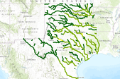
The SARP Flow Alteration Assessment provides a regional characterization of the distribution and risk of flow regime impairment of streams and rivers by anthropogenic sources at the NHD+ segment scale. This map illustrates the cumulative risk of flow alteration (RFA) from surface water use for thermopower generation in Oklahoma.  Water use is based on state permits for surface water withdrawals and returns.  The risk is based on the volume of water used monthly in the drainage area relative to the monthly volume of flow.  Risk of Flow Alteration categories:  ZERO     - 0% mean monthly flow depletion,  LOW      - > 0-10%,  MEDIUM - > 10-20%,  HIGH      - >20-100%, and  PROVISIONAL...
Geographic patterns and time trends of water-quality, modeled streamflow, and ecological data were compared along the Canadian River and selected tributaries in northeastern New Mexico to Lake Eufaula in Oklahoma to determine effects of climate change on water quality, streamflows, fish populations and ecological flows in this watershed from 1939 to 2013. Project participants included staff from the Oklahoma Cooperative Fish and Wildlife Research Unit, Vieux and Associates, USGS New Jersey Water Science Center and the USGS Oklahoma Water Science Center. Principal project funding was by the South Central Climate Science Center, with in-kind matching from the project participant organizations.

The SARP Flow Alteration Assessment provides a regional characterization of the distribution and risk of flow regime impairment of streams and rivers by anthropogenic sources at the NHD+ segment scale. This map illustrates the cumulative risk of flow alteration (RFA) from surface water use industrial water use in Texas and Oklahoma.  Water use is based on state permits for surface water withdrawals and returns.  The risk is based on the volume of water used monthly in the drainage area relative to the monthly volume of flow.  Risk of Flow Alteration categories:  ZERO     - 0% mean monthly flow depletion,  LOW      - > 0-10%,  MEDIUM - > 10-20%,  HIGH      - >20-100%, and Â...

The SARP River Classification Framework provides consistent categories of ecologically relevant attributes for streams and rivers across the region at the NHD+ segment scale. The attributes that are currently available include: 1) stream size: by basin area and mean annual flow; 2) gradient: by average segment slope; 3) EPA Level 3 Ecoregion; 4) TNC Freshwater Ecoregion; and 5) Ecological Drainage Units.  For more detailed information, go to the SIFN page on the SARP website at http://www.southeastaquatics.net/sarps-programs/sifn

The SARP Flow Alteration Assessment provides a regional characterization of the distribution and risk of flow regime impairment of streams and rivers by anthropogenic sources at the NHD+ segment scale. This map illustrates the local risk of flow alteration (RFA) from surface water use by water use sector for Texas and Oklahoma.  Water use is based on state permits for surface water withdrawals and returns.  The risk is based on the volume of water used monthly in the drainage area relative to the monthly volume of flow.  Risk of Flow Alteration categories:  ZERO     - 0% mean monthly flow depletion,  LOW      - > 0-10%,  MEDIUM - > 10-20%,  HIGH      - >20-100%, and  PROVISIONAL...

The SARP Flow Alteration Assessment provides a regional characterization of the distribution and risk of flow regime impairment of streams and rivers by anthropogenic sources at the NHD+ segment scale. This map illustrates the risk of flow alteration (RFA) due to evaporative loss from artificial water bodies in local catchments for the 14-state SARP region. Â The amount of water body surface is based on high resolution NHD and linked to NHD+ catchments. Â The risk is based on the percentage of the catchment land surface covered by artificial water bodies (100 x water body surface area / watershed surface area) Risk of flow alteration categories: Â Â Â Â Â Â Â Â Â ZERO -Â Â Â Â Â Â 0% land covered by artificial...
The SARP Flow Alteration Assessment provides a regional characterization of the distribution and risk of flow regime impairment of streams and rivers by anthropogenic sources at the NHD+ segment scale. This map illustrates the cumulative risk of flow alteration (RFA) from surface water use for mining in Texas and Oklahoma.  Water use is based on state permits for surface water withdrawals and returns.  The risk is based on the volume of water used monthly in the drainage area relative to the monthly volume of flow.  Risk of Flow Alteration categories:  ZERO     - 0% mean monthly flow depletion,  LOW      - > 0-10%,  MEDIUM - > 10-20%,  HIGH      - >20-100%, and  PROVISIONAL...

The SARP Flow Alteration Assessment provides a regional characterization of the distribution and risk of flow regime impairment of streams and rivers by anthropogenic sources at the NHD+ segment scale. This map illustrates the cumulative risk of flow alteration (RFA) from surface water use for domestic and livestock in Texas and Oklahoma.  Water use is based on state permits for surface water withdrawals and returns.  The risk is based on the volume of water used monthly in the drainage area relative to the monthly volume of flow.  Risk of Flow Alteration categories:  ZERO     - 0% mean monthly flow depletion,  LOW      - > 0-10%,  MEDIUM - > 10-20%,  HIGH      - >20-100%,...
The quantity of water that should be retained in streams and rivers for the benefit of fish during periods of water scarcity is a question of considerable interest to river managers and biologists. Although instream flow methodologies have existed since the 1970s, no single method has been widely accepted for use on large warm-water rivers because of their high species richness and generalized fish habitat use patterns. In this paper, we present an approach similar to instream flow incremental methodology, but which uses two-dimensional flow models and biomass estimates derived from multiple sites on two Colorado rivers for predicting the effect of discharge on adult standing stocks of two native fish species. Suitability...
Categories: Publication;
Types: Citation,
Journal Citation;
Tags: Instream flows,
River Research and Applications,
meso-habitat,
two-dimensional modelling

The SARP Flow Alteration Assessment provides a regional characterization of the distribution and risk of flow regime impairment of streams and rivers by anthropogenic sources at the NHD+ segment scale. This map illustrates the risk of flow alteration (RFA) from runoff from impervious surfaces in local catchments for the 14-state SARP region.  The amount of impervious surface is based on 2006 National Land Use/Land Cover dataset.  The risk is based on the percentage of the catchment land surface covered by impervious surfaces (100 x impervious surface area / watershed surface area: Risk of flow alteration categories:         ZERO -     0% land covered by impervious surface         LOW -Â...
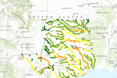
The SARP Flow Alteration Assessment provides a regional characterization of the distribution and risk of flow regime impairment of streams and rivers by anthropogenic sources at the NHD+ segment scale. This map illustrates the cumulative risk of flow alteration (RFA) from surface water use by water use sector for Texas and Oklahoma.  Water use is based on state permits for surface water withdrawals and returns.  The risk is based on the volume of water used monthly in the drainage area relative to the monthly volume of flow.Risk of Flow Alteration categories: ZERO     - 0% mean monthly flow depletion,  LOW      - > 0-10%,  MEDIUM - > 10-20%,  HIGH      - >20-100%, and PROVISIONAL...

The SARP Flow Alteration Assessment provides a regional characterization of the distribution and risk of flow regime impairment of streams and rivers by anthropogenic sources at the NHD+ segment scale. This map illustrates the cumulative risk of flow alteration (RFA) from surface water use for municipalities in Texas and Oklahoma.  Water use is based on state permits for surface water withdrawals and returns.  The risk is based on the volume of water used monthly in the drainage area relative to the monthly volume of flow.  Risk of Flow Alteration categories:  ZERO     - 0% mean monthly flow depletion,  LOW      - > 0-10%,  MEDIUM - > 10-20%,  HIGH      - >20-100%, and  PROVISIONAL...

A reservation of water for in-stream use is a water right that protects specific in-stream water uses, such as fish spawning or recreation. It sets aside the water necessary for these activities and keeps later water users from appropriating water that may affect the in-stream activity. This dataset includes those features that are represented by lines. This dataset includes additional information extracted from the Alaska Land Administration System by the Conservation Biology Institute. Water can be reserved for one or more permissible uses on a particular part of a stream or lake during a certain period of time. Under AS 46.15.145, permissible in-stream uses include: Protection of fish and wildlife habitat, migration,...

The SARP Flow Alteration Assessment provides a regional characterization of the distribution and risk of flow regime impairment of streams and rivers by anthropogenic sources at the NHD+ segment scale. This map illustrates the cumulative risk of flow alteration (RFA) from surface water use for irrigation in Texas and Oklahoma.  Water use is based on state permits for surface water withdrawals and returns.  The risk is based on the volume of water used monthly in the drainage area relative to the monthly volume of flow.  Risk of Flow Alteration categories:  ZERO     - 0% mean monthly flow depletion,  LOW      - > 0-10%,  MEDIUM - > 10-20%,  HIGH      - >20-100%, and  PROVISIONAL...

The SARP Flow Alteration Assessment provides a regional characterization of the distribution and risk of flow regime impairment by anthropogenic sources at the NHD+ segment scale. This map illustrates the annual risk of impacts to flow from evaporative loss from artificial waterbodies within the whole watershed. The cumulative risk is based on the percent of the land surface in the watershed covered by artificial water bodies (100 x water body surface area / watershed surface area) Risk categories:   ZERO -      0% land covered by artificial water bodies,                             LOW -      0-2%                            MEDIUM -Â...

A reservation of water for in-stream use is a water right that protects specific in-stream water uses, such as fish spawning or recreation. It sets aside the water necessary for these activities and keeps later water users from appropriating water that may affect the in-stream activity. This dataset includes those features that are represented by polygons. This dataset includes additional information extracted from the Alaska Land Administration System by the Conservation Biology Institute. Water can be reserved for one or more permissible uses on a particular part of a stream or lake during a certain period of time. Under AS 46.15.145, permissible in-stream uses include: Protection of fish and wildlife habitat,...

A reservation of water for in-stream use is a water right that protects specific in-stream water uses, such as fish spawning or recreation. It sets aside the water necessary for these activities and keeps later water users from appropriating water that may affect the in-stream activity. This dataset includes those features that are represented by points. This dataset includes additional information extracted from the Alaska Land Administration System by the Conservation Biology Institute. Water can be reserved for one or more permissible uses on a particular part of a stream or lake during a certain period of time. Under AS 46.15.145, permissible in-stream uses include: Protection of fish and wildlife habitat,...

The SARP Flow Alteration Assessment provides a regional characterization of the distribution and risk of flow regime impairment of streams and rivers by anthropogenic sources at the NHD+ segment scale. This map illustrates the cumulative risk of flow alteration (RFA) due to runoff from impervious surfaces for the 14-state SARP region. Â The amount of impervious surface is based on 2006 National Land Use/Land Cover dataset. Â The risk is based on the percentage of the catchment land surface covered by impervious surfaces (100 x impervious surface area / watershed surface area): Risk of flow alteration categories: Â Â Â Â Â Â Â Â Â Â Â Â Â Â Â Â Â Â Â Â Â Â Â Â Â Â Â ZERO -Â Â Â Â Â 0% land covered by impervious...
A reservation of water for in-stream use is a water right that protects specific in-stream water uses, such as fish spawning or recreation. It sets aside the water necessary for these activities and keeps later water users from appropriating water that may affect the in-stream activity. This dataset includes those features that are represented by polygons. This dataset includes additional information extracted from the Alaska Land Administration System by the Conservation Biology Institute. Water can be reserved for one or more permissible uses on a particular part of a stream or lake during a certain period of time. Under AS 46.15.145, permissible in-stream uses include: Protection of fish and wildlife habitat,...
|

|
