Filters: Tags: maxent (X) > partyWithName: Conservation Biology Institute (X)
100 results (86ms)|
Filters
Date Range
Tag Schemes |
The Nature Conservancy (TNC) has derived climate suitability forecasts for most species of trees and shrubs considered to be ecological dominants of terrestrial Californian habitat types. Our plant projections are compiled as decision support tools to help Conservancy project staff, as well as our external partners, develop the necessary plans, priorities and strategies to successfully adapt to uncertain changes in future climate. In the recently completed Southern Sierra Partnership's 2010 Climate-Adapted Conservation Plan for the Southern Sierra Nevada and Tehachapi Mountains, species and habitat forecasts shown here informed the development of a regional conservation design that explicitly incorporates long-term...

These data are statistical model outputs for appressed muhly (Muhlenbergia appressa) species distribution, completed by Frank Davisâ Biogeography Lab at UC Santa Barbara. The UCSB Biogeography Lab used Maxent to generate predictions of habitat occupancy for ~70 species for the CA Energy Commissionâs project âCumulative Biological Impacts Framework for Solar Energy in the CA Desertâ, 500-10-021. Species distribution models were produced at 270 m resolution using a subset of 22 environmental variables. Models were evaluated with 10-foldcross validated AUC scores. Results are preliminary and have notyet been reviewed by expert biologists. Both continuous probability surfaces and binary layers are available...
These data are statistical model outputs for Gila woodpecker (Melanerpes uropygialis) species distribution, completed by Frank Davisâ Biogeography Lab at UC Santa Barbara. The UCSB Biogeography Lab used Maxent to generate predictions of habitat occupancy for ~70 species for the CA Energy Commissionâs project âCumulative Biological Impacts Framework for Solar Energy in the CA Desertâ, 500-10-021. Species distribution models were produced at 270 m resolution using a subset of 22 environmental variables. Models were evaluated with 10-foldcross validated AUC scores. Results are preliminary and have notyet been reviewed by expert biologists. Both continuous probability surfaces and binary layers are available...

These data are statistical model outputs for Parry's spineflower (Chorizanthe parryi var parryi) species distribution, completed by Frank Davisâ Biogeography Lab at UC Santa Barbara. The UCSB Biogeography Lab used Maxent to generate predictions of habitat occupancy for ~70 species for the CA Energy Commissionâs project âCumulative Biological Impacts Framework for Solar Energy in the CA Desertâ, 500-10-021. Species distribution models were produced at 270 m resolution using a subset of 22 environmental variables. Models were evaluated with 10-foldcross validated AUC scores. Results are preliminary and have notyet been reviewed by expert biologists. Both continuous probability surfaces and binary layers are...

These data are statistical model outputs for red-diamond rattlesnake (Crotalus ruber) species distribution, completed by Frank Davisâ Biogeography Lab at UC Santa Barbara. The UCSB Biogeography Lab used Maxent to generate predictions of habitat occupancy for ~70 species for the CA Energy Commissionâs project âCumulative Biological Impacts Framework for Solar Energy in the CA Desertâ, 500-10-021. Species distribution models were produced at 270 m resolution using a subset of 22 environmental variables. Models were evaluated with 10-foldcross validated AUC scores. Results are preliminary and have notyet been reviewed by expert biologists. Both continuous probability surfaces and binary layers are available...

These data are statistical model outputs for scrub lotus (Acmispon argyraeus var multicaulis) species distribution, completed by Frank Davisâ Biogeography Lab at UC Santa Barbara. The UCSB Biogeography Lab used Maxent to generate predictions of habitat occupancy for ~70 species for the CA Energy Commissionâs project âCumulative Biological Impacts Framework for Solar Energy in the CA Desertâ, 500-10-021. Species distribution models were produced at 270 m resolution using a subset of 22 environmental variables. Models were evaluated with 10-foldcross validated AUC scores. Results are preliminary and have notyet been reviewed by expert biologists. Both continuous probability surfaces and binary layers are...

These data are statistical model outputs for American badger (Taxidea taxus) species distribution, completed by Frank Davisâ Biogeography Lab at UC Santa Barbara. The UCSB Biogeography Lab used Maxent to generate predictions of habitat occupancy for ~70 species for the CA Energy Commissionâs project âCumulative Biological Impacts Framework for Solar Energy in the CA Desertâ, 500-10-021. Species distribution models were produced at 270 m resolution using a subset of 22 environmental variables. Models were evaluated with 10-foldcross validated AUC scores. Results are preliminary and have notyet been reviewed by expert biologists. Both continuous probability surfaces and binary layers are available for each...

These data are statistical model outputs for desert pincushion (Coryphantha chlorantha) species distribution, completed by Frank Davisâ Biogeography Lab at UC Santa Barbara. The UCSB Biogeography Lab used Maxent to generate predictions of habitat occupancy for ~70 species for the CA Energy Commissionâs project âCumulative Biological Impacts Framework for Solar Energy in the CA Desertâ, 500-10-021. Species distribution models were produced at 270 m resolution using a subset of 22 environmental variables. Models were evaluated with 10-foldcross validated AUC scores. Results are preliminary and have notyet been reviewed by expert biologists. Both continuous probability surfaces and binary layers are available...

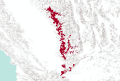
DRECP species distribution model output for Little San Bernardino Mtns. Linanthus (Linanthus maculatus ).Patrick McIntyre and Kara Moore of UC Davis generated predictions of rare plant habitat occupancy from Maxent models using an approach designed to maximize model ability to identify new occurrences in the field. A three-stage approach was used to build, assess, and finalize distribution models for focal taxa. First, the team built preliminary models at 270 m for each species. Second, field surveys were conducted based on preliminary model predictions. Third, final models were built based on all occurrences, including field data, and assessed for potential biases and model fit. Models were evaluated for their...

Percent perennial plant cover. The total perennial plant cover data were modeled using Moderate Resolution Imaging Spectroradiometer (MODIS) Enhanced Vegetation Index (EVI) collected by the MODIS satellite and composited over 16-day intervals (Wallace and others, 2008), combined with field measurements of total perennial cover, estimated from line intercept transects at locations across the Mojave Desert (Webb and others, 2003, 2009; Thomas and others, unpublished data; Wallace and others, 2008). Total perennial cover was related to elevation and 2001 through 2004 MODIS-EVI data at the transect locations (R2 = 0.82), and the resulting model was used to extrapolate cover estimates for the remaining study area. The...

The Nature Conservancy (TNC) has derived climate suitability forecasts for most species of trees and shrubs considered to be ecological dominants of terrestrial Californian habitat types. Our plant projections are compiled as decision support tools to help Conservancy project staff, as well as our external partners, develop the necessary plans, priorities and strategies to successfully adapt to uncertain changes in future climate. In the recently completed Southern Sierra Partnership's 2010 Climate-Adapted Conservation Plan for the Southern Sierra Nevada and Tehachapi Mountains, species and habitat forecasts shown here informed the development of a regional conservation design that explicitly incorporates long-term...

These data are statistical model outputs for Le Conte's thrasher (Toxostoma lecontei) species distribution, completed by Frank Davisâ Biogeography Lab at UC Santa Barbara. The UCSB Biogeography Lab used Maxent to generate predictions of habitat occupancy for ~70 species for the CA Energy Commissionâs project âCumulative Biological Impacts Framework for Solar Energy in the CA Desertâ, 500-10-021. Species distribution models were produced at 270 m resolution using a subset of 22 environmental variables. Models were evaluated with 10-foldcross validated AUC scores. Results are preliminary and have notyet been reviewed by expert biologists. Both continuous probability surfaces and binary layers are available...

These data are statistical model outputs for Alverson's foxtail cactus (Coryphantha alversonii) species distribution, completed by Frank Davisâ Biogeography Lab at UC Santa Barbara. The UCSB Biogeography Lab used Maxent to generate predictions of habitat occupancy for ~70 species for the CA Energy Commissionâs project âCumulative Biological Impacts Framework for Solar Energy in the CA Desertâ, 500-10-021. Species distribution models were produced at 270 m resolution using a subset of 22 environmental variables. Models were evaluated with 10-foldcross validated AUC scores. Results are preliminary and have notyet been reviewed by expert biologists. Both continuous probability surfaces and binary layers are...

These data are statistical model outputs for Barstow woolly sunflower (Eriophyllum mohavense) species distribution, completed by Frank Davisâ Biogeography Lab at UC Santa Barbara.. The UCSB Biogeography Lab used Maxent to generate predictions of habitat occupancy for ~70 species for the CA Energy Commissionâs project âCumulative Biological Impacts Framework for Solar Energy in the CA Desertâ, 500-10-021. Species distribution models were produced at 270 m resolution using a subset of 22 environmental variables. Models were evaluated with 10-foldcross validated AUC scores. Results are preliminary and have notyet been reviewed by expert biologists. Both continuous probability surfaces and binary layers are...

These data are statistical model outputs for spiny cliff-brake (Pellaea truncata) species distribution, completed by Frank Davisâ Biogeography Lab at UC Santa Barbara. The UCSB Biogeography Lab used Maxent to generate predictions of habitat occupancy for ~70 species for the CA Energy Commissionâs project âCumulative Biological Impacts Framework for Solar Energy in the CA Desertâ, 500-10-021. Species distribution models were produced at 270 m resolution using a subset of 22 environmental variables. Models were evaluated with 10-foldcross validated AUC scores. Results are preliminary and have notyet been reviewed by expert biologists. Both continuous probability surfaces and binary layers are available for...

These data are statistical model outputs for Barstow woolly sunflower (Eriophyllum mohavense) species distribution, completed by Frank Davisâ Biogeography Lab at UC Santa Barbara. The UCSB Biogeography Lab used Maxent to generate predictions of habitat occupancy for ~70 species for the CA Energy Commissionâs project âCumulative Biological Impacts Framework for Solar Energy in the CA Desertâ, 500-10-021. Species distribution models were produced at 270 m resolution using a subset of 22 environmental variables. Models were evaluated with 10-fold cross validated AUC scores. Binary layers depicting predicted suitable habitat were derived using the equal training sensitivity and specificity threshold. For...

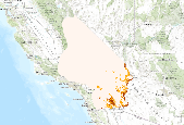
These data are statistical model outputs for Swainson's hawk (Buteo swainsoni ) species distribution, completed by Frank Davisâ Biogeography Lab at UC Santa Barbara. Based on examination of species observation data and consultation with biologists, CBI used the model's narrow extent output masked to the following USFS ecoregion subsections: 322Ag, 322Aa, 322Cc. The UCSB Biogeography Lab used Maxent to generate predictions of habitat occupancy for ~70 species for the CA Energy Commissionâs project âCumulative Biological Impacts Framework for Solar Energy in the CA Desertâ, 500-10-021. Species distribution models were produced at 270 m resolution using a subset of 22 environmental variables. Models were...

Average surface roughness. Surface roughness was calculated at a 30-m cell size using the method specified by Hobson (1972). Average surface roughness was then calculated as the average value of surface roughness in each 1-km2 grid cell. Derived from 30m NED DEM.

These data are statistical model outputs for merlin (Falco columbarius) species distribution, completed by Frank Davisâ Biogeography Lab at UC Santa Barbara. The UCSB Biogeography Lab used Maxent to generate predictions of habitat occupancy for ~70 species for the CA Energy Commissionâs project âCumulative Biological Impacts Framework for Solar Energy in the CA Desertâ, 500-10-021. Species distribution models were produced at 270 m resolution using a subset of 22 environmental variables. Models were evaluated with 10-foldcross validated AUC scores. Results are preliminary and have notyet been reviewed by expert biologists. Both continuous probability surfaces and binary layers are available for each species...

These data are statistical model outputs for Mojave monkeyflower (Mimulus mohavensis) species distribution, completed by Frank Davisâ Biogeography Lab at UC Santa Barbara. The UCSB Biogeography Lab used Maxent to generate predictions of habitat occupancy for ~70 species for the CA Energy Commissionâs project âCumulative Biological Impacts Framework for Solar Energy in the CA Desertâ, 500-10-021. Species distribution models were produced at 270 m resolution using a subset of 22 environmental variables. Models were evaluated with 10-foldcross validated AUC scores. Results are preliminary and have notyet been reviewed by expert biologists. Both continuous probability surfaces and binary layers are available...
|

|
