Filters: Tags: maxent (X)
258 results (99ms)|
Filters
Date Range
Extensions Types
Contacts
Categories Tag Types
|
This project used species distribution modeling, population genetics, and geospatial analysis of historical vs. modern vertebrate populations to identify climate change refugia and population connectivity across the Sierra Nevada. It is hypothesized that climate change refugia will increase persistence and stability of populations and, as a result, maintain higher genetic diversity. This work helps managers assess the need to include connectivity and refugia in climate change adaptation strategies. Results help Sierra Nevada land managers allocate limited resources, aid future scenario assessment at landscape scales, and develop a performance measure for assessing resilience.
Categories: Data,
Project;
Tags: 2011,
2013,
CA,
California Landscape Conservation Cooperative,
Conservation Design,
These data are statistical model outputs for California black rail (Laterallus jamaicensis coturniculus) species distribution, completed by Frank Davisâ Biogeography Lab at UC Santa Barbara. The UCSB Biogeography Lab used Maxent to generate predictions of habitat occupancy for ~70 species for the CA Energy Commissionâs project âCumulative Biological Impacts Framework for Solar Energy in the CA Desertâ, 500-10-021. Species distribution models were produced at 270 m resolution using a subset of 22 environmental variables. Models were evaluated with 10-foldcross validated AUC scores. Results are preliminary and have notyet been reviewed by expert biologists. Both continuous probability surfaces and binary...

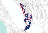
These data are statistical model outputs for Willow flycatcher (ssp. Southwestern willow flycatcher) (Empidonax traillii extimus )  species distribution, completed by Frank Davisâ Biogeography Lab at UC Santa Barbara. Based on examination of species observation data and consultation with biologists, CBI used the model's broad extent output masked to within 10 km of the Colorado River and the following USFS ecoregion subsections: 322Aa, M261Er, M261Es, 322Ag, M262Bi, M262Bh, M262Bg, 322Cc.  The UCSB Biogeography Lab used Maxent to generate predictions of habitat occupancy for ~70 species for the CA Energy Commissionâs project âCumulative Biological Impacts Framework for Solar Energy in the CA Desertâ,...

These data are statistical model outputs for pallid San Diego pocket mouse (Chaetodipus fallax pallidus) species distribution, completed by Frank Davisâ Biogeography Lab at UC Santa Barbara. The UCSB Biogeography Lab used Maxent to generate predictions of habitat occupancy for ~70 species for the CA Energy Commissionâs project âCumulative Biological Impacts Framework for Solar Energy in the CA Desertâ, 500-10-021. Species distribution models were produced at 270 m resolution using a subset of 22 environmental variables. Models were evaluated with 10-foldcross validated AUC scores. Results are preliminary and have notyet been reviewed by expert biologists. Both continuous probability surfaces and binary...

These data are statistical model outputs for prairie falcon (Falco mexicanus) species distribution, completed by Frank Davisâ Biogeography Lab at UC Santa Barbara. The UCSB Biogeography Lab used Maxent to generate predictions of habitat occupancy for ~70 species for the CA Energy Commissionâs project âCumulative Biological Impacts Framework for Solar Energy in the CA Desertâ, 500-10-021. Species distribution models were produced at 270 m resolution using a subset of 22 environmental variables. Models were evaluated with 10-foldcross validated AUC scores. Results are preliminary and have notyet been reviewed by expert biologists. Both continuous probability surfaces and binary layers are available for each...

These data are statistical model outputs for tricolored blackbird (Agelaius tricolor) species distribution, completed by Frank Davisâ Biogeography Lab at UC Santa Barbara. The UCSB Biogeography Lab used Maxent to generate predictions of habitat occupancy for ~70 species for the CA Energy Commissionâs project âCumulative Biological Impacts Framework for Solar Energy in the CA Desertâ, 500-10-021. Species distribution models were produced at 270 m resolution using a subset of 22 environmental variables. Models were evaluated with 10-foldcross validated AUC scores. Results are preliminary and have notyet been reviewed by expert biologists. Both continuous probability surfaces and binary layers are available...

These data are statistical model outputs for white-margined beardtongue (Penstemon albomarginatus) species distribution, completed by Frank Davisâ Biogeography Lab at UC Santa Barbara. The UCSB Biogeography Lab used Maxent to generate predictions of habitat occupancy for ~70 species for the CA Energy Commissionâs project âCumulative Biological Impacts Framework for Solar Energy in the CA Desertâ, 500-10-021. Species distribution models were produced at 270 m resolution using a subset of 22 environmental variables. Models were evaluated with 10-foldcross validated AUC scores. Results are preliminary and have notyet been reviewed by expert biologists. Both continuous probability surfaces and binary layers...

Annual growth potential is an environmental data layer that is a proxy for annual plant biomass, which reflects potential forage for tortoises. This data layer was derived by calculating the difference in greenness (a measure of plant growth) between two highly contrasting years of annual plant production (Wallace and Thomas, 2008). The difference between MODIS-EVI images for 2002 (a very dry year) and 2005 (a very wet year) had high correlation with field measurements of annual plant cover collected on 36 plots in the Mojave National Preserve in 2005 (R2 = 0.63, p=0.01). The resulting values represent the potential for site specific food availability for desert tortoise.

Percent smoothness. First, Surface roughness was calculated at a 30-m cell size using the method specified by Hobson (1972). Average surface roughness was calculated as the average value of surface roughness in each 1-km2 grid cell. Percent smooth. Percentage of each 1-km2 cell that was "smooth" and "rough" was assessed by measuring the proportion of 30-m average roughness grid cells that were < 1.01 (threshold for smooth). Derived from 30m NED DEM.

These data are statistical model outputs for Bendire's thrasher (Toxostoma bendirei ) species distribution, completed by Frank Davisâ Biogeography Lab at UC Santa Barbara. Based on examination of species observation data and consultation with biologists, CBI masked the model's broad extent output to the following USFS ecoregion subsections: 322Aj', '322Ak', '322Al', '322Ao', '322Am', '322An', 'M262Bi', '322Bc', '322Ba', '322Ah', '341Fe', '322Ab', '341Fe', 'M261Er', '322Cb', '322Cc', '322Ca', '322Cd', '322Bb', '322Ap'. The UCSB Biogeography Lab used Maxent to generate predictions of habitat occupancy for ~70 species for the CA Energy Commissionâs project âCumulative Biological Impacts Framework for Solar...

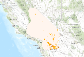
The Nature Conservancy (TNC) has derived climate suitability forecasts for most species of trees and shrubs considered to be ecological dominants of terrestrial Californian habitat types. Our plant projections are compiled as decision support tools to help Conservancy project staff, as well as our external partners, develop the necessary plans, priorities and strategies to successfully adapt to uncertain changes in future climate. In the recently completed Southern Sierra Partnership's 2010 Climate-Adapted Conservation Plan for the Southern Sierra Nevada and Tehachapi Mountains, species and habitat forecasts shown here informed the development of a regional conservation design that explicitly incorporates long-term...

The Nature Conservancy (TNC) has derived climate suitability forecasts for most species of trees and shrubs considered to be ecological dominants of terrestrial Californian habitat types. Our plant projections are compiled as decision support tools to help Conservancy project staff, as well as our external partners, develop the necessary plans, priorities and strategies to successfully adapt to uncertain changes in future climate. In the recently completed Southern Sierra Partnership's 2010 Climate-Adapted Conservation Plan for the Southern Sierra Nevada and Tehachapi Mountains, species and habitat forecasts shown here informed the development of a regional conservation design that explicitly incorporates long-term...

The Nature Conservancy (TNC) has derived climate suitability forecasts for most species of trees and shrubs considered to be ecological dominants of terrestrial Californian habitat types. Our plant projections are compiled as decision support tools to help Conservancy project staff, as well as our external partners, develop the necessary plans, priorities and strategies to successfully adapt to uncertain changes in future climate. In the recently completed Southern Sierra Partnership's 2010 Climate-Adapted Conservation Plan for the Southern Sierra Nevada and Tehachapi Mountains, species and habitat forecasts shown here informed the development of a regional conservation design that explicitly incorporates long-term...

The Nature Conservancy (TNC) has derived climate suitability forecasts for most species of trees and shrubs considered to be ecological dominants of terrestrial Californian habitat types. Our plant projections are compiled as decision support tools to help Conservancy project staff, as well as our external partners, develop the necessary plans, priorities and strategies to successfully adapt to uncertain changes in future climate. In the recently completed Southern Sierra Partnership's 2010 Climate-Adapted Conservation Plan for the Southern Sierra Nevada and Tehachapi Mountains, species and habitat forecasts shown here informed the development of a regional conservation design that explicitly incorporates long-term...
The Nature Conservancy (TNC) has derived climate suitability forecasts for most species of trees and shrubs considered to be ecological dominants of terrestrial Californian habitat types. Our plant projections are compiled as decision support tools to help Conservancy project staff, as well as our external partners, develop the necessary plans, priorities and strategies to successfully adapt to uncertain changes in future climate. In the recently completed Southern Sierra Partnership's 2010 Climate-Adapted Conservation Plan for the Southern Sierra Nevada and Tehachapi Mountains, species and habitat forecasts shown here informed the development of a regional conservation design that explicitly incorporates long-term...

The Nature Conservancy (TNC) has derived climate suitability forecasts for most species of trees and shrubs considered to be ecological dominants of terrestrial Californian habitat types. Our plant projections are compiled as decision support tools to help Conservancy project staff, as well as our external partners, develop the necessary plans, priorities and strategies to successfully adapt to uncertain changes in future climate. In the recently completed Southern Sierra Partnership's 2010 Climate-Adapted Conservation Plan for the Southern Sierra Nevada and Tehachapi Mountains, species and habitat forecasts shown here informed the development of a regional conservation design that explicitly incorporates long-term...

The Nature Conservancy (TNC) has derived climate suitability forecasts for most species of trees and shrubs considered to be ecological dominants of terrestrial Californian habitat types. Our plant projections are compiled as decision support tools to help Conservancy project staff, as well as our external partners, develop the necessary plans, priorities and strategies to successfully adapt to uncertain changes in future climate. In the recently completed Southern Sierra Partnership's 2010 Climate-Adapted Conservation Plan for the Southern Sierra Nevada and Tehachapi Mountains, species and habitat forecasts shown here informed the development of a regional conservation design that explicitly incorporates long-term...

The Nature Conservancy (TNC) has derived climate suitability forecasts for most species of trees and shrubs considered to be ecological dominants of terrestrial Californian habitat types. Our plant projections are compiled as decision support tools to help Conservancy project staff, as well as our external partners, develop the necessary plans, priorities and strategies to successfully adapt to uncertain changes in future climate. In the recently completed Southern Sierra Partnership's 2010 Climate-Adapted Conservation Plan for the Southern Sierra Nevada and Tehachapi Mountains, species and habitat forecasts shown here informed the development of a regional conservation design that explicitly incorporates long-term...

The Nature Conservancy (TNC) has derived climate suitability forecasts for most species of trees and shrubs considered to be ecological dominants of terrestrial Californian habitat types. Our plant projections are compiled as decision support tools to help Conservancy project staff, as well as our external partners, develop the necessary plans, priorities and strategies to successfully adapt to uncertain changes in future climate. In the recently completed Southern Sierra Partnership's 2010 Climate-Adapted Conservation Plan for the Southern Sierra Nevada and Tehachapi Mountains, species and habitat forecasts shown here informed the development of a regional conservation design that explicitly incorporates long-term...

The Nature Conservancy (TNC) has derived climate suitability forecasts for most species of trees and shrubs considered to be ecological dominants of terrestrial Californian habitat types. Our plant projections are compiled as decision support tools to help Conservancy project staff, as well as our external partners, develop the necessary plans, priorities and strategies to successfully adapt to uncertain changes in future climate. In the recently completed Southern Sierra Partnership's 2010 Climate-Adapted Conservation Plan for the Southern Sierra Nevada and Tehachapi Mountains, species and habitat forecasts shown here informed the development of a regional conservation design that explicitly incorporates long-term...
|

|
