Filters: Tags: municipal (X)
15 results (37ms)|
Filters
|

The SARP Flow Alteration Assessment provides a regional characterization of the distribution and risk of flow regime impairment of streams and rivers by anthropogenic sources at the NHD+ segment scale. This map illustrates the cumulative risk of flow alteration (RFA) from surface water use for thermopower generation in Oklahoma.  Water use is based on state permits for surface water withdrawals and returns.  The risk is based on the volume of water used monthly in the drainage area relative to the monthly volume of flow.  Risk of Flow Alteration categories:  ZERO     - 0% mean monthly flow depletion,  LOW      - > 0-10%,  MEDIUM - > 10-20%,  HIGH      - >20-100%, and  PROVISIONAL...

The SARP Flow Alteration Assessment provides a regional characterization of the distribution and risk of flow regime impairment of streams and rivers by anthropogenic sources at the NHD+ segment scale. This map illustrates the cumulative risk of flow alteration (RFA) from surface water use industrial water use in Texas and Oklahoma.  Water use is based on state permits for surface water withdrawals and returns.  The risk is based on the volume of water used monthly in the drainage area relative to the monthly volume of flow.  Risk of Flow Alteration categories:  ZERO     - 0% mean monthly flow depletion,  LOW      - > 0-10%,  MEDIUM - > 10-20%,  HIGH      - >20-100%, and Â...

The USGS Governmental Unit Boundaries service from The National Map (TNM) represents major civil areas for the Nation, including States or Territories, counties (or equivalents), Federal and Native American areas, congressional districts, minor civil divisions, incorporated places (such as cities and towns), and unincorporated places. Boundaries data are useful for understanding the extent of jurisdictional or administrative areas for a wide range of applications, including mapping or managing resources, and responding to natural disasters. Boundaries data also include extents of forest, grassland, park, wilderness, wildlife, and other reserve areas useful for recreational activities, such as hiking and backpacking....

The SARP Flow Alteration Assessment provides a regional characterization of the distribution and risk of flow regime impairment of streams and rivers by anthropogenic sources at the NHD+ segment scale. This map illustrates the local risk of flow alteration (RFA) from surface water use by water use sector for Texas and Oklahoma.  Water use is based on state permits for surface water withdrawals and returns.  The risk is based on the volume of water used monthly in the drainage area relative to the monthly volume of flow.  Risk of Flow Alteration categories:  ZERO     - 0% mean monthly flow depletion,  LOW      - > 0-10%,  MEDIUM - > 10-20%,  HIGH      - >20-100%, and  PROVISIONAL...
This collection contains maps and notes with information on state boundaries with New York and Delaware as well as some municipal and county boundaries.
Categories: Data;
Types: Map Service,
OGC WFS Layer,
OGC WMS Layer,
OGC WMS Service;
Tags: Aerial photographs,
Boundary,
County,
Delaware,
Geological Collection,
The SARP Flow Alteration Assessment provides a regional characterization of the distribution and risk of flow regime impairment of streams and rivers by anthropogenic sources at the NHD+ segment scale. This map illustrates the cumulative risk of flow alteration (RFA) from surface water use for mining in Texas and Oklahoma.  Water use is based on state permits for surface water withdrawals and returns.  The risk is based on the volume of water used monthly in the drainage area relative to the monthly volume of flow.  Risk of Flow Alteration categories:  ZERO     - 0% mean monthly flow depletion,  LOW      - > 0-10%,  MEDIUM - > 10-20%,  HIGH      - >20-100%, and  PROVISIONAL...

The SARP Flow Alteration Assessment provides a regional characterization of the distribution and risk of flow regime impairment of streams and rivers by anthropogenic sources at the NHD+ segment scale. This map illustrates the cumulative risk of flow alteration (RFA) from surface water use for domestic and livestock in Texas and Oklahoma.  Water use is based on state permits for surface water withdrawals and returns.  The risk is based on the volume of water used monthly in the drainage area relative to the monthly volume of flow.  Risk of Flow Alteration categories:  ZERO     - 0% mean monthly flow depletion,  LOW      - > 0-10%,  MEDIUM - > 10-20%,  HIGH      - >20-100%,...
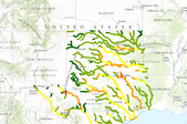
The SARP Flow Alteration Assessment provides a regional characterization of the distribution and risk of flow regime impairment of streams and rivers by anthropogenic sources at the NHD+ segment scale. This map illustrates the cumulative risk of flow alteration (RFA) from surface water use by water use sector for Texas and Oklahoma.  Water use is based on state permits for surface water withdrawals and returns.  The risk is based on the volume of water used monthly in the drainage area relative to the monthly volume of flow.Risk of Flow Alteration categories: ZERO     - 0% mean monthly flow depletion,  LOW      - > 0-10%,  MEDIUM - > 10-20%,  HIGH      - >20-100%, and PROVISIONAL...

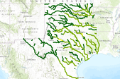
The SARP Flow Alteration Assessment provides a regional characterization of the distribution and risk of flow regime impairment of streams and rivers by anthropogenic sources at the NHD+ segment scale. This map illustrates the cumulative risk of flow alteration (RFA) from surface water use for municipalities in Texas and Oklahoma.  Water use is based on state permits for surface water withdrawals and returns.  The risk is based on the volume of water used monthly in the drainage area relative to the monthly volume of flow.  Risk of Flow Alteration categories:  ZERO     - 0% mean monthly flow depletion,  LOW      - > 0-10%,  MEDIUM - > 10-20%,  HIGH      - >20-100%, and  PROVISIONAL...
Based on the practical experience in design and operation of three full-scale membrane bioreactors (MBR) for municipal wastewater treatment that were commissioned since 1999, an overview on the different design concepts that were applied to the three MBR plants is given. The investment costs and the energy consumption of the MBRs and conventional activated sludge (CAS) plants (with and without tertiary treatment) in the Erft river region are compared. It is found that the specific investment costs of the MBR plants are lower than those of comparable CAS with tertiary treatment. A comparison of the specific energy demand of MBRs and conventional WWTPs is given. The structure of the MBRs actual operational costs is...
Categories: Publication;
Types: Citation;
Tags: Considerations,
applications,
bioreactors,
design,
feasibility,
Taxing Entities consist of a group of people who organize to tax themselves for specific purposes. These may include, but are not limited to: improvement and service districts for repairing or replacing a local road; water and sewer to provide infrastructure to a rural area for water and sewer facilities; conservation districts to help protect natural resources; and fire to provide fire protection services to rural areas, etc.
Categories: Data;
Types: Downloadable;
Tags: Boundaries,
Cities,
Counties,
Municipal,
Municipalities,
The USGS Governmental Unit Boundaries service from The National Map (TNM) represents major civil areas for the Nation, including States or Territories, counties (or equivalents), Federal and Native American areas, congressional districts, minor civil divisions, incorporated places (such as cities and towns), and unincorporated places. Boundaries data are useful for understanding the extent of jurisdictional or administrative areas for a wide range of applications, including mapping or managing resources, and responding to natural disasters. Boundaries data also include extents of forest, grassland, park, wilderness, wildlife, and other reserve areas useful for recreational activities, such as hiking and backpacking....
Categories: Data;
Types: ArcGIS REST Map Service,
Map Service;
Tags: Boundaries,
Governmental Units, and Administrative and Statistical Boundaries,
NGP-TNM,
Overlay Map Service,
REST,
Internet map viewer that displays WyGISC spatial data for Wyoming. The WyGISC Data Server was updated in July, 2010 - and specifically provides clip and zip functionality for basic data layers for Wyoming, as well as WyGISC-developed data.

The SARP Flow Alteration Assessment provides a regional characterization of the distribution and risk of flow regime impairment of streams and rivers by anthropogenic sources at the NHD+ segment scale. This map illustrates the cumulative risk of flow alteration (RFA) from surface water use for irrigation in Texas and Oklahoma.  Water use is based on state permits for surface water withdrawals and returns.  The risk is based on the volume of water used monthly in the drainage area relative to the monthly volume of flow.  Risk of Flow Alteration categories:  ZERO     - 0% mean monthly flow depletion,  LOW      - > 0-10%,  MEDIUM - > 10-20%,  HIGH      - >20-100%, and  PROVISIONAL...

Municipal Boundaries for Wyoming Taxing Entities consist of a group of people who organize to tax themselves for specific purposes. These may include, but are not limited to : improvement and service districts for repairing or replacing a local road; water and sewer to provide infrastructure to a rural area for water and sewer facilities; conservation districts to help protect natural resources; and fire to provide fire protection services to rural areas, etc.
|

|
