Filters: Tags: national (X)
108 results (58ms)|
Filters
Date Range
Extensions
Types
Contacts
Categories Tag Types
|

This map layer consists of federally owned or administered lands of the United States, Puerto Rico, and the U.S. Virgin Islands. For the most part, only areas of 320 acres or more are included; some smaller areas deemed to be important or significant are also included. There may be private inholdings within the boundaries of Federal lands in this map layer. Some established Federal lands which are larger than 320 acres are not included in this map layer, because their boundaries were not available from the owning or administering agency.

This map layer shows Indian lands of the United States. For the most part, only areas of 320 acres or more are included; some smaller areas deemed to be important or significant are also included. Federally-administered lands within a reservation are included for continuity; these may or may not be considered part of the reservation and are simply described with their feature type and the administrating Federal agency. Some established Indian lands which are larger than 320 acres are not included in this map layer because their boundaries were not available from the owning or administering agency.

The Geographic Names Information System (GNIS) is the Federal standard for geographic nomenclature. The U.S. Geological Survey developed the GNIS for the U.S. Board on Geographic Names, a Federal inter-agency body chartered by public law to maintain uniform feature name usage throughout the Government and to promulgate standard names to the public. The GNIS is the official repository of domestic geographic names data; the official vehicle for geographic names use by all departments of the Federal Government; and the source for applying geographic names to Federal electronic and printed products of all types.
Conclusions:Report synthesizes scientific, planning, and policy-related aspects on the importance of land conservation in areas producing water for potable uses, including watersheds and aquifers. One critical finding indicated that if there is more forest cover in a watershed, water treatment costs are lower.Thresholds/Learnings:For every 10% increase in forest cover in the source area, treatment and chemical costs decreased by about 20%, up to about 60% forest cover. Treatment costs level off when forest cover is between 70-100%.
Categories: Publication;
Types: Citation;
Tags: Land use configuration,
Natural cover amount,
United States,
forest cover,
multiple,
In 1998, the Florida Fish and Wildlife Conservation Commission's (FWC) Fisheries Independent Monitoring (FIM) program began a long-term monitoring effort of key reef fish populations in the Florida Keys National Marine Sanctuary. This effort was aimed at evaluating the relative abundance, size structure, and habitat utilization of specific reef fish species that are targeted by commercial and recreational fisheries.; Smith, S.G., et al. 2011, Multispecies survey design for assessing reef-fish stocks, spatially explicit management performance, and ecosystem condition. Fisheries Research 109(2011)25-41; Brandt, M.E., et. al. 2009, A Cooperative Multi-agency Reef Fish Monitoring Protocol for the Florida Keys Coral...
Categories: Data;
Types: NetCDF OPeNDAP Service;
Tags: Florida Keys National Marine Sanctuaries Reef Fish Monitoring,
array,
array-data,
basis,
basisOfRecord,
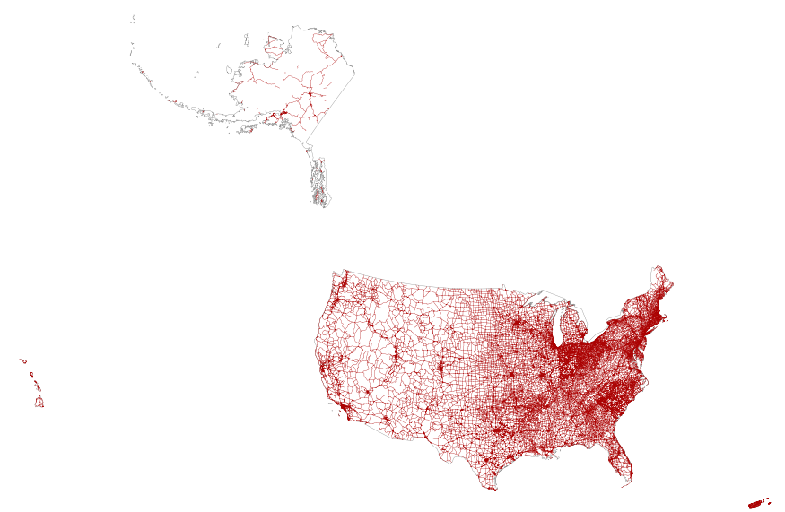
This map layer portrays the major roads in the United States, Puerto Rico, and the U.S. Virgin Islands. The file was produced by joining the individual State roads layers from the National Highway Planning Network (NHPN), Geographic Data Technology (GDT) Dynamap, and TIGER/Line files. This is a revised version of the July 2012 map layer.
This feature class includes monitoring data collected nationally to understand the status, condition, and trend of resources on BLM lands. Data are collected in accordance with the BLM Assessment, Inventory, and Monitoring (AIM) Strategy. The AIM Strategy specifies a probabilistic sampling design, standard core indicators and methods, electronic data capture and management, and integration with remote sensing. Attributes include the BLM aquatic core indicators: pH, conductivity, temperature, pool depth, length, frequency, streambed particles sizes, bank stability and cover, floodplain connectivity, large woody debris, macroinvertebrate biological integrity, ocular estimates of vegetative type, cover, and structure...
In 1998, the Florida Fish and Wildlife Conservation Commission's (FWC) Fisheries Independent Monitoring (FIM) program began a long-term monitoring effort of key reef fish populations in the Florida Keys National Marine Sanctuary. This effort was aimed at evaluating the relative abundance, size structure, and habitat utilization of specific reef fish species that are targeted by commercial and recreational fisheries.; Smith, S.G., et al. 2011, Multispecies survey design for assessing reef-fish stocks, spatially explicit management performance, and ecosystem condition. Fisheries Research 109(2011)25-41; Brandt, M.E., et. al. 2009, A Cooperative Multi-agency Reef Fish Monitoring Protocol for the Florida Keys Coral...
Categories: Data;
Types: NetCDF OPeNDAP Service;
Tags: Florida Keys National Marine Sanctuaries Reef Fish Monitoring,
array,
array-data,
basis,
basisOfRecord,
Background A major focus of the NAWQA Program in its second decade (2002-2013) is on regional- and national-scale assessments of groundwater-quality status and trends in principal aquifers. The U.S. Geological Survey Office of Groundwater has identified 62 principal aquifers in the U.S. ( U.S. Geological Survey, 2003 ). About 1/3 of the Nation's principal aquifers are the focus of water-quality assessments at the regional scale by NAWQA. The NAWQA framework for principal aquifer assessments considers the physical setting of the aquifer, in addition to its susceptibility and vulnerability to contamination. More information (USGS Fact Sheet 2005-3013, PDF, Adobe reader is freely available to read a PDF) Publications...
Categories: Data,
Project;
Types: Downloadable,
Map Service,
OGC WFS Layer,
OGC WMS Layer,
Shapefile;
Tags: Completed,
Focused Assessments,
Focused Assessments,
Focused Assessments,
Groundwater-Quality Monitoring,
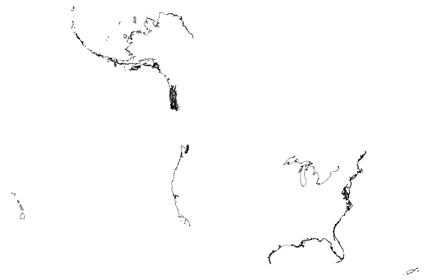
This map layer portrays the coastline of the United States, Puerto Rico, and the U.S. Virgin Islands. The United States shoreline of the Great Lakes is also included. This is a revised version of the July 2012 map layer.
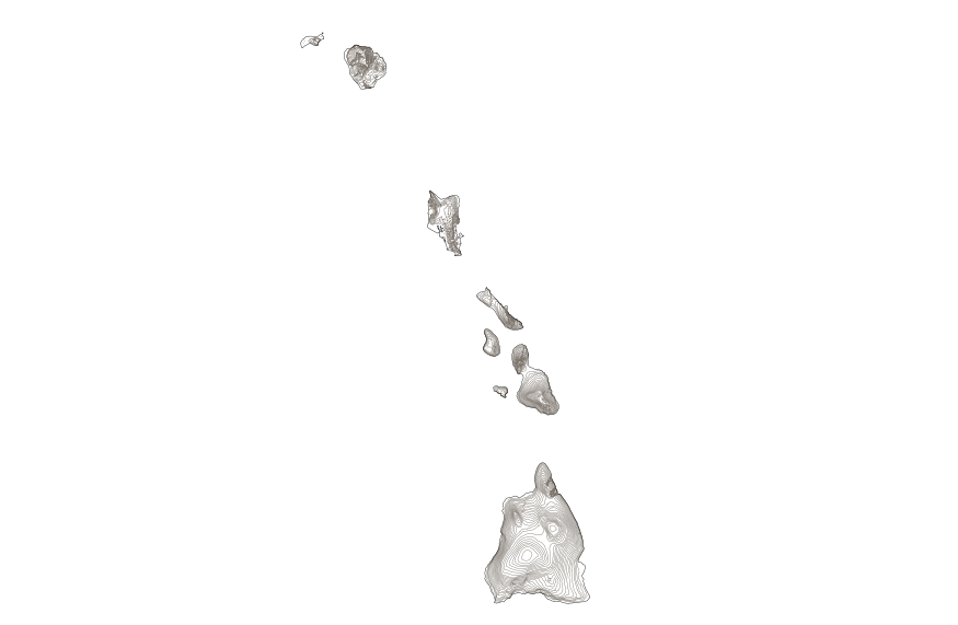
This map layer shows elevation contour lines for Hawaii. The map layer was derived from the 100-meter resolution elevation data set which is published by the National Atlas of the United States, and is in the same Albers Equal-area Conic projection as that source data set. Contour intervals match the steps used in the National Atlas Color-Sliced Elevation data sets. Contours were adjusted so that they are in the proper relationship to National Atlas 1:1,000,000-scale lakes, reservoirs, and wide (double-line) streams.
The major part of the Netherlands consists of a low-lying river delta which is very sensitive to hydrological conditions in the North-Western part of the European continent. The rivers Rhine, Meuse and Scheldt carry through this delta to the North Sea annually nearly 100 km3 of fresh water. This water originates from a drainage basin of about 185 000 km2, which is 6 times the country area. The present geography of the Netherlands has largely been shaped by this river inflow and by the sediments which are carried along. Interaction of these fluxes with North Sea hydrodynamics in a period of rising sea level has produced large lowlands, which in the past millennium have been reclaimed for agricultural, urban and industrial...
Categories: Publication;
Types: Citation;
Tags: Assessment,
National,
climate change,
instruments,
policy,
In 1998, the Florida Fish and Wildlife Conservation Commission's (FWC) Fisheries Independent Monitoring (FIM) program began a long-term monitoring effort of key reef fish populations in the Florida Keys National Marine Sanctuary. This effort was aimed at evaluating the relative abundance, size structure, and habitat utilization of specific reef fish species that are targeted by commercial and recreational fisheries.; Smith, S.G., et al. 2011, Multispecies survey design for assessing reef-fish stocks, spatially explicit management performance, and ecosystem condition. Fisheries Research 109(2011)25-41; Brandt, M.E., et. al. 2009, A Cooperative Multi-agency Reef Fish Monitoring Protocol for the Florida Keys Coral...
Categories: Data;
Types: NetCDF OPeNDAP Service;
Tags: Florida Keys National Marine Sanctuaries Reef Fish Monitoring,
array,
array-data,
basis,
basisOfRecord,
In 1998, the Florida Fish and Wildlife Conservation Commission's (FWC) Fisheries Independent Monitoring (FIM) program began a long-term monitoring effort of key reef fish populations in the Florida Keys National Marine Sanctuary. This effort was aimed at evaluating the relative abundance, size structure, and habitat utilization of specific reef fish species that are targeted by commercial and recreational fisheries. The data may be used and redistributed for free but is not intended for legal use, since it may contain inaccuracies. Neither the data Contributor, ERD, NOAA, nor the United States Government, nor any of their employees or contractors, makes any warranty, express or implied, including warranties...
Categories: Data;
Types: NetCDF OPeNDAP Service;
Tags: Florida Keys National Marine Sanctuaries Reef Fish Monitoring,
array,
array-data,
basis,
basisOfRecord,
In 1998, the Florida Fish and Wildlife Conservation Commission's (FWC) Fisheries Independent Monitoring (FIM) program began a long-term monitoring effort of key reef fish populations in the Florida Keys National Marine Sanctuary. This effort was aimed at evaluating the relative abundance, size structure, and habitat utilization of specific reef fish species that are targeted by commercial and recreational fisheries.; Smith, S.G., et al. 2011, Multispecies survey design for assessing reef-fish stocks, spatially explicit management performance, and ecosystem condition. Fisheries Research 109(2011)25-41; Brandt, M.E., et. al. 2009, A Cooperative Multi-agency Reef Fish Monitoring Protocol for the Florida Keys Coral...
Categories: Data;
Types: NetCDF OPeNDAP Service;
Tags: Florida Keys National Marine Sanctuaries Reef Fish Monitoring,
array,
array-data,
basis,
basisOfRecord,
Geospatial data that is a derivative land cover product depicting woodland on topographic maps.
This data provides locations and technical specifications of legacy and current versions of the United States Wind Turbines database. Almost all of which are utility-scale. Utility-scale turbines are ones that generate power and feed it into the grid, supplying a utility with energy. They are usually much larger than turbines that would feed a homeowner or business. Each release, typically done quarterly, updates the database with newly installed wind turbines, removes wind turbines that have been identified as dismantled, and applies other verifications based on updated imagery and ongoing quality-control. Turbine data were gathered from the Federal Aviation Administration's (FAA) Digital Obstacle File (DOF)...
Categories: Data;
Types: ArcGIS REST Map Service,
Map Service;
Tags: ACP,
American Clean Power,
LBNL,
USGS,
USGS Science Data Catalog (SDC),
|

|
