Filters: Tags: national (X)
123 results (167ms)|
Filters
Date Range
Extensions
Types
Contacts
Categories Tag Types Tag Schemes
|

Geospatial data includes structures and other selected map features.
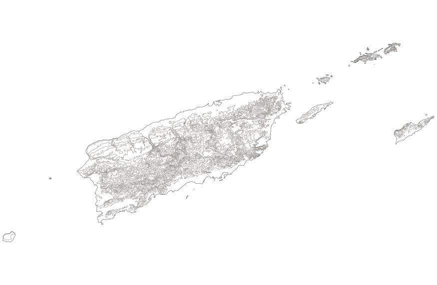
This map layer shows elevation contour lines for Puerto Rico and the U.S. Virgin Islands. The map layer was derived from the 100-meter resolution elevation data set which is published by the National Atlas of the United States, and is in the same Albers Equal-area Conic projection as that source data set. Contour intervals match the steps used in the National Atlas Color-Sliced Elevation data sets. Contours were adjusted so that they are in the proper relationship to National Atlas 1:1,000,000-scale lakes, reservoirs, and wide (double-line) streams.

This geodatabase contains streams, waterbodies and wetlands, streamflow gaging stations, and coastlines for the United States, Puerto Rico, and the U.S. Virgin Islands. The streams are incorporated into a geometric network. All feature classes are vertically integrated with each other and with 1:1,000,000-scale transportation and boundary data sets.
Data represents segments of the National Wild and Scenic River System. This is a national dataset that was clipped by WyGISC to the Wyoming Boundaries, additionally a web link to additional river data was included
This paper reviews the current energy supply and consumption. Worldwide, there was an increase in the annual energy consumption of 5% between 1955 and 1973 and of 2.7% between 1973 and 1979, but there was a decrease of 0.2% from 1 979 to 1983. The role of oil grew from 31% to 47% of world energy consumption between 1955 and 1973 but dropped to 40.3o/0 in 1983. Despite an overall decline in energy consumption in the last few years, the consumption of electricity continues to grow. Nuclear energy has not completely recovered from the crisis of the second half of the 1970's. This is in part because of social acceptance factors and hostility to large plants. World energy problems will continue over the next 20 years....
Categories: Publication;
Types: Citation;
Tags: Evaluating,
Strategic planning,
energy,
environmental,
impact,
In 1998, the Florida Fish and Wildlife Conservation Commission's (FWC) Fisheries Independent Monitoring (FIM) program began a long-term monitoring effort of key reef fish populations in the Florida Keys National Marine Sanctuary. This effort was aimed at evaluating the relative abundance, size structure, and habitat utilization of specific reef fish species that are targeted by commercial and recreational fisheries. The data may be used and redistributed for free but is not intended for legal use, since it may contain inaccuracies. Neither the data Contributor, ERD, NOAA, nor the United States Government, nor any of their employees or contractors, makes any warranty, express or implied, including warranties...
Categories: Data;
Types: NetCDF OPeNDAP Service;
Tags: Florida Keys National Marine Sanctuaries Reef Fish Monitoring,
array,
array-data,
basis,
basisOfRecord,

This data represents the map extent for current and historical USGS topographic maps for the United States and Territories, including 1 X 2 Degree, 1 X 1 Degree, 30 X 60 Minute, 15 X 15 Minute, 7.5 X 7.5 Minute, and 3.75 X 3.75 Minute. The grid was generated using ESRI ArcInfo GIS software.
This data provides locations and technical specifications of the current version of the United States Wind Turbines database. Each release, typically done quarterly, updates the database with newly installed wind turbines, removes wind turbines that have been identified as dismantled, and applies other verifications based on updated imagery and ongoing quality-control. Turbine data were gathered from the Federal Aviation Administration's (FAA) Digital Obstacle File (DOF) and Obstruction Evaluation Airport Airspace Analysis (OE-AAA), the American Clean Power Association (ACP), Lawrence Berkeley National Laboratory (LBNL), and the United States Geological Survey (USGS), and were merged and collapsed into a single...
Categories: Data;
Types: ArcGIS REST Map Service,
Downloadable,
Map Service,
OGC WFS Layer,
OGC WMS Layer,
Shapefile;
Tags: ACP,
LBNL,
USGS,
USWTDB,
database,
Layers of geospatial data include roads, airports, trails, and railroads.
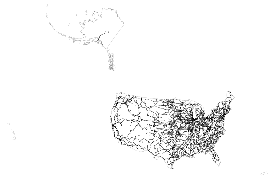
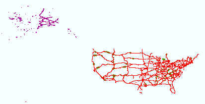
This map layer includes railroads in the conterminous United States and Alaska. This is a revised version of the July 2012 map layer.
This paper examines the attitudes and perceptions of 277 American Indians about hunting and fishing, risk, and future land use of the Idaho National Engineering and Environmental Laboratory (INEEL) in southeastern Idaho. Nearly half of our sample were Shoshone-Bannock tribal members living on the nearby Fort Hall Reservation, and half were American Indians from elsewhere in the western United States. We also interviewed an additional 44 White people. We examine the hypothesis that there are differences in environmental concerns and attitudes toward future land use at INEEL as a function of tribal affiliation (ethnicity), educational level, gender, and age. Such perceptions are important because of the existence...
Categories: Publication;
Types: Citation;
Tags: American Indians,
Attitudes,
Engineering,
Environmental,
Idaho,
This map shows climate parameters and MAPSS biogeography model data for the western US from PRISM (1968-1999), and future climate projections from the regional climate model RegCM3 using ECHAM5, GENMOM, and GFDL projections as boundary conditions for 2015-2030, and 2045-2060. These data are provided by Bureau of Land Management (BLM) "as is" and may contain errors or omissions. The User assumes the entire risk associated with its use of these data and bears all responsibility in determining whether these data are fit for the User's intended use. These data may not have the accuracy, resolution, completeness, timeliness, or other characteristics appropriate for applications that potential users of the data may contemplate....
In 1998, the Florida Fish and Wildlife Conservation Commission's (FWC) Fisheries Independent Monitoring (FIM) program began a long-term monitoring effort of key reef fish populations in the Florida Keys National Marine Sanctuary. This effort was aimed at evaluating the relative abundance, size structure, and habitat utilization of specific reef fish species that are targeted by commercial and recreational fisheries.; Smith, S.G., et al. 2011, Multispecies survey design for assessing reef-fish stocks, spatially explicit management performance, and ecosystem condition. Fisheries Research 109(2011)25-41; Brandt, M.E., et. al. 2009, A Cooperative Multi-agency Reef Fish Monitoring Protocol for the Florida Keys Coral...
Categories: Data;
Types: NetCDF OPeNDAP Service;
Tags: Florida Keys National Marine Sanctuaries Reef Fish Monitoring,
array,
array-data,
basis,
basisOfRecord,
The Geographic Names Information System (GNIS) is the Federal standard for geographic nomenclature. The U.S. Geological Survey developed the GNIS for the U.S. Board on Geographic Names, a Federal inter-agency body chartered by public law to maintain uniform feature name usage throughout the Government and to promulgate standard names to the public. The GNIS is the official repository of domestic geographic names data; the official vehicle for geographic names use by all departments of the Federal Government; and the source for applying geographic names to Federal electronic and printed products of all types. See http://geonames.usgs.gov for additional information.

This map layer includes railroads in the conterminous United States and Alaska. This is a revised version of the July 2012 map layer.
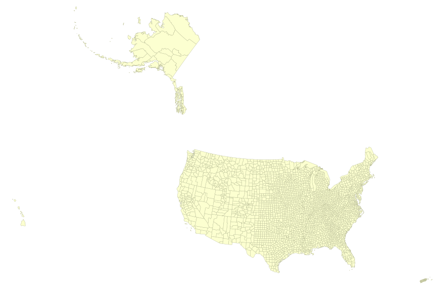
USGS Small-scale Dataset - 1:1,000,000-Scale County Boundaries of the United States 201403 Shapefile
This map layer portrays the county boundaries of the United States, Puerto Rico, and the U.S. Virgin Islands, by showing the counties as areas. The map layer was created by extracting county polygon features from the CENSUS 2006 TIGER/Line files produced by the U.S. Census Bureau. These files were then merged into a single file. This is a revised version of the July 2012 map layer.

This map layer portrays the county boundaries of the United States, Puerto Rico, and the U.S. Virgin Islands, by showing the counties as areas. The map layer was created by extracting county polygon features from the CENSUS 2006 TIGER/Line files produced by the U.S. Census Bureau. These files were then merged into a single file. This is a revised version of the July 2012 map layer.
There is no shortage of U.S. energy policy studies, analyses and recommendations. Each new U.S. administration' and many state govemments seek to develop their own energy policy approach, and yet over time, it seems as if little progress actually is made toward achieving stated energy policy objectives. As an example, consider the following conclusions from a key report. Throughout this decade, oil will remain the single most important commercial fuel, while such other primary and secondary energy sources as natural gas, coal, nuclear power, electricity, and energy from renewable sources must be relied upon increasingly.
Categories: Publication;
Types: Citation;
Tags: International,
U.S.,
economic,
energy,
interdependency,

This map layer consists of federally owned or administered lands of the United States, Puerto Rico, and the U.S. Virgin Islands. For the most part, only areas of 320 acres or more are included; some smaller areas deemed to be important or significant are also included. There may be private inholdings within the boundaries of Federal lands in this map layer. Some established Federal lands which are larger than 320 acres are not included in this map layer, because their boundaries were not available from the owning or administering agency.
|

|
