Filters: Tags: nawqa (X)
397 results (41ms)|
Filters
Date Range
Extensions Types
Contacts
Categories Tag Types Tag Schemes |
The Lithologic Logs dataset includes state well records, and the well logs were standardized so that the lithologic information used a consistent terminology by Bayless and others (2017). The dataset contains 1,565,051 records, of which 746,568 are for wells that are used for withdrawing water.
Continuous monitoring and discrete water-quality sampling were coupled in a karst aquifer to assess drivers and timescales of water-quality change. Water-quality data included environmental tracers of groundwater age (tritium [3H], tritiogenic helium-3 [3He-trit], sulfur hexafluoride [SF6], carbon-14 [14C], and radiogenic helium-4 [4He-rad]). All water quality data is available from the U.S. Geological Survey NWIS database (U.S. Geological Survey, 2019). Groundwater ages were estimated by calibration of environmental tracers to lumped parameter models of groundwater age for multiple samples collected at six groundwater wells using the program TracerLPM (Jurgens and others, 2012). The final estimates for mean groundwater...
Groundwater age is an important indicator of groundwater susceptibility to anthropogenic contamination and a key input to statistical models for forecasting water quality. Numerical models can provide estimates of groundwater age, enabling interpretation of measured age tracers. However, to extend to national-scale groundwater systems where numerical models are not routinely available, a more efficient metamodeling approach can provide a less precise but widely applicable estimate of groundwater age, trained to make forecasts based on predictor variables that can be measured independent of numerical models. We trained gradient-boosted regression tree statistical metamodels to MODFLOW/MODPATH derived groundwater...
A boosted regression tree (BRT) model was developed to predict pH conditions in three-dimensions throughout the glacial aquifer system (GLAC) of the contiguous United States using pH measurements in samples from 18,258 wells and predictor variables that represent aspects of the hydrogeologic setting. Model results indicate that the carbonate content of soils and aquifer materials strongly controls pH and when coupled with long flow paths, results in the most alkaline conditions. Conversely, in areas where glacial sediments are thin and carbonate-poor, pH conditions remain acidic. At depths typical of drinking-water supplies, predicted pH > 7.5 – which is associated with arsenic mobilization – occurs more frequently...
Categories: Data;
Types: Map Service,
OGC WFS Layer,
OGC WMS Layer,
OGC WMS Service;
Tags: Boosted regression trees,
Calcite saturation index,
Connecticut,
Geochemistry,
Geochemistry,

These data were released prior to the October 1, 2016 effective date for the USGS’s policy dictating the review, approval, and release of scientific data as referenced in USGS Survey Manual Chapter 502.8 Fundamental Science Practices: Review and Approval of Scientific Data for Release. This dataset consists of four national 1-kilometer (km) resolution rasters of the estimated percent presence of the soil restrictive layer (SRL) in the upper 25, 35, 45, and 55 centimeters of agricultural land. These rasters were developed from selected criteria of soil parameters from the Soil Survey Geographical (SSURGO) database and mapped agricultural land from the National Land Cover Database 2001 (NLCD 2001), version 2.

These data were released prior to the October 1, 2016 effective date for the USGS’s policy dictating the review, approval, and release of scientific data as referenced in USGS Survey Manual Chapter 502.8 Fundamental Science Practices: Review and Approval of Scientific Data for Release. This 30-meter data set represents land use and land cover for the conterminous United States for the 2001 time period. The data have been arranged into four tiles to facilitate timely display and manipulation within a Geographic Information System (see https://www.sciencebase.gov/catalog/file/get/631405cad34e36012efa3299?name=nlcd01-partitions.jpg). The National Land Cover Data Set for 2001 was produced through a cooperative project...

These data were released prior to the October 1, 2016 effective date for the USGS’s policy dictating the review, approval, and release of scientific data as referenced in USGS Survey Manual Chapter 502.8 Fundamental Science Practices: Review and Approval of Scientific Data for Release. This spatial data set was created by the U.S. Geological Survey (USGS) to represent mean annual solar radiation in the Pacific Northwest region of the United States (Hydro Region 17; Major River Basin 7 (MRB7)) for the period between 1991 and 2005.

These data were released prior to the October 1, 2016 effective date for the USGS’s policy dictating the review, approval, and release of scientific data as referenced in USGS Survey Manual Chapter 502.8 Fundamental Science Practices: Review and Approval of Scientific Data for Release. This spatial data set was created by the U.S. Geological Survey (USGS) to represent the amount of dry deposition of reduced nitrogen in the Pacific Northwest region of the United States (Hydro Region 17; Major River Basin 7 (MRB7)) during 2002.

These data were released prior to the October 1, 2016 effective date for the USGS’s policy dictating the review, approval, and release of scientific data as referenced in USGS Survey Manual Chapter 502.8 Fundamental Science Practices: Review and Approval of Scientific Data for Release. This dataset consists of drainage basin boundaries for 212 U.S. Geological Survey (USGS) stream sites sampled in the National Water-Quality Assessment (NAWQA) Program, the National Stream Quality Accounting Network (NASQAN), and the National Monitoring Network (NMN). Of the 212 sites, 206 have either a contributing or total drainage basin boundary, and the remaining 6 have both a total drainage basin boundary and a smaller contributing...
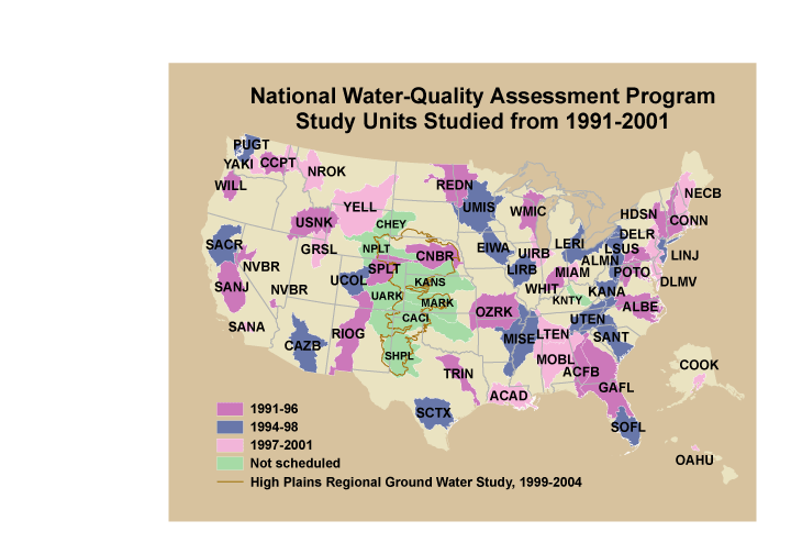
These data were released prior to the October 1, 2016 effective date for the USGS’s policy dictating the review, approval, and release of scientific data as referenced in USGS Survey Manual Chapter 502.8 Fundamental Science Practices: Review and Approval of Scientific Data for Release. This is a GENERALIZED version of the boundaries and codes used for the U.S. Geological Survey's National Water-Quality Assessment (NAWQA) Program Study-Unit investigations in the conterminous United States, excluding the High Plains Regional Ground-Water Study. The data set represents the areas studied during the first decade of the NAWQA Program, from 1991-2001 ("cycle 1"). The coverage is intended only for drawing ILLUSTRATIONS,...

These data were released prior to the October 1, 2016 effective date for the USGS’s policy dictating the review, approval, and release of scientific data as referenced in USGS Survey Manual Chapter 502.8 Fundamental Science Practices: Review and Approval of Scientific Data for Release. This product "Observed, predicted, and misclassification error data for observations in the training dataset for nitrate and arsenic concentrations in basin-fill aquifers in the Southwest Principal Aquifers study" is a 1:250,000-scale point dataset and was developed as part of a regional Southwest Principal Aquifers (SWPA) study. The study examined the vulnerability of basin-fill aquifers in the southwestern United States to nitrate...

These data were released prior to the October 1, 2016 effective date for the USGS’s policy dictating the review, approval, and release of scientific data as referenced in USGS Survey Manual Chapter 502.8 Fundamental Science Practices: Review and Approval of Scientific Data for Release. This spatial data set was created by the U.S. Geological Survey (USGS) to represent the amount of phosphorus generated by pastured, non-cattle livestock that was applied to pasture land in the Pacific Northwest region of the United States (Hydro Region 17; Major River Basin 7 (MRB7)) during 2002.

These data were released prior to the October 1, 2016 effective date for the USGS’s policy dictating the review, approval, and release of scientific data as referenced in USGS Survey Manual Chapter 502.8 Fundamental Science Practices: Review and Approval of Scientific Data for Release. This data set represents the presence or absence of semiconsolidated sand aquifers in the conterminous United States. The data set was used as an input data layer for a national model to predict nitrate concentration in ground water used for drinking. Nolan and Hitt (2006) developed two national models to predict contamination of ground water by nonpoint sources of nitrate. The nonlinear approach to national-scale Ground-WAter Vulnerability...

These data were released prior to the October 1, 2016 effective date for the USGS’s policy dictating the review, approval, and release of scientific data as referenced in USGS Survey Manual Chapter 502.8 Fundamental Science Practices: Review and Approval of Scientific Data for Release. This data set represents the average value of saturation overland flow, in percent of total streamflow, compiled for every catchment of NHDPlus for the conterminous United States. The source data set is Saturation Overland Flow Estimated by TOPMODEL for the Conterminous United States (Wolock, 2003). The NHDPlus Version 1.1 is an integrated suite of application-ready geospatial datasets that incorporates many of the best features...

These data were released prior to the October 1, 2016 effective date for the USGS’s policy dictating the review, approval, and release of scientific data as referenced in USGS Survey Manual Chapter 502.8 Fundamental Science Practices: Review and Approval of Scientific Data for Release. This data set represents the estimated amount of phosphorus and nitrogen fertilizers applied to selected crops for the year 2002, compiled for every catchment of NHDPlus for the conterminous United States. The source data set is based on 2002 fertilizer data (Ruddy and others, 2006) and tabulated by crop type per county (Alexander and others, 2007). The NHDPlus Version 1.1 is an integrated suite of application-ready geospatial datasets...

These data were released prior to the October 1, 2016 effective date for the USGS’s policy dictating the review, approval, and release of scientific data as referenced in USGS Survey Manual Chapter 502.8 Fundamental Science Practices: Review and Approval of Scientific Data for Release. This data set represents the average population density, in number of people per square kilometer multiplied by 10 for the year 2000, compiled for every catchment of NHDPlus for the conterminous United States. The source data set is the 2000 Population Density by Block Group for the Conterminous United States (Hitt, 2003). The NHDPlus Version 1.1 is an integrated suite of application-ready geospatial datasets that incorporates many...

These data were released prior to the October 1, 2016 effective date for the USGS’s policy dictating the review, approval, and release of scientific data as referenced in USGS Survey Manual Chapter 502.8 Fundamental Science Practices: Review and Approval of Scientific Data for Release. This tabular data set represents the 30-year (1971-2000) catchment-average total annual precipitation in millimeters multiplied by 100 compiled for every MRB_E2RF1 catchment of selected Major River Basins (MRBs, Crawford and others, 2006). The source data were the United States Average Monthly or Annual Minimum Precipitation, 1971 - 2000 raster data set produced by the PRISM Group at Oregon State University. The MRB_E2RF1 catchments...

These data were released prior to the October 1, 2016 effective date for the USGS’s policy dictating the review, approval, and release of scientific data as referenced in USGS Survey Manual Chapter 502.8 Fundamental Science Practices: Review and Approval of Scientific Data for Release. This tabular data set represents the average daily minimum temperature in Celsius multiplied by 100 for 2002, compiled for every MRB_E2RF1 catchment of selected Major River Basins (MRBs, Crawford and others, 2006). The source data were the Near-Real-Time High-Resolution Monthly Average Maximum/Minimum Temperature for the Conterminous United States for 2002 raster data set produced by the Spatial Climate Analysis Service at Oregon...

These data were released prior to the October 1, 2016 effective date for the USGS’s policy dictating the review, approval, and release of scientific data as referenced in USGS Survey Manual Chapter 502.8 Fundamental Science Practices: Review and Approval of Scientific Data for Release. This tabular data set represents the area of each physiographic province (Fenneman and Johnson, 1946) in square meters, compiled for every MRB_E2RF1 catchment of selected Major River Basins (MRBs, Crawford and others, 2006). The source data are from Fenneman and Johnson's Physiographic Provinces of the United States, which is based on 8 major divisions, 25 provinces, and 86 sections representing distinctive areas having common topography,...

These data were released prior to the October 1, 2016 effective date for the USGS’s policy dictating the review, approval, and release of scientific data as referenced in USGS Survey Manual Chapter 502.8 Fundamental Science Practices: Review and Approval of Scientific Data for Release. This tabular data set represents the mean base-flow index expressed as a percent, compiled for every catchment of MRB_E2RF1 catchments of Major River Basins (MRBs, Crawford and others, 2006). Base flow is the component of streamflow that can be attributed to ground-water discharge into streams. The source data set is Base-Flow Index for the Conterminous United States (Wolock, 2003). The MRB_E2RF1 catchments are based on a modified...
|

|
