Filters: Tags: nutrients (X)
278 results (10ms)|
Filters
Date Range
Extensions
Types Contacts
Categories
Tag Types
|
Southern Nevada Water Authority will add new modeling and analytical capabilities to tools developed as part of a previous WaterSMART Climate Analysis Tools Grant that assessed impacts of climate change on water quality and sediment transport in Lake Mead. Project results are intended to increase an understanding of how water quality characteristics and nutrient levels in Lake Mead may be affected by climate change.
Categories: Data,
Project;
Types: Downloadable,
Map Service,
OGC WFS Layer,
OGC WMS Layer,
Shapefile;
Tags: 2014,
AZ-04,
Applications and Tools,
Arizona,
Decision Support,
The Ohio-Kentucky-Indiana Water Science Center looks forward to helping you achieve your goals by providing water quantity and quality information, as well as scientific tools and understanding, when and where they are needed by citizens, businesses, and public officials.
This dataset contains taxonomy, density (cells/mL), and biovolume (μm3/mL) data for phytoplankton sampled across the Sacramento San Joaquin River Delta and San Francisco Bay (Bay-Delta) beginning in 2016. Whole water phytoplankton samples were collected intermittently during special projects and during routine visits to service continuous monitoring stations. Samples were preserved with Lugol’s iodine solution (2-5 %) immediately after collection and stored in a cool, dark environment until analysis. Preserved whole water samples are sent to BSA Environmental Services (BSA) in Beachwood, Ohio for microscopic identification and enumeration. A Leica DMLB compound microscope is used for enumerating filtered phytoplankton...
Problem The discharge of freshwater and associated loading of nutrients and other dissolved constituents from the Long Island aquifer system to surrounding estuaries and their tributaries are increasingly recognized as critical factors in the health of these ecosystems. However, further work is needed to scientifically characterize these factors and present them to the public in an appropriate manner. Many organizations have undertaken assessments of this discharge and loading for discrete groundwater source areas and (or) receiving surface waters, applying a variety of techniques and assumptions. In part, this is because there is no delineation of recharge areas to the island’s groundwater-fed streams and estuaries...
Nitrogen, phosphorus, and suspended-sediment loads, and changes in loads, in major rivers across the Chesapeake Bay watershed have been calculated using monitoring data from the Chesapeake Bay River Input Monitoring (RIM) Network stations for the period 1985 through 2022. Nutrient and suspended-sediment loads and changes in loads were determined by applying a weighted regression approach called WRTDS (Weighted Regression on Time, Discharge, and Season). The load results represent the total mass of nitrogen, phosphorus, and suspended sediment that was exported from each of the RIM watersheds.
Categories: Data;
Types: Map Service,
OGC WFS Layer,
OGC WMS Layer,
OGC WMS Service;
Tags: Chesapeake Bay Watershed,
Delaware,
Kalman filtering,
Maryland,
New York,
The U.S. Geological Survey maintains a program of water-quality studies in San Francisco Bay (CA) that began in 1969. This USGS data release archives and makes available all measurements from 1969-2015. Water-quality constituent measurements include salinity, temperature, light attenuation coefficient, and concentrations of chlorophyll-a, dissolved oxygen, suspended particulate matter, and dissolved inorganic nutrients (nitrate, nitrite, ammonium, phosphate and silicate). Since the mid-1990s, sampling was conducted at least monthly at 37 fixed sampling locations along a 145-km transect from lower South San Francisco Bay to the lower Sacramento River. A map and table of sampling locations are included in the Attached...
Categories: Data;
Types: Citation;
Tags: San Francisco Bay, California,
USGS Science Data Catalog (SDC),
chlorophyll-a,
dissolved oxygen,
nutrients,
These data were compiled as part of a long-term (1964 - 2022) water quality monitoring program at Lake Powell. Objectives of our study were to release a consistent record of long-term water quality data. The 58-year limnology dataset captures some water quality parameters (temperature, salinity, major ions, total suspended solids) from reservoir filling to present day. It also contains a 38-year record of secchi depth, and a ~30-year record of nutrients, phytoplankton, and zooplankton assemblages. The data were collected from various sites within the Lake Powell reservoir and the Glen Canyon dam. Regular monthly sampling occurred at three sites near the dam and reservoir-wide sampling was generally conducted quarterly,...
Categories: Data,
Data Release - Revised;
Tags: Arizona,
Aztec Creek,
Bridge Creek,
Cathedral Canyon,
Clear Creek,
Presented by Don Spalinger & Nathan WolfThis seminar focuses on our concepts of regulation of nutrient flows through tundra ecosystems and the effect that climate (or weather) has on these processes. Nutrient flow and climate, in turn, should regulate plant phenology and production, and thus caribou behavior and nutrition. We will present some ideas for assessing the landscape patterns of these processes and monitoring their impacts. Finally, we will provide examples of such assessment and monitoring processes from our work in Western Alaska over the past two years.
Categories: Data;
Tags: ALPINE/TUNDRA,
ALPINE/TUNDRA,
CARBON,
CARBON,
CARBON CYCLE/CARBON BUDGET MODELS,

These data were released prior to the October 1, 2016 effective date for the USGS’s policy dictating the review, approval, and release of scientific data as referenced in USGS Survey Manual Chapter 502.8 Fundamental Science Practices: Review and Approval of Scientific Data for Release. This data set represents the presence or absence of Valley and Ridge carbonate rocks in the conterminous United States. The data set was used as an input data layer for a national model to predict nitrate concentration in shallow ground water. Nolan and Hitt (2006) developed two national models to predict contamination of ground water by nonpoint sources of nitrate. The nonlinear approach to national-scale Ground-WAter Vulnerability...

These data were released prior to the October 1, 2016 effective date for the USGS’s policy dictating the review, approval, and release of scientific data as referenced in USGS Survey Manual Chapter 502.8 Fundamental Science Practices: Review and Approval of Scientific Data for Release. This data set represents predicted nitrate concentration in shallow, recently recharged ground water, in milligrams per liter, in the conterminous United States, and was generated by a national nonlinear regression model based on 16 input parameters. Nolan and Hitt (2006) developed two national models to predict contamination of ground water by nonpoint sources of nitrate. The nonlinear approach to national-scale Ground-WAter Vulnerability...

These data were released prior to the October 1, 2016 effective date for the USGS’s policy dictating the review, approval, and release of scientific data as referenced in USGS Survey Manual Chapter 502.8 Fundamental Science Practices: Review and Approval of Scientific Data for Release. This data set represents the area of National Resources Inventory irrigation system, tailwater recovery conservation practice, in square kilometers, in the conterminous United States. The data set was used as an input data layer for a national model to predict nitrate concentration in shallow ground water. Nolan and Hitt (2006) developed two national models to predict contamination of ground water by nonpoint sources of nitrate....

These data were released prior to the October 1, 2016 effective date for the USGS’s policy dictating the review, approval, and release of scientific data as referenced in USGS Survey Manual Chapter 502.8 Fundamental Science Practices: Review and Approval of Scientific Data for Release. This data set represents the amount of fresh surface water withdrawal for irrigation, in megaliters per day, in the conterminous United States. The data set was used as an input data layer for a national model to predict nitrate concentration in shallow ground water. Nolan and Hitt (2006) developed two national models to predict contamination of ground water by nonpoint sources of nitrate. The nonlinear approach to national-scale...
The dataset documents the spatial and temporal variability of nutrients, phytoplankton, and related water quality parameters at high spatial resolution in the Sacramento-San Joaquin River Delta and Suisun Bay of California, USA. The dataset includes nitrate, ammonium, orthophosphate, dissolved organic carbon, temperature, conductivity, dissolved oxygen, and chlorophyll as well as information about phytoplankton community composition. Data were collected under different environmental/flow conditions in June, July, August, and October of 2020, and May, July, and October of 2021. The data release consists of a .xml document, and .txt and shapefile documents. Descriptions for each document and file are listed in the...
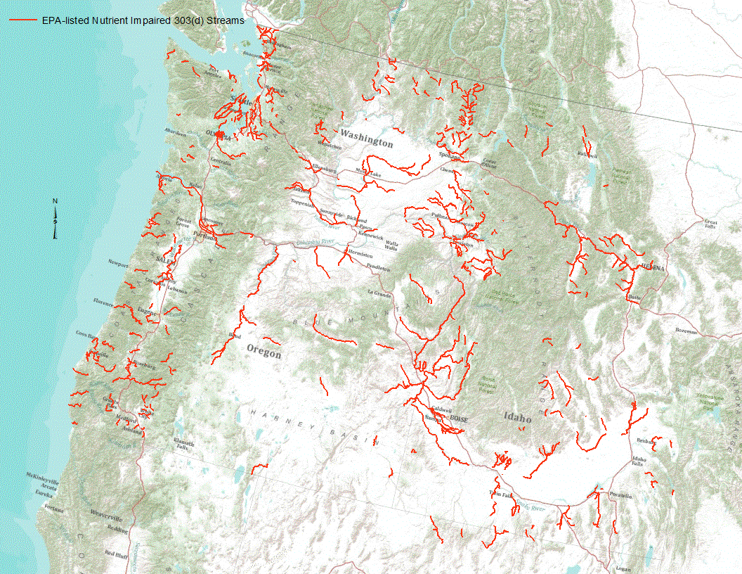
“Under section 303(d) of the 1972 Clean Water Act, states, territories, and authorized tribes are required to develop lists of impaired waters. These impaired waters do not meet water quality standards that states, territories, and authorized tribes have set for them, even after point sources of pollution have installed the minimum required levels of pollution control technology. The law requires that these jurisdictions establish priority rankings for waters on the lists and develop TMDLs for these waters” (U.S. Environmental Protection Agency, 2011). Waterways represented in this data set are a subset of these EPA 303 (d) listed streams that were classified as nutrient impaired. Nutrient impaired streams include...
Description of Work Participation on the Lake Erie Lakewide Management Plan Workgroup and related subcommittees such as toxics, sources and loads, nutrients, and biodiversity. Attend meetings and conferences associated with LE LAMP activities. This includes The Lake Erie Millennium Network, CSMI, Ohio Phosphorus Task Force, and other meetings or workshops addressing nutrient and toxicity issues in Lake Erie. Communicate USGS activities in the Lake Erie Basin that can influence understanding or impact decision making.
Categories: Project;
Types: Map Service,
OGC WFS Layer,
OGC WMS Layer,
OGC WMS Service;
Tags: Accountability,
Areas of concern,
Assessment,
Beneficial use impairment,
Binational,
Improve understanding of physical and biogeochemical processes affecting water quality of groundwater and surface water. Research focus includes multidisciplinary field and laboratory studies to determine factors affecting sources, movement, and fate of nutrients and reactive inorganic contaminants in the hydrologic cycle. Improve the usefulness of stable isotopes and other environmental tracers in hydrology and biogeochemistry by developing new techniques and approaches. Research topics include analytical techniques for stable isotopes in compounds separated from groundwater and surface water, stable isotope forensics, enriched isotope tracer experiments to quantify transport and reaction rates, field and...
Categories: Project;
Tags: Biogeochemistry,
Contaminants,
Groundwater Flow and Transport,
Isotopic Tracers,
Nutrients,

Estimated nitrogen delivered to the estuaries along the Gulf of Mexico (U.S. only). Delivered yield is an estimate of the amount of nitrogen delivered to an estuary divided by the area of the upstream drainage area that drains into the estuary. Units are kg/km2/year.
Nitrogen, phosphorus, and suspended-sediment loads, and changes in loads, in major rivers across the Chesapeake Bay watershed have been calculated using monitoring data from the Chesapeake Bay River Input Monitoring (RIM) stations for the period 1985 through 2019. Nutrient and suspended-sediment loads and changes in loads were determined by applying a weighted regression approach called WRTDS (Weighted Regression on Time, Discharge, and Season). The load results represent the total mass of nitrogen, phosphorus, and suspended sediment that was exported from each of the RIM watersheds. To determine the trend in loads, the annual load results are flow normalized to integrate out the year-to-year variability in river...
Types: Map Service,
OGC WFS Layer,
OGC WMS Layer,
OGC WMS Service;
Tags: Chesapeake Bay Watershed,
Delaware,
Maryland,
New York,
Pennsylvania,
This data release consists of the data used to develop SPAtially Referenced Regression On Watershed(SPARROW) attributes models for estimating loads of total phosphorus and total nitrogen in Tennessee streams. These data support the publication containing the Tennessee SPARROW models results (Hoos and others, 2019) and include model input used in the South Atlantic-Gulf Drainages and Tennessee River Basin (SAGT) nutrient SPARROW models (Hoos and McMahon, 2009; Garcia and others, 2011) as well as model input for river basins in Tennessee not included in the domain of the published SAGT SPARROW models. Also included in this data release are model coefficients, the software required to execute the Tennessee SPARROW...
Nitrogen, phosphorus, and suspended-sediment loads, and changes in loads, in rivers across the Chesapeake Bay watershed have been calculated using monitoring data from the Chesapeake Bay Nontidal Network (NTN) stations for the period 1985 through 2018. Nutrient and suspended-sediment loads and changes in loads were determined by applying a weighted regression approach called WRTDS (Weighted Regression on Time, Discharge, and Season). The load results represent the total mass of nitrogen, phosphorus, and suspended sediment that was exported from each of the NTN watersheds. To determine the trend in loads, the annual load results are flow normalized to integrate out the year-to-year variability in river discharge....
Categories: Data;
Types: Map Service,
OGC WFS Layer,
OGC WMS Layer,
OGC WMS Service;
Tags: Chesapeake Bay Watershed,
Delaware,
Maryland,
New York,
Pennsylvania,
|

|
