Filters: Tags: parcel (X)
10 results (12ms)|
Filters
Date Range
Types Contacts
Tag Types Tag Schemes |
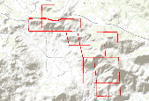
Skyline Land Partners parcels. These were extracted from this larger dataset:Parcels for the entire county Source: COGO: COGO is a computer program that is used to calculate coordinate geometry. It is used to solve the geometric problems encountered in civil engineering applications including: property boundary and right of way surveys highway and interchange design construction layout bridge geometry.
The USGS Forecasting Scenarios of Land-use Change (FORE-SCE) model was used to produce an agricultural biofuel scenarios for the Northern Glaciated Plains, from 2012 to 2030. The modeling used parcel data from the USDA's Common Land Unit (CLU) data set to represent real, contiguous ownership and land management units. A Monte Carlo approach was used to create 50 unique replicates of potential landscape conditions in the future, based on a agricultural scenario from the U.S. Department of Energy's Billion Ton Update. The data are spatially explicit, covering the entire Northern Glaciated Plains ecoregions (an EPA Level III ecoregion), with a spatial resolution of 30-meters and 22 unique land-cover classes (including...
Types: Citation,
Map Service,
OGC WFS Layer,
OGC WMS Layer,
OGC WMS Service;
Tags: FORE-SCE,
Great Plains,
Land Cover,
Minnesota,
Model,

Parcels for the entire county Source: COGO: COGO is a computer program that is used to calculate coordinate geometry. It is used to solve the geometric problems encountered in civil engineering applications including: property boundary and right of way surveys highway and interchange design construction layout bridge geometry.

Parcels in the south-western portion of the County of San Diego.
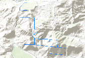
·Boundary of the South Crest Properties with parcel boundaries. Parcels in the County of San Diego.

Parcels for the entire county Source: COGO: COGO is a computer program that is used to calculate coordinate geometry. It is used to solve the geometric problems encountered in civil engineering applications including: property boundary and right of way surveys highway and interchange design construction layout bridge geometry.

The original dataset was modified by Conservation Biology Institute in the following ways: Only parcels that intersected desired Land Use categories were selected for inclusion; all unnecessary attributes for natural resources planning purposes were deleted. Parcels for the entire county Source: COGO: COGO is a computer program that is used to calculate coordinate geometry. It is used to solve the geometric problems encountered in civil engineering applications including: property boundary and right of way surveys highway and interchange design construction layout bridge geometry.
|

|


