Filters: Tags: power (X)
413 results (253ms)|
Filters
Date Range
Extensions Types Contacts
Categories Tag Types
|
This data set contains imagery from the National Agriculture Imagery Program (NAIP). The NAIP program is administered by USDA FSA and has been established to support two main FSA strategic goals centered on agricultural production. These are, increase stewardship of America's natural resources while enhancing the environment, and to ensure commodities are procured and distributed effectively and efficiently to increase food security. The NAIP program supports these goals by acquiring and providing ortho imagery that has been collected during the agricultural growing season in the U.S. The NAIP ortho imagery is tailored to meet FSA requirements and is a fundamental tool used to support FSA farm and conservation programs....
This data set contains imagery from the National Agriculture Imagery Program (NAIP). The NAIP program is administered by USDA FSA and has been established to support two main FSA strategic goals centered on agricultural production. These are, increase stewardship of America's natural resources while enhancing the environment, and to ensure commodities are procured and distributed effectively and efficiently to increase food security. The NAIP program supports these goals by acquiring and providing ortho imagery that has been collected during the agricultural growing season in the U.S. The NAIP ortho imagery is tailored to meet FSA requirements and is a fundamental tool used to support FSA farm and conservation programs....
This data set contains imagery from the National Agriculture Imagery Program (NAIP). The NAIP program is administered by USDA FSA and has been established to support two main FSA strategic goals centered on agricultural production. These are, increase stewardship of America's natural resources while enhancing the environment, and to ensure commodities are procured and distributed effectively and efficiently to increase food security. The NAIP program supports these goals by acquiring and providing ortho imagery that has been collected during the agricultural growing season in the U.S. The NAIP ortho imagery is tailored to meet FSA requirements and is a fundamental tool used to support FSA farm and conservation programs....
This data set contains imagery from the National Agriculture Imagery Program (NAIP). The NAIP program is administered by USDA FSA and has been established to support two main FSA strategic goals centered on agricultural production. These are, increase stewardship of America's natural resources while enhancing the environment, and to ensure commodities are procured and distributed effectively and efficiently to increase food security. The NAIP program supports these goals by acquiring and providing ortho imagery that has been collected during the agricultural growing season in the U.S. The NAIP ortho imagery is tailored to meet FSA requirements and is a fundamental tool used to support FSA farm and conservation programs....
This data set contains imagery from the National Agriculture Imagery Program (NAIP). The NAIP program is administered by USDA FSA and has been established to support two main FSA strategic goals centered on agricultural production. These are, increase stewardship of America's natural resources while enhancing the environment, and to ensure commodities are procured and distributed effectively and efficiently to increase food security. The NAIP program supports these goals by acquiring and providing ortho imagery that has been collected during the agricultural growing season in the U.S. The NAIP ortho imagery is tailored to meet FSA requirements and is a fundamental tool used to support FSA farm and conservation programs....
This data set contains imagery from the National Agriculture Imagery Program (NAIP). The NAIP program is administered by USDA FSA and has been established to support two main FSA strategic goals centered on agricultural production. These are, increase stewardship of America's natural resources while enhancing the environment, and to ensure commodities are procured and distributed effectively and efficiently to increase food security. The NAIP program supports these goals by acquiring and providing ortho imagery that has been collected during the agricultural growing season in the U.S. The NAIP ortho imagery is tailored to meet FSA requirements and is a fundamental tool used to support FSA farm and conservation programs....
This data set contains imagery from the National Agriculture Imagery Program (NAIP). The NAIP program is administered by USDA FSA and has been established to support two main FSA strategic goals centered on agricultural production. These are, increase stewardship of America's natural resources while enhancing the environment, and to ensure commodities are procured and distributed effectively and efficiently to increase food security. The NAIP program supports these goals by acquiring and providing ortho imagery that has been collected during the agricultural growing season in the U.S. The NAIP ortho imagery is tailored to meet FSA requirements and is a fundamental tool used to support FSA farm and conservation programs....
This data set contains imagery from the National Agriculture Imagery Program (NAIP). The NAIP program is administered by USDA FSA and has been established to support two main FSA strategic goals centered on agricultural production. These are, increase stewardship of America's natural resources while enhancing the environment, and to ensure commodities are procured and distributed effectively and efficiently to increase food security. The NAIP program supports these goals by acquiring and providing ortho imagery that has been collected during the agricultural growing season in the U.S. The NAIP ortho imagery is tailored to meet FSA requirements and is a fundamental tool used to support FSA farm and conservation programs....
This data set contains imagery from the National Agriculture Imagery Program (NAIP). The NAIP program is administered by USDA FSA and has been established to support two main FSA strategic goals centered on agricultural production. These are, increase stewardship of America's natural resources while enhancing the environment, and to ensure commodities are procured and distributed effectively and efficiently to increase food security. The NAIP program supports these goals by acquiring and providing ortho imagery that has been collected during the agricultural growing season in the U.S. The NAIP ortho imagery is tailored to meet FSA requirements and is a fundamental tool used to support FSA farm and conservation programs....
This data set contains imagery from the National Agriculture Imagery Program (NAIP). The NAIP program is administered by USDA FSA and has been established to support two main FSA strategic goals centered on agricultural production. These are, increase stewardship of America's natural resources while enhancing the environment, and to ensure commodities are procured and distributed effectively and efficiently to increase food security. The NAIP program supports these goals by acquiring and providing ortho imagery that has been collected during the agricultural growing season in the U.S. The NAIP ortho imagery is tailored to meet FSA requirements and is a fundamental tool used to support FSA farm and conservation programs....

This dataset was derived from the U.S. Environmental Protection Agency's Emissions & Generation Resource Integrated Database (eGRID2012 Version 1.0). http://www.epa.gov/cleanenergy/energy-resources/egrid/index.html These data were downloaded in MS EXCEL format and converted to a feature class in a geodatabase. eGRID2012 Version 1.0 is the eighth edition of eGRID, which contains the complete release of year 2009 data, as well as year 2007 data contained in eGRID2010 Version 1.1 that was released in May 2011, year 2005 data contained in eGRID2007 Version 1.1 that was released in January 2009, and year 2004 data contained in eGRID2006 Version 2.1 that was released in Spring 2007. The Emissions & Generation Resource...
To address climate change and other are sustainability imperatives, the private sector has launched various initiatives that are aimed to evaluate and reduce the impact throughout the life cycle of consumer products. Recently, multi-national retailers and manufacturers have initiated a unified approach in creating sustainable indexing programs for the products they make and sell. Often overlooked in addressing pressing sustainability imperatives such as climate change are the consumptive patterns and impact of consumer goods during the consumer use phase. This article presents an empirical study of the consumer use phase of laundry care with a specific focus on electricity consumption and carbon dioxide emissions....
To address climate change and other are sustainability imperatives, the private sector has launched various initiatives that are aimed to evaluate and reduce the impact throughout the life cycle of consumer products. Recently, multi-national retailers and manufacturers have initiated a unified approach in creating sustainable indexing programs for the products they make and sell. Often overlooked in addressing pressing sustainability imperatives such as climate change are the consumptive patterns and impact of consumer goods during the consumer use phase. This article presents an empirical study of the consumer use phase of laundry care with a specific focus on electricity consumption and carbon dioxide emissions....
A visual impact evaluation method specifically designed to assess landscape alteration as a result of surface mining and quarrying would represent a fundamental aid for both those involved in the early stages of mine planning and design (mining companies) and those in charge of controlling and verifying environmental impacts (government authorities). This research is based on implementation of the visual impact indicator Lvi, which takes into account two parameters among those physically measurable: the extent of visible alteration in the landscape and the chromatic contrast between bare rock and the surrounding environment. Both parameters can be quantified by processing one or more digital images taken from the...
Categories: Publication;
Types: Citation;
Tags: Power,
attitudes,
comparative,
initiative,
moratorium,
Federal policymakers must not neglect to rationalize the allocation of jurisdiction between federal and state regulators, remove impediments to the expansion of the interstate transmission grid, and support the development of demand-side responsiveness to market pricing.
Categories: Publication;
Types: Citation;
Tags: Well-functioning,
balanced,
integration,
markets,
power,

Annual average wind resource potential of Vermont at a 50 meter height. Available from the National Renewable Energy Laboratory (NREL) at http://www.nrel.gov/renewable_resources/. This dataset was last updated on 2/20/09.

Annual average wind resource potential for the state of Hawaii at a 50 meter height. Available from the National Renewable Energy Laboratory (NREL) at http://www.nrel.gov/renewable_resources/ . This dataset was last updated on 6/04/2009.
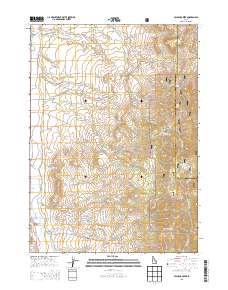
Layered GeoPDF 7.5 Minute Quadrangle Map. Layers of geospatial data include orthoimagery, roads, grids, geographic names, elevation contours, hydrography, and other selected map features.
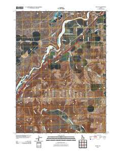
Layered GeoPDF 7.5 Minute Quadrangle Map. Layers of geospatial data include orthoimagery, roads, grids, geographic names, elevation contours, hydrography, and other selected map features.
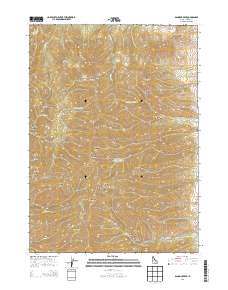
Layered GeoPDF 7.5 Minute Quadrangle Map. Layers of geospatial data include orthoimagery, roads, grids, geographic names, elevation contours, hydrography, and other selected map features.
|

|
