Filters: Tags: protected areas (X)
312 results (5ms)|
Filters
|

Protected areas are cornerstones of national and international conservation strategies. By way of these designations, lands and waters are set-aside in-perpetuity to preserve functioning natural ecosystems, act as refuges for species, and maintain ecological processes. Complementary conservation strategies preserve land for the sustainable use of natural resources, or for the protection of significant geologic and cultural features or open space. PAD-US 1.1 (CBI Edition) attempts to include all available spatial data on these places. It is our goal to publish the most comprehensive geospatial data set of U. S. protected areas to date. PAD-US 1.1 (CBI Edition) is limited to the continental U.S., Alaska, and Hawaii....

Protected areas are cornerstones of national and international conservation strategies. By way of these designations, lands and waters are set-aside in-perpetuity to preserve functioning natural ecosystems, act as refuges for species, and maintain ecological processes. Complementary conservation strategies preserve land for the sustainable use of natural resources, or for the protection of significant geologic and cultural features or open space. PAD-US 1.1 (CBI Edition) attempts to include all available spatial data on these places. It is our goal to publish the most comprehensive geospatial data set of U. S. protected areas to date. PAD-US 1.1 (CBI Edition) is limited to the continental U.S., Alaska, and Hawaii....
This dataset is an extraction from PAD-US 1.1 (CBI Edition), by National Parks management designation. The PAD-US 1.1 (CBI Edition) data set portrays the nation's protected areas with a standardized spatial geometry and numerous valuable attributes on land ownership, management designations, and conservation status (using national GAP and international IUCN coding systems). The PAD-US 1.1 (CBI Edition) defines protected areas to include all lands dedicated to the preservation of biological diversity and to other natural, recreation and cultural uses, and managed for these purposes through legal or other effective means (adapted from IUCN definition). The database represents the full range of conservation designations...
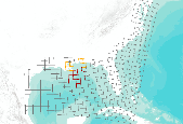
A 75,000 x 75,000 meter grid covering the Gulf of Mexico, created to identify possible areas of landfall of oil from the Deepwater Horizon oil spill. Using oil spill trajectories produced by the Ocean Circulation Group and the Optical Oceanography Laboratory at the College of Marine Science, University of South Florida, and protected areas data catalogued in PAD-US (CBI Edition) , we provide a preliminary attempt to identify ecological resources that may be affected by the spill. By overlaying these projected trajectories on a standardized grid, we can select areas that may contain oil from the spill, or are likely to contain oil in the future. We then identify protected areas that are likely to be most directly...
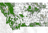
(A newer version of these data is now available, Protected Areas - Montana, October 2012 ) This dataset is an extraction from PAD-US 1.1 (CBI Edition), by state. The PAD-US 1.1 (CBI Edition) data set portrays the nation's protected areas with a standardized spatial geometry and numerous valuable attributes on land ownership, management designations, and conservation status (using national GAP and international IUCN coding systems). The PAD-US 1.1 (CBI Edition) defines protected areas to include all lands dedicated to the preservation of biological diversity and to other natural, recreation and cultural uses, and managed for these purposes through legal or other effective means (adapted from IUCN definition). The...
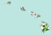
(A newer version of these data is now available, Protected Areas - Hawaii, October 2012 ) This dataset is an extraction from PAD-US 1.1 (CBI Edition), by state. The PAD-US 1.1 (CBI Edition) data set portrays the nation's protected areas with a standardized spatial geometry and numerous valuable attributes on land ownership, management designations, and conservation status (using national GAP and international IUCN coding systems). The PAD-US 1.1 (CBI Edition) defines protected areas to include all lands dedicated to the preservation of biological diversity and to other natural, recreation and cultural uses, and managed for these purposes through legal or other effective means (adapted from IUCN definition). The...

These data are an extraction of state, local and private conservation lands from PAD-US (CBI Edition) Version 2. PAD-US (CBI Edition) Version 2 is a national database of protected fee lands in the United States. PAD-US (CBI Edition) Version 2 has been redesigned to be used along with the National Conservation Easement Database (NCED), to visualize the entire terrestrial conservation estate of the United States. PAD-US (CBI Edition) Version 2 is limited to the continental U.S., Alaska, and Hawaii. It does not include protected areas data for U.S. territories at this time. Protected areas are cornerstones of national and international conservation strategies. By way of these designations, lands and waters are set...

This dataset is extracted from PAD-US 1.1 (CBI Edition), and the original metadata has been included here, below. These protected areas were roughly identified by the Conservation Biology Institute as being secondarily threatened by the Deepwater Horizon oil spill in the Gulf of Mexico. The probability of being affected was determined using the University of South Florida's Deepwater Horizon oil spill trajectory forecast from the WFS ROMS numerical model, as projected for 06/11/2010 at 00h UTC (http://ocg6.marine.usf.edu/~liu/oil_spill_ensemble_forecast.html). For more information, please see the Oil Spill in the Gulf of Mexico page at Data Basin (http://www.databasin.org/aquatic-center/features/oil-spill or http://www.databasin.org)....

(A newer version of these data is now available, Protected Areas - Minnesota, October 2012 ) This dataset is an extraction from PAD-US 1.1 (CBI Edition), by state. The PAD-US 1.1 (CBI Edition) data set portrays the nation's protected areas with a standardized spatial geometry and numerous valuable attributes on land ownership, management designations, and conservation status (using national GAP and international IUCN coding systems). The PAD-US 1.1 (CBI Edition) defines protected areas to include all lands dedicated to the preservation of biological diversity and to other natural, recreation and cultural uses, and managed for these purposes through legal or other effective means (adapted from IUCN definition)....

(A newer version of these data is now available, Protected Areas - Maine, October 2012 ) This dataset is an extraction from PAD-US 1.1 (CBI Edition), by state. The PAD-US 1.1 (CBI Edition) data set portrays the nation's protected areas with a standardized spatial geometry and numerous valuable attributes on land ownership, management designations, and conservation status (using national GAP and international IUCN coding systems). The PAD-US 1.1 (CBI Edition) defines protected areas to include all lands dedicated to the preservation of biological diversity and to other natural, recreation and cultural uses, and managed for these purposes through legal or other effective means (adapted from IUCN definition). The...

This polygon data set includes the protected areas of the Northern Mountain States of the United States of America that are managed by national, state, provincial, or territorial authorities. As defined by the International Union for the Conservation of Nature (IUCN), a protected area is an area of land and/or sea especially dedicated to the protection and maintenance of biological diversity, and of natural and associated cultural resources, and managed through legal or other effective means. The data set was assembled for the Commission for Environmental Cooperation (CEC) from other public data sets containing data on protected areas in Canada, Mexico, and the United States. Protected area data was obtained from...

These data area an extraction from PAD-US (CBI Edition) Version 2 of National Wildlife Refuge. PAD-US (CBI Edition) Version 2 is a national database of protected fee lands in the United States. PAD-US (CBI Edition) Version 2 has been redesigned to be used along with the National Conservation Easement Database (NCED), to visualize the entire terrestrial conservation estate of the United States. PAD-US (CBI Edition) Version 2 is limited to the continental U.S., Alaska, and Hawaii. It does not include protected areas data for U.S. territories at this time. Protected areas are cornerstones of national and international conservation strategies. By way of these designations, lands and waters are set aside in-perpetuity...

This dataset is an extract of the full PAD-US (CBI Edition) Version 2 for New Jersey. For more information about this dataset, and to download the full US dataset, please go to: http://consbio.org/products/projects/pad-us-cbi-edition PAD-US (CBI Edition) Version 2 is a national database of protected fee lands in the United States. PAD-US (CBI Edition) Version 2 has been redesigned to be used along with the National Conservation Easement Database (NCED) , to visualize the entire terrestrial conservation estate of the United States. PAD-US (CBI Edition) Version 2 is limited to the continental U.S., Alaska, and Hawaii. It does not include protected areas data for U.S. territories at this time. Protected areas are...

This dataset is an extract of the full PAD-US (CBI Edition) Version 2 for Massachusetts. For more information about this dataset, and to download the full US dataset, please go to: http://consbio.org/products/projects/pad-us-cbi-edition PAD-US (CBI Edition) Version 2 is a national database of protected fee lands in the United States. PAD-US (CBI Edition) Version 2 has been redesigned to be used along with the National Conservation Easement Database (NCED) , to visualize the entire terrestrial conservation estate of the United States. PAD-US (CBI Edition) Version 2 is limited to the continental U.S., Alaska, and Hawaii. It does not include protected areas data for U.S. territories at this time. Protected areas...

This dataset is an extract of the full PAD-US (CBI Edition) Version 2 for Kansas. For more information about this dataset, and to download the full US dataset, please go to: http://consbio.org/products/projects/pad-us-cbi-edition PAD-US (CBI Edition) Version 2 is a national database of protected fee lands in the United States. PAD-US (CBI Edition) Version 2 has been redesigned to be used along with the National Conservation Easement Database (NCED) , to visualize the entire terrestrial conservation estate of the United States. PAD-US (CBI Edition) Version 2 is limited to the continental U.S., Alaska, and Hawaii. It does not include protected areas data for U.S. territories at this time. Protected areas are cornerstones...

This dataset is an extract of the full PAD-US (CBI Edition) Version 2 for Colorado. For more information about this dataset, and to download the full US dataset, please go to: http://consbio.org/products/projects/pad-us-cbi-edition PAD-US (CBI Edition) Version 2 is a national database of protected fee lands in the United States. PAD-US (CBI Edition) Version 2 has been redesigned to be used along with the National Conservation Easement Database (NCED) , to visualize the entire terrestrial conservation estate of the United States. PAD-US (CBI Edition) Version 2 is limited to the continental U.S., Alaska, and Hawaii. It does not include protected areas data for U.S. territories at this time. Protected areas are cornerstones...

This dataset is an extract of the full PAD-US (CBI Edition) Version 2 for Arizona. For more information about this dataset, and to download the full US dataset, please go to: http://consbio.org/products/projects/pad-us-cbi-edition PAD-US (CBI Edition) Version 2 is a national database of protected fee lands in the United States. PAD-US (CBI Edition) Version 2 has been redesigned to be used along with the National Conservation Easement Database (NCED) , to visualize the entire terrestrial conservation estate of the United States. PAD-US (CBI Edition) Version 2 is limited to the continental U.S., Alaska, and Hawaii. It does not include protected areas data for U.S. territories at this time. Protected areas are cornerstones...

This dataset is an extraction from PAD-US 1.1 (CBI Edition), by state. The PAD-US 1.1 (CBI Edition) data set portrays the nation's protected areas with a standardized spatial geometry and numerous valuable attributes on land ownership, management designations, and conservation status (using national GAP and international IUCN coding systems). The PAD-US 1.1 (CBI Edition) defines protected areas to include all lands dedicated to the preservation of biological diversity and to other natural, recreation and cultural uses, and managed for these purposes through legal or other effective means (adapted from IUCN definition). The database represents the full range of conservation designations that preserve these...

The Protected Areas Database-Aviation (PAD-Aviation) is a subset of the more comprehensive PAD-US v1.1 (CBI Edition). In cooperation with the US Air Force, other military branches, defense contractors, and protected areas specialist PAD-Aviation was tailored to include designations identified as sensitive or potentially sensitive to aircraft over-flight. Avoidance of airspace over various sensitive areas (including many designated protected areas) is mandated by public law, including Federal Aviation Administration (FAA) regulations and Department of Defense (DoD) Service Branch regulations. Until now, aviators used a variety of sources to help them identify these areas. Sectional charts, Flight Information Publications...

The Protected Areas Database-Aviation (PAD-Aviation) is a subset of the more comprehensive PAD-US v1.1 (CBI Edition). In cooperation with the US Air Force, other military branches, defense contractors, and protected areas specialist PAD-Aviation was tailored to include designations identified as sensitive or potentially sensitive to aircraft over-flight. Avoidance of airspace over various sensitive areas (including many designated protected areas) is mandated by public law, including Federal Aviation Administration (FAA) regulations and Department of Defense (DoD) Service Branch regulations. Until now, aviators used a variety of sources to help them identify these areas. Sectional charts, Flight Information Publications...
|

|
