Filters: Tags: river (X)
454 results (54ms)|
Filters
Date Range
Extensions Types
Contacts
Categories
Tag Types
|
This data release provides an example data set to accompany the manuscript titled "A Robot Operating System (ROS) package for mapping flow fields in rivers via Particle Image Velocimetry (PIV)", submitted to the journal Software X. This ROS *.bag file contains remotely sensed data acquired during an Uncrewed Aircraft System (UAS) flight along a reach of the Sacramento River near Glenn, California, USA, on September 16, 2022. Cooperators on this project include the Intelligent Robotics Group from the National Aeronautics and Space Administration (NASA) Ames Research Center and the National Oceanographic and Atmospheric Administration (NOAA) Southwest Fisheries Science Center. The file bag6xs600.bag contains a single...
This dataset represents a variety of scientific measurements of basalt rock outcrops in central Oregon, United States. It consists of field observations, geochemical measurements, paleomagnetic directional measurements, magnetic susceptibility, and geochronology data (Ar-Ar methodology). This dataset was collected from 2014-2022 by the authors.
This data release includes the data and code used for the paper titled "A framework to facilitate development and testing of image-based river velocimetry algorithms", published in the journal Earth Surface Processes and Landforms. Three *.csv files and five *.m files with MATLAB source code are included below. Each *.csv file contains output from a hydrodynamic model of a reach of the Sacramento River near Glenn, California, with a separate file for each of three different discharges (i.e., streamflow rates): 90, 191, and 255 cubic meters per second. The hydrodynamic model used for this purpose was the Nays2DH solver available within the International River Cooperative Interface (iRIC). Provided below is a link...
Categories: Data;
Types: Map Service,
OGC WFS Layer,
OGC WMS Layer,
OGC WMS Service;
Tags: California,
Geomorphology,
Glenn,
Hydrodynamic model,
Hydrology,
This dataset includes monthly dissolved silicon (DSi) concentration data from 198 rivers across the Northern Hemisphere. Concentration and discharge data were sourced from public and/or published datasets and the Weighted Regressions on Time, Discharge, and Season model (Hirsch et al. 2010) was used to estimate monthly concentrations and flow-normalized concentrations for all sites over their period of record. Sites span eight climate zones, ranged from 18 degrees N to 70 degrees N, and vary in drainage area from < 1 km2 to nearly 3 million km2. These monthly concentration data were then used to cluster sites into average (i.e., average of all years) and annual (i.e., each year individually) seasonal regimes using...
Continuous water temperature data were collected at multiple sites along the Middle Fork and mainstem Willamette Rivers between Jasper and Newberg, Oregon, to support effectiveness monitoring for a large-scale channel and floodplain restoration program (Willamette Focused Investment Partnership, WFIP). Continuous water temperature loggers were deployed at a subset of WFIP restoration sites where river restoration activities were implemented to improve habitat conditions for native fish species. Data from water temperature monitoring will be used to evaluate the effectiveness of restoration activities at improving habitat conditions for Endangered Species Act (ESA)-listed salmonids and other native fish in the Willamette...
Categories: Data;
Tags: Albany,
Bowers Rock State Park,
Browns Island,
Collins Bay,
Middle Fork Willamette River,
This data set includes nitrate concentration, water temperature, and discharge collected every 15 minutes during Dec. 2011 - Nov. 2013 from the USGS gage at the Potomac River near Wash, DC, Little Falls Pump Sta (01646500). Additional data includes day length from the US Naval Observatory, and photosynthetically active radiation from USDA research station in Beltsville, MD. Data on channel width and velocity based on manual discharge measurements made at the USGS gage at the Potomac River at Point of Rocks, MD (01638500) are included and were applied to calculate diel nitrate loss rates. Several calculations derived from these data are included in the data set. These data support the following publication: Burns,...
Categories: Data;
Types: Citation;
Tags: Chesapeake Bay,
Potomac River,
USGS Science Data Catalog (SDC),
Water Quality,
diel variation,
This dataset has been archived; it has been superseded by version 1.1 (December 2022) which can be found at https://doi.org/10.5066/P9SLP8FX. This U.S. Geological Survey data release provides surface-water quality, streamflow, and groundwater-elevation data collected within the Central Pine Barrens (CPB) Region of Suffolk County, New York, from October 1, 2019 through September 30, 2020. The data were collected in cooperation with the Central Pine Barrens Commission and the Town of Brookhaven as part of a five-year comprehensive water-resources monitoring program. Water quality and quality-assurance data from seven sites on two rivers (Carmans River- five sites and Peconic River- two sites) in the CPB are included....
Categories: Data;
Tags: Ambient Monitoring,
Contaminants, Emerging,
Contaminants, Natural,
Contaminants, Organic,
Environmental Health,
This U.S. Geological Survey (USGS) Data Release provides phytoplankton data collected from the Kansas River and tributaries, during July 2012 through February 2017. All data are reported as raw calculated values and are not rounded to USGS significant figures. This data release was produced in compliance with the open data requirements as a way to make scientific products associated with USGS research efforts and publications available to the public. The dataset includes all routine and quality assurance/quality control samples collected at two locations along the Kansas River (USGS station numbers 06887500, 06892350) and three tributary sites (USGS station numbers 06857100, 06887000, 06890900). Phytoplankton were...
Categories: Data;
Types: Citation;
Tags: 2-Methylisoborneol,
Algae,
Big Blue River nr Manhattan, KS,
Cylindrospermopsin,
Delaware River at Perry, KS,
This U.S. Geological Survey (USGS) data release provides phytoplankton data collected from the Kansas River and tributaries, during September through November 2011. All data are reported as raw calculated values and are not rounded to USGS significant figures. This data release was produced in compliance with open data requirements as a way to make scientific products associated with USGS research efforts and publications available to the public. The dataset includes all routine and quality assurance samples collected from 16 sites.
Categories: Data;
Tags: Algae,
Big Blue River nr Manhattan, KS,
Delaware River at Perry, KS,
Division,
Freshwater,
This data release includes the input topographic data sets, model parameters, and validation field measurements of flow velocity used to develop and test multidimensional hydraulic models for a reach of the upper Sacramento River in northern California. Digital elevation models (DEMs) were developed by combining water depth maps of the reach, created using spectrally-based remote sensing methods, with light detection and ranging (lidar) data on water surface and terrestrial elevations. The depth maps were derived from three imagery sources: (1) airborne hyperspectral imagery (CASI); (2) uncrewed aerial survey (UAS)-based hyperspectral imagery (Nano); and (3) multispectral satellite imagery (WV3). The methods used...
Categories: Data;
Types: Map Service,
OGC WFS Layer,
OGC WMS Layer,
OGC WMS Service;
Tags: Aquatic Biology,
California,
Cottonwood Creek,
Digital elevation model,
Geomorphology,
Bathymetric data were collected from select sites along the Kootenai River in northern Idaho, September 26-27, 2017, to support research on sturgeon habitat, dispersion processes, and geomorphic change along the Kootenai and, more broadly, remote sensing of rivers. The U.S. Geological Survey (USGS) National Geospatial Program (NGP) and National Research Program (NRP) acquired hyperspectral image data from the Kootenai River near Bonners Ferry, ID. The image data extended from the Kootenai Tribal FishHatchery downstream to the Copeland bridge. Image data acquisition occurred on September 27, 2017. A field team collected ground truthing data within the project area to calibrate and validate estimates of water depth...
Types: Map Service,
OGC WFS Layer,
OGC WMS Layer,
OGC WMS Service;
Tags: Idaho,
Kootenai River,
bathymetry,
depth,
multibeam echosounder,
U.S. Geological Survey, Department of the Interior - The annual National Hydrography Dataset (NHD) stewardship plan is to maintain hydrography data in the NHD over the United States and its territories. NHD for the nation has been collected and is now in maintenance mode. Interested parties who wish to become a NHD stewardship partner with the USGS in FY15 or in future years should contact a USGS Geospatial Liaison - http://liaisons.usgs.gov/geospatial/documents/TNM_Partnership_User_ContactList.pdf. To find out more about hydrography stewardship go to http://nhd.usgs.gov/stewardship.html or for exact project status information on areas currently in work go to http://nhd.usgs.gov/project_status.html

The USGS National Hydrography Dataset (NHD) service from The National Map (TNM) is a comprehensive set of digital spatial data that encodes information about naturally occurring and constructed bodies of surface water (lakes, ponds, and reservoirs), paths through which water flows (canals, ditches, streams, and rivers), and related entities such as point features (springs, wells, stream gages, and dams). The information encoded about these features includes classification and other characteristics, delineation, geographic name, position and related measures, a "reach code" through which other information can be related to the NHD, and the direction of water flow. The network of reach codes delineating water and...
Categories: Data;
Types: ArcGIS REST Map Service,
Map Service;
Tags: HU,
Hydrography,
NGP-TNM,
NHD,
Overlay Map Service,
The National Hydrography Dataset (NHD) is a comprehensive set of digital spatial data that contains information about surface water features such as lakes, ponds, streams, rivers, springs and wells. The NHD is based upon the content of USGS Digital Line Graph (DLG) hydrography data integrated with reach-related information from the EPA Reach File Version 3 (RF3).
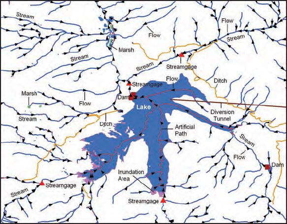
The National Hydrography Dataset (NHD) is a feature-based database that interconnects and uniquely identifies the stream segments or reaches that make up the nation's surface water drainage system. NHD data was originally developed at 1:100,000-scale and exists at that scale for the whole country. This high-resolution NHD, generally developed at 1:24,000/1:12,000 scale, adds detail to the original 1:100,000-scale NHD. (Data for Alaska, Puerto Rico and the Virgin Islands was developed at high-resolution, not 1:100,000 scale.) Local resolution NHD is being developed where partners and data exist. The NHD contains reach codes for networked features, flow direction, names, and centerline representations for areal water...
Categories: Data;
Types: Downloadable;
Tags: Artificial Path,
Canal / Ditch,
FWHydrography,
Gaging Station,
Hydrography,
The National Hydrography Dataset (NHD) is a feature-based database that interconnects and uniquely identifies the sream segments or reaches that comprise the nation's surface water drainage system. Medium resolution NHD is based on the content of the U.S. Geological Survey 1:100,000-scale Digital Line Graph (DLG) hydrography data, integrated with reach-related information from the U.S. Environmental Protection Agency Reach File Version 3.0 (RF3). More specifically, it contains reach codes for networked features and isolated lakes, flow direction, names, stream level, and centerline representations for areal water bodies. Reaches are also defined to represent water bodies and the approximate shorelines of the Great...
Streams and their surrounding catchments exchange water and solutes on a range of physical scales. Exchange with the stream may extend into the interstitial areas of the streambed, the hyporheic zone, the riparian area, or the catchment's groundwater flow system. Even at the smaller scales, the exchanges significantly influence solute transport, nutrient cycling, and the aquatic ecosystem. Over the recent decades, considerable attention has been given to the solute transport aspects of stream–groundwater interactions. Stream–groundwater interactions are now being recognized as practical matters to be considered in environmental issues, such as stream restoration and fish habitat. In this chapter, the emphasis is...
Categories: Publication;
Types: Citation;
Tags: Aquatic ecosystem,
Catchment,
Gaining stream,
Groundwater,
Hyporheic,
Digital flood-inundation maps were created by the U.S. Geological Survey (USGS) in cooperation with the Bandera County River Authority and Groundwater District and with the Texas Water Development Board for a 23-mile reach of the Medina River extending from Winans Creek to English Crossing, Texas. The flood-inundation maps represent a range of selected water-surface elevations at USGS streamflow-gaging station 08178880 Medina River at Bandera, Texas (hereinafter referred to as the “Bandera station”). In this study, flood profiles were computed for the stream reach by means of a one-dimensional step-backwater model HEC-RAS (Hydrologic Engineering Center River Analysis System) (Davidian, 1984; U.S. Army Corps of Engineers,...
Velocity and water-quality surveys were completed along an approximately 71-mile reach of the Ohio River between Markland Locks and Dam (river mile 531.5) and McAlpine Locks and Dam (river mile 606.8) on October 27–November 4, 2016 (survey #1), and June 26–29, 2017 (survey #2). Water-quality data collected in this reach included surface measurements and vertical profiles of water temperature, specific conductance, pH, dissolved oxygen, turbidity, chlorophyll, and phycocyanin. Streamflow and velocity data were collected simultaneous to the water-quality data at cross-sections and along longitudinal lines (corresponding to the water-quality surface measurements) and at selected stationary locations (corresponding...
Categories: Data;
Tags: Indiana,
Kentucky,
Louisville,
Markland Locks and Dam,
McAlpine Locks and Dam,
Velocity and water-quality surveys were completed along an approximately 71-mile reach of the Ohio River between Markland Locks and Dam (river mile 531.5) and McAlpine Locks and Dam (river mile 606.8) on October 27–November 4, 2016 (survey #1), and June 26–29, 2017 (survey #2). Water-quality data collected in this reach included surface measurements and vertical profiles of water temperature, specific conductance, pH, dissolved oxygen, turbidity, chlorophyll, and phycocyanin. Streamflow and velocity data were collected simultaneous to the water-quality data at cross-sections and along longitudinal lines (corresponding to the water-quality surface measurements) and at selected stationary locations (corresponding...
|

|
