Filters: Tags: river basin (X)
25 results (12ms)|
Filters
Date Range
Extensions Types
Contacts
Categories Tag Types
|
The U.S. Geological Survey (USGS) developed a systematic, quantitative approach to prioritize candidate basins that can support the assessment and forecasting objectives of the major USGS water science programs. Candidate basins were the level-4 hydrologic units (HUC4) with some of the smaller HUC4s being combined (hereafter referred to as modified HUC4 basins). Candidate basins for the contiguous United States (CONUS) were grouped into 18 hydrologic regions. Thirty-three geospatial variables representing land use, climate change, water use, water-balance components, streamflow alteration, fire risk, and ecosystem sensitivity were initially considered to assist in ranking candidate basins for study. The two highest...
Categories: Data;
Tags: Climatology,
Ecology,
Hydrology,
Integrated Water Science Basins,
Land Use Change,

These data were released prior to the October 1, 2016 effective date for the USGS’s policy dictating the review, approval, and release of scientific data as referenced in USGS Survey Manual Chapter 502.8 Fundamental Science Practices: Review and Approval of Scientific Data for Release. This dataset consists of drainage basin boundaries for 212 U.S. Geological Survey (USGS) stream sites sampled in the National Water-Quality Assessment (NAWQA) Program, the National Stream Quality Accounting Network (NASQAN), and the National Monitoring Network (NMN). Of the 212 sites, 206 have either a contributing or total drainage basin boundary, and the remaining 6 have both a total drainage basin boundary and a smaller contributing...
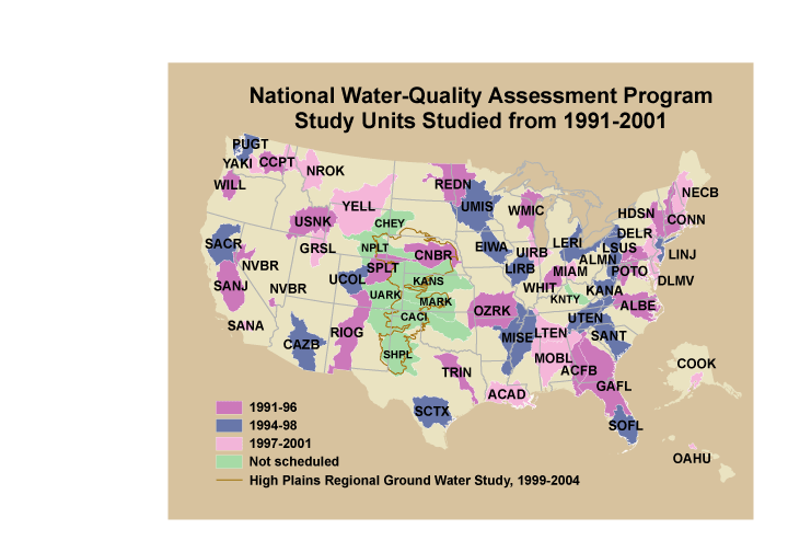
These data were released prior to the October 1, 2016 effective date for the USGS’s policy dictating the review, approval, and release of scientific data as referenced in USGS Survey Manual Chapter 502.8 Fundamental Science Practices: Review and Approval of Scientific Data for Release. This is a GENERALIZED version of the boundaries and codes used for the U.S. Geological Survey's National Water-Quality Assessment (NAWQA) Program Study-Unit investigations in the conterminous United States, excluding the High Plains Regional Ground-Water Study. The data set represents the areas studied during the first decade of the NAWQA Program, from 1991-2001 ("cycle 1"). The coverage is intended only for drawing ILLUSTRATIONS,...
This dataset provides compiled and computed data from 1900 through 2017 associated with streamflow statistics used to perform regional analyses for the Brazos, Colorado, Big Cypress, Guadalupe, Neches, Sulphur, and Trinity River Basins. These seven river basins are mostly within Texas, but parts of some of the basins extend into New Mexico and Louisiana. Because changes in precipitation, temperature and groundwater levels can appreciably affect streamflow, understanding changes in streamflow requires taking these forcing variables into account. Long-term streamflow statistics for these seven river basins were derived by analyzing streamflow data and other observed climatological variables. Data include tables of...
These data were released prior to the October 1, 2016 effective date for the USGS’s policy dictating the review, approval, and release of scientific data as referenced in USGS Survey Manual Chapter 502.8 Fundamental Science Practices: Review and Approval of Scientific Data for Release. As part of the U.S. Geological Survey's National Water-Quality Assessment Program, an investigation of the Yellowstone River Basin study unit is being conducted to document status and trends in surface- and ground-water quality. Surface-water samples are collected from streams (or lakes) at specific sampling stations. Water-quality characteristics at each station are influenced by the natural and cultural characteristics of the drainage...
This CSV file contains 21 dam metrics representing stream fragmentation and flow alteration for nearly 2.3 million stream reaches in the conterminous USA. Dam metrics fall into four main categories: segment-based, count and density, distance-based, and cumulative reservoir storage (described below). These data were developed using spatially verified large dam locations (n=49,468) primarily from the National Anthropogenic Barrier Dataset (NABD) that were spatially linked to the National Hydrography Dataset Plus version 1 (NHDPlusV1). These dam metrics have been summarized using the unique identifier field native to the NHDPlusV1 (COMID) which can be used to join this table to spatial layers and data tables of the...
Categories: Data;
Types: Citation;
Tags: 2015 National Assessment,
2015 National Assessment,
2015 National Assessment,
Alabama,
Arizona,
This CSV file contains landscape factors representing anthropogenic disturbances to stream habitats summarized within 6th level Hydrologic Unit Code (HUC12) watersheds of the Watershed Boundary Dataset. The source datasets compiled and attributed to spatial units were identified as being: (1) meaningful for assessing fluvial fish habitat; (2) consistent across the entire study area in the way that they were assembled; (3) broadly representative of conditions in the past 10 years, and (4) of sufficient spatial resolution that they could be used to make valid comparisons among local catchment units. Variables summarized at the HUC12 scale include measures of anthropogenic land uses, population density, roads, dams,...
Categories: Data;
Types: ArcGIS REST Map Service,
ArcGIS Service Definition,
Downloadable,
Map Service;
Tags: 2015 National Assessment,
2015 National Assessment,
Alaska,
Anthropogenic factors,
DataProduct,
The coastal region which includes areas within South Carolina and North Carolina was chosen as a focus area study (FAS) for the U.S. Geological Survey (USGS) National Water Census (NWC) in 2016. The objective of the NWC is to place technical information and tools in the hands of stake holders so that they can make informed decisions on water availability. The USGS South Atlantic Water Science Center, comprised of North Carolina, South Carolina, and Georgia, conducted a 3-year study of water use and availability, climate change, and population growth to provide information related to the competing societal and ecological water needs in the Southeastern Atlantic Coastal Basins of the Carolinas. The Coastal Carolinas...
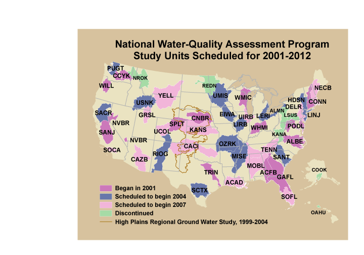
These data were released prior to the October 1, 2016 effective date for the USGS’s policy dictating the review, approval, and release of scientific data as referenced in USGS Survey Manual Chapter 502.8 Fundamental Science Practices: Review and Approval of Scientific Data for Release. This is a GENERALIZED version of the boundaries and codes used for the U.S. Geological Survey's National Water-Quality Assessment (NAWQA) Program Study-Unit investigations in the conterminous United States, excluding the High Plains Regional Ground-Water Study. The data set represents the areas to be studied during the second decade of the NAWQA Program, from 2001-2012 ("cycle 2"). The coverage is intended only for drawing ILLUSTRATIONS,...
This CSV file contains landscape factors representing anthropogenic disturbances to stream habitats summarized within local and network stream catchments as well as 90 m local and network buffer of stream reaches throughout the conterminous U.S. The source datasets compiled and attributed to spatial units were identified as being: (1) meaningful for assessing fluvial fish habitat; (2) consistent across the entire study area in the way that they were assembled; (3) broadly representative of conditions in the past 10 years, and (4) of sufficient spatial resolution that they could be used to make valid comparisons among local catchment units. Variables summarized at the catchment scale include measures of anthropogenic...
Categories: Data;
Types: Citation;
Tags: Alabama,
Anthropogenic factors,
Arizona,
Arkansas,
California,
These data were released prior to the October 1, 2016 effective date for the USGS’s policy dictating the review, approval, and release of scientific data as referenced in USGS Survey Manual Chapter 502.8 Fundamental Science Practices: Review and Approval of Scientific Data for Release. This is a coverage of the boundaries and codes used for the U.S. Geological Survey's National Water-Quality Assessment (NAWQA) Program Study-Unit investigations in the conterminous United States, excluding the High Plains Regional Ground-Water Study. The data set represents the areas to be studied during the second cycle of the NAWQA Program, from 2001-2012 ("cycle 2").
These data were released prior to the October 1, 2016 effective date for the USGS’s policy dictating the review, approval, and release of scientific data as referenced in USGS Survey Manual Chapter 502.8 Fundamental Science Practices: Review and Approval of Scientific Data for Release. As part of the U.S. Geological Survey's National Water-Quality Assessment Program, an investigation of the Yellowstone River Basin study unit is being conducted to document status and trends in surface- and ground-water quality. Surface-water samples are collected from streams or lakes at specific sampling stations. Water-quality characteristics at each station are influenced by the natural and cultural characteristics of the drainage...
Categories: pre-SM502.8;
Tags: Montana,
NSDI,
North Dakota,
USGS Science Data Catalog (SDC),
Wyoming,
These data were released prior to the October 1, 2016 effective date for the USGS’s policy dictating the review, approval, and release of scientific data as referenced in USGS Survey Manual Chapter 502.8 Fundamental Science Practices: Review and Approval of Scientific Data for Release. This is a coverage of the boundaries and codes used for the U.S. Geological Survey's National Water-Quality Assessment (NAWQA) Program Study-Unit investigations in the conterminous United States, excluding the High Plains Regional Ground-Water Study. The data set represents the areas studied during the first decade of the NAWQA Program, from 1991-2001 ("cycle 1").
Categories: pre-SM502.8;
Tags: Aquifer system,
Conterminous United States,
Ground water,
NAWQA,
NSDI,
All stream or river-channel flows are time variant, or unsteady, in a different degree; steady flow is but an exception rather than the rule. These flows usually exist in different states, such as sub-critical, super-critical, and trans-critical flows. Alternative terms for different flow conditions are often used, such as continuous or discontinuous flows, flows through hydraulic jump or through channel constriction. A river basin, the basic geometric unit of the surface-water flow configurations, generally contains river reaches, branches, tributaries, junctions, and networks. Reasonable and rational definition and determination of all-weather, river-basin, unsteady flows, letting the last three quantifiers...
Categories: Project;
Tags: Computer Simulation,
Estuarine Flows,
Flood Flows,
Numerical Modeling,
River Basin,

These data were released prior to the October 1, 2016 effective date for the USGS’s policy dictating the review, approval, and release of scientific data as referenced in USGS Survey Manual Chapter 502.8 Fundamental Science Practices: Review and Approval of Scientific Data for Release. This data set consists of 204 drainage basin boundaries for U.S. Geological Survey's (USGS) stream sites sampled in the National Water Quality Assessment (NAWQA) Program and the National Stream Quality Accounting Network (NASQAN). These drainage basin boundaries are used to generate watershed characteristics for the development of water-quality models. The basin boundaries were collected from USGS hydrologists and geographers from...
Categories: pre-SM502.8;
Tags: Conterminous United States,
NASQAN,
NAWQA,
NSDI,
National Stream Quality Accounting Network,
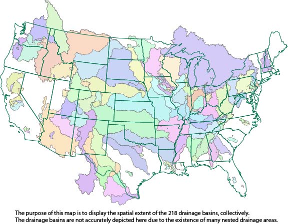
This dataset consists of drainage basin boundaries for 212 U.S. Geological Survey (USGS) stream sites sampled in the National Water-Quality Assessment (NAWQA) Program, the National Stream Quality Accounting Network (NASQAN), and the National Monitoring Network (NMN). Of the 212 sites, 206 have either a contributing or total drainage basin boundary, and the remaining 6 have both a total drainage basin boundary and a smaller contributing basin boundary. Collectively, these 218 basin boundaries have been used in a geographic information system (GIS) to generate basin characteristics for the assessment of trends in concentrations of pesticides streams of the United States.
This shapefile contains cumulative fish habitat condition index (HCI) scores and specific disturbance indices for local and network stream catchments as well as the downstream main channel catchment of perennial and intermittent streams reaches of the five main island of Hawai'i. In this dataset indices are linked to the Hawaii Fish Habitat Partnership (HFHP) stream layer (Tingley et al. in prep) which is a modified version of the 1:24,000 National Hydrography Dataset. It includes 11,436 intermittent and perennial stream reaches across the five main Hawaiian Islands (Hawai’i, Maui, Moloka’i, O’ahu, Kaua’i). Catchment attributes are available for both local catchments (defined as the land area draining directly to...
Categories: Data;
Types: ArcGIS REST Map Service,
Citation,
Map Service;
Tags: 2015 National Assessment,
2015 National Assessment,
Anthropogenic factors,
DataProduct,
Direct habitat alteration,

These data were released prior to the October 1, 2016 effective date for the USGS’s policy dictating the review, approval, and release of scientific data as referenced in USGS Survey Manual Chapter 502.8 Fundamental Science Practices: Review and Approval of Scientific Data for Release. This data set contains 204 drainage basin boundaries for U.S. Geological Survey (USGS) stream sites analyzed in the Watershed Regressions for Pesticides (WARP) model. This dataset supercedes version 1.0 released in April 2010, and consists of revisions to 26 basin boundaries.
Categories: pre-SM502.8;
Tags: Conterminous United States,
NAWQA,
NSDI,
National Water Quality Assessment,
USGS Science Data Catalog (SDC),
The concept of a river basin as a management or planning unit has gone through several stages and is in a state of flux. From its western ?discovery? in the 18th century to its advent as the overriding concept behind European water policy, the river basin has been conjured up and mobilized in evolving contexts with varying intentions. Associated with utopian ideas of the late 19th century, it supported ideas of full control of the hydrologic regime and multipurpose dam construction in the 1930?1960 period, then partly faded and was revived to address water-quality problems, before reemerging in the 1990s as the cornerstone of Integrated Water Resources Management (IWRM), enriched and blended with watershed- and...
Categories: Publication;
Types: Citation,
Journal Citation;
Tags: Geoforum,
domination of nature,
integrated water management,
river basin
This imagery dataset consists of 3-meter resolution, lidar-derived imagery of the Honesdale 30 x 60 minute quadrangle in Pennsylvania and part of New York. It also covers part of the Delaware River Basin. The source data used to construct this imagery consists of 1-meter resolution lidar-derived digital elevation models (DEMs). The lidar source data were compiled from different acquisitions published between 2017 and 2019 from the Pennsylvania Spatial Data Access (PASDA). The data were processed using geographic information systems (GIS) software. The data is projected in North America Datum (NAD) UTM Zone 18 North. This representation illustrates the terrain as a hillshade with contrast adjusted to highlight local...
Categories: Data;
Tags: Delaware River Basin,
Geography,
Geomorphology,
Lidar,
USGS Science Data Catalog (SDC),
|

|
