Filters: Tags: sea ice (X) > partyWithName: Conservation Biology Institute (X)
78 results (7ms)|
Filters
Date Range
Tag Schemes |

The National Environmental Satellite, Data, and Information Service (NESDIS), part of the National Oceanic and Atmospheric Administration (NOAA), has an extensive history of monitoring snow and ice coverage. Accurate monitoring of global snow and ice cover is a key component in the study of climate and global change as well as daily weather forecasting. By inspecting environmental satellite imagery, analysts from the Satellite Analysis Branch (SAB) at the Office of Satellite Data Processing and Distribution (OSDPD), Satellite Services Division (SSD), created a Northern Hemisphere snow and ice map from November 1966 until the National Ice Center (NIC) took over production in 2008. Initially, the product was produced...
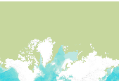
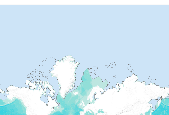
The Multisensor Analyzed Sea Ice Extent – Northern Hemisphere (MASIE-NH) products provide measurements of daily sea ice extent and sea ice edge boundary for the Northern Hemisphere and 16 Arctic regions in a polar stereographic projection. Products include an ASCII text file of sea ice extent values in square km over the entire Northern Hemisphere with 16 separate Arctic regions identified, time series plots of the 16 regions, and image files that visually show where the sea ice is. The MASIE-NH imagery are provided at a nominal 4 km resolution. The input data comes from the 4 km Interactive Multisensor Snow and Ice Mapping System (IMS) snow and ice product produced by the National Ice Center (NIC). NIC utilizes...

The National Environmental Satellite, Data, and Information Service (NESDIS), part of the National Oceanic and Atmospheric Administration (NOAA), has an extensive history of monitoring snow and ice coverage. Accurate monitoring of global snow and ice cover is a key component in the study of climate and global change as well as daily weather forecasting. By inspecting environmental satellite imagery, analysts from the Satellite Analysis Branch (SAB) at the Office of Satellite Data Processing and Distribution (OSDPD), Satellite Services Division (SSD), created a Northern Hemisphere snow and ice map from November 1966 until the National Ice Center (NIC) took over production in 2008. Initially, the product was produced...

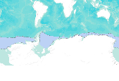
The Sea Ice Index provides a quick look at sea ice changes in spatial and historical context and gives a consistent, up-to-date source of sea ice extent and sea ice concentration values and images. The NSIDC Near-Real-Time DMSP SSM/I Daily Polar Gridded Sea Ice Concentrations and the Sea Ice Concentrations from Nimbus-7 SSMR and DMSP SSM/I Passive Microwave Data data sets are used to generate the monthly records of sea ice extent and sea ice concentration for the Arctic and Antarctica from satellite passive microwave data. Data files tabulate monthly mean extent and area, in millions of square kilometers, by year for a given month. Plots of monthly sea ice extent anomalies with trend lines and significance intervals...

The Sea Ice Index provides a quick look at sea ice changes in spatial and historical context and gives a consistent, up-to-date source of sea ice extent and sea ice concentration values and images. The NSIDC Near-Real-Time DMSP SSM/I Daily Polar Gridded Sea Ice Concentrations and the Sea Ice Concentrations from Nimbus-7 SSMR and DMSP SSM/I Passive Microwave Data data sets are used to generate the monthly records of sea ice extent and sea ice concentration for the Arctic and Antarctica from satellite passive microwave data. Data files tabulate monthly mean extent and area, in millions of square kilometers, by year for a given month. Plots of monthly sea ice extent anomalies with trend lines and significance intervals...

The Sea Ice Index provides a quick look at sea ice changes in spatial and historical context and gives a consistent, up-to-date source of sea ice extent and sea ice concentration values and images. The NSIDC Near-Real-Time DMSP SSM/I Daily Polar Gridded Sea Ice Concentrations and the Sea Ice Concentrations from Nimbus-7 SSMR and DMSP SSM/I Passive Microwave Data data sets are used to generate the monthly records of sea ice extent and sea ice concentration for the Arctic and Antarctica from satellite passive microwave data. Data files tabulate monthly mean extent and area, in millions of square kilometers, by year for a given month. Plots of monthly sea ice extent anomalies with trend lines and significance intervals...

The Sea Ice Index provides a quick look at sea ice changes in spatial and historical context and gives a consistent, up-to-date source of sea ice extent and sea ice concentration values and images. The NSIDC Near-Real-Time DMSP SSM/I Daily Polar Gridded Sea Ice Concentrations and the Sea Ice Concentrations from Nimbus-7 SSMR and DMSP SSM/I Passive Microwave Data data sets are used to generate the monthly records of sea ice extent and sea ice concentration for the Arctic and Antarctica from satellite passive microwave data. Data files tabulate monthly mean extent and area, in millions of square kilometers, by year for a given month. Plots of monthly sea ice extent anomalies with trend lines and significance intervals...

The Sea Ice Index provides a quick look at sea ice changes in spatial and historical context and gives a consistent, up-to-date source of sea ice extent and sea ice concentration values and images. The NSIDC Near-Real-Time DMSP SSM/I Daily Polar Gridded Sea Ice Concentrations and the Sea Ice Concentrations from Nimbus-7 SSMR and DMSP SSM/I Passive Microwave Data data sets are used to generate the monthly records of sea ice extent and sea ice concentration for the Arctic and Antarctica from satellite passive microwave data. Data files tabulate monthly mean extent and area, in millions of square kilometers, by year for a given month. Plots of monthly sea ice extent anomalies with trend lines and significance intervals...

The Sea Ice Index provides a quick look at sea ice changes in spatial and historical context and gives a consistent, up-to-date source of sea ice extent and sea ice concentration values and images. The NSIDC Near-Real-Time DMSP SSM/I Daily Polar Gridded Sea Ice Concentrations and the Sea Ice Concentrations from Nimbus-7 SSMR and DMSP SSM/I Passive Microwave Data data sets are used to generate the monthly records of sea ice extent and sea ice concentration for the Arctic and Antarctica from satellite passive microwave data. Data files tabulate monthly mean extent and area, in millions of square kilometers, by year for a given month. Plots of monthly sea ice extent anomalies with trend lines and significance intervals...

The Sea Ice Index provides a quick look at sea ice changes in spatial and historical context and gives a consistent, up-to-date source of sea ice extent and sea ice concentration values and images. The NSIDC Near-Real-Time DMSP SSM/I Daily Polar Gridded Sea Ice Concentrations and the Sea Ice Concentrations from Nimbus-7 SSMR and DMSP SSM/I Passive Microwave Data data sets are used to generate the monthly records of sea ice extent and sea ice concentration for the Arctic and Antarctica from satellite passive microwave data. Data files tabulate monthly mean extent and area, in millions of square kilometers, by year for a given month. Plots of monthly sea ice extent anomalies with trend lines and significance intervals...

The Sea Ice Index provides a quick look at sea ice changes in spatial and historical context and gives a consistent, up-to-date source of sea ice extent and sea ice concentration values and images. The NSIDC Near-Real-Time DMSP SSM/I Daily Polar Gridded Sea Ice Concentrations and the Sea Ice Concentrations from Nimbus-7 SSMR and DMSP SSM/I Passive Microwave Data data sets are used to generate the monthly records of sea ice extent and sea ice concentration for the Arctic and Antarctica from satellite passive microwave data. Data files tabulate monthly mean extent and area, in millions of square kilometers, by year for a given month. Plots of monthly sea ice extent anomalies with trend lines and significance intervals...

The Sea Ice Index provides a quick look at sea ice changes in spatial and historical context and gives a consistent, up-to-date source of sea ice extent and sea ice concentration values and images. The NSIDC Near-Real-Time DMSP SSM/I Daily Polar Gridded Sea Ice Concentrations and the Sea Ice Concentrations from Nimbus-7 SSMR and DMSP SSM/I Passive Microwave Data data sets are used to generate the monthly records of sea ice extent and sea ice concentration for the Arctic and Antarctica from satellite passive microwave data. Data files tabulate monthly mean extent and area, in millions of square kilometers, by year for a given month. Plots of monthly sea ice extent anomalies with trend lines and significance intervals...
The Sea Ice Index provides a quick look at sea ice changes in spatial and historical context and gives a consistent, up-to-date source of sea ice extent and sea ice concentration values and images. The NSIDC Near-Real-Time DMSP SSM/I Daily Polar Gridded Sea Ice Concentrations and the Sea Ice Concentrations from Nimbus-7 SSMR and DMSP SSM/I Passive Microwave Data data sets are used to generate the monthly records of sea ice extent and sea ice concentration for the Arctic and Antarctica from satellite passive microwave data. Data files tabulate monthly mean extent and area, in millions of square kilometers, by year for a given month. Plots of monthly sea ice extent anomalies with trend lines and significance intervals...

The Sea Ice Index provides a quick look at sea ice changes in spatial and historical context and gives a consistent, up-to-date source of sea ice extent and sea ice concentration values and images. The NSIDC Near-Real-Time DMSP SSM/I Daily Polar Gridded Sea Ice Concentrations and the Sea Ice Concentrations from Nimbus-7 SSMR and DMSP SSM/I Passive Microwave Data data sets are used to generate the monthly records of sea ice extent and sea ice concentration for the Arctic and Antarctica from satellite passive microwave data. Data files tabulate monthly mean extent and area, in millions of square kilometers, by year for a given month. Plots of monthly sea ice extent anomalies with trend lines and significance intervals...

The Sea Ice Index provides a quick look at sea ice changes in spatial and historical context and gives a consistent, up-to-date source of sea ice extent and sea ice concentration values and images. The NSIDC Near-Real-Time DMSP SSM/I Daily Polar Gridded Sea Ice Concentrations and the Sea Ice Concentrations from Nimbus-7 SSMR and DMSP SSM/I Passive Microwave Data data sets are used to generate the monthly records of sea ice extent and sea ice concentration for the Arctic and Antarctica from satellite passive microwave data. Data files tabulate monthly mean extent and area, in millions of square kilometers, by year for a given month. Plots of monthly sea ice extent anomalies with trend lines and significance intervals...

The Sea Ice Index provides a quick look at sea ice changes in spatial and historical context and gives a consistent, up-to-date source of sea ice extent and sea ice concentration values and images. The NSIDC Near-Real-Time DMSP SSM/I Daily Polar Gridded Sea Ice Concentrations and the Sea Ice Concentrations from Nimbus-7 SSMR and DMSP SSM/I Passive Microwave Data data sets are used to generate the monthly records of sea ice extent and sea ice concentration for the Arctic and Antarctica from satellite passive microwave data. Data files tabulate monthly mean extent and area, in millions of square kilometers, by year for a given month. Plots of monthly sea ice extent anomalies with trend lines and significance intervals...

The Sea Ice Index provides a quick look at sea ice changes in spatial and historical context and gives a consistent, up-to-date source of sea ice extent and sea ice concentration values and images. The NSIDC Near-Real-Time DMSP SSM/I Daily Polar Gridded Sea Ice Concentrations and the Sea Ice Concentrations from Nimbus-7 SSMR and DMSP SSM/I Passive Microwave Data data sets are used to generate the monthly records of sea ice extent and sea ice concentration for the Arctic and Antarctica from satellite passive microwave data. Data files tabulate monthly mean extent and area, in millions of square kilometers, by year for a given month. Plots of monthly sea ice extent anomalies with trend lines and significance intervals...
The Sea Ice Index provides a quick look at sea ice changes in spatial and historical context and gives a consistent, up-to-date source of sea ice extent and sea ice concentration values and images. The NSIDC Near-Real-Time DMSP SSM/I Daily Polar Gridded Sea Ice Concentrations and the Sea Ice Concentrations from Nimbus-7 SSMR and DMSP SSM/I Passive Microwave Data data sets are used to generate the monthly records of sea ice extent and sea ice concentration for the Arctic and Antarctica from satellite passive microwave data. Data files tabulate monthly mean extent and area, in millions of square kilometers, by year for a given month. Plots of monthly sea ice extent anomalies with trend lines and significance intervals...

The Sea Ice Index provides a quick look at sea ice changes in spatial and historical context and gives a consistent, up-to-date source of sea ice extent and sea ice concentration values and images. The NSIDC Near-Real-Time DMSP SSM/I Daily Polar Gridded Sea Ice Concentrations and the Sea Ice Concentrations from Nimbus-7 SSMR and DMSP SSM/I Passive Microwave Data data sets are used to generate the monthly records of sea ice extent and sea ice concentration for the Arctic and Antarctica from satellite passive microwave data. Data files tabulate monthly mean extent and area, in millions of square kilometers, by year for a given month. Plots of monthly sea ice extent anomalies with trend lines and significance intervals...

The Sea Ice Index provides a quick look at sea ice changes in spatial and historical context and gives a consistent, up-to-date source of sea ice extent and sea ice concentration values and images. The NSIDC Near-Real-Time DMSP SSM/I Daily Polar Gridded Sea Ice Concentrations and the Sea Ice Concentrations from Nimbus-7 SSMR and DMSP SSM/I Passive Microwave Data data sets are used to generate the monthly records of sea ice extent and sea ice concentration for the Arctic and Antarctica from satellite passive microwave data. Data files tabulate monthly mean extent and area, in millions of square kilometers, by year for a given month. Plots of monthly sea ice extent anomalies with trend lines and significance intervals...
|

|
