Filters: Tags: seeps (X)
12 results (281ms)|
Filters
Date Range
Extensions Types
Contacts
Categories Tag Types
|
FY2014This project builds upon the springs and seeps inventory funded by the Desert LCC.This project will: Fill a significant gap in aquatic habitat information for scenario planning. Create a publically available geospatial database of approximately 2,000+ known Great Basin springs. Create a summary report on the biotic and abiotic conditions of the known springs.
Categories: Data,
Project;
Types: Map Service,
OGC WFS Layer,
OGC WMS Layer,
OGC WMS Service;
Tags: Academics & scientific researchers,
California,
California,
California,
California,
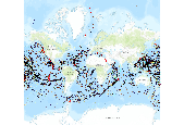
Seamounts and vents map citation: Kitchingman and Lai 2004, Ramirez-Llodra and Baker 2006. Map data source: Kitchingman, A. and S. Lai. 2004. âInferences on potential seamount locations from mid-resolution bathymetric data.â In: Morato T, Pauly D (eds) Seamounts: Biodiversity and Fisheries. Fisheries Centre, University of British Colombia, Vancouver, Canada, pp 7-12 Ramirez-Llodra, E. and M.C. Baker. 2006. Data on the location of hydrothermal vents. Biogeography of Chemosynthetic Ecosystems (ChEss) Project (www.noc.soton.ac.uk/chess). Map Technical Notes Locations of seamounts are from (Kitchingman and Lai 2004) and were developed from a global GIS based analysis, which identifies a total of 14,000 seamounts....
Developing a Geodatabase and Geocollaborative Tools to Support Springs and Springs Dependent Species
The Museum of Northern Arizona will leverage tools previously developed through its Springs Stewardship Initiative to help resource managers in the southwestern U.S. collect, analyze, report upon, monitor and archive the complex and inter-related information associated with springs and spring-dependent species in the region. Building upon those past efforts, the project will include compilation of existing springs-related information to make the information more readily available online and further development of interactive online maps and climate change risk assessment tools of springs-dependent sensitive plant and animal species. This project builds on an effort funded in FY 2013 to complete similar work for...
Categories: Data,
Project;
Types: Map Service,
OGC WFS Layer,
OGC WMS Layer,
OGC WMS Service;
Tags: AZ-01,
AZ-04,
Arizona,
CO-02,
CO-03,
This map shows the status of aquatic ecosystems, in addition to the input datasets used for the analysis and distribution modeling that were involved in producing these status datasets. These data are provided by Bureau of Land Management (BLM) "as is" and may contain errors or omissions. The User assumes the entire risk associated with its use of these data and bears all responsibility in determining whether these data are fit for the User's intended use. These data may not have the accuracy, resolution, completeness, timeliness, or other characteristics appropriate for applications that potential users of the data may contemplate. The User is encouraged to carefully consider the content of the metadata file associated...
Comparison of springs and HUC 12 watersheds where groundwater use is exceeding recharge. These data are provided by Bureau of Land Management (BLM) "as is" and may contain errors or omissions. The User assumes the entire risk associated with its use of these data and bears all responsibility in determining whether these data are fit for the User's intended use. These data may not have the accuracy, resolution, completeness, timeliness, or other characteristics appropriate for applications that potential users of the data may contemplate. The User is encouraged to carefully consider the content of the metadata file associated with these data. The BLM should be cited as the data source in any products derived from...
Environmental conditions recorded at 2,256 Great Basin and Mojave Desert springs that were inventoried from the late 1980s into 2013 are summarized. These records provide information about individual springs and their spatial variability across the landscape. Insight into their changing condition is provided by records compiled at springs visited several times over more than 20 years. Although this summary considers a small proportion of springs in this region, it provides broad insight into their size, basic water chemistry, and conditions that are indicative of springs over a large portion of the southwestern US.
In September 2013 the Springs Stewardship Institute received funding from the BOR to map springs and springs-dependent species in the DLCC. Since then we have configured our server, migrated our geodatabase to an ArcSDE, and published several WMS and WFS to our domain at https://arcgis.springsdata.org/arcgis/rest/services . This includes a WMS of springs in the DLCC that we have also made available through ArcGIS Online at http://bit.ly/1k6zo7p . We have also migrated our non-spatial survey data to an online application at http://springsdata.org/index.php . This is a user-friendly interface for a MySQL database that includes georeferencing, geomorphology, flow, flora, fauna, water quality, and condition assessment...
Museum of Northern Arizona, Inc. will leverage tools previously developed by the Springs Stewardship Initiative to help resource managers in the southwestern U.S. collect, analyze, report upon, monitor and archive the complex and interrelated information associated with springs and spring-dependent species in the region. The information will be compiled and made readily available online. The Museum will further develop interactive online maps and climate change risk assessment tools of springs-dependent sensitive plant and animal species.
Categories: Data,
Project;
Types: Downloadable,
Map Service,
OGC WFS Layer,
OGC WMS Layer,
OGC WMS Service,
Shapefile;
Tags: 2013,
AL-05,
AZ-01,
AZ-02,
AZ-03,
This map shows the status of aquatic ecosystems, in addition to the input datasets used for the analysis and distribution modeling that were involved in producing these status datasets. These data are provided by Bureau of Land Management (BLM) "as is" and may contain errors or omissions. The User assumes the entire risk associated with its use of these data and bears all responsibility in determining whether these data are fit for the User's intended use. These data may not have the accuracy, resolution, completeness, timeliness, or other characteristics appropriate for applications that potential users of the data may contemplate. The User is encouraged to carefully consider the content of the metadata file associated...
Wetland mapping is conducted in defined geographic areas called projects. Imagery is used as the base information to define the type and location of each wetland. The scale, type and date of imagery used in a project is provided in a pop-up window when a wetland polygon is selected on the Wetlands Mapper. Investigators that complete a wetland mapping project record information on the source imagery, collateral data, inventory method, data limitations, geographic features, landforms, wetland types and other specifics in a project metadata document. Wetland identification and interpretation was done “heads-up” using ArcMap versions 10.2-11.0. US Fish & Wildlife Service (USFWS) National Wetlands Inventory (NWI) mapping...
Categories: Data;
Tags: Data,
EARTH SCIENCE > LAND SURFACE > LANDSCAPE,
GRSG,
Great Basin,
LCC Network Science Catalog,
FY2014The purpose of this project is to develop a series of high resolution (1:24,000 scale) digital wetland maps and associated data to support conservation planning in Nevada.FY2015The purpose of this project is to develop a series of high resolution (1:24,000 scale) digital wetland maps and associated data to support conservation planning in Nevada.
Categories: Data,
Project;
Types: Map Service,
OGC WFS Layer,
OGC WMS Layer,
OGC WMS Service;
Tags: Applications and Tools,
Datasets/Database,
Federal resource managers,
GRSG,
GRSG,
On April 13, 2015, the Great Basin LCC hosted a webinar about new Sage-Grouse conservation data presented by the National Wetlands Inventory.Nevada’s wetlands are important havens for local wildlife. Past and current changes in climate and land use practices have stressed many sensitive wetland systems across Nevada, putting the wildlife they support at risk. For greater sage-grouse, wetlands also play an important role in providing brood rearing habitat. This project is mapping areas of high priority sage grouse habitat in Nevada and will move towards mapping areas of other wetlands in future years with additional funding. Mapping of other important landscapes such as upland riparian habitat are also part of this...
Categories: Data;
Tags: EARTH SCIENCE > LAND SURFACE > LANDSCAPE,
GRSG,
Great Basin,
LCC Network Science Catalog,
Nevada,
|

|
