Filters: Tags: snowfall (X)
275 results (79ms)|
Filters
Date Range
Extensions Types
Contacts
Categories Tag Types
|

This dataset represents Recharge change, from Basin Characterization Model (BCM) output using the PCM A2 Scenario in northern California, for 2010-2039. The data was processed using historic Recharge (1979-2000) and PCM A2 Scenario Recharge (2010-2039) to calculate change. Recharge: Amount of water exceeding field capacity that enters bedrock, occurs at a rate determined by the hydraulic conductivity of the underlying materials, excess water (rejected recharge) is added to runoff. The California Basin Characterization Model (BCM) climate dataset provides historical and projected climate surfaces for the state at a 270 meter resolution. The historical data is based on 4 kilometer PRISM data, and the projected...

This dataset represents Climatic Water Deficit (CWD) change, from Basin Characterization Model (BCM) output using the PCM A2 Scenario in northern Sierra Nevada California, for 2040-2069. The data was processed using historic CWD (1979-2000) and CWD (2040-2069) to calculate change. The term climatic water deficit defined by Stephenson (1998) is quantified as the amount of water by which potential evapotranspiration (PET) exceeds actual evapotranspiration (AET). This term effectively integrates the combined effects of solar radiation, evapotranspiration, and air temperature on watershed conditions given available soil moisture derived from precipitation. Climatic water deficit can be thought of as the amount of...

This dataset is a Basin Characterization Model (BCM) output using the GFDL A2 Scenario for annual runoff, 2010-2039, clipped to the DRECP 12 km buffered boundary. Runoff: Amount of water that becomes stream flow, summed annually. Modeled as amount of water that exceeds total soil storage and rejected recharge. The California Basin Characterization Model (BCM) climate dataset provides historical and projected climate surfaces for the state at a 270 meter resolution. The historical data is based on 4 kilometer PRISM data, and the projected climate surfaces are based on the A2 and B1 scenarios of the PCM and GFDL GCMs. The BCM approach uses a regional water balance model based on high resolution downscaled precipitation...

This dataset is a Basin Characterization Model (BCM) output using the GFDL A2 Scenario for mean maximum August temperature, 2070-2099, clipped to the DRECP 12 km buffered boundary.Maximum monthly temperature:Â The maximum monthly temperature, from downscaled GCMThe modeled daily maximum and minimum are averaged to give daily average;Â the maximum daily average in a calendar month becomes the monthly maximum;Â this is averaged over a 30 year period to determine TMax for each month of the year, and for the water year. The California Basin Characterization Model (BCM) climate dataset provides historical and projected climate surfaces for the state at a 270 meter resolution. The historical data is based on 4 kilometer...

This dataset is a Basin Characterization Model (BCM) output using the PCM A2 Scenario for Runoff, in southern Sierra Nevada California, for 2040-2069. Runoff: Amount of water that becomes stream flow, summed annually. Modeled as amount of water that exceeds total soil storage and rejected recharge. The California Basin Characterization Model (BCM) climate dataset provides historical and projected climate surfaces for the state at a 270 meter resolution. The historical data is based on 4 kilometer PRISM data, and the projected climate surfaces are based on the A2 and B1 scenarios of the PCM and GFDL GCMs. The BCM approach uses a regional water balance model based on high resolution downscaled precipitation and...
This dataset is a Basin Characterization Model (BCM) output using the GFDL A2 Scenario for Runoff, in central Sierra Nevada California, for 2070-2099. Runoff: Amount of water that becomes stream flow, summed annually. Modeled as amount of water that exceeds total soil storage and rejected recharge. The California Basin Characterization Model (BCM) climate dataset provides historical and projected climate surfaces for the state at a 270 meter resolution. The historical data is based on 4 kilometer PRISM data, and the projected climate surfaces are based on the A2 and B1 scenarios of the PCM and GFDL GCMs. The BCM approach uses a regional water balance model based on high resolution downscaled precipitation and...
This dataset is a Basin Characterization Model (BCM) output using the PCM A2 Scenario for annual recharge, 2040-2069, clipped to the Sierra Nevada Zones for the CA LCC. Recharge: Amount of water exceeding field capacity that enters bedrock, occurs at a rate determined by the hydraulic conductivity of the underlying materials, excess water (rejected recharge) is added to runoff. The California Basin Characterization Model (BCM) climate dataset provides historical and projected climate surfaces for the state at a 270 meter resolution. The historical data is based on 4 kilometer PRISM data, and the projected climate surfaces are based on the A2 and B1 scenarios of the PCM and GFDL GCMs. The BCM approach uses a regional...
This NetCDF represents the monthly inputs and outputs from a United States Geological Survey water-balance model (McCabe and Wolock, 2011) for the conterminous United States for the period 1895-01-01 to 2020-12-31. The source data used to run the water balance model is based on the National Oceanic and Atmospheric Administration's(Vose and others, 2020) ClimGrid data for precipitation and temperature. This NetCDF contains the following monthly inputs: temperature (degrees Celsius) and precipitation (millimeters, mm) and the following outputs (all in mm): runoff, soil moisture storage, actual evapotranspiration, potential evapotranspiration, snow water equivalent, and snowfall. The spatial reference for this data...

This dataset is a Basin Characterization Model (BCM) output using the GFDL A2 Scenario for Runoff, in southern Sierra Nevada California, for 2070-2099. Runoff: Amount of water that becomes stream flow, summed annually. Modeled as amount of water that exceeds total soil storage and rejected recharge. The California Basin Characterization Model (BCM) climate dataset provides historical and projected climate surfaces for the state at a 270 meter resolution. The historical data is based on 4 kilometer PRISM data, and the projected climate surfaces are based on the A2 and B1 scenarios of the PCM and GFDL GCMs. The BCM approach uses a regional water balance model based on high resolution downscaled precipitation and...
This dataset is Historic Runoff, in central Sierra Nevada California, for 1971-2000, from the California Basin Characterization Model (BCM) Runoff: Amount of water that becomes stream flow, summed annually. Modeled as amount of water that exceeds total soil storage and rejected recharge. The California Basin Characterization Model (BCM) climate dataset provides historical and projected climate surfaces for the state at a 270 meter resolution. The historical data is based on 4 kilometer PRISM data, and the projected climate surfaces are based on the A2 and B1 scenarios of the PCM and GFDL GCMs. The BCM approach uses a regional water balance model based on high resolution downscaled precipitation and temperature...

This dataset is historic mean minimum January temperature for 1971-2000, clipped to the DRECP 12 km buffered boundary, from the California Basin Characterization Model (BCM) Minimum monthly temperature:Â The minimum monthly temperature, from downscaled GCMThe modeled daily maximum and minimum are averaged to give daily average;Â the minimum daily average in a calendar month becomes the monthly minimum;Â this is averaged over a 30 year period to determine TMin for each month of the year, and for the water year. The California Basin Characterization Model (BCM) climate dataset provides historical and projected climate surfaces for the state at a 270 meter resolution. The historical data is based on 4 kilometer PRISM...

This dataset is a Basin Characterization Model (BCM) output using the PCM A2 Scenario for annual Precipitation, 2070-2099, clipped to the DRECP 12 km buffered boundary.Total Precipitation:Â Total monthly precipitation (rain or snow), also summed by water year. Averaged over 30 year ranges. The California Basin Characterization Model (BCM) climate dataset provides historical and projected climate surfaces for the state at a 270 meter resolution. The historical data is based on 4 kilometer PRISM data, and the projected climate surfaces are based on the A2 and B1 scenarios of the PCM and GFDL GCMs. The BCM approach uses a regional water balance model based on high resolution downscaled precipitation and temperature...

This dataset is a Basin Characterization Model (BCM) output using the GFDL A2 Scenario for annual Minimum Temperature, 2040-2069, clipped to the DRECP 12 km buffered boundary.Minimum Temperature:Â The modeled daily maximum and minimum are averaged to give daily average; the minimum daily average in a calendar month becomes the monthly minimum; this is averaged over a 30 year period to determine TMin for each month of the year, and for the water year. The California Basin Characterization Model (BCM) climate dataset provides historical and projected climate surfaces for the state at a 270 meter resolution. The historical data is based on 4 kilometer PRISM data, and the projected climate surfaces are based on the...

This dataset represents Recharge change, from Basin Characterization Model (BCM) output using the GFDL A2 Scenario in northern California, for 2010-2039. The data was processed using historic Recharge (1979-2000) and GFDL A2 Scenario Recharge (2010-2039) to calculate change. Recharge: Amount of water exceeding field capacity that enters bedrock, occurs at a rate determined by the hydraulic conductivity of the underlying materials, excess water (rejected recharge) is added to runoff. The California Basin Characterization Model (BCM) climate dataset provides historical and projected climate surfaces for the state at a 270 meter resolution. The historical data is based on 4 kilometer PRISM data, and the projected...

This dataset represents Climatic Water Deficit (CWD) change, from Basin Characterization Model (BCM) output using the GFDL A2 Scenario in central Sierra Nevada California, for 2010-2039. The data was processed using historic CWD (1979-2000) and CWD (2010-2039) to calculate change. The term climatic water deficit defined by Stephenson (1998) is quantified as the amount of water by which potential evapotranspiration (PET) exceeds actual evapotranspiration (AET). This term effectively integrates the combined effects of solar radiation, evapotranspiration, and air temperature on watershed conditions given available soil moisture derived from precipitation. Climatic water deficit can be thought of as the amount of...

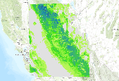
This dataset is a Basin Characterization Model (BCM) output using the PCM A2 Scenario for average Winter (December, January, February) snowpack, 2040-2069, clipped to the DRECP 12 km buffered boundary. Snowpack: Amount of snow accumulated per month summed annually, or if divided by 12 average monthly snowpack. This is calculated as prior month's snowpack plus snowfall minus sublimation and snow melt. The California Basin Characterization Model (BCM) climate dataset provides historical and projected climate surfaces for the state at a 270 meter resolution. The historical data is based on 4 kilometer PRISM data, and the projected climate surfaces are based on the A2 and B1 scenarios of the PCM and GFDL GCMs. The...
This dataset is a Basin Characterization Model (BCM) output using the PCM A2 Scenario for average Winter (December, January, February) snowpack, 2010-2039, clipped to the DRECP 12 km buffered boundary. Snowpack: Amount of snow accumulated per month summed annually, or if divided by 12 average monthly snowpack. This is calculated as prior month's snowpack plus snowfall minus sublimation and snow melt. The California Basin Characterization Model (BCM) climate dataset provides historical and projected climate surfaces for the state at a 270 meter resolution. The historical data is based on 4 kilometer PRISM data, and the projected climate surfaces are based on the A2 and B1 scenarios of the PCM and GFDL GCMs. The...

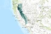
This dataset is a historic average Winter (December, January, February) snowpack, in southern Sierra Nevada California, for 1971-2000, from the California Basin Characterization Model (BCM) Snowpack: Amount of snow accumulated per month summed annually, or if divided by 12 average monthly snowpack. This is calculated as prior month's snowpack plus snowfall minus sublimation and snow melt. The California Basin Characterization Model (BCM) climate dataset provides historical and projected climate surfaces for the state at a 270 meter resolution. The historical data is based on 4 kilometer PRISM data, and the projected climate surfaces are based on the A2 and B1 scenarios of the PCM and GFDL GCMs. The BCM approach...

This dataset is a historic average Winter (December, January, February) snowpack, in northern Sierra Nevada California, for 1971-2000, from the California Basin Characterization Model (BCM) Snowpack: Amount of snow accumulated per month summed annually, or if divided by 12 average monthly snowpack. This is calculated as prior month's snowpack plus snowfall minus sublimation and snow melt. The California Basin Characterization Model (BCM) climate dataset provides historical and projected climate surfaces for the state at a 270 meter resolution. The historical data is based on 4 kilometer PRISM data, and the projected climate surfaces are based on the A2 and B1 scenarios of the PCM and GFDL GCMs. The BCM approach...

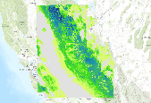
This dataset is a Basin Characterization Model (BCM) output using the GFDL A2 Scenario for average Spring (March, April, May) snowpack, in northern Sierra Nevada California, for 2040-2069, Snowpack: Amount of snow accumulated per month summed annually, or if divided by 12 average monthly snowpack. This is calculated as prior month's snowpack plus snowfall minus sublimation and snow melt. The California Basin Characterization Model (BCM) climate dataset provides historical and projected climate surfaces for the state at a 270 meter resolution. The historical data is based on 4 kilometer PRISM data, and the projected climate surfaces are based on the A2 and B1 scenarios of the PCM and GFDL GCMs. The BCM approach...
|

|
