Filters: Tags: soil (X) > partyWithName: U.S. Geological Survey (X)
24 results (29ms)|
Filters
Date Range
Extensions Types Contacts
Categories Tag Types Tag Schemes |
This data set presents attributes of floodplain ecosystem characteristics including floodplain soil denitrification, floodplain soil biogeochemistry, floodplain vegetation, floodplain sedimentation, floodplain and channel morphometry, stream discharge and water quality, floodplain climate, floodplain physiographic region, and catchment land cover. Attributes are associated with 18 floodplains of the Chesapeake Bay watershed. For many of these attributes, mean values are summaries of multiple measurements made within each floodplain site.
Categories: Data;
Tags: Maryland,
Pennsylvania,
USGS Science Data Catalog (SDC),
Virginia,
West Virginia,

These data were released prior to the October 1, 2016 effective date for the USGS’s policy dictating the review, approval, and release of scientific data as referenced in USGS Survey Manual Chapter 502.8 Fundamental Science Practices: Review and Approval of Scientific Data for Release. The digital data set delineates the outer boundary of each major discharge area evaluated as part of the study. These areas were used to refine estimates of ground-water discharge throughout the Death Valley regional flow system. As delineated, boundaries include all phreatophytic vegetation and moist soil areas within a discharge area. The boundaries were used to focus efforts associated with classifying the different vegetation...

These data were released prior to the October 1, 2016 effective date for the USGS’s policy dictating the review, approval, and release of scientific data as referenced in USGS Survey Manual Chapter 502.8 Fundamental Science Practices: Review and Approval of Scientific Data for Release. This spatial data set was created by the U.S. Geological Survey (USGS) to represent the area of soils with different levels of phosphorus retention potential in the Pacific Northwest region of the United States (Hydro Region 17; Major River Basin 7 (MRB7)) within each incremental watershed delineated in the NHDPlus v2 dataset.
These data were released prior to the October 1, 2016 effective date for the USGS’s policy dictating the review, approval, and release of scientific data as referenced in USGS Survey Manual Chapter 502.8 Fundamental Science Practices: Review and Approval of Scientific Data for Release. The digital data set provides locations and general descriptions of sites instrumented to collect micrometeorological data from which mean annual ET rates were computed. Sites are located in Ash Meadows and Oasis Valley, Nevada. Data were collected December 1993 through present.

These data were released prior to the October 1, 2016 effective date for the USGS’s policy dictating the review, approval, and release of scientific data as referenced in USGS Survey Manual Chapter 502.8 Fundamental Science Practices: Review and Approval of Scientific Data for Release. This spatial data set was created by the U.S. Geological Survey (USGS) to represent the extent of soils with very high levels of phosphorus retention potential in the Pacific Northwest region of the United States (Hydro Region 17; Major River Basin 7 (MRB7)).
This data release includes geochemical, x-ray diffraction mineralogical, and electron probe microanalysis (EPMA) data on rocks, soils, and sediments collected near the Orange Hill and Bond Creek porphyry copper deposits, Nabesna quadrangle, Alaska. Geochemical analyses were completed by a laboratory under contract with the U.S. Geological Survey (USGS). Electron microprobe and x-ray diffraction mineralogical analyses were completed by personnel of the Central Region Minerals Program in Denver, Colorado. The samples were collected and analyzed during 2014 to 2016, selected to help characterize the distribution and composition of mineralized and unmineralized geologic materials in this remote part of the eastern Alaska...
Categories: Data;
Types: Citation,
Downloadable,
Map Service,
OGC WFS Layer,
OGC WMS Layer,
Shapefile;
Tags: Alaska,
Alaska Range,
Alder Gulch,
Bond Creek,
Chathenda Creek,
The Weldona 7.5' quadrangle is located on the semiarid plains of northeastern Colorado, along the South Platte River corridor where the river has incised into Upper Cretaceous Pierre Shale. The Pierre Shale is largely covered by surficial deposits that formed from alluvial, eolian, and hillslope processes operating in concert with environmental changes from the Pleistocene to the present. The South Platte River, originating high in the Colorado Rocky Mountains, has played a major role in shaping surficial geology in the map area, which is several tens of kilometers downstream from where headwater tributaries join the river. Recurrent glaciation (and deglaciation) of basin headwaters has affected river discharge...
We identified nine study site locations, representing three mature vegetation communities [Atlantic White Cedar (desired community), tall pine pocosin (desired community), and red maple/black gum mixed (undesired community)] with typical water depth within each vegetation type. All measurements were replicated three times (3 vegetation types x 3 replicates = 9 sites total). We installed four flux chambers at each site to collect GHG fluxes from all nine sites. We measured CO2 and CH4 using a Los Gatos Research Ultra Portable Greenhouse Gas Analyzer and two-part 760 cm2 flux chambers (chamber base remained in situ; chamber top was placed on the bottom only when sampling). We checked the gas fluxes on a monthly time-table...
Categories: Data;
Types: Map Service,
OGC WFS Layer,
OGC WMS Layer,
OGC WMS Service;
Tags: Ecology,
Geochemistry,
Great Dismal Swamp National Wildlife Refuge,
Land Use Change,
Soil Sciences,
The Fort Morgan 7.5' quadrangle is located on the semiarid plains of northeastern Colorado, along the South Platte River corridor where the river has incised into Upper Cretaceous Pierre Shale. The Pierre Shale is largely covered by surficial deposits that formed from alluvial, eolian, and hillslope processes operating in concert with environmental changes from the late Pliocene to the present. The South Platte River, originating high in the Colorado Rocky Mountains, has played a major role in shaping surficial geology in the map area, which is several tens of kilometers downstream from where headwater tributaries join the river. Recurrent glaciation (and deglaciation) of basin headwaters has affected river discharge...

These data were released prior to the October 1, 2016 effective date for the USGS’s policy dictating the review, approval, and release of scientific data as referenced in USGS Survey Manual Chapter 502.8 Fundamental Science Practices: Review and Approval of Scientific Data for Release. This spatial data set was created by the U.S. Geological Survey (USGS) to represent the extent of soils with moderate phosphorus retention potential in the Pacific Northwest region of the United States (Hydro Region 17; Major River Basin 7 (MRB7))
Photographs used to verify ET units classified in the major discharge areas of Death Valley regional
These data were released prior to the October 1, 2016 effective date for the USGS’s policy dictating the review, approval, and release of scientific data as referenced in USGS Survey Manual Chapter 502.8 Fundamental Science Practices: Review and Approval of Scientific Data for Release. The digital data set provides point locations and general descriptions of areas photographed to document sites visited during a study to refine current estimates of ground-water discharge from the major discharge areas of the Death Valley regional flow system. Photographs were taken 1994-99. Sites were used as controls to better improve the delineation of ET (evapotranspiration) units classified using spectral methods throughout...
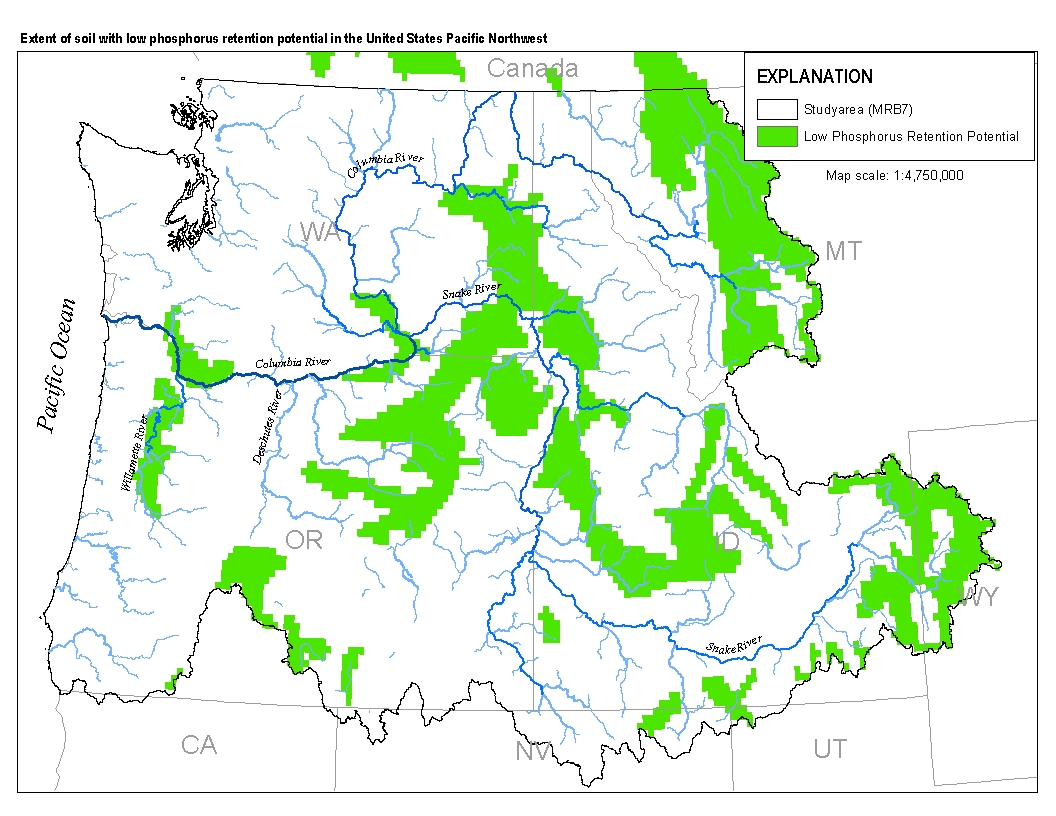
This spatial data set was created by the U.S. Geological Survey (USGS) to represent the extent of soils with low phosphorus retention potential in the Pacific Northwest region of the United States (Hydro Region 17; Major River Basin 7 (MRB7)).
Soil gas methane and combustible gas concentrations collected from oil and gas well pad locations in Utah. Soil gas samples were measured on site and/or collected for later analysis as described in supporting documentation. Multiple sample locations around well head and depths within the soil profile are available for select sites. Supporting documents provide information of sample collection protocol and data quality assurance.
Categories: Data;
Types: Map Service,
OGC WFS Layer,
OGC WMS Layer,
OGC WMS Service;
Tags: Big Flat,
Big Indian North,
Big Indian South,
Big Valley,
Bluebell,

These data were released prior to the October 1, 2016 effective date for the USGS’s policy dictating the review, approval, and release of scientific data as referenced in USGS Survey Manual Chapter 502.8 Fundamental Science Practices: Review and Approval of Scientific Data for Release. This spatial data set was created by the U.S. Geological Survey (USGS) to represent the extent of soils with low phosphorus retention potential in the Pacific Northwest region of the United States (Hydro Region 17; Major River Basin 7 (MRB7)).
We are provoding a set of table and maps that provides summary of ecosystem carbon balance (pools and fluxes) as simulated by the Dynamic Organic Soil version of the Terrestrial Ecosystem Model. Simulations are provided for the historical period from 1950 to 2009 and projections from 2010 to 2099, for the four main landscape conservation cooperative regions in Alaska (i.e. the Arctic, the Western Alaska, the North Pacific and the Northwest Boreal LCCs). Projections have been conducted at 1km-resolution for two set of climate scenarios for the A1B, B1 and A2 emission scenarios of the Intergovernmental Panel on Climate Change Special Report on Emissions Scenarios (IPCC-SRES). The two global circulation models used...
Categories: Data;
Types: Map Service,
OGC WFS Layer,
OGC WMS Layer,
OGC WMS Service;
Tags: Alaska,
Carbon balanace,
NCCWSC,
Soil,
Terrestrial ecosystem,
This data set includes metal concentrations measured in a species of earthworm (Eisenoides lonnbergi) collected at various locations on the Patuxent Wildlife Research Center.
Categories: Data;
Types: Citation,
Map Service,
OGC WFS Layer,
OGC WMS Layer,
OGC WMS Service;
Tags: Einsenoides lonnbergi,
Maryland,
Patuxent Wildlife Research Center,
USGS Science Data Catalog (SDC),
accumulation of lead,
Soil depth in the western United States obtained from the STATSGO Soils Database.
Categories: Data;
Types: Downloadable,
GeoTIFF,
Map Service,
Raster;
Tags: Arizona,
California,
Colorado,
Idaho,
Montana,

These data were released prior to the October 1, 2016 effective date for the USGS’s policy dictating the review, approval, and release of scientific data as referenced in USGS Survey Manual Chapter 502.8 Fundamental Science Practices: Review and Approval of Scientific Data for Release. This point feature class contains 81,481 points arranged in a 270-meter spaced grid that covers the Spring Mountains and Sheep Range in Clark County, Nevada. Points are attributed with hydroclimate variables and ancillary data compiled to support efforts to characterize ecological zones.

These data were released prior to the October 1, 2016 effective date for the USGS’s policy dictating the review, approval, and release of scientific data as referenced in USGS Survey Manual Chapter 502.8 Fundamental Science Practices: Review and Approval of Scientific Data for Release. This spatial data set was created by the U.S. Geological Survey (USGS) to represent the extent of soils with high phosphorus retention potential in the Pacific Northwest region of the United States (Hydro Region 17; Major River Basin 7 (MRB7)).
This dataset consists of a 100 meter resolution raster of depth and area weighted averages for soil pH for each map unit key (MUKEY) in the State Soil Geographical (STATSGO2) database (NRCS, 2016). This raster was developed from selected criteria of soil parameters from the STATSGO2 database and mapped to a 100 meter resolution rasterized version of MUKEY polygons.
|

|
