Filters: Tags: solar resource (X)
19 results (82ms)|
Filters
Date Range
Extensions Types Contacts
Categories Tag Types Tag Schemes |
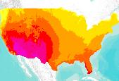
Monthly and annual average solar resource potential for 48 Contiguous United States.
The Great Plains Landscape Conservation Cooperative (GPLCC, https://www.fws.gov/science/catalog) is a partnership that provides applied science and decision support tools to assist natural resource managers conserve plants, fish and wildlife in the mid- and short-grass prairie of the southern Great Plains. It is part of a national network of public-private partnerships — known as Landscape Conservation Cooperatives (LCCs, http://www.fws.gov/science/shc/lcc.html) — that work collaboratively across jurisdictions and political boundaries to leverage resources and share science capacity. The Great Plains LCC identifies science priorities for the region and helps foster science that addresses these priorities to support...
Categories: Data;
Types: Downloadable,
Map Service,
OGC WFS Layer,
OGC WMS Layer,
Shapefile;
Tags: Direct Normal,
GPLCC,
Great Plains Landscape Conservation Cooperative,
Resource Potential,
Solar Resource

Monthly and annual average solar resource potential for 48 Contiguous United States.
The Great Plains Landscape Conservation Cooperative (GPLCC, https://www.fws.gov/science/catalog) is a partnership that provides applied science and decision support tools to assist natural resource managers conserve plants, fish and wildlife in the mid- and short-grass prairie of the southern Great Plains. It is part of a national network of public-private partnerships — known as Landscape Conservation Cooperatives (LCCs, http://www.fws.gov/science/shc/lcc.html) — that work collaboratively across jurisdictions and political boundaries to leverage resources and share science capacity. The Great Plains LCC identifies science priorities for the region and helps foster science that addresses these priorities to support...
Categories: Data;
Types: Downloadable,
Map Service,
OGC WFS Layer,
OGC WMS Layer,
Shapefile;
Tags: Direct Normal,
GPLCC,
Great Plains Landscape Conservation Cooperative,
Solar Resource,
filtered

This dataset highlights the areas showing the highest solar insolation in the West Mojave region. The dataset is comprised of on-the-ground data collected by field experts, which was a critical factor in the CEERT July 2012 proposal.  Satellite-only data identified the West Mojave to have the highest insolation levels, therefore the on-the-ground data was solicited to provide greater information about the area. On-the-ground data provides greater reliability and represents realistic opportunities for solar developments, and often diverges from the more easily accessibly satellite data of the same region. Because of the limited access to the proprietary data comprising on-the-ground data, most data available...
Tags: resource potential,
solar resource
Monthly and annual average solar resource potential for 48 Contiguous United States.
Monthly and annual average solar resource potential for 48 Contiguous United States.
This data provides monthly average and annual average daily total solar resource averaged over surface cells of 0.1 degrees in both latitude and longitude, or about 10 km in size, filtered to slopes less than 1%. This data was developed using the State University of New York/Albany satellite radiation model. This model was developed by Dr. Richard Perez and collaborators at the National Renewable Energy Laboratory and other universities for the U.S. Department of Energy. Specific information about this model can be found in Perez, et al. (2002). This model uses hourly radiance images from geostationary weather satellites, daily snow cover data, and monthly averages of atmospheric water vapor, trace gases, and the...
Monthly and annual average solar resource potential for 48 Contiguous United States.
Monthly and annual average solar resource potential for Wyoming. This dataset has been clipped and reprojected by WyGISC from the original National Dataset. For the Original data, visit the NREL website and download the data directly.
Categories: Data;
Types: Downloadable;
Tags: Contiguous United States,
Resource Potential,
Solar Resource,
climatologyMeteorologyAtmosphere
This data provides monthly average and annual average daily total solar resource averaged over surface cells of 0.1 degrees in both latitude and longitude, or about 10 km in size, filtered to slopes less than 1%. This data was developed using the State University of New York/Albany satellite radiation model. This model was developed by Dr. Richard Perez and collaborators at the National Renewable Energy Laboratory and other universities for the U.S. Department of Energy. Specific information about this model can be found in Perez, et al. (2002). This model uses hourly radiance images from geostationary weather satellites, daily snow cover data, and monthly averages of atmospheric water vapor, trace gases, and the...
The Great Plains Landscape Conservation Cooperative (GPLCC, https://www.fws.gov/science/catalog) is a partnership that provides applied science and decision support tools to assist natural resource managers conserve plants, fish and wildlife in the mid- and short-grass prairie of the southern Great Plains. It is part of a national network of public-private partnerships — known as Landscape Conservation Cooperatives (LCCs, http://www.fws.gov/science/shc/lcc.html) — that work collaboratively across jurisdictions and political boundaries to leverage resources and share science capacity. The Great Plains LCC identifies science priorities for the region and helps foster science that addresses these priorities to support...
Categories: Data;
Types: Downloadable,
Map Service,
OGC WFS Layer,
OGC WMS Layer,
Shapefile;
Tags: Direct Normal,
GPLCC,
Great Plains Landscape Conservation Cooperative,
Solar Resource,
filtered
Monthly and annual average solar resource potential forWyoming. This dataset has been clipped and reprojected by WyGISC from the original National Dataset. For the Original data, visit the NREL website and download the data directly.
Categories: Data;
Types: Downloadable;
Tags: Contiguous United States,
Resource Potential,
Solar Resource,
climatologyMeteorologyAtmosphere
The Great Plains Landscape Conservation Cooperative (GPLCC, https://www.fws.gov/science/catalog) is a partnership that provides applied science and decision support tools to assist natural resource managers conserve plants, fish and wildlife in the mid- and short-grass prairie of the southern Great Plains. It is part of a national network of public-private partnerships — known as Landscape Conservation Cooperatives (LCCs, http://www.fws.gov/science/shc/lcc.html) — that work collaboratively across jurisdictions and political boundaries to leverage resources and share science capacity. The Great Plains LCC identifies science priorities for the region and helps foster science that addresses these priorities to support...
Categories: Data;
Types: Downloadable,
Map Service,
OGC WFS Layer,
OGC WMS Layer,
Shapefile;
Tags: Direct Normal,
GPLCC,
Great Plains Landscape Conservation Cooperative,
Solar Resource,
filtered
Monthly and annual average solar resource potential for 48 Contiguous United States.
The Great Plains Landscape Conservation Cooperative (GPLCC, https://www.fws.gov/science/catalog) is a partnership that provides applied science and decision support tools to assist natural resource managers conserve plants, fish and wildlife in the mid- and short-grass prairie of the southern Great Plains. It is part of a national network of public-private partnerships — known as Landscape Conservation Cooperatives (LCCs, http://www.fws.gov/science/shc/lcc.html) — that work collaboratively across jurisdictions and political boundaries to leverage resources and share science capacity. The Great Plains LCC identifies science priorities for the region and helps foster science that addresses these priorities to support...
Categories: Data;
Types: Downloadable,
Map Service,
OGC WFS Layer,
OGC WMS Layer,
Shapefile;
Tags: GPLCC,
Great Plains Landscape Conservation Cooperative,
PV,
Resource Potential,
Solar Resource
The Great Plains Landscape Conservation Cooperative (GPLCC, https://www.fws.gov/science/catalog) is a partnership that provides applied science and decision support tools to assist natural resource managers conserve plants, fish and wildlife in the mid- and short-grass prairie of the southern Great Plains. It is part of a national network of public-private partnerships — known as Landscape Conservation Cooperatives (LCCs, http://www.fws.gov/science/shc/lcc.html) — that work collaboratively across jurisdictions and political boundaries to leverage resources and share science capacity. The Great Plains LCC identifies science priorities for the region and helps foster science that addresses these priorities to support...
Categories: Data;
Types: Downloadable,
Map Service,
OGC WFS Layer,
OGC WMS Layer,
Shapefile;
Tags: Direct Normal,
GPLCC,
Great Plains Landscape Conservation Cooperative,
Solar Resource,
filtered
The Great Plains Landscape Conservation Cooperative (GPLCC, https://www.fws.gov/science/catalog) is a partnership that provides applied science and decision support tools to assist natural resource managers conserve plants, fish and wildlife in the mid- and short-grass prairie of the southern Great Plains. It is part of a national network of public-private partnerships — known as Landscape Conservation Cooperatives (LCCs, http://www.fws.gov/science/shc/lcc.html) — that work collaboratively across jurisdictions and political boundaries to leverage resources and share science capacity. The Great Plains LCC identifies science priorities for the region and helps foster science that addresses these priorities to support...
Categories: Data;
Types: Downloadable,
Map Service,
OGC WFS Layer,
OGC WMS Layer,
Shapefile;
Tags: GPLCC,
Great Plains Landscape Conservation Cooperative,
Resource Potential,
Solar Resource
|

|
