Filters: Tags: south crest (X)
14 results (17ms)|
Filters
Date Range
Contacts Tag Schemes |

Study patches = permanent, long-term photopoint locations that represent Nolina interrata (NOIN) clusters within a NOIN index plot. Data collection within an index plot occurs at each study patch/photopoint location.

Boundaries of the Crestridge Ecological Reserve and South Crest Properties.
Tags: crestridge,
south crest

Location of 5 m2 paired plots used to monitor Brachypodium control efforts on the South Crest Property, San Diego County, CA. Monitoring was conducted as part of the SANDAG Environmental Mitigation Program (EMP)-funded Brachypodium control project.

Boundaries of Endangered Habitat Conservancy (EHC) 2012 acquisitions in the vicinity of South Crest (Michelson and City of El Cajon properties).
·Boundary of the South Crest Properties with parcel boundaries. Parcels in the County of San Diego.

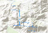
GPS locations of the corners of three (3) index plots established on South Crest for long-term monitoring of Nolina interrata (NOIN). Index plots were placed subjectively within NOIN patches identified in 2011. Plot dimensions are 50 m x 100 m (5000 m2) and plots are permanent.

Boundaries represent the spatial limits of the index plots.

High priority surveillance locations for invasive plant species on the Crestridge Ecological Reserve and South Crest properties, as discussed in the Early Detection Plan (CBI 2012).

Habitat assessment polygons and attribute data for the South Crest Property. Data were collected by CBI in support of a SANDAG Environmental Mitigation Program (EMP) grant for Brachypodium distachyon control on the Crestridge Ecological Reserve and South Crest Properties, San Diego County, CA.

Habitat assessment polygons and attribute data for the Crestridge Ecological Reserve and South Crest Property. Data were collected by CBI in support of a SANDAG Environmental Mitigation Program (EMP) grant for Brachypodium distachyon control on the Crestridge Ecological Reserve and South Crest Properties, San Diego County, CA.

EHC Conserved Lands, Crestridge and South Crest

Boundaries of the Crestridge Ecological Reserve and South Crest Properties.
Tags: crestridge,
south crest
|

|


