Filters: Tags: spring (X) > Types: Citation (X)
18 results (8ms)|
Filters
Date Range
Extensions Types Contacts
Categories Tag Types
|
Detrended, modelled first leaf dates for 856 sites across North America for the period 1900–2008 are used to examine how the El Niño Southern Oscillation (ENSO) and the Pacific Decadal Oscillation (PDO) separately and together might influence the timing of spring. Although spring (mean March through April) ENSO and PDO signals are apparent in first leaf dates, the signals are not statistically significant (at a 95% confidence level (p < 0.05)) for most sites. The most significant ENSO/PDO signal in first leaf dates occurs for El Niño and positive PDO conditions. An analysis of the spatial distributions of first leaf dates for separate and combined ENSO/PDO conditions features a northwest–southeast dipole that is...

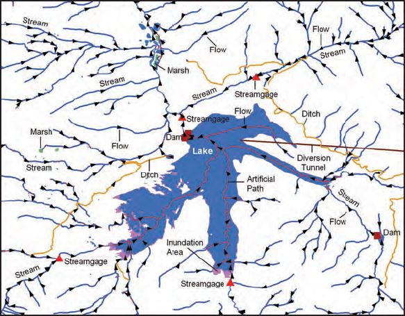
The USGS National Hydrography Dataset (NHD) service from The National Map (TNM) is a comprehensive set of digital spatial data that encodes information about naturally occurring and constructed bodies of surface water (lakes, ponds, and reservoirs), paths through which water flows (canals, ditches, streams, and rivers), and related entities such as point features (springs, wells, stream gages, and dams). The information encoded about these features includes classification and other characteristics, delineation, geographic name, position and related measures, a "reach code" through which other information can be related to the NHD, and the direction of water flow. The network of reach codes delineating water and...
This data set contains imagery from the National Agriculture Imagery Program (NAIP). The NAIP program is administered by USDA FSA and has been established to support two main FSA strategic goals centered on agricultural production. These are, increase stewardship of America's natural resources while enhancing the environment, and to ensure commodities are procured and distributed effectively and efficiently to increase food security. The NAIP program supports these goals by acquiring and providing ortho imagery that has been collected during the agricultural growing season in the U.S. The NAIP ortho imagery is tailored to meet FSA requirements and is a fundamental tool used to support FSA farm and conservation programs....
This data set contains imagery from the National Agriculture Imagery Program (NAIP). The NAIP program is administered by USDA FSA and has been established to support two main FSA strategic goals centered on agricultural production. These are increase stewardship of America's natural resources while enhancing the environment, and to ensure commodities are procured and distributed effectively and efficiently to increase food security. The NAIP program supports these goals by acquiring and providing ortho imagery that has been collected during the agricultural growing season in the U.S. The NAIP ortho imagery is tailored to meet FSA requirements and is a fundamental tool used to support FSA farm and conservation programs....
This data set contains imagery from the National Agriculture Imagery Program (NAIP). The NAIP program is administered by USDA FSA and has been established to support two main FSA strategic goals centered on agricultural production. These are increase stewardship of America's natural resources while enhancing the environment, and to ensure commodities are procured and distributed effectively and efficiently to increase food security. The NAIP program supports these goals by acquiring and providing ortho imagery that has been collected during the agricultural growing season in the U.S. The NAIP ortho imagery is tailored to meet FSA requirements and is a fundamental tool used to support FSA farm and conservation programs....
Detrended, modelled first leaf dates for 856 sites across North America for the period 1900–2008 are used to examine how the El Niño Southern Oscillation (ENSO) and the Pacific Decadal Oscillation (PDO) separately and together might influence the timing of spring. Although spring (mean March through April) ENSO and PDO signals are apparent in first leaf dates, the signals are not statistically significant (at a 95% confidence level (p < 0.05)) for most sites. The most significant ENSO/PDO signal in first leaf dates occurs for El Niño and positive PDO conditions. An analysis of the spatial distributions of first leaf dates for separate and combined ENSO/PDO conditions features a northwest–southeast dipole that is...
Sky Island Alliance (SIA) is a non-governmental organizational that works to protect and restore the rich natural heritage of native species and habitats in the Sky Island Region. We work with volunteers, scientists, land-owners, public officials, and government agencies to establish protected areas, restore healthy landscapes, and promote public appreciation of the region’s unique biological diversity. Because of our long-standing collaborative relationships with land managers and our large corps of skilled volunteers, we were in a unique position to spearhead this project.SIA initiated this springs inventory, assessment and management planning project to develop baseline information on springs in the Sky Island...
Categories: Data,
Publication;
Types: ArcGIS REST Map Service,
Citation,
Map Service,
OGC WFS Layer,
OGC WMS Layer,
OGC WMS Service;
Tags: 2011,
AZ-02,
AZ-03,
Arizona,
Conservation NGOs,
NatureServe worked with several federal, state, and NGO partners in the United States and Mexico to conduct a climate change vulnerability assessment of major natural community types found within the Mojave and Sonoran Deserts. The project focused on ten major upland, riparian, and aquatic community types, including pinyon-juniper woodlands, Joshua tree-blackbrush scrub, creosote-bursage scrub, salt desert scrub, Paloverde-mixed cacti scrub, semi-desert grassland, desert riparian and stream, riparian mesquite bosque, and desert springs. This effort piloted a new Habitat Climate Change Vulnerability Index (HCCVI) approach being developed by NatureServe, as a companion to an existing index for species. The project...
Categories: Publication;
Types: Citation,
Map Service,
OGC WFS Layer,
OGC WMS Layer,
OGC WMS Service;
Tags: Arizona,
BMP,
Baja California,
California,
English,
This data set contains imagery from the National Agriculture Imagery Program (NAIP). The NAIP program is administered by USDA FSA and has been established to support two main FSA strategic goals centered on agricultural production. These are increase stewardship of America's natural resources while enhancing the environment, and to ensure commodities are procured and distributed effectively and efficiently to increase food security. The NAIP program supports these goals by acquiring and providing ortho imagery that has been collected during the agricultural growing season in the U.S. The NAIP ortho imagery is tailored to meet FSA requirements and is a fundamental tool used to support FSA farm and conservation programs....
This data set contains imagery from the National Agriculture Imagery Program (NAIP). The NAIP program is administered by USDA FSA and has been established to support two main FSA strategic goals centered on agricultural production. These are increase stewardship of America's natural resources while enhancing the environment, and to ensure commodities are procured and distributed effectively and efficiently to increase food security. The NAIP program supports these goals by acquiring and providing ortho imagery that has been collected during the agricultural growing season in the U.S. The NAIP ortho imagery is tailored to meet FSA requirements and is a fundamental tool used to support FSA farm and conservation programs....
This data set contains imagery from the National Agriculture Imagery Program (NAIP). The NAIP program is administered by USDA FSA and has been established to support two main FSA strategic goals centered on agricultural production. These are, increase stewardship of America's natural resources while enhancing the environment, and to ensure commodities are procured and distributed effectively and efficiently to increase food security. The NAIP program supports these goals by acquiring and providing ortho imagery that has been collected during the agricultural growing season in the U.S. The NAIP ortho imagery is tailored to meet FSA requirements and is a fundamental tool used to support FSA farm and conservation programs....
This report is volume 2 of a two-volume ecological assessment of grassland ecosystems in the Southwestern United States. Broad-scale assessments are syntheses of current scientific knowledge, including a description of uncertainties and assumptions, to provide a characterization and comprehensive description of ecological, social, and economic components within an assessment area. Volume 1 of this assessment focused on the ecology, types, conditions, and management practices of Southwestern grasslands. Volume 2 (this volume) describes wildlife and fish species, their habitat requirements, and species-specific management concerns, in Southwestern grasslands. This assessment is regional in scale and pertains primarily...
Categories: Publication;
Types: Citation,
Map Service,
OGC WFS Layer,
OGC WMS Layer,
OGC WMS Service;
Tags: BMP,
Chihuahuan Desert,
English,
Sonoran Desert,
agriculture,
Most groundwater conservation and management efforts focus on protecting groundwater for drinking water and for other human uses with little understanding or focus on the ecosystems that depend on groundwater. However, groundwater plays an integral role in sustaining certain types of aquatic, terrestrial and coastal ecosystems, and their associated landscapes. Our aim was to illuminate the connection between groundwater and surface ecosystems by identifying and mapping the distribution of groundwater dependent ecosystems (GDEs) in California. This layer includes watersheds from the Watershed Boundary Database at the 12-digit hydrologic unit code (HUC12) scale. Each watershed is attributed with summary information...
Categories: Publication;
Types: Citation,
Map Service,
OGC WFS Layer,
OGC WMS Layer,
OGC WMS Service;
Tags: GIS,
groundwater,
map,
spring,
stream,
This data set contains imagery from the National Agriculture Imagery Program (NAIP). The NAIP program is administered by USDA FSA and has been established to support two main FSA strategic goals centered on agricultural production. These are, increase stewardship of America's natural resources while enhancing the environment, and to ensure commodities are procured and distributed effectively and efficiently to increase food security. The NAIP program supports these goals by acquiring and providing ortho imagery that has been collected during the agricultural growing season in the U.S. The NAIP ortho imagery is tailored to meet FSA requirements and is a fundamental tool used to support FSA farm and conservation programs....
This data set contains imagery from the National Agriculture Imagery Program (NAIP). The NAIP program is administered by USDA FSA and has been established to support two main FSA strategic goals centered on agricultural production. These are, increase stewardship of America's natural resources while enhancing the environment, and to ensure commodities are procured and distributed effectively and efficiently to increase food security. The NAIP program supports these goals by acquiring and providing ortho imagery that has been collected during the agricultural growing season in the U.S. The NAIP ortho imagery is tailored to meet FSA requirements and is a fundamental tool used to support FSA farm and conservation programs....
U.S. Geological Survey, Department of the Interior - The annual National Hydrography Dataset (NHD) stewardship plan is to maintain hydrography data in the NHD over the United States and its territories. NHD for the nation has been collected and is now in maintenance mode. Interested parties who wish to become a NHD stewardship partner with the USGS in FY17 or in future years should contact a USGS Geospatial Liaison - http://liaisons.usgs.gov/geospatial/documents/TNM_Partnership_User_ContactList.pdf. To find out more about hydrography stewardship go to http://nhd.usgs.gov/stewardship.html or for exact project status information on areas currently in work go to http://nhd.usgs.gov/project_status.html
Types: Citation;
Tags: Hydrography,
NGDA,
NHD,
National Geospatial Data Asset,
National Hydrography Dataset,
The rapidly increasing demands being placed on our deserts points to the urgent need for a connectivity assessment that spans multiple jurisdictional boundaries and promotes the partnerships needed to implement a regional conservation strategy for this diverse and striking landscape. The vast scale of renewable energy developments proposed in the California deserts are likely to impact habitat connectivity, alter essential ecosystem functions, and eliminate opportunities for species to shift their ranges in response to climate change. The potential impacts of energy development on our existing public lands, specifically to wildlife and their ability to move across the landscape, are enormous. The primary goal of...
Categories: Publication;
Types: Citation,
Map Service,
OGC WFS Layer,
OGC WMS Layer,
OGC WMS Service;
Tags: BMP,
California,
GIS,
OHV,
assessment,
Categories: Publication;
Types: Citation,
Map Service,
OGC WFS Layer,
OGC WMS Layer,
OGC WMS Service;
Tags: amphibian,
fish,
invasive,
inventory,
invertebrate,
|

|
