Filters: Tags: tehachapi (X) > partyWithName: Conservation Biology Institute (X)
35 results (121ms)|
Filters
Date Range
Tag Schemes |
The Nature Conservancy (TNC) has derived climate suitability forecasts for most species of trees and shrubs considered to be ecological dominants of terrestrial Californian habitat types. Our plant projections are compiled as decision support tools to help Conservancy project staff, as well as our external partners, develop the necessary plans, priorities and strategies to successfully adapt to uncertain changes in future climate. In the recently completed Southern Sierra Partnership's 2010 Climate-Adapted Conservation Plan for the Southern Sierra Nevada and Tehachapi Mountains, species and habitat forecasts shown here informed the development of a regional conservation design that explicitly incorporates long-term...

The objective of this project was to digitally map the boundaries of Audubon California's Important Bird Areas (IBA). Existing Important Bird Areas identify critical terrestrial and inland water habitats for avifauna, in particular, habitat that supports rare, threatened or endangered birds and/or exceptionally large congregations of shorebirds and/or waterfowl. The digitization of Important Bird Areas represents an important first step in conservation planning of these critical habitats using GIS. As of October 2007, a draft layer of all 148 Important Bird Areas in California was completed. Currently, a review is in progress with Audubon Chapters and local experts, with a final version completed by Nov. 1, 2008....
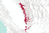
Description: This is the scenario summed solution from the low goals run. This is one of the four scenarios that were combined to form the basis of the regional conservation design. Regional Conservation Design generated by the Southern Sierra Partnership as part of the report ("Framework"): “ Framework for Cooperative Conservation and Climate Adaptation for the Southern Sierra Nevada and Tehachapi Mountains”. See Framework (Section 5.2, Table 7) for low and high goals for vegetation systems, rare plant substrate, etc.

The Nature Conservancy (TNC) has derived climate suitability forecasts for most species of trees and shrubs considered to be ecological dominants of terrestrial Californian habitat types. Our plant projections are compiled as decision support tools to help Conservancy project staff, as well as our external partners, develop the necessary plans, priorities and strategies to successfully adapt to uncertain changes in future climate. In the recently completed Southern Sierra Partnership's 2010 Climate-Adapted Conservation Plan for the Southern Sierra Nevada and Tehachapi Mountains, species and habitat forecasts shown here informed the development of a regional conservation design that explicitly incorporates long-term...

This dataset is an extraction of ACECs in the Tehachapi region from PAD-US 1.1 (CBI Edition), by state, which was then reviewed by the CA BLM Field Offices for accuracy.

Compilation of USFS-CDF Calveg vegetation type mapping and Land Cover Mapping and Monitoring program Multi-source land cover layer. The Calveg data was given precedence when the two layers were merged; the multi-source data was used to fill in a few araes where Calveg was not completed. The Calveg data were downloaded in 2007 and may not be the most recent for some tiles.

This is the table used to represent the suitability or cost layer to be used in Marxan. Suitability is comprised of three weighted threats: Roads were weighted 2x, intensive agriculture 1x and housing density 5x. The local road & highway weighting was done before being combined with agriculture and housing density.

Viewshed calculated in ArcMap for the Pacific Crest Trail within the Tehachapi study area (and buffer) using a viewing radius of 50 km. This dataset indicates areas that can be seen by hikers on the PCT.

This is the scenario summed solution from the high goals run. This is one of the four scenarios that were combined to form the basis of the regional conservation design. Regional Conservation Design generated by the Southern Sierra Partnership as part of the report ("Framework"): “ Framework for Cooperative Conservation and Climate Adaptation for the Southern Sierra Nevada and Tehachapi Mountains”. See Framework (Section 5.2, Table 7) for low and high goals set for vegetation systems, rare plant substrate, etc.

Roadless areas by Ownership in the Tehachapi study area, with Percentage or acreage for each Roadless Area calculated

BLM, Bakersfield, Resource Management Plan 2013

This dataset is an extraction from PAD-US 1.1 of BLM ACECs in the Tehachapi study area that are designated species habitat. This dataset is an extraction from PAD-US 1.1 (CBI Edition), by state.The PAD-US 1.1 (CBI Edition) data set portrays the nation's protectedareas with a standardized spatial geometry and numerous valuableattributes on land ownership, management designations, and conservationstatus (using national GAP and international IUCN coding systems). ThePAD-US 1.1 (CBI Edition) defines protected areas to include all landsdedicated to the preservation of biological diversity and to othernatural, recreation and cultural uses, and managed for these purposesthrough legal or other effective means (adapted from...

We used a tool created by the above authors to develop a vector ruggedness measure (VRM) of terrain in our study area based on a geomorphological method for measuring vector dispersion that is less correlated with slope. This measure of ruggedness incorporates variability in both the aspect and gradient component of slope and provides a more biologically meaningful way to measure terrain ruggedness.
Tags: ruggedness,
tehachapi

Roadless areas categorized by the level of impact of dirt roads and structures not captured in the roadless analysis. Impact was categorized by placing each area into one of the following categories: 1) Heavy - some/many roads or trails, or roads or trails distributed over a majority of the polygon 2) Moderate - some/few roads or trails in some portions of the polygon 3) Low - no roads or trails, or few roads or trails that are restricted to a minor proportion of the polygon

Roadless areas greater than 5000 acres in the Tehcahpi study area, checked against NPAI aerial photography

California Central Valley Mixed Oak Savanna and CA Coastal Live Oak Woodland and Savanna from USGS Gap, and Valley Oak Woodland from CALVEG.
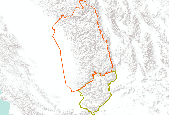
Planning area boundaries for Southern Sierra and Tehachapi Conservation Action Plans (project-level CAPs). Abridged versions of the two CAPs are presented in the Framework’s Appendix.

U.S. and Canada Detailed Streets represents streets, highways, roads with and without limited access, secondary and connecting roads, local and rural roads, roads with special characteristics, access ramps, and ferries within the United States and Canada. This data set contains road network features such as arterial classification, speed, and direction of travel. It contains address ranges for all addressable features with addresses.

The Nature Conservancy (TNC) has derived climate suitability forecasts for most species of trees and shrubs considered to be ecological dominants of terrestrial Californian habitat types. Our plant projections are compiled as decision support tools to help Conservancy project staff, as well as our external partners, develop the necessary plans, priorities and strategies to successfully adapt to uncertain changes in future climate. In the recently completed Southern Sierra Partnership's 2010 Climate-Adapted Conservation Plan for the Southern Sierra Nevada and Tehachapi Mountains, species and habitat forecasts shown here informed the development of a regional conservation design that explicitly incorporates long-term...

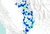
This is the scenario summed solution from the high goals run that included climate adaptation factors. This is one of the four scenarios that were combined to form the basis of the regional conservation design. Regional Conservation Design generated by the Southern Sierra Partnership as part of the report ("Framework"): “Framework for Cooperative Conservation and Climate Adaptation for the Southern Sierra Nevada and Tehachapi Mountains”. See section 5.0 of Framework for goals and methods.
|

|
