Filters: Tags: threatened species (X)
39 results (34ms)|
Filters
|
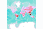
Number of globally threatened animals, by terrestrial ecoregion. We compiled a vertebrate species list for each ecoregion from WWF’s WildFinder database (WWF 2006). This list was then compared against the IUCN Red List of Threatened Species (2008) to determine the number of species per ecoregion that are threatened. Threatened species are those listed by IUCN Red List as Vulnerable, Endangered, or Critically Endangered (www.redlist.org). These data were derived by The Nature Conservancy, and were displayed in a map published in The Atlas of Global Conservation (Hoekstra et al., University of California Press, 2010). More information at http://nature.org/atlas. Data derived from: World Wildlife Fund (WWF). 2006....
These data are estimates of den emergence date, den site departure dates, and duration at den sites as well as post-emergence observations for female polar bears sampled in the southern Beaufort Sea subpopulation 1985-2016 and the Chukchi Sea subpopulation 2008-2017. The data were used to better understand the importance of time spent at the den site post-emergence. Emergence dates and departure dates were determined using collar temperature sensor data.
This dataset includes measures collected on polar bears captured in the Chukchi and Beaufort Seas, 1981-2017 by the U.S. Geological Survey and U.S. Fish and Wildlife Service. Data collected include body length, body mass, axillary girth, skull width and tail lengths. Bears were also aged as described in the methods. For some bears, an adipose tissue sample was collected and percent lipid content was measured, percent body fat was measured via bioelectrical impedance analysis, and/or recent feeding behavior was assessed via gut palpitation or blood urea and creatinine levels, all of which are further described in the methods.
Potential habitat for the American burying beetle (Nicrophorus americanus) in eastern Oklahoma was derived from a published habitat suitability index for their Southern Plains range.
Potential habitat for the piping plover (Charadrius melodus) in Oklahoma was derived from the published Gap Analysis Project (GAP) Species Habitat Map.
The Long Term Resource Monitoring (LTRM) annual fish monitoring began on the Upper Mississippi and Illinois Rivers in 1989. During the first two years samples were collected at a series of fixed sampling sites, then in 1993 a stratified random sampling approach was added to the collection effort. This approach utilizes a computer routine that randomly selects sampling sites from a pool of potential sites that have been categorized by strata (e.g., aquatic habitat type, distance to shore, connectivity to main channel). The results from these collections are stored in an Oracle database at the Upper Midwest Environmental Science Center (UMESC). UMESC provides free access to the data through the Centers Web site (www.umesc.usgs.gov)....
Types: Map Service,
OGC WFS Layer,
OGC WMS Layer,
OGC WMS Service;
Tags: Fish,
Fishery,
Illinois,
Illinois River,
Iowa,
Climate change vulnerability assessments are commonly used to identify species or populations at risk from global climate change, but few translate impact assessments to climate change adaptation actions. Furthermore, most climate change adaptation efforts emphasize where to implement management actions, whereas timing remains largely overlooked. The rate of modern climate change introduces urgency in evaluating whether delaying conservation actions compromises their efficacy for reaching important conservation targets. We evaluated the importance of multiple climate change adaptation strategies including timing of actions on preventing extinctions for a threatened climate-sensitive species, the Eastern Massasauga...
Critical habitat lines - Mississippi River BasinWhen a species is proposed for listing as endangered or threatened under the Endangered Species Act, the U.S. Fish and Wildlife Service must consider whether there are areas of habitat believed to be essential the species’ conservation. Those areas may be proposed for designation as “critical habitat.” Critical habitat is a term defined and used in the Act. It is a specific geographic area(s) that contains features essential for the conservation of a threatened or endangered species and that may require special management and protection. Critical habitat may include an area that is not currently occupied by the species but that will be needed for its recovery. An area...
Categories: Data;
Types: Citation,
Downloadable,
Map Service,
OGC WFS Layer,
OGC WMS Layer,
Shapefile;
Tags: Biota,
Critical Habitat,
Endangered species,
Listed species,
Threatened species,
When a species is proposed for listing as endangered or threatened under the Endangered Species Act, the U.S. Fish and Wildlife Service must consider whether there are areas of habitat believed to be essential the species’ conservation. Those areas may be proposed for designation as “critical habitat.” Critical habitat is a term defined and used in the Act. It is a specific geographic area(s) that contains features essential for the conservation of a threatened or endangered species and that may require special management and protection. Critical habitat may include an area that is not currently occupied by the species but that will be needed for its recovery. An area is designated as “critical habitat” after the...
Categories: Data;
Types: ArcGIS REST Map Service,
ArcGIS Service Definition,
Citation,
Downloadable,
Map Service;
Tags: Alabama,
Alaska,
Arizona,
Arkansas,
Biota,
Abstract (from http://www.nature.com/nclimate/journal/vaop/ncurrent/full/nclimate2252.html): Climate change will decrease worldwide biodiversity through a number of potential pathways1, including invasive hybridization2 (cross-breeding between invasive and native species). How climate warming influences the spread of hybridization and loss of native genomes poses difficult ecological and evolutionary questions with little empirical information to guide conservation management decisions3. Here we combine long-term genetic monitoring data with high-resolution climate and stream temperature predictions to evaluate how recent climate warming has influenced the spatio-temporal spread of human-mediated hybridization between...
Categories: Publication;
Types: Citation;
Tags: Fish,
Northwest CASC,
Rivers, Streams and Lakes,
Water, Coasts and Ice,
Wildlife and Plants,
These data are estimates of den emergence date, den site departure dates, and duration at den sites as well as post-emergence observations for female polar bears sampled in the southern Beaufort Sea subpopulation 1985-2016 and the Chukchi Sea subpopulation 2008-2017. The data were used to better understand the importance of time spent at the den site post-emergence. Emergence dates and departure dates were determined using collar temperature sensor data.
When a species is proposed for listing as endangered or threatened under the Endangered Species Act, the U.S. Fish and Wildlife Service must consider whether there are areas of habitat believed to be essential the species’ conservation. Those areas may be proposed for designation as “critical habitat.” Critical habitat is a term defined and used in the Act. It is a specific geographic area(s) that contains features essential for the conservation of a threatened or endangered species and that may require special management and protection. Critical habitat may include an area that is not currently occupied by the species but that will be needed for its recovery. An area is designated as “critical habitat” after the...
Categories: Data;
Types: ArcGIS REST Map Service,
ArcGIS Service Definition,
Citation,
Downloadable,
Map Service;
Tags: Alabama,
Alaska,
Arizona,
Arkansas,
Biota,
We analyzed variation in canopy closure around 47 Mexican spotted owl (Strix occidentalis lucida) nest sires and 47 random forest sites on the Coconino National Forest in northcentral Arizona. We mapped distinct habitat polygons on 1:15,840 color aerial photographs, assigned each polygon to one of 4 canopy-closure classes (70%), and measured the area in each canopy class within 5 concentric analysis zones with radii of 0.1, 0.4, 0.8, 1.2, and 1.6 km (delineating rings of about 4, 47, 150, 252, and 352 ha). Landscape composition differed between spotted owl nest and random sites (P 70% canopy-closure class and less area in the 70% canopy predominated Nesting spotted owls selected areas with denser canopy than randomly...
Categories: Publication;
Types: Citation,
Journal Citation;
Tags: Arizona,
Journal of Wildlife Management,
Mexican spotted owl,
Strix occidentalis lucida,
aerial photography,
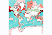
Number of globally threatened marine mammal species, by marine ecoregion. Using the online IUCN resource, the threatened species for each ecoregion were filtered for marine species only. Threatened species refer to those listed by IUCN Red List as Vulnerable, Endangered, or Critically Endangered (www.redlist.org). We downloaded the digital GIS data and summarized it by marine ecoregion to result in the number of threatened species per marine ecoregion. These data were derived by The Nature Conservancy, and were displayed in a map published in The Atlas of Global Conservation (Hoekstra et al., University of California Press, 2010). More information at http://nature.org/atlas. Data derived from: International Union...
Small-bodied, riverine minnows that historically characterized fish assemblages of Great Plains rivers in North America have declined because of river fragmentation, dewatering, river channel degradation, river salinization and nonnative species introductions. The Pecos bluntnose shiner Notropis simus pecosensis, a member of this guild, persists in one segment of the Pecos River, New Mexico, USA. We characterized habitat associations for the species at two spatial scales. In general, N. s. pecosensis associated with fluvial habitats, but velocity association depended on body size, with larger individuals using swifter habitats. All N. s. pecosensis associated with relatively low depths (3–51 cm), which were most...
Categories: Publication;
Types: Citation,
Journal Citation;
Tags: Pecos River,
River Research and Applications,
aquatic habitat,
flow management,
river fragmentation,
U.S. Geological Survey and partners are testing the effects of prescribed fire on Black Rails, Yellow Rails, and Mottled Ducks in the high marsh habitats of the northern Gulf of Mexico region. The study is conducted in cooperation with Mississippi State University, Illinois Natural History Survey, U.S. Fish and Wildlife Service, state agencies, universities, and non-governmental organizations. The objectives of this project are to develop an adaptive management framework that allows land managers to reduce our uncertainty about the effects of prescribed fire on these species and the habitats on which they depend, and give managers tools and information that will help them determine the best management actions to...
THIS IS A HISTORICAL RECORD. As of December 17, 2021, the BISON application will no longer be available online and has been replaced by https://www.gbif.us. The BISON APIs are still available at https://bison.usgs.gov/#api and the Integrated Publishing Toolkit is still available at https://bison.usgs.gov/ipt. The USGS Biodiversity Information Serving Our Nation (BISON) project is an online all-species mapping information system consisting of a large collection of species occurrence datasets (e.g., plants and animals) found in the United States, U.S. Territories, U.S. marine Exclusive Economic Zones (EEZ), and Canada, with relevant geospatial layers. Species occurrences are records of organisms at a particular...
We developed an expert opinion questionnaire to gather information regarding expert opinion regarding the importance of climate variables in determining a species geographic range (Brandt et al. 2017). The data on the Survey_Results tab represent the raw survey questions and responses. Each column in the spreadsheet (except the first four columns, described below) represents a survey question, which is written in the first cell of that column. Each survey response for that question is listed below. Some questions have multi-part answers, and are listed in multiple columns, and appended with letters (e.g., Q8A, Q8B, Q8C, etc.). The first four columns of the spreadhseet represent unique information for that survey...
Categories: Data;
Types: Citation;
Tags: Florida,
climate adaptation,
climate change,
conservation,
conservation planning,
Potential habitat for the Ozark big-eared bat (Corynorhinus townsendii ingens) in Oklahoma was derived from the published Gap Analysis Project (GAP) Species Habitat Map.
This comprehensive database describes the core attributes of quantification tools developed for market-based conservation in the United States. It encompasses tools designed for compensatory mitigation, non-compensatory mitigation, and voluntary conservation/restoration programs. The dataset consists of 107 tools. Each tool's features are described using 33 attributes related to general, technical, and ecological/geographic details. This database was first published in 2018. Version 2.0 expands upon the original database by including tools developed for compensatory mitigation under the Clean Water Act section 404 regulatory program. Version 2.0 also provides updates on tool details provided in the original database....
Categories: Data,
Data Release - Revised;
Tags: Aquatic resource,
Assessment methodology,
At-risk species,
Biodiversity,
Biodiversity market,
|

|
