Filters: Tags: urban growth (X)
20 results (33ms)|
Filters
Date Range
Extensions Types
Contacts
Categories Tag Types
|
These data represent the extent of urbanization (for the year indicated) predicted by the model SLEUTH, developed by Dr. Keith C. Clarke, at the University of California, Santa Barbara, Department of Geography and modified by David I. Donato of the United States Geological Survey (USGS) Eastern Geographic Science Center (EGSC). Further model modification and implementation was performed at the Biodiversity and Spatial Information Center at North Carolina State University
Categories: Data;
Tags: Birds,
Data Layers,
ESRI,
SERAP,
South Atlantic Landscape Conservation Cooperative,
GIS layers showing current and future connectivity for pine snake, eastern diamondback rattlesnake, eastern couger, red wolf, and black bear
Categories: Data;
Tags: Climate change,
Completed,
Data,
Data.gov South Atlantic Landscape Conservation Cooperative,
Datasets/Database,
Policy-relevant flood risk modeling must capture interactions between physical and social processes to accurately project impacts from scenarios of sea level rise and inland flooding due to climate change. Here we simultaneously model urban growth, flood hazard change, and adaptive response using the FUTure Urban-Regional Environment Simulation (FUTURES) version 3 framework (Sanchez et al., 2023). FUTURES is an open source urban growth model designed to address the regional-scale ecological and environmental impacts of urbanization; it is one of the few land change models that explicitly captures the spatial structure of development in response to user-specified scenarios. We present probabilistic land change projections...
This report summarizes the results of a three-year investigation of terrestrial habitat connectivity priorities for the South Atlantic Landscape Conservation Cooperative (South Atlantic LCC). Our primary objective was to generate results that could be used to drive fine‐scaled conservation planning to enhance habitat connectivity across the South Atlantic LCC. The project focused on seven target species, including large mammals (black bear, red wolf, Florida panther/eastern cougar) and a group of terrestrial reptiles (eastern diamondback rattlesnake, timber rattlesnake, pine snake, and box turtle). We used two different modeling approaches to identify areas with either high predicted flow of a given species (Circuitscape)...
This digital map shows the areal extent of surficial deposits and rock stratigraphic units (formations) as compiled by Trimble and Machette from 1973 to 1977 and published in 1979 under the Front Range Urban Corridor Geology Program. Trimble and Machette compiled their geologic map from published geologic maps and unpublished geologic mapping having varied map unit schemes. A convenient feature of the compiled map is its uniform classification of geologic units that mostly matches those of companion maps to the north (USGS I-855-G) and to the south (USGS I-857-F). Published as a color paper map, the Trimble and Machette map was intended for land-use planning in the Front Range Urban Corridor. This map recently (1997-1999)...

This raster dataset is the result of a subtraction of the classification of raster datasets bhd2030us and bhd2000us. Both are produced using the SERGoM v3 model, they depict housing density for the coterminous US in 2030 and 2000, resp., and are based on 2000 US Census Bureau block (SF1) datasets. (The classication of the subtraction is shown below.) A raster layer that portrays not-developed (and assumed to be undevelopable) called CUS_UPP_100 depicts protected/unprotected lands and Census water polygons. First, Land was removed from blocks (reducing the area of a block, but not its number of housing units -- assuming that private housing units must be on private land) that was public and/or protected in the UNPROTPRIV100...
Tags: drecp,
urban growth
Managing ecosystems for resilience and sustainability requires understanding how they will respond to future anthropogenic drivers such as climate change and urbanization. In fire-dependent ecosystems, predicting this response requires a focus on how these drivers will impact fire regimes. Here, we use scenarios of climate change, urbanization and management to simulate the future dynamics of the critically endangered and fire-dependent longleaf pine (Pinus palustris) ecosystem. We investigated how climate change and urbanization will affect the ecosystem, and whether the two conservation goals of a 135% increase in total longleaf area and a doubling of fire-maintained open-canopy habitat can be achieved in the...
Categories: Publication;
Types: Citation;
Tags: Climate-resilient,
Conservation,
Landscapes,
Open-canopy longleaf,
Other Landscapes,
We simulated future patterns of urban growth using the FUTure Urban-Regional Environment Simulation (FUTURES; Meentemeyer et al., 2013) version 2 framework. FUTURES is an open source urban growth model designed to address the regional-scale ecological and environmental impacts of urbanization; it is one of the few land change models that explicitly captures the spatial structure of development in response to user-specified scenarios. We present probabilistic land change projections that predict urban growth under a Status Quo scenarios of growth. We computed each scenario for 50 stochastic iterations from 2020 through 2100 at annual time steps.
Probability of Development, Northeast U.S. is one of a suite of products from the Nature’s Network project (naturesnetwork.org). Nature’s Network is a collaborative effort to identify shared priorities for conservation in the Northeast, considering the value of fish and wildlife species and the natural areas they inhabit. This index represents the integrated probability of development occurring sometime between 2010 and 2030 at the 30 m cell level. It was based on models of historical patterns of urban growth in the Northeast, including the type (low intensity, medium intensity and high intensity), amount and spatial pattern of development, and incorporates the influence of factors such as geophysical conditions...
Categories: Data;
Types: ArcGIS REST Map Service,
ArcGIS Service Definition,
Citation,
Downloadable,
Map Service;
Tags: 2030,
2030,
Data,
LCC Network Science Catalog,
North Atlantic Landscape Conservation Cooperative Data.gov,
This digital map shows the geographic extent of rock stratigraphic units (formations) as compiled by Colton in 1976 under the Front Range Urban Corridor Geology Program. Colton used his own geologic mapping and previously published geologic maps to compile one map having a single classification of geologic units. The resulting published color paper map (USGS Map I-855-G, Colton, 1978) was intended for land-use planning and to depict the regional geology. In 1997-1999, another USGS project designed to address urban growth issues was undertaken. This project, the USGS Front Range Infrastructure Resources Project, undertook to digitize Colton's map at 1:100,000 scale, making it useable in Geographical Information Systems...

These data represent the extent of urbanization (for the year indicated) predicted by the model SLEUTH, developed by Dr. Keith C. Clarke, at the University of California, Santa Barbara, Department of Geography and modified by David I. Donato of the United States Geological Survey (USGS) Eastern Geographic Science Center (EGSC). Further model modification and implementation was performed at the Biodiversity and Spatial Information Center at North Carolina State University. More information about these data (along with downloadable ESRI GRID files) can be found at http://www.basic.ncsu.edu/dsl/urb.html
Probability of Development, Northeast U.S. is one of a suite of products from the Nature’s Network project (naturesnetwork.org). Nature’s Network is a collaborative effort to identify shared priorities for conservation in the Northeast, considering the value of fish and wildlife species and the natural areas they inhabit. This index represents the integrated probability of development occurring sometime between 2010 and 2080 at the 30 m cell level. It was based on models of historical patterns of urban growth in the Northeast, including the type (low intensity, medium intensity and high intensity), amount and spatial pattern of development, and incorporates the influence of factors such as geophysical conditions...
Categories: Data;
Types: ArcGIS REST Map Service,
ArcGIS Service Definition,
Citation,
Downloadable,
Map Service;
Tags: 2080,
2080,
Data,
LCC Network Science Catalog,
North Atlantic Landscape Conservation Cooperative Data.gov,
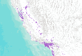
20 year Projected Urban Growth scenarios. Base year is 2000. Projected year in this dataset is 2020. Acquired from Cal-Atlas at http://www.atlas.ca.gov/download.html#/casil/society .

These data represent the extent of urbanization (for the year indicated) predicted by the model SLEUTH, developed by Dr. Keith C. Clarke, at the University of California, Santa Barbara, Department of Geography and modified by David I. Donato of the United States Geological Survey (USGS) Eastern Geographic Science Center (EGSC). Further model modification and implementation was performed at the Biodiversity and Spatial Information Center at North Carolina State University. More information about these data (along with downloadable ESRI GRID files) can be found at http://www.basic.ncsu.edu/dsl/urb.html

50 year Projected Urban Growth scenarios. Base year is 2000. Projected year in this dataset is 2020. Acquired from Cal-Atlas at http://www.atlas.ca.gov/download.html#/casil/society.
The purpose of this community is to provide a public access point to data sets published by the EGSC.
By 2020, most forecasters agree, California will be home to between 43 and 46 million residents-up from 35 million today. Beyond 2020 the size of California's population is less certain. Depending on the composition of the population, and future fertility and migration rates, California's 2050 population could be as little as 50 million or as much as 70 million. One hundred years from now, if present trends continue, California could conceivably have as many as 90 million residents. Where these future residents will live and work is unclear. For most of the 20th Century, two-thirds of Californians have lived south of the Tehachapi Mountains and west of the San Jacinto Mountains-in that part of the state commonly...

These data represent the extent of urbanization (for the year indicated) predicted by the model SLEUTH, developed by Dr. Keith C. Clarke, at the University of California, Santa Barbara, Department of Geography and modified by David I. Donato of the United States Geological Survey (USGS) Eastern Geographic Science Center (EGSC). Further model modification and implementation was performed at the Biodiversity and Spatial Information Center at North Carolina State University. More information about these data (along with downloadable ESRI GRID files) can be found at http://www.basic.ncsu.edu/dsl/urb.html
By 2020, most forecasters agree, California will be home to between 43 and 46 million residents-up from 35 million today. Beyond 2020 the size of California's population is less certain. Depending on the composition of the population, and future fertility and migration rates, California's 2050 population could be as little as 50 million or as much as 70 million. One hundred years from now, if present trends continue, California could conceivably have as many as 90 million residents. Where these future residents will live and work is unclear. For most of the 20th Century, two-thirds of Californians have lived south of the Tehachapi Mountains and west of the San Jacinto Mountains-in that part of the state commonly...
These data represent the extent of urbanization (for the year indicated) predicted by the model SLEUTH, developed by Dr. Keith C. Clarke, at the University of California, Santa Barbara, Department of Geography and modified by David I. Donato of the United States Geological Survey (USGS) Eastern Geographic Science Center (EGSC). Further model modification and implementation was performed at the Biodiversity and Spatial Information Center at North Carolina State University.
Categories: Data;
Types: ArcGIS Map Package,
ArcGIS REST Map Service,
ArcGIS Service Definition,
Downloadable,
Map Service;
Tags: SERAP,
Southeast Regional Assessment Project,
urban growth
|

|
