Filters: Tags: vegetation departure (X)
32 results (111ms)|
Filters
Date Range
Types Contacts
Tag Types Tag Schemes
|
Vegetation Departure (VDEP) data product ranges from 0 - 100 to depict the amount current vegetation has departed from simulated historical vegetation reference conditions. This departure results from changes to species composition, structural stage, and canopy closure. VDEP is calculated based on changes to species composition, structural stage, and canopy closure using methods described in the Interagency Fire Regime Condition Class Guidebook. LANDFIRE VDEP is based on departure of current vegetation conditions from reference vegetation conditions only, whereas the Guidebook approach includes departure of current fire regimes from those of the reference period. LANDFIRE simulates historical vegetation reference...
This map shows the classes, vegetation departure, current/future landscape intactness, current/future change agents, and potential for change for the Visual Resource Management (VRM) in the study area. These data are provided by Bureau of Land Management (BLM) "as is" and may contain errors or omissions. The User assumes the entire risk associated with its use of these data and bears all responsibility in determining whether these data are fit for the User's intended use. These data may not have the accuracy, resolution, completeness, timeliness, or other characteristics appropriate for applications that potential users of the data may contemplate. The User is encouraged to carefully consider the content of the...
This map shows the distribution, vegetation departure, current/future landscape intactness, current/future change agents, and potential for change of Northern Goshawk Habitat in the study area. These data are provided by Bureau of Land Management (BLM) "as is" and may contain errors or omissions. The User assumes the entire risk associated with its use of these data and bears all responsibility in determining whether these data are fit for the User's intended use. These data may not have the accuracy, resolution, completeness, timeliness, or other characteristics appropriate for applications that potential users of the data may contemplate. The User is encouraged to carefully consider the content of the metadata...
This specific Utah dataset displays vegatation departure between current vegetation conditions and reference vegetation conditions) index represented using a 0 to 100 percent scale, with 100 representing maximum departure.The Utah dataset was reclassified so additional layer values representing Water (111), Snow / Ice (112), Urban (120), Barren (131), Sparsely Vegetated BpS (132), and Agriculture (180) are NO LONGER INCLUDED in this dataset. Please see general Landfire description below for more detailed information on the VDEP product.Broad-scale alterations of historical fire regimes and vegetation dynamics have occurred in many landscapes in the U.S. through the combined influence of land management practices,...
This map shows the distribution, vegetation departure, current/future landscape intactness, current/future change agents, and potential for change of Ferruginous Hawk Habitat in the study area. These data are provided by Bureau of Land Management (BLM) "as is" and may contain errors or omissions. The User assumes the entire risk associated with its use of these data and bears all responsibility in determining whether these data are fit for the User's intended use. These data may not have the accuracy, resolution, completeness, timeliness, or other characteristics appropriate for applications that potential users of the data may contemplate. The User is encouraged to carefully consider the content of the metadata...
This map shows the distribution, vegetation departure, current/future landscape intactness, current/future change agents, and potential for change of Grassland Fauna Habitat in the study area. These data are provided by Bureau of Land Management (BLM) "as is" and may contain errors or omissions. The User assumes the entire risk associated with its use of these data and bears all responsibility in determining whether these data are fit for the User's intended use. These data may not have the accuracy, resolution, completeness, timeliness, or other characteristics appropriate for applications that potential users of the data may contemplate. The User is encouraged to carefully consider the content of the metadata...
This map shows the distribution, vegetation departure, current/future landscape intactness, current/future change agents, and potential for change of Native Fish in the study area. These data are provided by Bureau of Land Management (BLM) "as is" and may contain errors or omissions. The User assumes the entire risk associated with its use of these data and bears all responsibility in determining whether these data are fit for the User's intended use. These data may not have the accuracy, resolution, completeness, timeliness, or other characteristics appropriate for applications that potential users of the data may contemplate. The User is encouraged to carefully consider the content of the metadata file associated...
This map shows the managed/un-managed sites of Ecological Value. This map also shows distribution, vegetation departure, current/future landscape intactness, current/future change agents, and potential for change of the Sites of Conservation Concern (SCC). These data are provided by Bureau of Land Management (BLM) "as is" and may contain errors or omissions. The User assumes the entire risk associated with its use of these data and bears all responsibility in determining whether these data are fit for the User's intended use. These data may not have the accuracy, resolution, completeness, timeliness, or other characteristics appropriate for applications that potential users of the data may contemplate. The User...
LANDFIRE’s (LF) 2022 Vegetation Departure (VDep) product categorizes departure between current vegetation condition and reference vegetation condition, according to the methods outlined in the Interagency Fire Regime Condition Class Guidebook (FRCC Guidebook (Hann et al 2010)). VDep differs from the FRCC Guidebook, however, because it is based on the departure of current vegetation condition only, whereas the FRCC Guidebook approach includes departure of current fire regimes for the reference period. For VDep, summary units are defined as a BioPhysical Setting (BpS) with identical reference condition values regardless of map zone. For example, when a BpS is present in map zone 1, 2, 4, 5, 6 and 8, the reference...
This map shows the distribution, vegetation departure, current/future landscape intactness, current/future change agents, and potential for change of Mountain Lion Habitat in the study area. These data are provided by Bureau of Land Management (BLM) "as is" and may contain errors or omissions. The User assumes the entire risk associated with its use of these data and bears all responsibility in determining whether these data are fit for the User's intended use. These data may not have the accuracy, resolution, completeness, timeliness, or other characteristics appropriate for applications that potential users of the data may contemplate. The User is encouraged to carefully consider the content of the metadata file...
This map shows the number of sensitve species, distribution, vegetation departure, current/future landscape intactness, current/future change agents, and potential for change of Biodiversity in the study area. These data are provided by Bureau of Land Management (BLM) "as is" and may contain errors or omissions. The User assumes the entire risk associated with its use of these data and bears all responsibility in determining whether these data are fit for the User's intended use. These data may not have the accuracy, resolution, completeness, timeliness, or other characteristics appropriate for applications that potential users of the data may contemplate. The User is encouraged to carefully consider the content...
This map shows the hydrologic features, vegetation departure, current/future landscape intactness, current/future change agents, potential for change, impaired waters, average snow depth, wells, aquifers, snow melt, discharge, and active groundwater level of Hydrological Systems in the study area. These data are provided by Bureau of Land Management (BLM) "as is" and may contain errors or omissions. The User assumes the entire risk associated with its use of these data and bears all responsibility in determining whether these data are fit for the User's intended use. These data may not have the accuracy, resolution, completeness, timeliness, or other characteristics appropriate for applications that potential users...
This map shows the distribution, vegetation departure, current/future landscape intactness, current/future change agents, and potential for change of Bighorn Sheep Habitat in the study area. These data are provided by Bureau of Land Management (BLM) "as is" and may contain errors or omissions. The User assumes the entire risk associated with its use of these data and bears all responsibility in determining whether these data are fit for the User's intended use. These data may not have the accuracy, resolution, completeness, timeliness, or other characteristics appropriate for applications that potential users of the data may contemplate. The User is encouraged to carefully consider the content of the metadata file...
This map shows the distribution, vegetation departure, current/future landscape intactness, current/future change agents, and potential for change of Gunnison Sage-Grouse Habitat in the study area. These data are provided by Bureau of Land Management (BLM) "as is" and may contain errors or omissions. The User assumes the entire risk associated with its use of these data and bears all responsibility in determining whether these data are fit for the User's intended use. These data may not have the accuracy, resolution, completeness, timeliness, or other characteristics appropriate for applications that potential users of the data may contemplate. The User is encouraged to carefully consider the content of the metadata...
This map shows the distribution, vegetation departure, current/future landscape intactness, current/future change agents, and potential for change of Mexican Free-Tailed Bat Habitat in the study area. These data are provided by Bureau of Land Management (BLM) "as is" and may contain errors or omissions. The User assumes the entire risk associated with its use of these data and bears all responsibility in determining whether these data are fit for the User's intended use. These data may not have the accuracy, resolution, completeness, timeliness, or other characteristics appropriate for applications that potential users of the data may contemplate. The User is encouraged to carefully consider the content of the metadata...
This map shows the distribution, vegetation departure, current/future landscape intactness, current/future change agents, and potential for change of Pronghorn Habitat in the study area. These data are provided by Bureau of Land Management (BLM) "as is" and may contain errors or omissions. The User assumes the entire risk associated with its use of these data and bears all responsibility in determining whether these data are fit for the User's intended use. These data may not have the accuracy, resolution, completeness, timeliness, or other characteristics appropriate for applications that potential users of the data may contemplate. The User is encouraged to carefully consider the content of the metadata file associated...
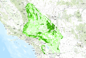
This map shows current vegetation departure in the study area. These data are provided by Bureau of Land Management (BLM) "as is" and may contain errors or omissions. The User assumes the entire risk associated with its use of these data and bears all responsibility in determining whether these data are fit for the User's intended use. These data may not have the accuracy, resolution, completeness, timeliness, or other characteristics appropriate for applications that potential users of the data may contemplate. The User is encouraged to carefully consider the content of the metadata file associated with these data. The BLM should be cited as the data source in any products derived from these data.
Broad-scale alterations of historical fire regimes and vegetation dynamics have occurred in many landscapes in the U.S. through the combined influence of land management practices, fire exclusion, ungulate herbivory, insect and disease outbreaks, climate change, and invasion of non-native plant species. The LANDFIRE Project produces maps of simulated historical fire regimes and vegetation conditions using the LANDSUM landscape succession and disturbance dynamics model. The LANDFIRE Project also produces maps of current vegetation and measurements of current vegetation departure from simulated historical reference conditions. These maps support fire and landscape management planning outlined in the goals of the National...
Broad-scale alterations of historical fire regimes and vegetation dynamics have occurred in many landscapes in the U.S. through the combined influence of land management practices, fire exclusion, ungulate herbivory, insect and disease outbreaks, climate change, and invasion of non-native plant species. The LANDFIRE Project produces maps of simulated historical fire regimes and vegetation conditions using the LANDSUM landscape succession and disturbance dynamics model. The LANDFIRE Project also produces maps of current vegetation and measurements of current vegetation departure from simulated historical reference conditions. These maps support fire and landscape management planning outlined in the goals of the National...
Vegetation Departure (VDEP) data product ranges from 0 - 100 to depict the amount current vegetation has departed from simulated historical vegetation reference conditions. This departure results from changes to species composition, structural stage, and canopy closure. VDEP is calculated based on changes to species composition, structural stage, and canopy closure using methods described in the Interagency Fire Regime Condition Class Guidebook. LANDFIRE VDEP is based on departure of current vegetation conditions from reference vegetation conditions only, whereas the Guidebook approach includes departure of current fire regimes from those of the reference period. LANDFIRE simulates historical vegetation reference...
|

|
