Filters: Tags: winter precipitation (X)
15 results (9ms)|
Filters
Date Range
Extensions Types
Contacts
Categories Tag Types Tag Schemes |
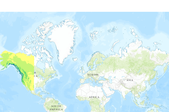
This set of 4 rasters shows winter (Dec to Feb) precipitation (mm) for Western North America under the B1 Emissions Scenario from the Intergovernmental Panel on Climate Change (IPCC). One layer shows the historic period (1961 to 1990), and there are three layers of future climate projections representing the 2020s, the 2050s, and the 2080s. These future layers are ensemble averages across all 23 CMIP3 AOGCMs (Coupled Model Intercomparison Project 3 Atmosphere-Ocean General Circulation Models). All layers have a resolution of 1 km, and are designed to capture climate gradients, temperature inversions, and rain shadows in the mountainous landscape of western North America. These data, originally published here, were...
Categories: Data;
Types: ArcGIS REST Map Service,
ArcGIS Service Definition,
Downloadable,
Map Service;
Tags: 2020s,
2050s,
2080s,
B1,
ClimateWNA,
Estimated precipitation data were compiled using the WestMap web site (http://www.cefa.dri.edu/Westmap/) from 1995-2013. We selected pixels on the map shown on their web site that were in the core of our study areas: one near Palm Springs, California and the other at Sugarloaf Mountain in the Tonto National Forest of Arizona. WestMap uses PRISM data to make point measurements of climate data and a digital elevation model of terrain to create estimates of monthly climate elements. Estimates are derived for a 4km grid, for ease in mapping and GIS applications. PRISM is an integrated set of rules, decision making, and calculations designed to imitate the process an expert climatologist would go through when mapping...
This set of 4 rasters shows winter (Dec to Feb) precipitation (mm) for Western North America under the A2 Emissions Scenario from the Intergovernmental Panel on Climate Change (IPCC). One layer shows the historic period (1961 to 1990), and there are three layers of future climate projections representing the 2020s, the 2050s, and the 2080s. These future layers are ensemble averages across all 23 CMIP3 AOGCMs (Coupled Model Intercomparison Project 3 Atmosphere-Ocean General Circulation Models). All layers have a resolution of 1 km, and are designed to capture climate gradients, temperature inversions, and rain shadows in the mountainous landscape of western North America. These data, originally published here, were...
Categories: Data;
Types: ArcGIS REST Map Service,
ArcGIS Service Definition,
Downloadable,
Map Service;
Tags: 2020s,
2050s,
2080s,
A2,
ClimateWNA,

This set of 4 rasters shows winter (Dec to Feb) precipitation (mm) for Western North America under the A1B Emissions Scenario from the Intergovernmental Panel on Climate Change (IPCC). One layer shows the historic period (1961 to 1990), and there are three layers of future climate projections representing the 2020s, the 2050s, and the 2080s. These future layers are ensemble averages across all 23 CMIP3 AOGCMs (Coupled Model Intercomparison Project 3 Atmosphere-Ocean General Circulation Models). All layers have a resolution of 1 km, and are designed to capture climate gradients, temperature inversions, and rain shadows in the mountainous landscape of western North America.
Winter precipitation was extracted from the PRISM 1980-2010 precipitation dataset for the months of November through March. The extent of the bull trout range was used to mask the analysis. Using Zonal Statistics the mean for the November - March timeframe was calculated. Binning the data into 10 classes, the lowest class was determined to be not at risk for winter flooding (based on Haak et al. 2010 methodology).
This set of 4 rasters shows winter (Dec to Feb) precipitation (mm) for Western North America under the B1 Emissions Scenario from the Intergovernmental Panel on Climate Change (IPCC). One layer shows the historic period (1961 to 1990), and there are three layers of future climate projections representing the 2020s, the 2050s, and the 2080s. These future layers are ensemble averages across all 23 CMIP3 AOGCMs (Coupled Model Intercomparison Project 3 Atmosphere-Ocean General Circulation Models). All layers have a resolution of 1 km, and are designed to capture climate gradients, temperature inversions, and rain shadows in the mountainous landscape of western North America.
This map contains winter precipitation (Nov - March) for use in determining winter flood risk for the coldwater fish range based on HUC12 analysis unit. These data are provided by Bureau of Land Management (BLM) "as is" and may contain errors or omissions. The User assumes the entire risk associated with its use of these data and bears all responsibility in determining whether these data are fit for the User's intended use. These data may not have the accuracy, resolution, completeness, timeliness, or other characteristics appropriate for applications that potential users of the data may contemplate. The User is encouraged to carefully consider the content of the metadata file associated with these data. The BLM...
North Slope Terrestrial Subregions Basemap, Projected mean January temperatures, Temperature projections for July, Projected annual, summer, winter precipitation (mm, rainwater equivalent). These data are provided by Bureau of Land Management (BLM) "as is" and may contain errors or omissions. The User assumes the entire risk associated with its use of these data and bears all responsibility in determining whether these data are fit for the User's intended use. These data may not have the accuracy, resolution, completeness, timeliness, or other characteristics appropriate for applications that potential users of the data may contemplate. The User is encouraged to carefully consider the content of the metadata file...

This set of 4 rasters shows winter (Dec to Feb) precipitation (mm) for Western North America under the A2 Emissions Scenario from the Intergovernmental Panel on Climate Change (IPCC). One layer shows the historic period (1961 to 1990), and there are three layers of future climate projections representing the 2020s, the 2050s, and the 2080s. These future layers are ensemble averages across all 23 CMIP3 AOGCMs (Coupled Model Intercomparison Project 3 Atmosphere-Ocean General Circulation Models). All layers have a resolution of 1 km, and are designed to capture climate gradients, temperature inversions, and rain shadows in the mountainous landscape of western North America.
Winter precipitation was extracted from the PRISM 1980-2010 precipitation dataset for the months of November through March. The extent of the coildwater fish range was used to mask the analysis. Using Zonal Statistics the mean for the November - March timeframe was calculated. Binning the data into 10 classes, the lowest class was determined to be not at risk for winter flooding (based on Haak et al. 2010 methodology).
This map contains winter precipitation (Nov - March) for use in determining winter flood risk for the coldwater fish range based on 4km analysis grid. These data are provided by Bureau of Land Management (BLM) "as is" and may contain errors or omissions. The User assumes the entire risk associated with its use of these data and bears all responsibility in determining whether these data are fit for the User's intended use. These data may not have the accuracy, resolution, completeness, timeliness, or other characteristics appropriate for applications that potential users of the data may contemplate. The User is encouraged to carefully consider the content of the metadata file associated with these data. The BLM should...
Winter precipitation was extracted from the PRISM 1980-2010 precipitation dataset for the months of November through March. The extent of the coildwater fish range was used to mask the analysis. Using Zonal Statistics the mean for the November - March timeframe was calculated. Binning the data into 10 classes, the lowest class was determined to be not at risk for winter flooding (based on Haak et al. 2010 methodology).
This set of 4 rasters shows winter (Dec to Feb) precipitation (mm) for Western North America under the A1B Emissions Scenario from the Intergovernmental Panel on Climate Change (IPCC). One layer shows the historic period (1961 to 1990), and there are three layers of future climate projections representing the 2020s, the 2050s, and the 2080s. These future layers are ensemble averages across all 23 CMIP3 AOGCMs (Coupled Model Intercomparison Project 3 Atmosphere-Ocean General Circulation Models). All layers have a resolution of 1 km, and are designed to capture climate gradients, temperature inversions, and rain shadows in the mountainous landscape of western North America. These data, originally published here,...
Categories: Data;
Types: ArcGIS REST Map Service,
ArcGIS Service Definition,
Downloadable,
Map Service;
Tags: 2020s,
2050s,
2080s,
A1B,
ClimateWNA,

This set of 4 rasters shows winter (Dec to Feb) precipitation (mm) for Western North America under the A1B Emissions Scenario from the Intergovernmental Panel on Climate Change (IPCC). One layer shows the historic period (1961 to 1990), and there are three layers of future climate projections representing the 2020s, the 2050s, and the 2080s. These future layers are ensemble averages across all 23 CMIP3 AOGCMs (Coupled Model Intercomparison Project 3 Atmosphere-Ocean General Circulation Models). All layers have a resolution of 1 km, and are designed to capture climate gradients, temperature inversions, and rain shadows in the mountainous landscape of western North America.
Winter precipitation was extracted from the PRISM 1980-2010 precipitation dataset for the months of November through March. The extent of the bull trout range was used to mask the analysis. Using Zonal Statistics the mean for the November - March timeframe was calculated. Binning the data into 10 classes, the lowest class was determined to be not at risk for winter flooding (based on Haak et al. 2010 methodology).
|

|
