Filters: partyWithName: Charles Cannon (X)
29 results (8ms)|
Filters
Date Range
Contacts (Less)
Categories (Less) Tag Types Tag Schemes |

These data were released prior to the October 1, 2016 effective date for the USGS’s policy dictating the review, approval, and release of scientific data as referenced in USGS Survey Manual Chapter 502.8 Fundamental Science Practices: Review and Approval of Scientific Data for Release. The Umpqua River drains 12,103 square kilometers (4,673 square miles) in southwest Oregon before flowing into the Pacific Ocean at Winchester Bay near the city of Reedsport. In cooperation with the Portland District of the U.S. Army Corps of Engineers (USACE), the USGS evaluated sediment transport and gravel storage along the downstream alluvial reaches of the North and South Umpqua Rivers and the entire mainstem Umpqua River. This...

These data were released prior to the October 1, 2016 effective date for the USGS’s policy dictating the review, approval, and release of scientific data as referenced in USGS Survey Manual Chapter 502.8 Fundamental Science Practices: Review and Approval of Scientific Data for Release. The Umpqua River drains 12,103 square kilometers (4,673 square miles) in southwest Oregon before flowing into the Pacific Ocean at Winchester Bay near the city of Reedsport. In cooperation with the Portland District of the U.S. Army Corps of Engineers (USACE), the USGS evaluated sediment transport and gravel storage along the downstream alluvial reaches of the North and South Umpqua Rivers and the entire mainstem Umpqua River. This...

These data were released prior to the October 1, 2016 effective date for the USGS’s policy dictating the review, approval, and release of scientific data as referenced in USGS Survey Manual Chapter 502.8 Fundamental Science Practices: Review and Approval of Scientific Data for Release. Estuarine ecosystems are controlled by a variety of processes that operate at multiple spatial and temporal scales. Understanding the hierarchical nature of these processes will aid in prioritization of restoration efforts. This hierarchical Columbia River Estuary Ecosystem Classification (henceforth "Classification") of the Columbia River estuary is a spatial database of the tidally-influenced reaches of the lower Columbia River,...

These data were released prior to the October 1, 2016 effective date for the USGS’s policy dictating the review, approval, and release of scientific data as referenced in USGS Survey Manual Chapter 502.8 Fundamental Science Practices: Review and Approval of Scientific Data for Release. The Umpqua River drains 12,103 square kilometers (4,673 square miles) in southwest Oregon before flowing into the Pacific Ocean at Winchester Bay near the city of Reedsport. In cooperation with the Portland District of the U.S. Army Corps of Engineers (USACE), the USGS evaluated sediment transport and gravel storage along the downstream alluvial reaches of the North and South Umpqua Rivers and the entire mainstem Umpqua River. This...

These data were released prior to the October 1, 2016 effective date for the USGS’s policy dictating the review, approval, and release of scientific data as referenced in USGS Survey Manual Chapter 502.8 Fundamental Science Practices: Review and Approval of Scientific Data for Release. The Umpqua River drains 12,103 square kilometers (4,673 square miles) in southwest Oregon before flowing into the Pacific Ocean at Winchester Bay near the city of Reedsport. In cooperation with the Portland District of the U.S. Army Corps of Engineers (USACE), the USGS evaluated sediment transport and gravel storage along the downstream alluvial reaches of the North and South Umpqua Rivers and the entire mainstem Umpqua River. This...

These data were released prior to the October 1, 2016 effective date for the USGS’s policy dictating the review, approval, and release of scientific data as referenced in USGS Survey Manual Chapter 502.8 Fundamental Science Practices: Review and Approval of Scientific Data for Release. The Umpqua River drains 12,103 square kilometers (4,673 square miles) in southwest Oregon before flowing into the Pacific Ocean at Winchester Bay near the city of Reedsport. In cooperation with the Portland District of the U.S. Army Corps of Engineers (USACE), the USGS evaluated sediment transport and gravel storage along the downstream alluvial reaches of the North and South Umpqua Rivers and the entire mainstem Umpqua River. This...

These data were released prior to the October 1, 2016 effective date for the USGS’s policy dictating the review, approval, and release of scientific data as referenced in USGS Survey Manual Chapter 502.8 Fundamental Science Practices: Review and Approval of Scientific Data for Release. The Umpqua River drains 12,103 square kilometers (4,673 square miles) in southwest Oregon before flowing into the Pacific Ocean at Winchester Bay near the city of Reedsport. In cooperation with the Portland District of the U.S. Army Corps of Engineers (USACE), the USGS evaluated sediment transport and gravel storage along the downstream alluvial reaches of the North and South Umpqua Rivers and the entire mainstem Umpqua River. This...

These data were released prior to the October 1, 2016 effective date for the USGS’s policy dictating the review, approval, and release of scientific data as referenced in USGS Survey Manual Chapter 502.8 Fundamental Science Practices: Review and Approval of Scientific Data for Release. The Umpqua River drains 12,103 square kilometers (4,673 square miles) in southwest Oregon before flowing into the Pacific Ocean at Winchester Bay near the city of Reedsport. In cooperation with the Portland District of the U.S. Army Corps of Engineers (USACE), the USGS evaluated sediment transport and gravel storage along the downstream alluvial reaches of the North and South Umpqua Rivers and the entire mainstem Umpqua River. This...

These data were released prior to the October 1, 2016 effective date for the USGS’s policy dictating the review, approval, and release of scientific data as referenced in USGS Survey Manual Chapter 502.8 Fundamental Science Practices: Review and Approval of Scientific Data for Release. Estuarine ecosystems are controlled by a variety of processes that operate at multiple spatial and temporal scales. Understanding the hierarchical nature of these processes will aid in prioritization of restoration efforts. This hierarchical Columbia River Estuary Ecosystem Classification (henceforth "Classification") of the Columbia River estuary is a spatial database of the tidally-influenced reaches of the lower Columbia River,...
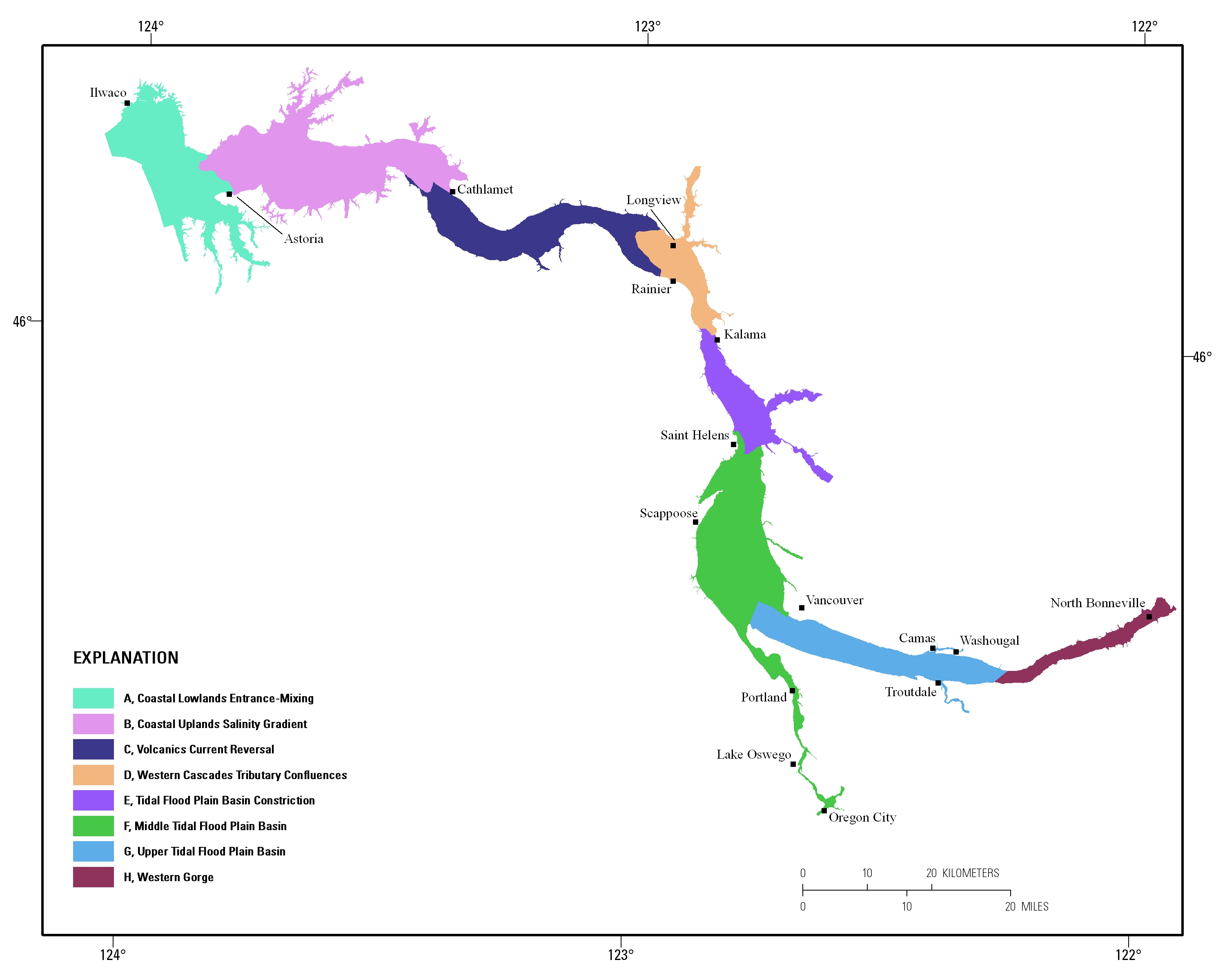
Estuarine ecosystems are controlled by a variety of processes that operate at multiple spatial and temporal scales. Understanding the hierarchical nature of these processes will aid in prioritization of restoration efforts. This hierarchical Columbia River Estuary Ecosystem Classification (henceforth "Classification") of the Columbia River estuary is a spatial database of the tidally-influenced reaches of the lower Columbia River, the tidally affected parts of its tributaries, and the landforms that make up their floodplains for the 230 kilometers between the Pacific Ocean and Bonneville Dam. This work is a collaborative effort between University of Washington School of Aquatic and Fishery Sciences (henceforth "UW"),...

These data were released prior to the October 1, 2016 effective date for the USGS’s policy dictating the review, approval, and release of scientific data as referenced in USGS Survey Manual Chapter 502.8 Fundamental Science Practices: Review and Approval of Scientific Data for Release. The Umpqua River drains 12,103 square kilometers (4,673 square miles) in southwest Oregon before flowing into the Pacific Ocean at Winchester Bay near the city of Reedsport. In cooperation with the Portland District of the U.S. Army Corps of Engineers (USACE), the USGS evaluated sediment transport and gravel storage along the downstream alluvial reaches of the North and South Umpqua Rivers and the entire mainstem Umpqua River. This...

These data were released prior to the October 1, 2016 effective date for the USGS’s policy dictating the review, approval, and release of scientific data as referenced in USGS Survey Manual Chapter 502.8 Fundamental Science Practices: Review and Approval of Scientific Data for Release. The Umpqua River drains 12,103 square kilometers (4,673 square miles) in southwest Oregon before flowing into the Pacific Ocean at Winchester Bay near the city of Reedsport. In cooperation with the Portland District of the U.S. Army Corps of Engineers (USACE), the USGS evaluated sediment transport and gravel storage along the downstream alluvial reaches of the North and South Umpqua Rivers and the entire mainstem Umpqua River. This...

These data were released prior to the October 1, 2016 effective date for the USGS’s policy dictating the review, approval, and release of scientific data as referenced in USGS Survey Manual Chapter 502.8 Fundamental Science Practices: Review and Approval of Scientific Data for Release. The Umpqua River drains 12,103 square kilometers (4,673 square miles) in southwest Oregon before flowing into the Pacific Ocean at Winchester Bay near the city of Reedsport. In cooperation with the Portland District of the U.S. Army Corps of Engineers (USACE), the USGS evaluated sediment transport and gravel storage along the downstream alluvial reaches of the North and South Umpqua Rivers and the entire mainstem Umpqua River. This...

These data were released prior to the October 1, 2016 effective date for the USGS’s policy dictating the review, approval, and release of scientific data as referenced in USGS Survey Manual Chapter 502.8 Fundamental Science Practices: Review and Approval of Scientific Data for Release. The Umpqua River drains 12,103 square kilometers (4,673 square miles) in southwest Oregon before flowing into the Pacific Ocean at Winchester Bay near the city of Reedsport. In cooperation with the Portland District of the U.S. Army Corps of Engineers (USACE), the USGS evaluated sediment transport and gravel storage along the downstream alluvial reaches of the North and South Umpqua Rivers and the entire mainstem Umpqua River. This...

These data were released prior to the October 1, 2016 effective date for the USGS’s policy dictating the review, approval, and release of scientific data as referenced in USGS Survey Manual Chapter 502.8 Fundamental Science Practices: Review and Approval of Scientific Data for Release. The Umpqua River drains 12,103 square kilometers (4,673 square miles) in southwest Oregon before flowing into the Pacific Ocean at Winchester Bay near the city of Reedsport. In cooperation with the Portland District of the U.S. Army Corps of Engineers (USACE), the USGS evaluated sediment transport and gravel storage along the downstream alluvial reaches of the North and South Umpqua Rivers and the entire mainstem Umpqua River. This...

These data were released prior to the October 1, 2016 effective date for the USGS’s policy dictating the review, approval, and release of scientific data as referenced in USGS Survey Manual Chapter 502.8 Fundamental Science Practices: Review and Approval of Scientific Data for Release. The Umpqua River drains 12,103 square kilometers (4,673 square miles) in southwest Oregon before flowing into the Pacific Ocean at Winchester Bay near the city of Reedsport. In cooperation with the Portland District of the U.S. Army Corps of Engineers (USACE), the USGS evaluated sediment transport and gravel storage along the downstream alluvial reaches of the North and South Umpqua Rivers and the entire mainstem Umpqua River. This...
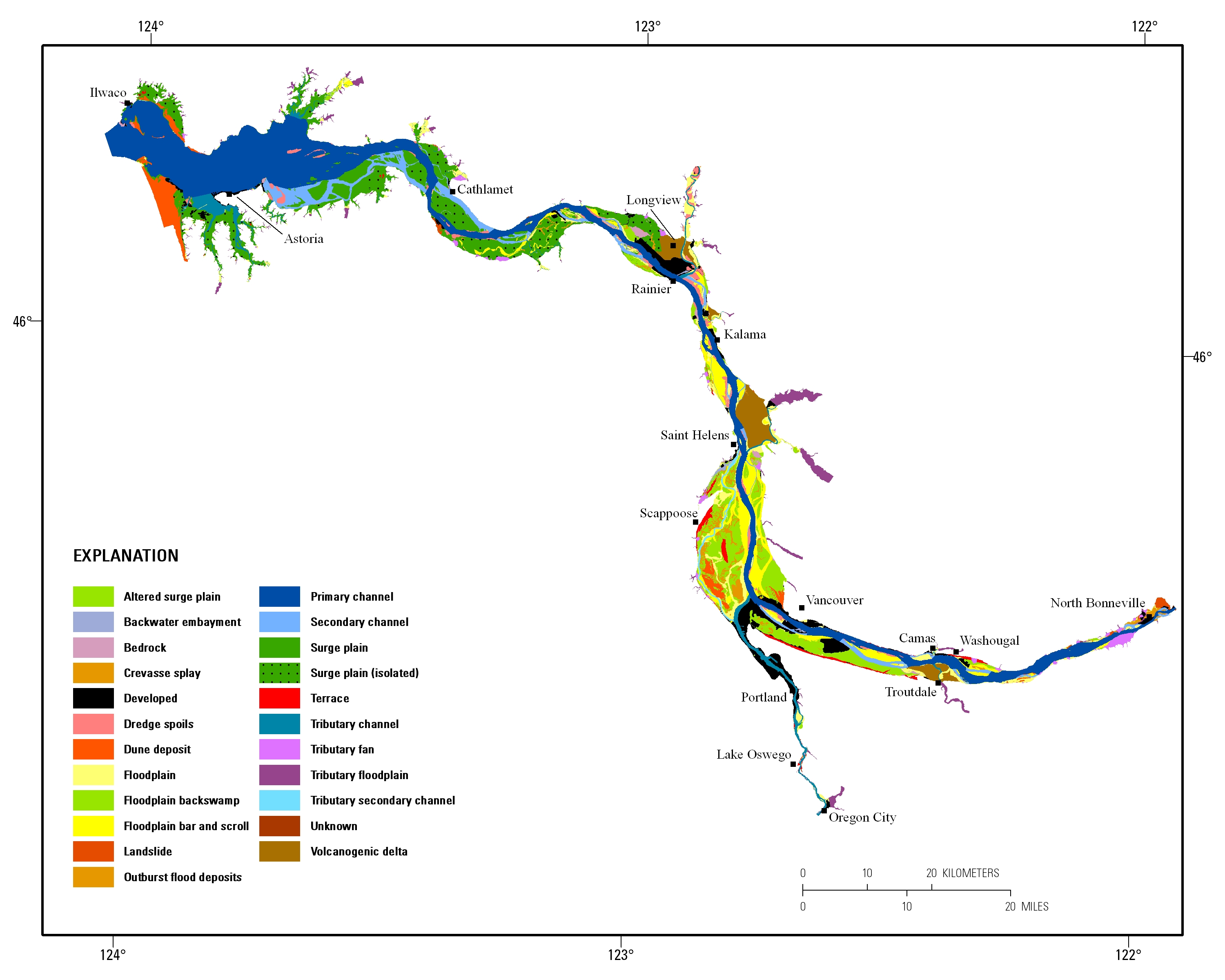
Estuarine ecosystems are controlled by a variety of processes that operate at multiple spatial and temporal scales. Understanding the hierarchical nature of these processes will aid in prioritization of restoration efforts. This hierarchical Columbia River Estuary Ecosystem Classification (henceforth "Classification") of the Columbia River estuary is a spatial database of the tidally-influenced reaches of the lower Columbia River, the tidally affected parts of its tributaries, and the landforms that make up their floodplains for the 230 kilometers between the Pacific Ocean and Bonneville Dam. This work is a collaborative effort between University of Washington School of Aquatic and Fishery Sciences (henceforth "UW"),...

These data were released prior to the October 1, 2016 effective date for the USGS’s policy dictating the review, approval, and release of scientific data as referenced in USGS Survey Manual Chapter 502.8 Fundamental Science Practices: Review and Approval of Scientific Data for Release. The Umpqua River drains 12,103 square kilometers (4,673 square miles) in southwest Oregon before flowing into the Pacific Ocean at Winchester Bay near the city of Reedsport. In cooperation with the Portland District of the U.S. Army Corps of Engineers (USACE), the USGS evaluated sediment transport and gravel storage along the downstream alluvial reaches of the North and South Umpqua Rivers and the entire mainstem Umpqua River. This...
Categories: pre-SM502.8;
Tags: Douglas County,
NSDI,
Oregon,
USGS Science Data Catalog (SDC),
Umpqua River,
|

|
