Filters: Categories: pre-SM502.8 (X) > partyWithName: Integrated Modeling & Prediction Division (X)
103 results (11ms)|
Filters
Date Range
Contacts
Tag Types Tag Schemes |

These data were released prior to the October 1, 2016 effective date for the USGS’s policy dictating the review, approval, and release of scientific data as referenced in USGS Survey Manual Chapter 502.8 Fundamental Science Practices: Review and Approval of Scientific Data for Release. This tabular data set represents the total amount of nitrogen and phosphorus, in kilograms for the year 2002, compiled for every MRB_E2RF1 catchment of the Major River Basins (MRBs, Crawford and others, 2006). The source data set is County-Level Estimates of Nutrient Inputs to the Land Surface of the Conterminous United States, 1982-2001 (Ruddy and others, 2006). The MRB_E2RF1 catchments are based on a modified version of the U.S....

These data were released prior to the October 1, 2016 effective date for the USGS’s policy dictating the review, approval, and release of scientific data as referenced in USGS Survey Manual Chapter 502.8 Fundamental Science Practices: Review and Approval of Scientific Data for Release. This 30-meter resolution raster data set of land cover for the conterminous United States ("NLCDep0905") was designed to describe conditions representative of the year 2000 and is the result of overlaying enhanced 1992 National Land Cover Data with 2000 population data at the block group geographic level. Any area (excluding water, developed land, or wetlands) with population density of at least 1,000 people per square mile was reclassified...
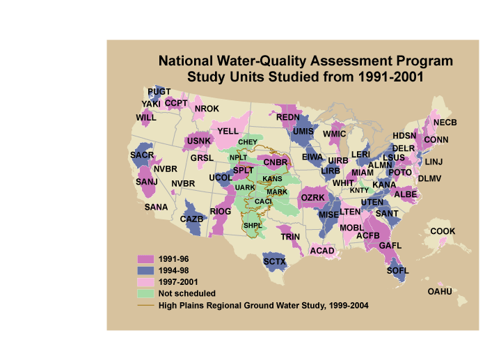
These data were released prior to the October 1, 2016 effective date for the USGS’s policy dictating the review, approval, and release of scientific data as referenced in USGS Survey Manual Chapter 502.8 Fundamental Science Practices: Review and Approval of Scientific Data for Release. This is a coverage of the boundaries and codes used for the U.S. Geological Survey's National Water-Quality Assessment (NAWQA) Program Study-Unit investigations in the conterminous United States, excluding the High Plains Regional Ground-Water Study. The data set represents the areas studied during the first decade of the NAWQA Program, from 1991-2001 ("cycle 1").
Categories: pre-SM502.8;
Tags: Aquifer system,
Conterminous United States,
Ground water,
NAWQA,
NSDI,

These data were released prior to the October 1, 2016 effective date for the USGS’s policy dictating the review, approval, and release of scientific data as referenced in USGS Survey Manual Chapter 502.8 Fundamental Science Practices: Review and Approval of Scientific Data for Release. Digital hydrogeologic surface of the Lower Claiborne aquifer in Alabama, Arkansas, Louisiana, and Mississippi. The hydrogeologic unit dataset contains 414 rows and 394 columns representing 1-mile grid spacing. In general, limitations of data interpolation included areas of sparse geophysical log control points, log datums not clearly defined for some logs, unknown exact extent of each hydrogeologic unit in subcrop, interpolation...
Categories: pre-SM502.8;
Tags: East Gulf Coastal Plain,
GIS,
MERAS,
Mississippi Alluvial Plain,
Mississippi Embayment Regional Aquifer Study,

These data were released prior to the October 1, 2016 effective date for the USGS’s policy dictating the review, approval, and release of scientific data as referenced in USGS Survey Manual Chapter 502.8 Fundamental Science Practices: Review and Approval of Scientific Data for Release. During 2008, the U.S. Geological Survey and other agencies made approximately 2,500 water-level measurements in the Mojave River and Morongo groundwater basins. These data document recent conditions and, when compared with previous data, changes in groundwater levels. A water-level contour map was drawn using data from about 700 wells, providing coverage for most of the basins. Twenty-four hydrographs show long-term (up to 70 years)...

These data were released prior to the October 1, 2016 effective date for the USGS’s policy dictating the review, approval, and release of scientific data as referenced in USGS Survey Manual Chapter 502.8 Fundamental Science Practices: Review and Approval of Scientific Data for Release. This is a 1:2,000,000 coverage of streams for the conterminous United States.
These data were released prior to the October 1, 2016 effective date for the USGS’s policy dictating the review, approval, and release of scientific data as referenced in USGS Survey Manual Chapter 502.8 Fundamental Science Practices: Review and Approval of Scientific Data for Release. This data set is a national map of predicted probability of nitrate contamination of shallow ground waters based on a logistic regression (LR) model. The LR model was used to predict the probability of nitrate contamination exceeding 4 mg/L in predominantly shallow, recently recharged ground waters of the United States. The model contains variables representing (1) nitrogen (N) fertilizer loading, (2) percent cropland-pasture, (3)...

These data were released prior to the October 1, 2016 effective date for the USGS’s policy dictating the review, approval, and release of scientific data as referenced in USGS Survey Manual Chapter 502.8 Fundamental Science Practices: Review and Approval of Scientific Data for Release. The Rogue River drains 13,390 square kilometers of southwestern Oregon before flowing into the Pacific Ocean near the town of Gold Beach, Oregon. The Rogue River begins in the Cascade Range and traverses the Klamath Mountains, where it gains its largest tributaries, the Applegate (1,994 square kilometers) and Illinois (2,564 square kilometers) Rivers, on its way to the coast. In cooperation with the U.S. Army Corps of Engineers,...
Categories: pre-SM502.8;
Tags: Applegate River,
Curry County,
Illinois River,
Jackson County,
Josephine County,

These data were released prior to the October 1, 2016 effective date for the USGS’s policy dictating the review, approval, and release of scientific data as referenced in USGS Survey Manual Chapter 502.8 Fundamental Science Practices: Review and Approval of Scientific Data for Release. Hunter Creek is an unregulated system that drains 115 square kilometers of southwestern Oregon before flowing into the Pacific Ocean south of the town of Gold Beach, Oregon. In cooperation with the U.S. Army Corps of Engineers, the U.S. Geological Survey completed a reconnaissance-level assessment of channel condition and bed-material transport relevant to the permitting of in-stream gravel extraction in the lower 12.4 kilometers...
Categories: pre-SM502.8;
Tags: Curry County,
Hunter Creek,
NSDI,
Oregon Coast Range,
USGS Science Data Catalog (SDC),

These data were released prior to the October 1, 2016 effective date for the USGS’s policy dictating the review, approval, and release of scientific data as referenced in USGS Survey Manual Chapter 502.8 Fundamental Science Practices: Review and Approval of Scientific Data for Release. This data set represents the extent of the Coastal lowlands aquifer system in the states of Texas, Louisiana, Mississippi, Alabama, and Florida.
These data were released prior to the October 1, 2016 effective date for the USGS’s policy dictating the review, approval, and release of scientific data as referenced in USGS Survey Manual Chapter 502.8 Fundamental Science Practices: Review and Approval of Scientific Data for Release. Point coverage of bathymetry data for Lake Darling in Washington Co., Iowa. The U.S. Geological Survey conducted a bathymetric survey of Lake Darling in 2004.

These data were released prior to the October 1, 2016 effective date for the USGS’s policy dictating the review, approval, and release of scientific data as referenced in USGS Survey Manual Chapter 502.8 Fundamental Science Practices: Review and Approval of Scientific Data for Release. With increasing population growth and land-use change, urban communities in the desert southwest are progressively looking to remote basins to supplement existing water supplies. Recent applications for groundwater appropriations from Dixie Valley, Nevada, a primarily undeveloped basin neighboring the Carson Desert to the east, have prompted a reevaluation of the quantity of naturally discharging groundwater.The objective of this...

These data were released prior to the October 1, 2016 effective date for the USGS’s policy dictating the review, approval, and release of scientific data as referenced in USGS Survey Manual Chapter 502.8 Fundamental Science Practices: Review and Approval of Scientific Data for Release. Point coverage of bathymetry data for Upper Gar Lake in Dickinson Co., Iowa. The U.S. Geological Survey conducted a bathymetric survey of Upper Gar Lake in 2004.
These data were released prior to the October 1, 2016 effective date for the USGS’s policy dictating the review, approval, and release of scientific data as referenced in USGS Survey Manual Chapter 502.8 Fundamental Science Practices: Review and Approval of Scientific Data for Release. This data set consists of digital bathymetry contours for Lake Minnewashta in Dickinson Co., Iowa. The U.S. Geological Survey conducted a bathymetric survey of Lake Minnewashta in 2004.

These data were released prior to the October 1, 2016 effective date for the USGS’s policy dictating the review, approval, and release of scientific data as referenced in USGS Survey Manual Chapter 502.8 Fundamental Science Practices: Review and Approval of Scientific Data for Release. This data set represents 1990 block group population density, in people per square kilometer, in the conterminous United States. This data set represents The data set was used as an input data layer for a national model to predict nitrate concentration in ground water used for drinking. Nolan and Hitt (2006) developed two national models to predict contamination of ground water by nonpoint sources of nitrate. The nonlinear approach...
Categories: pre-SM502.8;
Tags: Conterminous United States,
Drinking water,
Ground water,
Ground water contamination,
Ground water pollution,

These data were released prior to the October 1, 2016 effective date for the USGS’s policy dictating the review, approval, and release of scientific data as referenced in USGS Survey Manual Chapter 502.8 Fundamental Science Practices: Review and Approval of Scientific Data for Release. This data set represents the percent of cropland/pasture/fallow land cover in the conterminous United States. The data set was used as an input data layer for a national model to predict nitrate concentration in shallow ground water. Nolan and Hitt (2006) developed two national models to predict contamination of ground water by nonpoint sources of nitrate. The nonlinear approach to national-scale Ground-WAter Vulnerability Assessment...
Categories: pre-SM502.8;
Tags: Conterminous United States,
Cropland,
Fallow,
Ground water,
Ground water contamination,

These data were released prior to the October 1, 2016 effective date for the USGS’s policy dictating the review, approval, and release of scientific data as referenced in USGS Survey Manual Chapter 502.8 Fundamental Science Practices: Review and Approval of Scientific Data for Release. This data set represents the average annual nitrogen input from confined animal manure, 1992 and 1997, in kilograms per hectare, in the conterminous United States. The data set was used as an input data layer for a national model to predict nitrate concentration in shallow ground water. Nolan and Hitt (2006) developed two national models to predict contamination of ground water by nonpoint sources of nitrate. The nonlinear approach...

These data were released prior to the October 1, 2016 effective date for the USGS’s policy dictating the review, approval, and release of scientific data as referenced in USGS Survey Manual Chapter 502.8 Fundamental Science Practices: Review and Approval of Scientific Data for Release. Hydrologic landscape regions group areas according to their similarity in landscape and climate characteristics. These characteristics represent variables assumed to affect hydrologic processes in the environment. Hydrologic landscape regions in Nevada were delineated using geographic information system tools and statistical methods including cluster analysis. The data layers of hydrogeology, precipitation, soil permeability, land...
Categories: pre-SM502.8;
Tags: Great Basin,
NSDI,
Nevada,
USGS Science Data Catalog (SDC),
environment,

These data were released prior to the October 1, 2016 effective date for the USGS’s policy dictating the review, approval, and release of scientific data as referenced in USGS Survey Manual Chapter 502.8 Fundamental Science Practices: Review and Approval of Scientific Data for Release. This data set consists of hydrographic area and major flow system boundaries and polygons delineated at 1:1,000,000-scale for the Great Basin.
|

|
