Filters: partyWithName: Integrated Modeling &Prediction Division (X)
67 results (49ms)|
Filters
Date Range
Contacts
Categories Tag Types Tag Schemes |

These data were released prior to the October 1, 2016 effective date for the USGS’s policy dictating the review, approval, and release of scientific data as referenced in USGS Survey Manual Chapter 502.8 Fundamental Science Practices: Review and Approval of Scientific Data for Release. This data set represents the extent of the Columbia Plateau aquifer system in the states of Washington, Oregon, and Idaho.

1992 Water-Table Contours of the Mojave River Ground-Water Basin, San Bernardino County, California.
These data were released prior to the October 1, 2016 effective date for the USGS’s policy dictating the review, approval, and release of scientific data as referenced in USGS Survey Manual Chapter 502.8 Fundamental Science Practices: Review and Approval of Scientific Data for Release. This data set consists of digital water-table contours for the Mojave River Basin. The U.S. Geological Survey, in cooperation with the Mojave Water Agency, constructed a water-table map of the Mojave River ground-water basin for ground-water levels measured in November 1992. Water-level data were collected from approximately 300 wells to construct the contours. The water-table contours were digitized from the paper map which was...
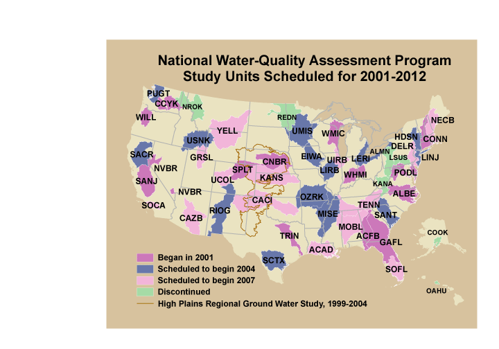
These data were released prior to the October 1, 2016 effective date for the USGS’s policy dictating the review, approval, and release of scientific data as referenced in USGS Survey Manual Chapter 502.8 Fundamental Science Practices: Review and Approval of Scientific Data for Release. This is a GENERALIZED version of the boundaries and codes used for the U.S. Geological Survey's National Water-Quality Assessment (NAWQA) Program Study-Unit investigations in the conterminous United States, excluding the High Plains Regional Ground-Water Study. The data set represents the areas to be studied during the second decade of the NAWQA Program, from 2001-2012 ("cycle 2"). The coverage is intended only for drawing ILLUSTRATIONS,...

These data were released prior to the October 1, 2016 effective date for the USGS’s policy dictating the review, approval, and release of scientific data as referenced in USGS Survey Manual Chapter 502.8 Fundamental Science Practices: Review and Approval of Scientific Data for Release. During 2010, the U.S. Geological Survey and other agencies made approximately 2,500 water-level measurements in the Mojave River and Morongo groundwater basins. These data document recent conditions and, when compared with previous data, changes in groundwater levels. A water-level contour map was drawn using data from about 610 wells, providing coverage for most of the basins. Twenty-eight hydrographs show long-term (up to 70 years)...

These data were released prior to the October 1, 2016 effective date for the USGS’s policy dictating the review, approval, and release of scientific data as referenced in USGS Survey Manual Chapter 502.8 Fundamental Science Practices: Review and Approval of Scientific Data for Release. This data set consists of digital water-table contours for the Mojave River and the Morongo Ground-Water Basins. The U.S. Geological Survey constructed a water-table map of the Mojave River and the Morongo Ground-Water Basins for ground-water levels measured during the spring of 1998. Water-level data were collected from 418 wells to construct the contours. The water-table contours were digitized from the paper map which was published...

These data were released prior to the October 1, 2016 effective date for the USGS’s policy dictating the review, approval, and release of scientific data as referenced in USGS Survey Manual Chapter 502.8 Fundamental Science Practices: Review and Approval of Scientific Data for Release. This data set represents predicted nitrate concentration in ground water used for drinking, in milligrams per liter, in the conterminous United States, and was generated by a national nonlinear regression model based on 14 input parameters. Nolan and Hitt (2006) developed two national models to predict contamination of ground water by nonpoint sources of nitrate. The nonlinear approach to national-scale Ground-WAter Vulnerability...

These data were released prior to the October 1, 2016 effective date for the USGS’s policy dictating the review, approval, and release of scientific data as referenced in USGS Survey Manual Chapter 502.8 Fundamental Science Practices: Review and Approval of Scientific Data for Release. This data set represents the percent of woody wetlands and emergent herbaceous wetlands land cover in the conterminous United States. The data set was used as an input data layer for a national model to predict nitrate concentration in shallow ground water. Nolan and Hitt (2006) developed two national models to predict contamination of ground water by nonpoint sources of nitrate. The nonlinear approach to national-scale Ground-WAter...
These data were released prior to the October 1, 2016 effective date for the USGS’s policy dictating the review, approval, and release of scientific data as referenced in USGS Survey Manual Chapter 502.8 Fundamental Science Practices: Review and Approval of Scientific Data for Release. The digital segmented network based on watershed boundaries, ERF1_2, includes enhancements to the U.S. Environmental Protection Agency's River Reach File 1 (RF1) (USEPA, 1996; DeWald and others, 1985) to support national and regional-scale surface water-quality modeling. Alexander and others (1999) developed ERF1, which assessed the hydrologic integrity of the digital reach traces and calculated the mean water time-of-travel in river...

These data were released prior to the October 1, 2016 effective date for the USGS’s policy dictating the review, approval, and release of scientific data as referenced in USGS Survey Manual Chapter 502.8 Fundamental Science Practices: Review and Approval of Scientific Data for Release. Locations of NASQAN benchmark stations.

These data were released prior to the October 1, 2016 effective date for the USGS’s policy dictating the review, approval, and release of scientific data as referenced in USGS Survey Manual Chapter 502.8 Fundamental Science Practices: Review and Approval of Scientific Data for Release. This data set consists of digital water-table contours for the Mojave River and the Morongo Ground-Water Basins. The U.S. Geological Survey constructed a water-table map of the Mojave River and the Morongo Ground-Water Basins for ground-water levels measured during the spring of 2000. Water-level data were collected from 498 wells to construct the contours. The water-table contours were digitized from the paper map which was published...
These data were released prior to the October 1, 2016 effective date for the USGS’s policy dictating the review, approval, and release of scientific data as referenced in USGS Survey Manual Chapter 502.8 Fundamental Science Practices: Review and Approval of Scientific Data for Release. This is a coverage of the boundaries and codes used for the U.S. Geological Survey's National Water-Quality Assessment (NAWQA) Program Study-Unit investigations in the conterminous United States, excluding the High Plains Regional Ground-Water Study. The data set represents the areas to be studied during the second cycle of the NAWQA Program, from 2001-2012 ("cycle 2").

These data were released prior to the October 1, 2016 effective date for the USGS’s policy dictating the review, approval, and release of scientific data as referenced in USGS Survey Manual Chapter 502.8 Fundamental Science Practices: Review and Approval of Scientific Data for Release. This data set consists of digital water-table contours for the Mojave River, the Morongo and the Fort Irwin Ground-Water Basins. The U.S. Geological Survey constructed a water-table map of the Mojave River, the Morongo and the Fort Irwin Ground-Water Basins for ground-water levels measured during the period January-September 1996. Water-level data were collected from 632 wells to construct the contours. The water-table contours were...

These data were released prior to the October 1, 2016 effective date for the USGS’s policy dictating the review, approval, and release of scientific data as referenced in USGS Survey Manual Chapter 502.8 Fundamental Science Practices: Review and Approval of Scientific Data for Release. This data set represents the presence or absence of poorly sorted glacial till east of the Rocky Mountains in the conterminous United States. The data set was used as an input data layer for a national model to predict nitrate concentration in ground water used for drinking. Nolan and Hitt (2006) developed two national models to predict contamination of ground water by nonpoint sources of nitrate. The nonlinear approach to national-scale...

These data were released prior to the October 1, 2016 effective date for the USGS’s policy dictating the review, approval, and release of scientific data as referenced in USGS Survey Manual Chapter 502.8 Fundamental Science Practices: Review and Approval of Scientific Data for Release. This data set represents the presence or absence of sandstone and carbonate rock aquifers in the conterminous United States. The data set was used as an input data layer for a national model to predict nitrate concentration in ground water used for drinking. Nolan and Hitt (2006) developed two national models to predict contamination of ground water by nonpoint sources of nitrate. The nonlinear approach to national-scale Ground-WAter...

These data were released prior to the October 1, 2016 effective date for the USGS’s policy dictating the review, approval, and release of scientific data as referenced in USGS Survey Manual Chapter 502.8 Fundamental Science Practices: Review and Approval of Scientific Data for Release. This is a point coverage of landfills shown in the 1986 National Water Summary Report (U.S. Geological Survey, 1987). Keywords landfill
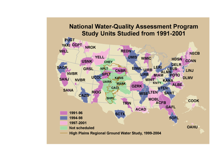
These data were released prior to the October 1, 2016 effective date for the USGS’s policy dictating the review, approval, and release of scientific data as referenced in USGS Survey Manual Chapter 502.8 Fundamental Science Practices: Review and Approval of Scientific Data for Release. This is a coverage of the boundaries and codes used for the U.S. Geological Survey's National Water-Quality Assessment (NAWQA) Program Study-Unit investigations in the conterminous United States, excluding the High Plains Regional Ground-Water Study. The data set represents the areas studied during the first decade of the NAWQA Program, from 1991-2001 ("cycle 1").
Categories: pre-SM502.8;
Tags: Aquifer system,
Conterminous United States,
Ground water,
NAWQA,
NSDI,

These data were released prior to the October 1, 2016 effective date for the USGS’s policy dictating the review, approval, and release of scientific data as referenced in USGS Survey Manual Chapter 502.8 Fundamental Science Practices: Review and Approval of Scientific Data for Release. This is a 1:2,000,000 coverage of streams for the conterminous United States.
These data were released prior to the October 1, 2016 effective date for the USGS’s policy dictating the review, approval, and release of scientific data as referenced in USGS Survey Manual Chapter 502.8 Fundamental Science Practices: Review and Approval of Scientific Data for Release. This data set is a national map of predicted probability of nitrate contamination of shallow ground waters based on a logistic regression (LR) model. The LR model was used to predict the probability of nitrate contamination exceeding 4 mg/L in predominantly shallow, recently recharged ground waters of the United States. The model contains variables representing (1) nitrogen (N) fertilizer loading, (2) percent cropland-pasture, (3)...

These data were released prior to the October 1, 2016 effective date for the USGS’s policy dictating the review, approval, and release of scientific data as referenced in USGS Survey Manual Chapter 502.8 Fundamental Science Practices: Review and Approval of Scientific Data for Release. This data set represents the extent of the Coastal lowlands aquifer system in the states of Texas, Louisiana, Mississippi, Alabama, and Florida.

These data were released prior to the October 1, 2016 effective date for the USGS’s policy dictating the review, approval, and release of scientific data as referenced in USGS Survey Manual Chapter 502.8 Fundamental Science Practices: Review and Approval of Scientific Data for Release. This data set represents 1990 block group population density, in people per square kilometer, in the conterminous United States. This data set represents The data set was used as an input data layer for a national model to predict nitrate concentration in ground water used for drinking. Nolan and Hitt (2006) developed two national models to predict contamination of ground water by nonpoint sources of nitrate. The nonlinear approach...
Categories: pre-SM502.8;
Tags: Conterminous United States,
Drinking water,
Ground water,
Ground water contamination,
Ground water pollution,
|

|
