Filters: Date Range: {"choice":"week"} (X) > Tags: {"scheme":"ISO 19115 Topic Category"} (X) > partyWithName: U.S. Geological Survey (X)
Folder: ROOT ( Show direct descendants )
38,244 results (129ms)
LocationFilters
Date Types (for Date Range)
Types Contacts
Categories Tag Types Tags (with Scheme=ISO 19115 Topic Category) |
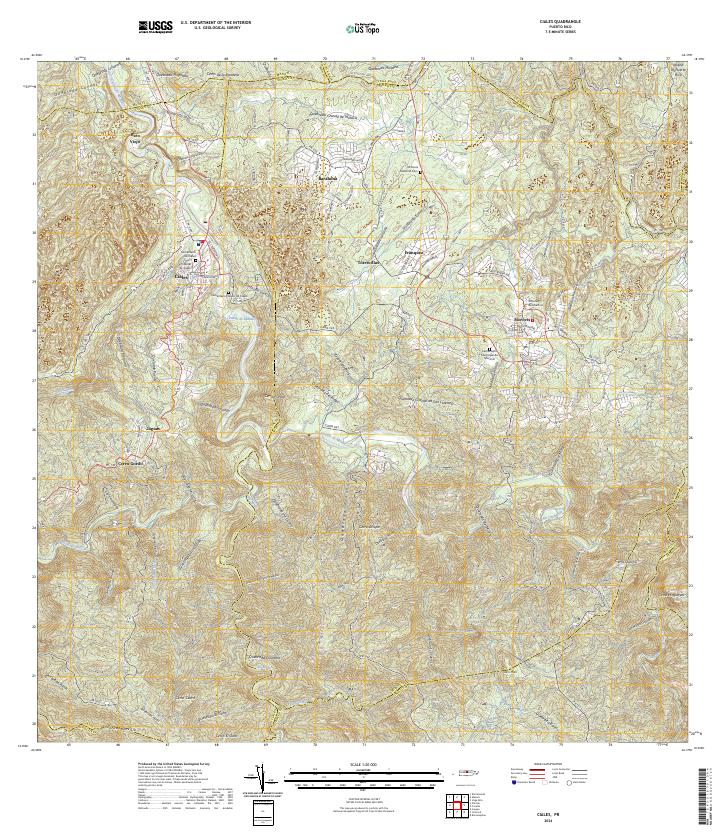
Layered geospatial PDF 7.5 Minute Quadrangle Map. Layers of geospatial data include orthoimagery, roads, grids, geographic names, elevation contours, hydrography, and other selected map features. This map is derived from GIS (geospatial information system) data. It represents a repackaging of GIS data in traditional map form, not creation of new information. The geospatial data in this map are from selected National Map data holdings and other government sources.
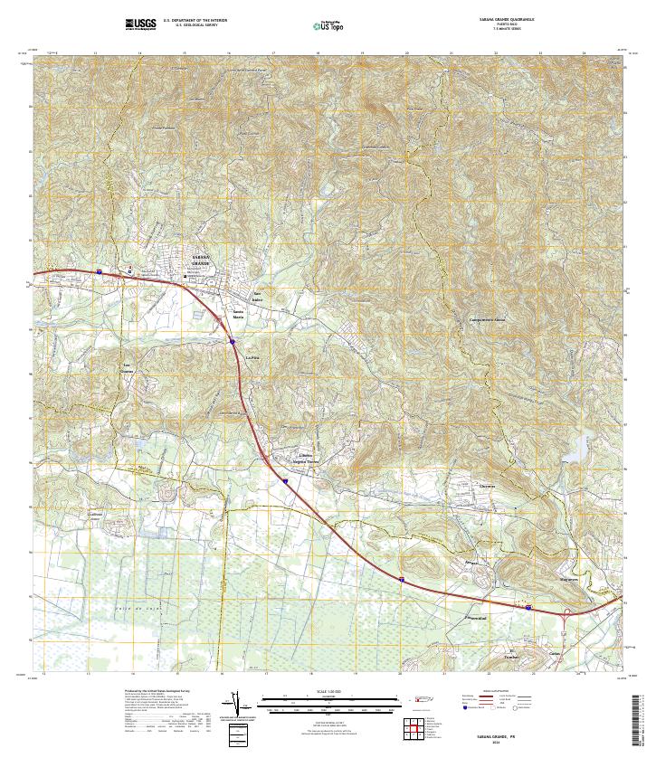
Layered geospatial PDF 7.5 Minute Quadrangle Map. Layers of geospatial data include orthoimagery, roads, grids, geographic names, elevation contours, hydrography, and other selected map features. This map is derived from GIS (geospatial information system) data. It represents a repackaging of GIS data in traditional map form, not creation of new information. The geospatial data in this map are from selected National Map data holdings and other government sources.
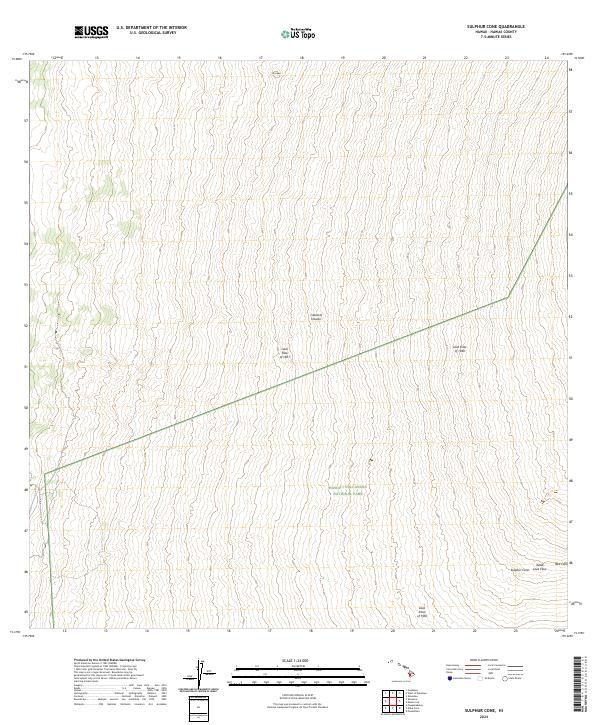
Layered geospatial PDF 7.5 Minute Quadrangle Map. Layers of geospatial data include orthoimagery, roads, grids, geographic names, elevation contours, hydrography, and other selected map features. This map is derived from GIS (geospatial information system) data. It represents a repackaging of GIS data in traditional map form, not creation of new information. The geospatial data in this map are from selected National Map data holdings and other government sources.
Layered geospatial PDF 7.5 Minute Quadrangle Map. Layers of geospatial data include orthoimagery, roads, grids, geographic names, elevation contours, hydrography, and other selected map features. This map is derived from GIS (geospatial information system) data. It represents a repackaging of GIS data in traditional map form, not creation of new information. The geospatial data in this map are from selected National Map data holdings and other government sources.

This is the Original Product Resolution (OPR) Digital Elevation Model (DEM) as provided to the USGS. This DEM is delivered in the original resolution, with the original spatial reference. These data may be used as the source of updates to the seamless layers of the 3D Elevation Program, which serves as the elevation layer of the National Map. These data can be used by scientists and resource managers for global change research, hydrologic modeling, resource monitoring, mapping and visualization, and many other applications.

This is the Original Product Resolution (OPR) Digital Elevation Model (DEM) as provided to the USGS. This DEM is delivered in the original resolution, with the original spatial reference. These data may be used as the source of updates to the seamless layers of the 3D Elevation Program, which serves as the elevation layer of the National Map. These data can be used by scientists and resource managers for global change research, hydrologic modeling, resource monitoring, mapping and visualization, and many other applications.

This is the Original Product Resolution (OPR) Digital Elevation Model (DEM) as provided to the USGS. This DEM is delivered in the original resolution, with the original spatial reference. These data may be used as the source of updates to the seamless layers of the 3D Elevation Program, which serves as the elevation layer of the National Map. These data can be used by scientists and resource managers for global change research, hydrologic modeling, resource monitoring, mapping and visualization, and many other applications.

This is the Original Product Resolution (OPR) Digital Elevation Model (DEM) as provided to the USGS. This DEM is delivered in the original resolution, with the original spatial reference. These data may be used as the source of updates to the seamless layers of the 3D Elevation Program, which serves as the elevation layer of the National Map. These data can be used by scientists and resource managers for global change research, hydrologic modeling, resource monitoring, mapping and visualization, and many other applications.

This is the Original Product Resolution (OPR) Digital Elevation Model (DEM) as provided to the USGS. This DEM is delivered in the original resolution, with the original spatial reference. These data may be used as the source of updates to the seamless layers of the 3D Elevation Program, which serves as the elevation layer of the National Map. These data can be used by scientists and resource managers for global change research, hydrologic modeling, resource monitoring, mapping and visualization, and many other applications.

This is the Original Product Resolution (OPR) Digital Elevation Model (DEM) as provided to the USGS. This DEM is delivered in the original resolution, with the original spatial reference. These data may be used as the source of updates to the seamless layers of the 3D Elevation Program, which serves as the elevation layer of the National Map. These data can be used by scientists and resource managers for global change research, hydrologic modeling, resource monitoring, mapping and visualization, and many other applications.

This is the Original Product Resolution (OPR) Digital Elevation Model (DEM) as provided to the USGS. This DEM is delivered in the original resolution, with the original spatial reference. These data may be used as the source of updates to the seamless layers of the 3D Elevation Program, which serves as the elevation layer of the National Map. These data can be used by scientists and resource managers for global change research, hydrologic modeling, resource monitoring, mapping and visualization, and many other applications.

This is the Original Product Resolution (OPR) Digital Elevation Model (DEM) as provided to the USGS. This DEM is delivered in the original resolution, with the original spatial reference. These data may be used as the source of updates to the seamless layers of the 3D Elevation Program, which serves as the elevation layer of the National Map. These data can be used by scientists and resource managers for global change research, hydrologic modeling, resource monitoring, mapping and visualization, and many other applications.

This is the Original Product Resolution (OPR) Digital Elevation Model (DEM) as provided to the USGS. This DEM is delivered in the original resolution, with the original spatial reference. These data may be used as the source of updates to the seamless layers of the 3D Elevation Program, which serves as the elevation layer of the National Map. These data can be used by scientists and resource managers for global change research, hydrologic modeling, resource monitoring, mapping and visualization, and many other applications.

This is the Original Product Resolution (OPR) Digital Elevation Model (DEM) as provided to the USGS. This DEM is delivered in the original resolution, with the original spatial reference. These data may be used as the source of updates to the seamless layers of the 3D Elevation Program, which serves as the elevation layer of the National Map. These data can be used by scientists and resource managers for global change research, hydrologic modeling, resource monitoring, mapping and visualization, and many other applications.

This is the Original Product Resolution (OPR) Digital Elevation Model (DEM) as provided to the USGS. This DEM is delivered in the original resolution, with the original spatial reference. These data may be used as the source of updates to the seamless layers of the 3D Elevation Program, which serves as the elevation layer of the National Map. These data can be used by scientists and resource managers for global change research, hydrologic modeling, resource monitoring, mapping and visualization, and many other applications.

This is the Original Product Resolution (OPR) Digital Elevation Model (DEM) as provided to the USGS. This DEM is delivered in the original resolution, with the original spatial reference. These data may be used as the source of updates to the seamless layers of the 3D Elevation Program, which serves as the elevation layer of the National Map. These data can be used by scientists and resource managers for global change research, hydrologic modeling, resource monitoring, mapping and visualization, and many other applications.

This is the Original Product Resolution (OPR) Digital Elevation Model (DEM) as provided to the USGS. This DEM is delivered in the original resolution, with the original spatial reference. These data may be used as the source of updates to the seamless layers of the 3D Elevation Program, which serves as the elevation layer of the National Map. These data can be used by scientists and resource managers for global change research, hydrologic modeling, resource monitoring, mapping and visualization, and many other applications.

This is the Original Product Resolution (OPR) Digital Elevation Model (DEM) as provided to the USGS. This DEM is delivered in the original resolution, with the original spatial reference. These data may be used as the source of updates to the seamless layers of the 3D Elevation Program, which serves as the elevation layer of the National Map. These data can be used by scientists and resource managers for global change research, hydrologic modeling, resource monitoring, mapping and visualization, and many other applications.

This is the Original Product Resolution (OPR) Digital Elevation Model (DEM) as provided to the USGS. This DEM is delivered in the original resolution, with the original spatial reference. These data may be used as the source of updates to the seamless layers of the 3D Elevation Program, which serves as the elevation layer of the National Map. These data can be used by scientists and resource managers for global change research, hydrologic modeling, resource monitoring, mapping and visualization, and many other applications.

This is the Original Product Resolution (OPR) Digital Elevation Model (DEM) as provided to the USGS. This DEM is delivered in the original resolution, with the original spatial reference. These data may be used as the source of updates to the seamless layers of the 3D Elevation Program, which serves as the elevation layer of the National Map. These data can be used by scientists and resource managers for global change research, hydrologic modeling, resource monitoring, mapping and visualization, and many other applications.
|

|
