Filters
Date Range
Contacts
Tag Types
Tag Schemes
|
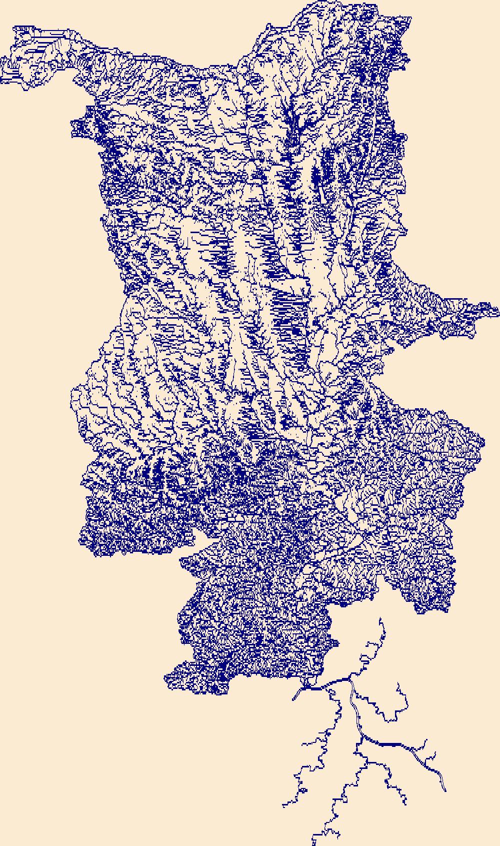
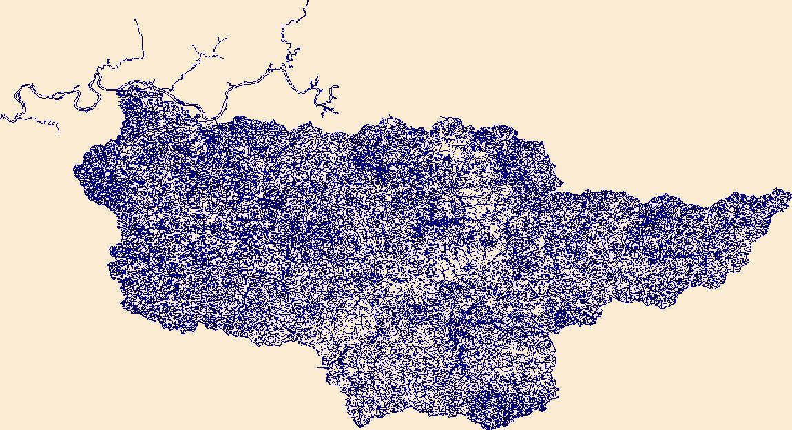
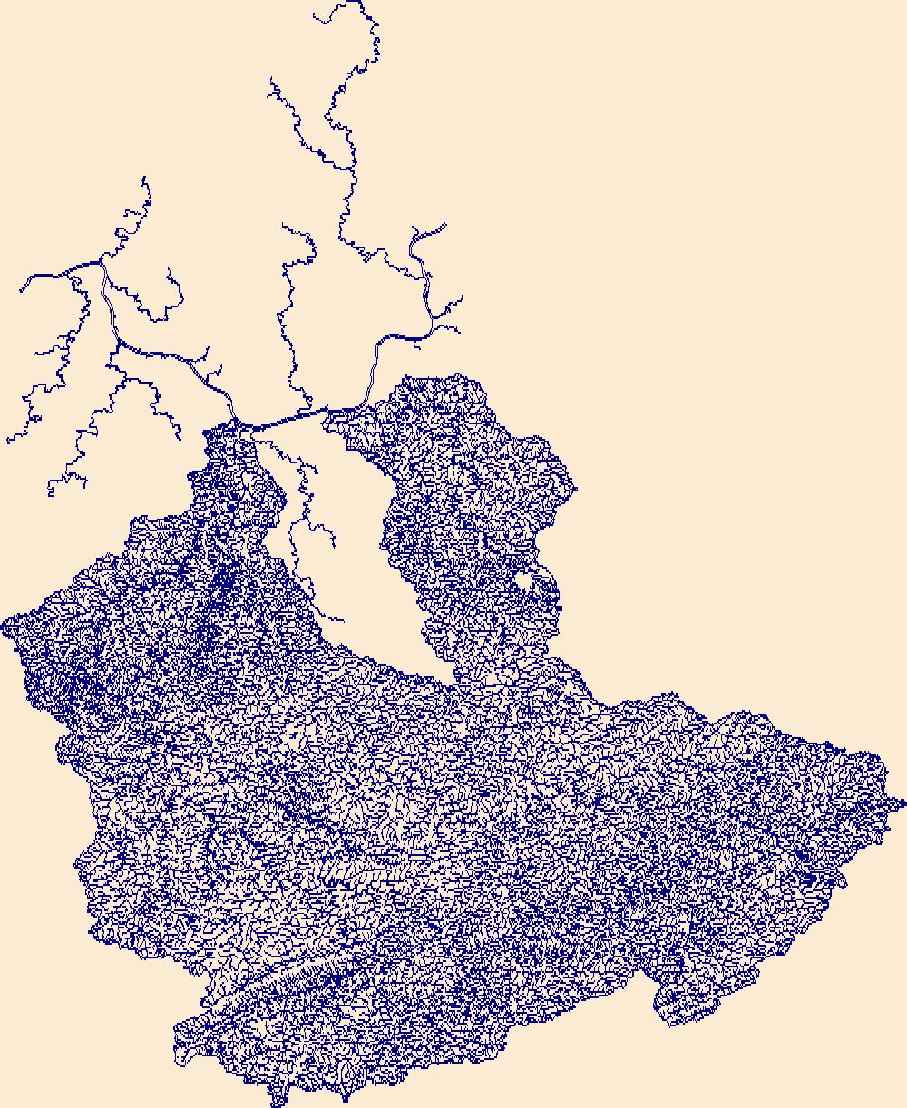
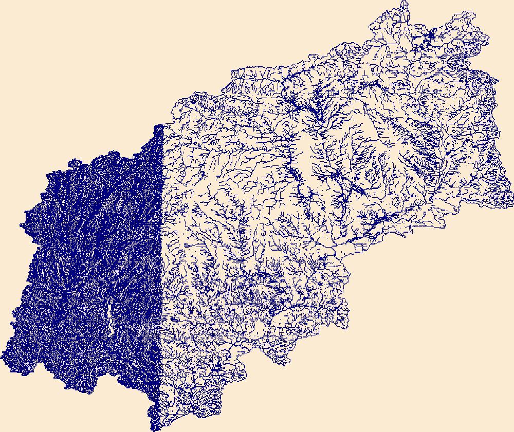
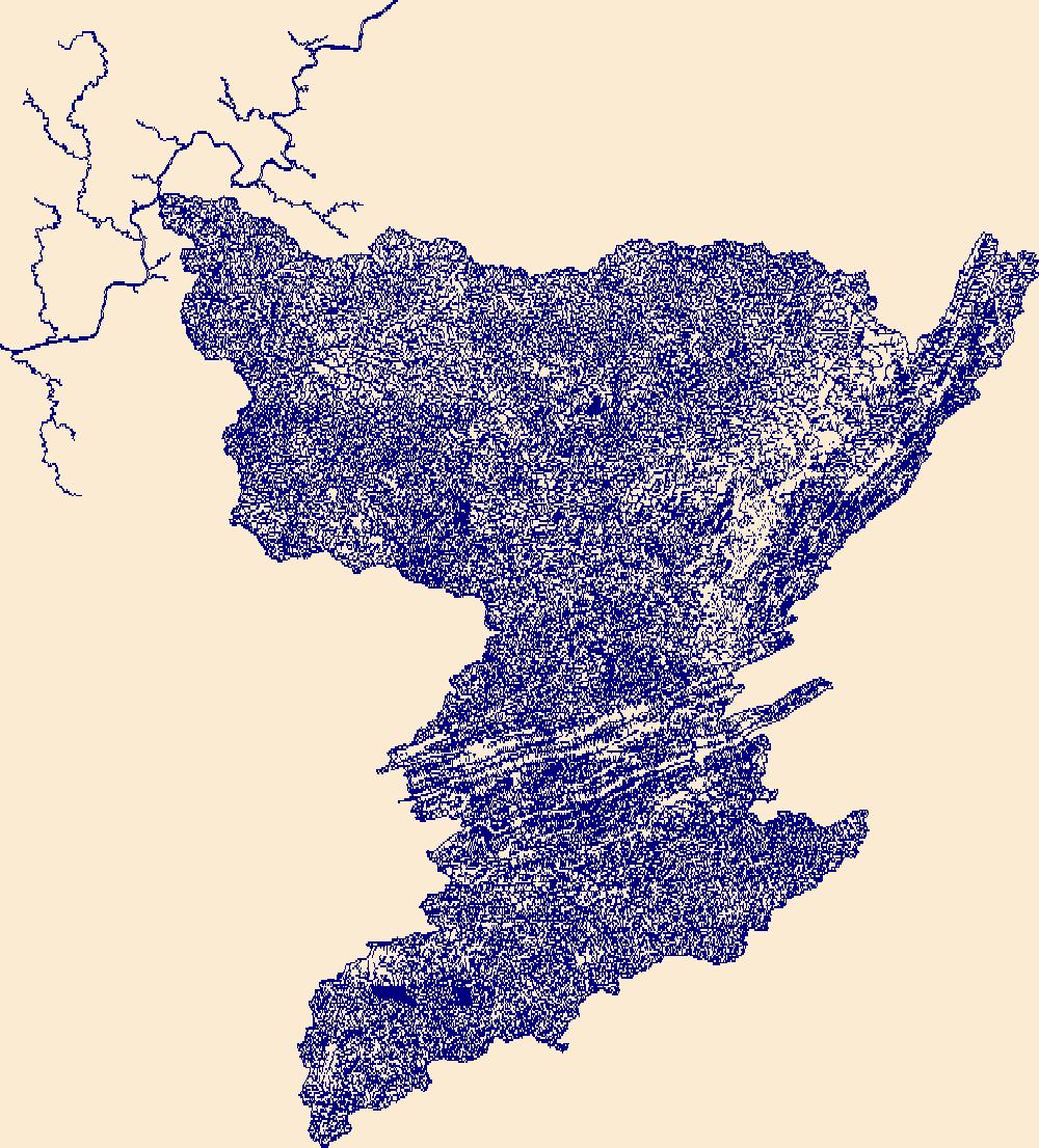
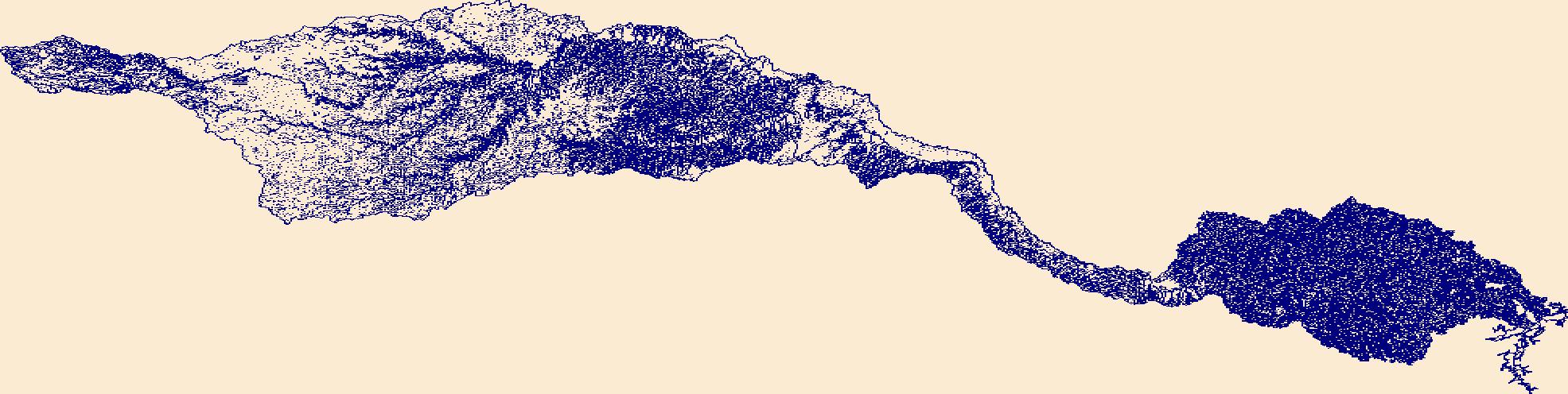
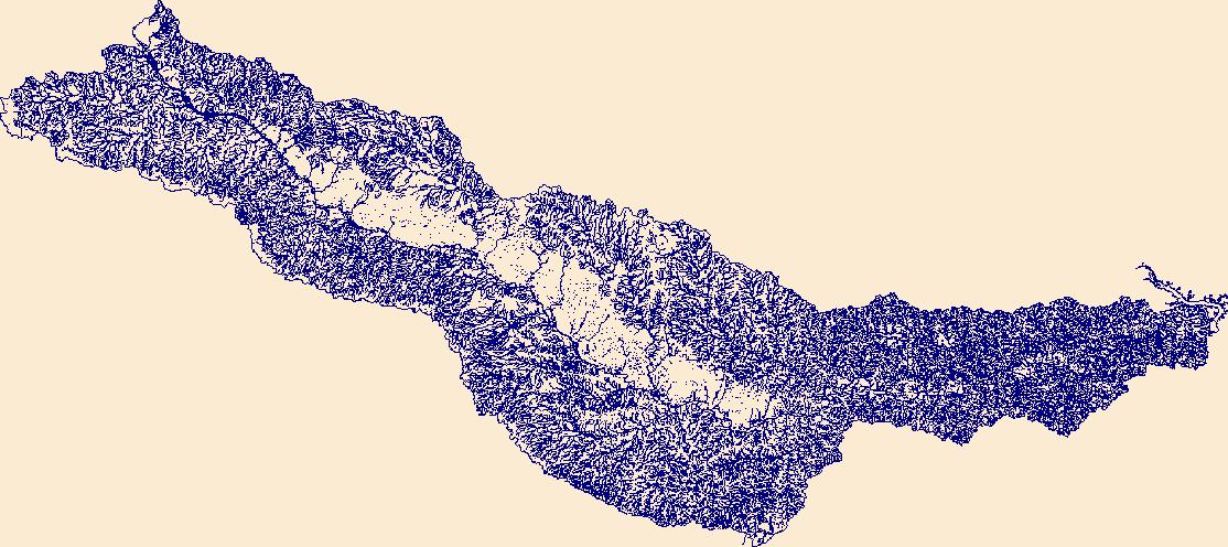
The High Resolution National Hydrography Dataset Plus (NHDPlus HR) is an integrated set of geospatial data layers, including the best available National Hydrography Dataset (NHD), the 10-meter 3D Elevation Program Digital Elevation Model (3DEP DEM), and the National Watershed Boundary Dataset (WBD). The NHDPlus HR combines the NHD, 3DEP DEMs, and WBD to create a stream network with linear referencing, feature naming, "value added attributes" (VAAs), elevation-derived catchments, and other features for hydrologic data analysis. The stream network with linear referencing is a system of data relationships applied to hydrographic systems so that one stream reach "flows" into another and "events" can be tied to and traced...
Tags: Adams County,
Allen County,
Auglaize County,
Champaign County,
Clark County, All tags...
Clinton County,
Crawford County,
Delaware County,
Downloadable Data,
Fairfield County,
Fayette County,
FileGDB,
FileGDB 10.1,
Franklin County,
Greene County,
Greenup County,
HU-4 Subregion,
HU-4 Subregion,
HU4_0506,
Hardin County,
Highland County,
Hocking County,
Hydrography,
Jackson County,
KY,
Kentucky,
Knox County,
Licking County,
Logan County,
Madison County,
Marion County,
Morrow County,
NHDPlus HR Rasters,
NHDPlus High Resolution (NHDPlus HR),
National Hydrography Dataset (NHD),
National Hydrography Dataset Plus High Resolution (NHDPlus HR),
National Hydrography Dataset Plus High Resolution (NHDPlus HR) Current,
OH,
Ohio,
Perry County,
Pickaway County,
Pike County,
Richland County,
Ross County,
Scioto County,
US,
Union County,
United States,
Vinton County,
Wyandot County,
base maps,
cartography,
catchments,
channels,
digital elevation models,
drainage basins,
earth sciences,
elevation,
environment,
geographic information systems,
geoscientific,
geospatial analysis,
hydrographic datasets,
hydrographic features,
hydrology,
imagery,
inland waters,
lakes,
land surface characteristics,
reservoirs,
river reaches,
rivers,
streamflow,
streamflow data,
streams,
topography,
water bodies,
water quality,
water resources,
watersheds, Fewer tags
The High Resolution National Hydrography Dataset Plus (NHDPlus HR) is an integrated set of geospatial data layers, including the best available National Hydrography Dataset (NHD), the 10-meter 3D Elevation Program Digital Elevation Model (3DEP DEM), and the National Watershed Boundary Dataset (WBD). The NHDPlus HR combines the NHD, 3DEP DEMs, and WBD to create a stream network with linear referencing, feature naming, "value added attributes" (VAAs), elevation-derived catchments, and other features for hydrologic data analysis. The stream network with linear referencing is a system of data relationships applied to hydrographic systems so that one stream reach "flows" into another and "events" can be tied to and traced...
Tags: Adair County,
Allen County,
Barren County,
Breckinridge County,
Butler County, All tags...
Casey County,
Christian County,
Clay County,
Daviess County,
Downloadable Data,
Edmonson County,
FileGDB,
FileGDB 10.1,
Grayson County,
Green County,
HU-4 Subregion,
HU-4 Subregion,
HU4_0511,
Hancock County,
Hardin County,
Hart County,
Henderson County,
Hopkins County,
Hydrography,
Jackson County,
KY,
Kentucky,
Larue County,
Lincoln County,
Logan County,
Macon County,
Marion County,
McLean County,
Metcalfe County,
Monroe County,
Muhlenberg County,
NHDPlus HR Rasters,
NHDPlus High Resolution (NHDPlus HR),
National Hydrography Dataset (NHD),
National Hydrography Dataset Plus High Resolution (NHDPlus HR),
National Hydrography Dataset Plus High Resolution (NHDPlus HR) Current,
Ohio County,
Pulaski County,
Robertson County,
Russell County,
Simpson County,
Sumner County,
TN,
Taylor County,
Tennessee,
Todd County,
US,
United States,
Warren County,
Webster County,
base maps,
cartography,
catchments,
channels,
digital elevation models,
drainage basins,
earth sciences,
elevation,
environment,
geographic information systems,
geoscientific,
geospatial analysis,
hydrographic datasets,
hydrographic features,
hydrology,
imagery,
inland waters,
lakes,
land surface characteristics,
reservoirs,
river reaches,
rivers,
streamflow,
streamflow data,
streams,
topography,
water bodies,
water quality,
water resources,
watersheds, Fewer tags
The High Resolution National Hydrography Dataset Plus (NHDPlus HR) is an integrated set of geospatial data layers, including the best available National Hydrography Dataset (NHD), the 10-meter 3D Elevation Program Digital Elevation Model (3DEP DEM), and the National Watershed Boundary Dataset (WBD). The NHDPlus HR combines the NHD, 3DEP DEMs, and WBD to create a stream network with linear referencing, feature naming, "value added attributes" (VAAs), elevation-derived catchments, and other features for hydrologic data analysis. The stream network with linear referencing is a system of data relationships applied to hydrographic systems so that one stream reach "flows" into another and "events" can be tied to and traced...
Tags: Boone County,
Boyd County,
Buchanan County,
Cabell County,
Dickenson County, All tags...
Downloadable Data,
Elliott County,
FileGDB,
FileGDB 10.1,
Floyd County,
HU-4 Subregion,
HU-4 Subregion,
HU4_0507,
Hydrography,
Johnson County,
KY,
Kanawha County,
Kentucky,
Knott County,
Lawrence County,
Letcher County,
Lincoln County,
Logan County,
Magoffin County,
Martin County,
Mason County,
McDowell County,
Mercer County,
Mingo County,
Morgan County,
NHDPlus HR Rasters,
NHDPlus High Resolution (NHDPlus HR),
National Hydrography Dataset (NHD),
National Hydrography Dataset Plus High Resolution (NHDPlus HR),
National Hydrography Dataset Plus High Resolution (NHDPlus HR) Current,
Pike County,
Putnam County,
Raleigh County,
Russell County,
Tazewell County,
US,
United States,
VA,
Virginia,
WV,
Wayne County,
West Virginia,
Wise County,
Wyoming County,
base maps,
cartography,
catchments,
channels,
digital elevation models,
drainage basins,
earth sciences,
elevation,
environment,
geographic information systems,
geoscientific,
geospatial analysis,
hydrographic datasets,
hydrographic features,
hydrology,
imagery,
inland waters,
lakes,
land surface characteristics,
reservoirs,
river reaches,
rivers,
streamflow,
streamflow data,
streams,
topography,
water bodies,
water quality,
water resources,
watersheds, Fewer tags
The High Resolution National Hydrography Dataset Plus (NHDPlus HR) is an integrated set of geospatial data layers, including the best available National Hydrography Dataset (NHD), the 10-meter 3D Elevation Program Digital Elevation Model (3DEP DEM), and the National Watershed Boundary Dataset (WBD). The NHDPlus HR combines the NHD, 3DEP DEMs, and WBD to create a stream network with linear referencing, feature naming, "value added attributes" (VAAs), elevation-derived catchments, and other features for hydrologic data analysis. The stream network with linear referencing is a system of data relationships applied to hydrographic systems so that one stream reach "flows" into another and "events" can be tied to and traced...
Tags: Auglaize County,
Butler County,
Champaign County,
Clark County,
Darke County, All tags...
Dearborn County,
Decatur County,
Downloadable Data,
Fayette County,
FileGDB,
FileGDB 10.1,
Franklin County,
Greene County,
HU-4 Subregion,
HU-4 Subregion,
HU4_0508,
Hamilton County,
Hardin County,
Henry County,
Hydrography,
IN,
Indiana,
Logan County,
Mercer County,
Miami County,
Montgomery County,
NHDPlus HR Rasters,
NHDPlus High Resolution (NHDPlus HR),
National Hydrography Dataset (NHD),
National Hydrography Dataset Plus High Resolution (NHDPlus HR),
National Hydrography Dataset Plus High Resolution (NHDPlus HR) Current,
OH,
Ohio,
Preble County,
Randolph County,
Ripley County,
Rush County,
Shelby County,
US,
Union County,
United States,
Warren County,
Wayne County,
base maps,
cartography,
catchments,
channels,
digital elevation models,
drainage basins,
earth sciences,
elevation,
environment,
geographic information systems,
geoscientific,
geospatial analysis,
hydrographic datasets,
hydrographic features,
hydrology,
imagery,
inland waters,
lakes,
land surface characteristics,
reservoirs,
river reaches,
rivers,
streamflow,
streamflow data,
streams,
topography,
water bodies,
water quality,
water resources,
watersheds, Fewer tags
The High Resolution National Hydrography Dataset Plus (NHDPlus HR) is an integrated set of geospatial data layers, including the best available National Hydrography Dataset (NHD), the 10-meter 3D Elevation Program Digital Elevation Model (3DEP DEM), and the National Watershed Boundary Dataset (WBD). The NHDPlus HR combines the NHD, 3DEP DEMs, and WBD to create a stream network with linear referencing, feature naming, "value added attributes" (VAAs), elevation-derived catchments, and other features for hydrologic data analysis. The stream network with linear referencing is a system of data relationships applied to hydrographic systems so that one stream reach "flows" into another and "events" can be tied to and traced...
Tags: Alleghany County,
Alleghany County,
Ashe County,
Bath County,
Bland County, All tags...
Boone County,
Braxton County,
Cabell County,
Caldwell County,
Calhoun County,
Carroll County,
Clay County,
Craig County,
Downloadable Data,
Fayette County,
FileGDB,
FileGDB 10.1,
Floyd County,
Franklin County,
Galax County,
Giles County,
Grayson County,
Greenbrier County,
HU-4 Subregion,
HU-4 Subregion,
HU4_0505,
Highland County,
Hydrography,
Jackson County,
Johnson County,
Kanawha County,
Lincoln County,
Logan County,
Mason County,
McDowell County,
Mercer County,
Monroe County,
Montgomery County,
NC,
NHDPlus HR Rasters,
NHDPlus High Resolution (NHDPlus HR),
National Hydrography Dataset (NHD),
National Hydrography Dataset Plus High Resolution (NHDPlus HR),
National Hydrography Dataset Plus High Resolution (NHDPlus HR) Current,
Nicholas County,
North Carolina,
Patrick County,
Pendleton County,
Pocahontas County,
Pulaski County,
Putnam County,
Radford County,
Raleigh County,
Randolph County,
Roane County,
Smyth County,
Summers County,
Surry County,
TN,
Tazewell County,
Tennessee,
US,
United States,
VA,
Virginia,
WV,
Washington County,
Watauga County,
Webster County,
West Virginia,
Wilkes County,
Wyoming County,
Wythe County,
base maps,
cartography,
catchments,
channels,
digital elevation models,
drainage basins,
earth sciences,
elevation,
environment,
geographic information systems,
geoscientific,
geospatial analysis,
hydrographic datasets,
hydrographic features,
hydrology,
imagery,
inland waters,
lakes,
land surface characteristics,
reservoirs,
river reaches,
rivers,
streamflow,
streamflow data,
streams,
topography,
water bodies,
water quality,
water resources,
watersheds, Fewer tags

The High Resolution National Hydrography Dataset Plus (NHDPlus HR) is an integrated set of geospatial data layers, including the best available National Hydrography Dataset (NHD), the 10-meter 3D Elevation Program Digital Elevation Model (3DEP DEM), and the National Watershed Boundary Dataset (WBD). The NHDPlus HR combines the NHD, 3DEP DEMs, and WBD to create a stream network with linear referencing, feature naming, "value added attributes" (VAAs), elevation-derived catchments, and other features for hydrologic data analysis. The stream network with linear referencing is a system of data relationships applied to hydrographic systems so that one stream reach "flows" into another and "events" can be tied to and traced...
Tags: Adams County,
Athens County,
Boone County,
Boyd County,
Bracken County, All tags...
Brown County,
Butler County,
Cabell County,
Campbell County,
Carroll County,
Carter County,
Clark County,
Clermont County,
Clinton County,
Dearborn County,
Decatur County,
Downloadable Data,
Elliott County,
Fayette County,
FileGDB,
FileGDB 10.1,
Fleming County,
Franklin County,
Gallatin County,
Gallia County,
Grant County,
Greene County,
Greenup County,
HU-4 Subregion,
HU-4 Subregion,
HU4_0509,
Hamilton County,
Highland County,
Hocking County,
Hydrography,
IN,
Indiana,
Jackson County,
KY,
Kenton County,
Kentucky,
Lawrence County,
Lawrence County,
Lewis County,
Lincoln County,
Logan County,
Madison County,
Mason County,
Mason County,
Meigs County,
Mingo County,
Montgomery County,
Morgan County,
NHDPlus HR Rasters,
NHDPlus High Resolution (NHDPlus HR),
National Hydrography Dataset (NHD),
National Hydrography Dataset Plus High Resolution (NHDPlus HR),
National Hydrography Dataset Plus High Resolution (NHDPlus HR) Current,
OH,
Ohio,
Ohio County,
Pendleton County,
Pike County,
Putnam County,
Ripley County,
Ross County,
Rowan County,
Scioto County,
Switzerland County,
US,
United States,
Vinton County,
WV,
Warren County,
Wayne County,
West Virginia,
base maps,
cartography,
catchments,
channels,
digital elevation models,
drainage basins,
earth sciences,
elevation,
environment,
geographic information systems,
geoscientific,
geospatial analysis,
hydrographic datasets,
hydrographic features,
hydrology,
imagery,
inland waters,
lakes,
land surface characteristics,
reservoirs,
river reaches,
rivers,
streamflow,
streamflow data,
streams,
topography,
water bodies,
water quality,
water resources,
watersheds, Fewer tags

The High Resolution National Hydrography Dataset Plus (NHDPlus HR) is an integrated set of geospatial data layers, including the best available National Hydrography Dataset (NHD), the 10-meter 3D Elevation Program Digital Elevation Model (3DEP DEM), and the National Watershed Boundary Dataset (WBD). The NHDPlus HR combines the NHD, 3DEP DEMs, and WBD to create a stream network with linear referencing, feature naming, "value added attributes" (VAAs), elevation-derived catchments, and other features for hydrologic data analysis. The stream network with linear referencing is a system of data relationships applied to hydrographic systems so that one stream reach "flows" into another and "events" can be tied to and traced...
Tags: AR,
Adair County,
Arkansas,
Benton County,
Cherokee County, All tags...
Cleburne County,
Conway County,
Crawford County,
Creek County,
Delaware County,
Downloadable Data,
Faulkner County,
FileGDB,
FileGDB 10.1,
Franklin County,
Garland County,
Grant County,
HU-4 Subregion,
HU-4 Subregion,
HU4_1111,
Haskell County,
Hydrography,
Jefferson County,
Johnson County,
Latimer County,
Le Flore County,
Logan County,
Lonoke County,
Madison County,
McIntosh County,
Montgomery County,
Muskogee County,
NHDPlus HR Rasters,
NHDPlus High Resolution (NHDPlus HR),
National Hydrography Dataset (NHD),
National Hydrography Dataset Plus High Resolution (NHDPlus HR),
National Hydrography Dataset Plus High Resolution (NHDPlus HR) Current,
Newton County,
OK,
Oklahoma,
Okmulgee County,
Osage County,
Perry County,
Pittsburg County,
Polk County,
Pope County,
Pulaski County,
Saline County,
Scott County,
Searcy County,
Sebastian County,
Sequoyah County,
Tulsa County,
US,
United States,
Van Buren County,
Wagoner County,
Washington County,
White County,
Yell County,
base maps,
cartography,
catchments,
channels,
digital elevation models,
drainage basins,
earth sciences,
elevation,
environment,
geographic information systems,
geoscientific,
geospatial analysis,
hydrographic datasets,
hydrographic features,
hydrology,
imagery,
inland waters,
lakes,
land surface characteristics,
reservoirs,
river reaches,
rivers,
streamflow,
streamflow data,
streams,
topography,
water bodies,
water quality,
water resources,
watersheds, Fewer tags

The High Resolution National Hydrography Dataset Plus (NHDPlus HR) is an integrated set of geospatial data layers, including the best available National Hydrography Dataset (NHD), the 10-meter 3D Elevation Program Digital Elevation Model (3DEP DEM), and the National Watershed Boundary Dataset (WBD). The NHDPlus HR combines the NHD, 3DEP DEMs, and WBD to create a stream network with linear referencing, feature naming, "value added attributes" (VAAs), elevation-derived catchments, and other features for hydrologic data analysis. The stream network with linear referencing is a system of data relationships applied to hydrographic systems so that one stream reach "flows" into another and "events" can be tied to and traced...
Tags: Adair County,
Anderson County,
Bedford County,
Bell County,
Bledsoe County, All tags...
Caldwell County,
Campbell County,
Cannon County,
Casey County,
Cheatham County,
Christian County,
Claiborne County,
Clay County,
Clay County,
Clinton County,
Coffee County,
Crittenden County,
Cumberland County,
Cumberland County,
Davidson County,
DeKalb County,
Dickson County,
Downloadable Data,
Fentress County,
FileGDB,
FileGDB 10.1,
Garrard County,
Grundy County,
HU-4 Subregion,
HU-4 Subregion,
HU4_0513,
Harlan County,
Hickman County,
Houston County,
Humphreys County,
Hydrography,
Jackson County,
Jackson County,
KY,
Kentucky,
Knox County,
Laurel County,
Lee County,
Leslie County,
Letcher County,
Lincoln County,
Livingston County,
Logan County,
Lyon County,
Macon County,
Madison County,
Marion County,
McCreary County,
Metcalfe County,
Monroe County,
Montgomery County,
Morgan County,
NHDPlus HR Rasters,
NHDPlus High Resolution (NHDPlus HR),
National Hydrography Dataset (NHD),
National Hydrography Dataset Plus High Resolution (NHDPlus HR),
National Hydrography Dataset Plus High Resolution (NHDPlus HR) Current,
Overton County,
Pickett County,
Pulaski County,
Putnam County,
Robertson County,
Rockcastle County,
Russell County,
Rutherford County,
Scott County,
Sequatchie County,
Simpson County,
Smith County,
Stewart County,
Sumner County,
TN,
Tennessee,
Todd County,
Trigg County,
Trousdale County,
US,
United States,
VA,
Van Buren County,
Virginia,
Warren County,
Wayne County,
White County,
Whitley County,
Williamson County,
Wilson County,
Wise County,
base maps,
cartography,
catchments,
channels,
digital elevation models,
drainage basins,
earth sciences,
elevation,
environment,
geographic information systems,
geoscientific,
geospatial analysis,
hydrographic datasets,
hydrographic features,
hydrology,
imagery,
inland waters,
lakes,
land surface characteristics,
reservoirs,
river reaches,
rivers,
streamflow,
streamflow data,
streams,
topography,
water bodies,
water quality,
water resources,
watersheds, Fewer tags
The High Resolution National Hydrography Dataset Plus (NHDPlus HR) is an integrated set of geospatial data layers, including the best available National Hydrography Dataset (NHD), the 10-meter 3D Elevation Program Digital Elevation Model (3DEP DEM), and the National Watershed Boundary Dataset (WBD). The NHDPlus HR combines the NHD, 3DEP DEMs, and WBD to create a stream network with linear referencing, feature naming, "value added attributes" (VAAs), elevation-derived catchments, and other features for hydrologic data analysis. The stream network with linear referencing is a system of data relationships applied to hydrographic systems so that one stream reach "flows" into another and "events" can be tied to and traced...
Tags: Beaver County,
Blaine County,
Canadian County,
Cimarron County,
Cleveland County, All tags...
Creek County,
Dallam County,
Dewey County,
Downloadable Data,
Ellis County,
FileGDB,
FileGDB 10.1,
HU-4 Subregion,
HU-4 Subregion,
HU4_1110,
Hansford County,
Harper County,
Hartley County,
Hemphill County,
Hughes County,
Hutchinson County,
Hydrography,
KS,
Kansas,
Lincoln County,
Lipscomb County,
Logan County,
Major County,
McIntosh County,
Moore County,
Muskogee County,
NHDPlus HR Rasters,
NHDPlus High Resolution (NHDPlus HR),
NM,
National Hydrography Dataset (NHD),
National Hydrography Dataset Plus High Resolution (NHDPlus HR),
National Hydrography Dataset Plus High Resolution (NHDPlus HR) Current,
New Mexico,
OK,
Ochiltree County,
Okfuskee County,
Oklahoma,
Oklahoma County,
Okmulgee County,
Pottawatomie County,
Seminole County,
Seward County,
Sherman County,
Stevens County,
TX,
Texas,
Texas County,
US,
Union County,
United States,
Woodward County,
base maps,
cartography,
catchments,
channels,
digital elevation models,
drainage basins,
earth sciences,
elevation,
environment,
geographic information systems,
geoscientific,
geospatial analysis,
hydrographic datasets,
hydrographic features,
hydrology,
imagery,
inland waters,
lakes,
land surface characteristics,
reservoirs,
river reaches,
rivers,
streamflow,
streamflow data,
streams,
topography,
water bodies,
water quality,
water resources,
watersheds, Fewer tags
The High Resolution National Hydrography Dataset Plus (NHDPlus HR) is an integrated set of geospatial data layers, including the best available National Hydrography Dataset (NHD), the 10-meter 3D Elevation Program Digital Elevation Model (3DEP DEM), and the National Watershed Boundary Dataset (WBD). The NHDPlus HR combines the NHD, 3DEP DEMs, and WBD to create a stream network with linear referencing, feature naming, "value added attributes" (VAAs), elevation-derived catchments, and other features for hydrologic data analysis. The stream network with linear referencing is a system of data relationships applied to hydrographic systems so that one stream reach "flows" into another and "events" can be tied to and traced...
Tags: Alfalfa County,
Blaine County,
Canadian County,
Comanche County,
Creek County, All tags...
Downloadable Data,
FileGDB,
FileGDB 10.1,
Garfield County,
HU-4 Subregion,
HU-4 Subregion,
HU4_1105,
Harper County,
Hydrography,
KS,
Kansas,
Kingfisher County,
Lincoln County,
Logan County,
Major County,
NHDPlus HR Rasters,
NHDPlus High Resolution (NHDPlus HR),
National Hydrography Dataset (NHD),
National Hydrography Dataset Plus High Resolution (NHDPlus HR),
National Hydrography Dataset Plus High Resolution (NHDPlus HR) Current,
Noble County,
OK,
Oklahoma,
Oklahoma County,
Pawnee County,
Payne County,
Tulsa County,
US,
United States,
Woods County,
Woodward County,
base maps,
cartography,
catchments,
channels,
digital elevation models,
drainage basins,
earth sciences,
elevation,
environment,
geographic information systems,
geoscientific,
geospatial analysis,
hydrographic datasets,
hydrographic features,
hydrology,
imagery,
inland waters,
lakes,
land surface characteristics,
reservoirs,
river reaches,
rivers,
streamflow,
streamflow data,
streams,
topography,
water bodies,
water quality,
water resources,
watersheds, Fewer tags

The High Resolution National Hydrography Dataset Plus (NHDPlus HR) is an integrated set of geospatial data layers, including the best available National Hydrography Dataset (NHD), the 10-meter 3D Elevation Program Digital Elevation Model (3DEP DEM), and the National Watershed Boundary Dataset (WBD). The NHDPlus HR combines the NHD, 3DEP DEMs, and WBD to create a stream network with linear referencing, feature naming, "value added attributes" (VAAs), elevation-derived catchments, and other features for hydrologic data analysis. The stream network with linear referencing is a system of data relationships applied to hydrographic systems so that one stream reach "flows" into another and "events" can be tied to and traced...
Tags: Adams County,
Brown County,
Bureau County,
Calhoun County,
Cass County, All tags...
Champaign County,
Christian County,
De Witt County,
Downloadable Data,
FileGDB,
FileGDB 10.1,
Ford County,
Fulton County,
Greene County,
HU-4 Subregion,
HU-4 Subregion,
HU4_0713,
Hancock County,
Henderson County,
Henry County,
Hydrography,
IL,
Illinois,
Iroquois County,
Jersey County,
Knox County,
LaSalle County,
Lee County,
Livingston County,
Logan County,
Macon County,
Macoupin County,
Marshall County,
Mason County,
McDonough County,
McLean County,
Menard County,
Montgomery County,
Morgan County,
Moultrie County,
NHDPlus HR Rasters,
NHDPlus High Resolution (NHDPlus HR),
National Hydrography Dataset (NHD),
National Hydrography Dataset Plus High Resolution (NHDPlus HR),
National Hydrography Dataset Plus High Resolution (NHDPlus HR) Current,
Peoria County,
Piatt County,
Pike County,
Putnam County,
Sangamon County,
Schuyler County,
Scott County,
Shelby County,
Stark County,
Tazewell County,
US,
United States,
Warren County,
Woodford County,
base maps,
cartography,
catchments,
channels,
digital elevation models,
drainage basins,
earth sciences,
elevation,
environment,
geographic information systems,
geoscientific,
geospatial analysis,
hydrographic datasets,
hydrographic features,
hydrology,
imagery,
inland waters,
lakes,
land surface characteristics,
reservoirs,
river reaches,
rivers,
streamflow,
streamflow data,
streams,
topography,
water bodies,
water quality,
water resources,
watersheds, Fewer tags
|
|

