Filters: Tags: Surface water (X) > Categories: pre-SM502.8 (X)
11 results (10ms)|
Filters
Date Range
Contacts
Tag Types Tag Schemes
|
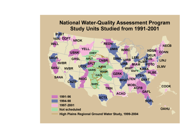
These data were released prior to the October 1, 2016 effective date for the USGS’s policy dictating the review, approval, and release of scientific data as referenced in USGS Survey Manual Chapter 502.8 Fundamental Science Practices: Review and Approval of Scientific Data for Release. This is a coverage of the boundaries and codes used for the U.S. Geological Survey's National Water-Quality Assessment (NAWQA) Program Study-Unit investigations in the conterminous United States, excluding the High Plains Regional Ground-Water Study. The data set represents the areas studied during the first decade of the NAWQA Program, from 1991-2001 ("cycle 1").
Categories: pre-SM502.8;
Tags: Aquifer system,
Conterminous United States,
Ground water,
NAWQA,
NSDI,

These data were released prior to the October 1, 2016 effective date for the USGS’s policy dictating the review, approval, and release of scientific data as referenced in USGS Survey Manual Chapter 502.8 Fundamental Science Practices: Review and Approval of Scientific Data for Release. The USGS compiles online access to water-resources data collected at approximately 1.5 million sites in all 50 States, the District of Columbia, Puerto Rico, the Virgin Islands, Guam, American Samoa and the Commonwealth of the Northern Mariana Islands.

These data were released prior to the October 1, 2016 effective date for the USGS’s policy dictating the review, approval, and release of scientific data as referenced in USGS Survey Manual Chapter 502.8 Fundamental Science Practices: Review and Approval of Scientific Data for Release. This digital dataset contains the name and location for the inflows to the surface-water network for the Central Valley Hydrologic Model (CVHM). The Central Valley encompasses an approximate 50,000-square-kilometer region of California. The complex hydrologic system of the Central Valley is simulated using the USGS numerical modeling code MODFLOW-FMP (Schmid and others, 2006b). This simulation is referred to here as the CVHM (Faunt,...
Categories: pre-SM502.8;
Tags: Alameda County,
Amador County,
Butte County,
CV-RASA,
Calaveras County,

These data were released prior to the October 1, 2016 effective date for the USGS’s policy dictating the review, approval, and release of scientific data as referenced in USGS Survey Manual Chapter 502.8 Fundamental Science Practices: Review and Approval of Scientific Data for Release. This digital dataset contains 61 sets of annual streamflow gains and losses between 1961 and 1977 along Central Valley surface-water network for the Central Valley Hydrologic Model (CVHM). The Central Valley encompasses an approximate 50,000 square-kilometer region of California. The complex hydrologic system of the Central Valley is simulated using the USGS's numerical modeling code MODFLOW-FMP (Schmid and others, 2006). This simulation...
Categories: pre-SM502.8;
Tags: Alameda County,
Amador County,
Butte County,
CV-RASA,
Calaveras County,

These data were released prior to the October 1, 2016 effective date for the USGS’s policy dictating the review, approval, and release of scientific data as referenced in USGS Survey Manual Chapter 502.8 Fundamental Science Practices: Review and Approval of Scientific Data for Release. This is a point coverage of dams in the United States and Puerto Rico, which originally was derived from the national inventory of dams data base (U.S. Army Corps of Engineers, 1982). The coverage includes locations of and selected characteristics of approximately 2,700 reservoirs and controlled natural lakes that have normal capacities of at least 5,000 acre-feet or maximum capacities of at least 25,000 acre-feet and that were completed...
Categories: pre-SM502.8;
Tags: Conterminous United States,
Dams,
NSDI,
Puerto Rico,
Reservoir capacity,

These data were released prior to the October 1, 2016 effective date for the USGS’s policy dictating the review, approval, and release of scientific data as referenced in USGS Survey Manual Chapter 502.8 Fundamental Science Practices: Review and Approval of Scientific Data for Release. This digital dataset contains the monthly diversions from the surface-water network for the Central Valley Hydrologic Model (CVHM). The Central Valley encompasses an approximate 50,000 square-kilometer region of California. The complex hydrologic system of the Central Valley is simulated using the USGS numerical modeling code MODFLOW-FMP (Schmid and others, 2006). This simulation is referred to here as the CVHM (Faunt, 2009). Utilizing...
Categories: pre-SM502.8;
Tags: Alameda County,
Amador County,
Butte County,
CV-RASA,
Calaveras County,
These data were released prior to the October 1, 2016 effective date for the USGS’s policy dictating the review, approval, and release of scientific data as referenced in USGS Survey Manual Chapter 502.8 Fundamental Science Practices: Review and Approval of Scientific Data for Release. As part of the U.S. Geological Survey's National Water-Quality Assessment Program, an investigation of the Yellowstone River Basin study unit is being conducted to document status and trends in surface- and ground-water quality. Surface-water samples are collected from streams or lakes at specific sampling stations. Efficient quantification of the site-specific geographic and environmental characteristics at sampling stations requires...
Categories: pre-SM502.8;
Tags: Montana,
NSDI,
North Dakota,
USGS Science Data Catalog (SDC),
Wyoming,

These data were released prior to the October 1, 2016 effective date for the USGS’s policy dictating the review, approval, and release of scientific data as referenced in USGS Survey Manual Chapter 502.8 Fundamental Science Practices: Review and Approval of Scientific Data for Release. This digital dataset contains the monthly inflows to the surface-water network for the Central Valley Hydrologic Model (CVHM). The Central Valley encompasses an approximate 50,000 square-kilometer region of California. The complex hydrologic system of the Central Valley is simulated using the USGS numerical modeling code MODFLOW-FMP (Schmid and others, 2006). This simulation is referred to here as the CVHM (Faunt, 2009). Utilizing...
Categories: pre-SM502.8;
Tags: Alameda County,
Amador County,
Butte County,
CV-RASA,
Calaveras County,
These data were released prior to the October 1, 2016 effective date for the USGS’s policy dictating the review, approval, and release of scientific data as referenced in USGS Survey Manual Chapter 502.8 Fundamental Science Practices: Review and Approval of Scientific Data for Release. This data set contains county estimates of nitrogen and phosphorus content of animal wastes produced annually for the years 1982, 1987, and 1992. The estimates are based on animal populations for those years from the 1992 Census of Agriculture (U.S. Bureau of the Census, 1995) and methods for estimating the nutrient content of manure from the Soil Conservation Service (1992). The data set includes several components.. 1. Spatial...
Categories: pre-SM502.8;
Tags: Ground water,
Manure,
NAWQA,
NSDI,
National Water-Quality Assessment Program,

These data were released prior to the October 1, 2016 effective date for the USGS’s policy dictating the review, approval, and release of scientific data as referenced in USGS Survey Manual Chapter 502.8 Fundamental Science Practices: Review and Approval of Scientific Data for Release. This digital dataset represents the area where lateral flow into and out of the Central Valley groundwater-flow system occurs. The General Head Boundary (GHB) is set to 0 and is only in the Delta and is specified in layer 1 where the groundwater system intersects the surface water system. The Central Valley encompasses an approximate 50,000 square-kilometer region of California. The complex hydrologic system of the Central Valley...
Categories: pre-SM502.8;
Tags: Alameda County,
Amador County,
Butte County,
CV-RASA,
Calaveras County,

These data were released prior to the October 1, 2016 effective date for the USGS’s policy dictating the review, approval, and release of scientific data as referenced in USGS Survey Manual Chapter 502.8 Fundamental Science Practices: Review and Approval of Scientific Data for Release. Digital surfaces and thicknesses of selected hydrogeologic units of the Floridan aquifer system were developed to define an updated hydrogeologic framework as part of the U.S. Geological Survey Groundwater Resources Program. This feature class contains lines representing the major groundwater divides in the Floridan aquifer system. The position of the divides was modified from Bush and Johnson, 1988, using the average Upper Floridan...
|

|
