Filters: Tags: nawqa (X) > Categories: pre-SM502.8 (X)
90 results (42ms)|
Filters
Date Range
Contacts
Tag Types Tag Schemes |

These data were released prior to the October 1, 2016 effective date for the USGS’s policy dictating the review, approval, and release of scientific data as referenced in USGS Survey Manual Chapter 502.8 Fundamental Science Practices: Review and Approval of Scientific Data for Release. This tabular data set represents the total amount of nitrogen and phosphorus, in kilograms for the year 2002, compiled for every MRB_E2RF1 catchment of the Major River Basins (MRBs, Crawford and others, 2006). The source data set is County-Level Estimates of Nutrient Inputs to the Land Surface of the Conterminous United States, 1982-2001 (Ruddy and others, 2006). The MRB_E2RF1 catchments are based on a modified version of the U.S....

These data were released prior to the October 1, 2016 effective date for the USGS’s policy dictating the review, approval, and release of scientific data as referenced in USGS Survey Manual Chapter 502.8 Fundamental Science Practices: Review and Approval of Scientific Data for Release. This data set represents estimated soil variables compiled for every catchment of NHDPlus for the conterminous United States. The variables included are cation exchange capacity, percent calcium carbonate, slope, water-table depth, soil thickness, hydrologic soil group, soil erodibility (k-factor), permeability, average water capacity, bulk density, percent organic material, percent clay, percent sand, and percent silt. The source...

These data were released prior to the October 1, 2016 effective date for the USGS’s policy dictating the review, approval, and release of scientific data as referenced in USGS Survey Manual Chapter 502.8 Fundamental Science Practices: Review and Approval of Scientific Data for Release. This data set represents the area of Hydrologic Landscape Regions (HLR) compiled for every catchment of NHDPlus for the conterminous United States. The source data set is a 100-meter version of Hydrologic Landscape Regions of the United States (Wolock, 2003). HLR groups watersheds on the basis of similarities in land-surface form, geologic texture, and climate characteristics. The NHDPlus Version 1.1 is an integrated suite of application-ready...

These data were released prior to the October 1, 2016 effective date for the USGS’s policy dictating the review, approval, and release of scientific data as referenced in USGS Survey Manual Chapter 502.8 Fundamental Science Practices: Review and Approval of Scientific Data for Release. A digital hydrologic network was developed to support SPAtially Referenced Regression on Watershed attributes (SPARROW) models within selected regions of the United States. These regions correspond with the U.S. Geological Survey's National Water Quality Assessment (NAWQA) Program Major River Basin (MRB) study units 2, 3, 4, 5, and 7 (Preston and others, 2009). MRB2, covers the South Atlantic-Gulf and Tennessee River basins. MRB3,...

These data were released prior to the October 1, 2016 effective date for the USGS’s policy dictating the review, approval, and release of scientific data as referenced in USGS Survey Manual Chapter 502.8 Fundamental Science Practices: Review and Approval of Scientific Data for Release. This 30-meter resolution data set represents the tree canopy layer for the conterminous United States for the 2001 time period. The data have been arranged into four tiles to facilitate timely display and manipulation within a Geographic Information System, browse graphic: nlcd01-partition.jpg. The National Land Cover Data Set for 2001 was produced through a cooperative project conducted by the Multi-Resolution Land Characteristics...

These data were released prior to the October 1, 2016 effective date for the USGS’s policy dictating the review, approval, and release of scientific data as referenced in USGS Survey Manual Chapter 502.8 Fundamental Science Practices: Review and Approval of Scientific Data for Release. This spatial data set was created by the U.S. Geological Survey (USGS) to represent the amount of atmospheric nitrogen deposition in the Pacific Northwest region of the United States (Hydro Region 17; Major River Basin 7 (MRB7)) during 2002 within each incremental watershed delineated in the NHDPlus v2 dataset.

Application of fertilizer phosphorus to nonfarm land in the United States Pacific Northwest for 2002
These data were released prior to the October 1, 2016 effective date for the USGS’s policy dictating the review, approval, and release of scientific data as referenced in USGS Survey Manual Chapter 502.8 Fundamental Science Practices: Review and Approval of Scientific Data for Release. This spatial data set was created by the U.S. Geological Survey (USGS) to represent the amount of fertilizer phosphorus that was applied to nonfarm land in the Pacific Northwest region of the United States (Hydro Region 17; Major River Basin 7 (MRB7)) during 2002.

These data were released prior to the October 1, 2016 effective date for the USGS’s policy dictating the review, approval, and release of scientific data as referenced in USGS Survey Manual Chapter 502.8 Fundamental Science Practices: Review and Approval of Scientific Data for Release. This spatial data set was created by the U.S. Geological Survey (USGS) to represent the amount of fertilizer nitrogen that was applied to farm land in the Pacific Northwest region of the United States (Hydro Region 17; Major River Basin 7 (MRB7)) during 2002.

These data were released prior to the October 1, 2016 effective date for the USGS’s policy dictating the review, approval, and release of scientific data as referenced in USGS Survey Manual Chapter 502.8 Fundamental Science Practices: Review and Approval of Scientific Data for Release. This is a vector GIS coverage (ESRI ArcInfo format) of the land use of the island of Oahu, 1998, derived from multiple sources of digital orthophotos.
Categories: pre-SM502.8;
Tags: Ford Island,
Geographic Information System,
Hawaii,
Mokauea Island,
Mokuoloe Island,

These data were released prior to the October 1, 2016 effective date for the USGS’s policy dictating the review, approval, and release of scientific data as referenced in USGS Survey Manual Chapter 502.8 Fundamental Science Practices: Review and Approval of Scientific Data for Release. A digital hydrologic network was developed to support SPAtially Referenced Regression on Watershed attributes (SPARROW) models within selected regions of the United States. These regions correspond with the U.S. Geological Survey's National Water Quality Assessment (NAWQA) Program Major River Basin (MRB) study units 2, 3, 4, 5, and 7 (Preston and others, 2009). MRB2, covers the South Atlantic-Gulf and Tennessee River basins. MRB3,...

These data were released prior to the October 1, 2016 effective date for the USGS’s policy dictating the review, approval, and release of scientific data as referenced in USGS Survey Manual Chapter 502.8 Fundamental Science Practices: Review and Approval of Scientific Data for Release. This 30-meter resolution raster data set of land cover for the conterminous United States ("NLCDep0905") was designed to describe conditions representative of the year 2000 and is the result of overlaying enhanced 1992 National Land Cover Data with 2000 population data at the block group geographic level. Any area (excluding water, developed land, or wetlands) with population density of at least 1,000 people per square mile was reclassified...
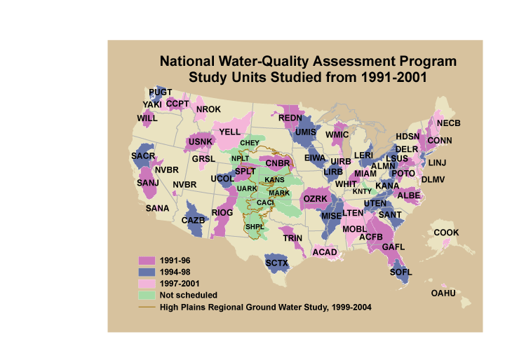
These data were released prior to the October 1, 2016 effective date for the USGS’s policy dictating the review, approval, and release of scientific data as referenced in USGS Survey Manual Chapter 502.8 Fundamental Science Practices: Review and Approval of Scientific Data for Release. This is a coverage of the boundaries and codes used for the U.S. Geological Survey's National Water-Quality Assessment (NAWQA) Program Study-Unit investigations in the conterminous United States, excluding the High Plains Regional Ground-Water Study. The data set represents the areas studied during the first decade of the NAWQA Program, from 1991-2001 ("cycle 1").
Categories: pre-SM502.8;
Tags: Aquifer system,
Conterminous United States,
Ground water,
NAWQA,
NSDI,
These data were released prior to the October 1, 2016 effective date for the USGS’s policy dictating the review, approval, and release of scientific data as referenced in USGS Survey Manual Chapter 502.8 Fundamental Science Practices: Review and Approval of Scientific Data for Release. This data set is a national map of predicted probability of nitrate contamination of shallow ground waters based on a logistic regression (LR) model. The LR model was used to predict the probability of nitrate contamination exceeding 4 mg/L in predominantly shallow, recently recharged ground waters of the United States. The model contains variables representing (1) nitrogen (N) fertilizer loading, (2) percent cropland-pasture, (3)...
These data were released prior to the October 1, 2016 effective date for the USGS’s policy dictating the review, approval, and release of scientific data as referenced in USGS Survey Manual Chapter 502.8 Fundamental Science Practices: Review and Approval of Scientific Data for Release. This dataset includes information for 200 pesticides on the average amount (pounds) applied to 87 agricultural crops and the acres of crops treated for counties within the conterminous United States. These data were derived by combining published state pesticide use coefficients published by the National Center for Food and Agricultural Policy (NCFAP) and county harvested crop acres available from the 1992 Census of Agriculture....
Categories: pre-SM502.8;
Tags: Census of Agriculture,
Conterminous United States,
NAWQA,
NSDI,
National Water Quality Assessment Program,

These data were released prior to the October 1, 2016 effective date for the USGS’s policy dictating the review, approval, and release of scientific data as referenced in USGS Survey Manual Chapter 502.8 Fundamental Science Practices: Review and Approval of Scientific Data for Release. This tabular dataset represents the estimated area of artificial drainage for the year 1992 and irrigation types for the year 1997 compiled for every catchment of NHDPlus for the conterminous United States. The source datasets were derived from tabular National Resource Inventory (NRI) datasets created by the National Resources Conservation Service (NRCS, U.S. Department of Agriculture, 1995, 1997). Artificial drainage is defined...

These data were released prior to the October 1, 2016 effective date for the USGS’s policy dictating the review, approval, and release of scientific data as referenced in USGS Survey Manual Chapter 502.8 Fundamental Science Practices: Review and Approval of Scientific Data for Release. This data set represents 1990 block group population density, in people per square kilometer, in the conterminous United States. This data set represents The data set was used as an input data layer for a national model to predict nitrate concentration in ground water used for drinking. Nolan and Hitt (2006) developed two national models to predict contamination of ground water by nonpoint sources of nitrate. The nonlinear approach...
Categories: pre-SM502.8;
Tags: Conterminous United States,
Drinking water,
Ground water,
Ground water contamination,
Ground water pollution,

These data were released prior to the October 1, 2016 effective date for the USGS’s policy dictating the review, approval, and release of scientific data as referenced in USGS Survey Manual Chapter 502.8 Fundamental Science Practices: Review and Approval of Scientific Data for Release. This data set represents the percent of cropland/pasture/fallow land cover in the conterminous United States. The data set was used as an input data layer for a national model to predict nitrate concentration in shallow ground water. Nolan and Hitt (2006) developed two national models to predict contamination of ground water by nonpoint sources of nitrate. The nonlinear approach to national-scale Ground-WAter Vulnerability Assessment...
Categories: pre-SM502.8;
Tags: Conterminous United States,
Cropland,
Fallow,
Ground water,
Ground water contamination,

These data were released prior to the October 1, 2016 effective date for the USGS’s policy dictating the review, approval, and release of scientific data as referenced in USGS Survey Manual Chapter 502.8 Fundamental Science Practices: Review and Approval of Scientific Data for Release. This data set represents the average annual nitrogen input from confined animal manure, 1992 and 1997, in kilograms per hectare, in the conterminous United States. The data set was used as an input data layer for a national model to predict nitrate concentration in shallow ground water. Nolan and Hitt (2006) developed two national models to predict contamination of ground water by nonpoint sources of nitrate. The nonlinear approach...

These data were released prior to the October 1, 2016 effective date for the USGS’s policy dictating the review, approval, and release of scientific data as referenced in USGS Survey Manual Chapter 502.8 Fundamental Science Practices: Review and Approval of Scientific Data for Release. This data set represents the area of National Resources Inventory surface drainage, field ditch conservation practice, in square kilometers, in the conterminous United States. The data set was used as an input data layer for a national model to predict nitrate concentration in ground water used for drinking. Nolan and Hitt (2006) developed two national models to predict contamination of ground water by nonpoint sources of nitrate....
Categories: pre-SM502.8;
Tags: Conterminous United States,
Drainage ditch,
Drinking water,
Ground water,
Ground water contamination,

These data were released prior to the October 1, 2016 effective date for the USGS’s policy dictating the review, approval, and release of scientific data as referenced in USGS Survey Manual Chapter 502.8 Fundamental Science Practices: Review and Approval of Scientific Data for Release. The enhanced National Land Cover Data 1992 ("NLCDe 92") served as the primary source for nationally consistent mapped land cover during the first decade of sampling for the National Water-Quality Assessment (NAWQA) Program of the U.S. Geological Survey (USGS). This 30-meter (30-m) resolution digital map was developed by overlaying USGS's original satellite imagery-based 1992 National Land Cover Data ("NLCD 92") with selected classifications...
|

|
