Filters: Date Range: {"choice":"week"} (X)
25,652 results (279ms)|
Filters
Date Types (for Date Range)
Types
Contacts
Categories
Tag Types
|
These data are daily summary checklists of all bird species observed at U.S. Geological Survey, Alaska Science Center (ASC) field camps in Interior Alaska. Version History: First release: May 2021 Revised: February 2022 (ver. 2.0) Revised: February 2023 (ver. 3.0)
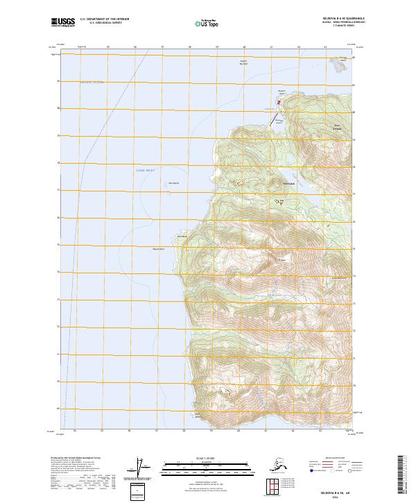
Layered geospatial PDF 7.5 Minute Quadrangle Map. Layers of geospatial data include orthoimagery, roads, grids, geographic names, elevation contours, hydrography, and other selected map features. This map is derived from GIS (geospatial information system) data. It represents a repackaging of GIS data in traditional map form, not creation of new information. The geospatial data in this map are from selected National Map data holdings and other government sources.
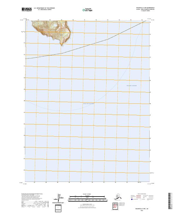
Layered geospatial PDF 7.5 Minute Quadrangle Map. Layers of geospatial data include orthoimagery, roads, grids, geographic names, elevation contours, hydrography, and other selected map features. This map is derived from GIS (geospatial information system) data. It represents a repackaging of GIS data in traditional map form, not creation of new information. The geospatial data in this map are from selected National Map data holdings and other government sources.
Panorama with images 846 and 847. C.M. & St. P. Railway cut, two miles northwest of Dedham, showing (north side): 1. Buff loess - 5-10 feet; 2. Gray loess with shells, calcium-carbonate concretions and iron oxide pipes - 5-8 feet; 3. Dense brown leached till (Kansan?) - 5-6 feet; 4. Buff calcareous till (Kansan?) - 45-50 feet; 5. Gray calcareous till (Kansan?) 0-10 feet (seams are filled with plates of selenite crystals). Newton Township, SW1/4, Sec. 7. Carroll County, Iowa. June 10, 1915.
The U.S. Geological Survey (USGS)’s Land Cover program has leveraged methodologies from legacy land cover projects - National Land Cover Database (NLCD) and Land Change Monitoring, Assessment, and Projection (LCMAP) - together with modern innovations in geospatial deep learning technologies to create the next generation of land cover and land change information. The product suite is called, “Annual NLCD” and includes six annual products that represent land cover and surface change characteristics of the U.S.: Land Cover Land Cover Change Land Cover Confidence Fractional Impervious Surface Impervious Descriptor Spectral Change Day of Year These land cover science algorithms harness the remotely sensed Landsat...
This data set describes nuclear microsatellite genotypes derived from six autosomal loci (AgCA222, Age7.1JT, BV13, BV20, NVH206, NVH195-2) in Cooper's Hawks. Samples originated from blood samples collected from live trapped birds. Version History: First release: December 2020 Revised: February 2022 (ver. 2.0)
Panoramic view from top of Needle Mountain over the Pinal Creek area of Gila conglomerate; to the right of photo 206 is seen the Schultze ranch, surrounded by granitic hills, behind which rise the higher summits of the Pinal Range. In the middle-ground Bloody Tanks Wash may be traced from ranch down to Miami Flats near the left of photo 207. Surrounding these flats and stretching far to south, into the drainage basin of the Gila River, are the low sculptured spurs of Gila conglomerate, rising highest on the right against the slopes of the Pinal Range. Gila County, Arizona. December 17, 1901. Plates 6-C and D (in reverse order) in U.S. Geological Survey, Professional paper 12. 1903
Categories: Image;
Tags: Arizona Professional Paper 12,
Gila County, Arizona,
Panoramic,
Photographers,
Ransome, F.L. Collection,
Nearer view in same general location as Ransome 770, showing constitution of a partly sandy variety: Yardstick for scale. Gila County, Arizona. 1911. Plate 22-B in U.S. Geological Survey. Professional paper 115. 1919.
Categories: Image;
Tags: Arizona Professional Paper 115,
Gila County, Arizona,
Photographers,
Ransome, F.L. Collection,
photo print
Dripping Spring Range, as seen from a point 2 miles east-southeast of Dripping Spring ranch; view is nearly west, note absence of regular forms compare with Ransome 757. Gila County, Arizona. 1911. Plate 4-B in U.S. Geological Survey. Professional paper 115. 1919.
Categories: Image;
Tags: Arizona Professional Paper 115,
Gila County, Arizona,
Photographers,
Ransome, F.L. Collection,
photo print
Fault between Naco limestone, on left, and Escabrosa limestone on right, crest of Ecabrosa Ridge west of Bisbee. The view is north, the canyon on the right being that extending from Bisbee up to Mule Pass. Cochise County, Arizona. November 28, 1902. Plate 20-A in U.S. Geological Survey. Professional paper 21. 1904.
Categories: Image;
Tags: Arizona Professional Paper 21,
Cochise County, Arizona,
Photographers,
Ransome, F.L. Collection,
photo print
View westward along the Abrigo fault. The ravine in the foreground is eroded along the fault. On the right are Escabrosa and Martin limestones; on the left Naco limestone, The distant saddle is also determined by the fault which has there brought Bolsa quartzite on the right against Naco limestone on the left. Cochise County, Arizona. November 25, 1902. Plate 17-B in U.S. Geological Survey. Professional paper 21. 1904.
Categories: Image;
Tags: Arizona Professional Paper 21,
Cochise County, Arizona,
Photographers,
Ransome, F.L. Collection,
photo print
In this dataset, there are eight text files that provide the raw fish behavior telemetry data and an excel sheet that provides the processed velocity data.
Categories: Data;
Tags: American shad,
Ecology,
Energy Resources,
USGS Science Data Catalog (SDC),
attraction,
This data package includes 2 child items with data from Pacific Black Brant (Branta bernicla nigricans) during winter and migration periods. Child Item 1: "Body mass, Morphological Measurements, Flock Counts, and Age-Ratios from Black Brant Overwintering in Three Lagoons Along the Baja California Peninsula, Mexico". The data include: (1) body mass and morphological measurements from sport hunter harvested brant, and (2) census counts of brant in Bahia de San Quintin, (3) counts for flock age ratio determination, and (4) behavior. Child Item 2: "Black Brant (Branta bernicla nigricans) Radio Detection and Migration Timing Alaska to Mexico". Data from brant tagged with VHF radio transmitters in July 1999 on the Yukon...
Categories: Data;
Tags: Alaska,
Animal populations,
Animals/Vertebrates,
Bahia San Quintín,
Baja California,

Lidar (Light detection and ranging) discrete-return point cloud data are available in the American Society for Photogrammetry and Remote Sensing (ASPRS) LAS format. The LAS format is a standardized binary format for storing 3-dimensional point cloud data and point attributes along with header information and variable length records specific to the data. Millions of data points are stored as a 3-dimensional data cloud as a series of x (longitude), y (latitude) and z (elevation) points. A few older projects in this collection are in ASCII format. Please refer to http://www.asprs.org/Committee-General/LASer-LAS-File-Format-Exchange-Activities.html for additional information. This data set is a LAZ (compressed LAS)...

Lidar (Light detection and ranging) discrete-return point cloud data are available in the American Society for Photogrammetry and Remote Sensing (ASPRS) LAS format. The LAS format is a standardized binary format for storing 3-dimensional point cloud data and point attributes along with header information and variable length records specific to the data. Millions of data points are stored as a 3-dimensional data cloud as a series of x (longitude), y (latitude) and z (elevation) points. A few older projects in this collection are in ASCII format. Please refer to http://www.asprs.org/Committee-General/LASer-LAS-File-Format-Exchange-Activities.html for additional information. This data set is a LAZ (compressed LAS)...

Lidar (Light detection and ranging) discrete-return point cloud data are available in the American Society for Photogrammetry and Remote Sensing (ASPRS) LAS format. The LAS format is a standardized binary format for storing 3-dimensional point cloud data and point attributes along with header information and variable length records specific to the data. Millions of data points are stored as a 3-dimensional data cloud as a series of x (longitude), y (latitude) and z (elevation) points. A few older projects in this collection are in ASCII format. Please refer to http://www.asprs.org/Committee-General/LASer-LAS-File-Format-Exchange-Activities.html for additional information. This data set is a LAZ (compressed LAS)...

Lidar (Light detection and ranging) discrete-return point cloud data are available in the American Society for Photogrammetry and Remote Sensing (ASPRS) LAS format. The LAS format is a standardized binary format for storing 3-dimensional point cloud data and point attributes along with header information and variable length records specific to the data. Millions of data points are stored as a 3-dimensional data cloud as a series of x (longitude), y (latitude) and z (elevation) points. A few older projects in this collection are in ASCII format. Please refer to http://www.asprs.org/Committee-General/LASer-LAS-File-Format-Exchange-Activities.html for additional information. This data set is a LAZ (compressed LAS)...

Lidar (Light detection and ranging) discrete-return point cloud data are available in the American Society for Photogrammetry and Remote Sensing (ASPRS) LAS format. The LAS format is a standardized binary format for storing 3-dimensional point cloud data and point attributes along with header information and variable length records specific to the data. Millions of data points are stored as a 3-dimensional data cloud as a series of x (longitude), y (latitude) and z (elevation) points. A few older projects in this collection are in ASCII format. Please refer to http://www.asprs.org/Committee-General/LASer-LAS-File-Format-Exchange-Activities.html for additional information. This data set is a LAZ (compressed LAS)...

Lidar (Light detection and ranging) discrete-return point cloud data are available in the American Society for Photogrammetry and Remote Sensing (ASPRS) LAS format. The LAS format is a standardized binary format for storing 3-dimensional point cloud data and point attributes along with header information and variable length records specific to the data. Millions of data points are stored as a 3-dimensional data cloud as a series of x (longitude), y (latitude) and z (elevation) points. A few older projects in this collection are in ASCII format. Please refer to http://www.asprs.org/Committee-General/LASer-LAS-File-Format-Exchange-Activities.html for additional information. This data set is a LAZ (compressed LAS)...
|

|
