Filters
Date Types (for Date Range)
Types
Contacts
Categories
Tag Types
Tag Schemes
|

The Watershed Boundary Dataset (WBD) is a comprehensive aggregated collection of hydrologic unit data consistent with the national criteria for delineation and resolution. It defines the areal extent of surface water drainage to a point except in coastal or lake front areas where there could be multiple outlets as stated by the "Federal Standards and Procedures for the National Watershed Boundary Dataset (WBD)" "Standard" (https://pubs.usgs.gov/tm/11/a3/). Watershed boundaries are determined solely upon science-based hydrologic principles, not favoring any administrative boundaries or special projects, nor particular program or agency. This dataset represents the hydrologic unit boundaries to the 12-digit (6th level)...
Tags: 10-digit,
12-digit,
14-digit,
16-digit,
2-digit, All tags...
4-digit,
6-digit,
8-digit,
AL,
Alabama,
Alcorn,
Anderson,
Ashe,
Avery,
Basin,
Bedford,
Bell,
Benton,
Bland,
Bledsoe,
Blount,
Bradley,
Bristol,
Buchanan,
Buncombe,
Caldwell,
Calloway,
Campbell,
Cannon,
Carroll,
Carter,
Catoosa,
Cherokee,
Chester,
Claiborne,
Clay,
Cocke,
Coffee,
Colbert,
Cullman,
Cumberland,
Dade,
DeKalb,
Decatur,
Dickenson,
Dickson,
Downloadable Data,
Esri Shapefile nan,
Etowah,
Fannin,
Fentress,
Franklin,
GA,
Georgia,
Giles,
Gilmer,
Graham,
Grainger,
Graves,
Grayson,
Greene,
Greenville,
Grundy,
HU-2,
HU-2 Region,
HU2_06,
HUC,
Habersham,
Hamblen,
Hamilton,
Hancock,
Hardin,
Harlan,
Hawkins,
Haywood,
Henderson,
Henry,
Hickman,
Houston,
Humphreys,
Hydrography,
Hydrologic Unit Code,
Hydrologic Units,
Itawamba,
Jackson,
Jefferson,
Johnson,
KY,
Kentucky,
Knox,
Lauderdale,
Lawrence,
Lee,
Letcher,
Lewis,
Limestone,
Lincoln,
Livingston,
Loudon,
Lumpkin,
Lyon,
MS,
Macon,
Madison,
Marion,
Marshall,
Maury,
McCracken,
McDowell,
McMinn,
McNairy,
Meigs,
Mississippi,
Mitchell,
Monroe,
Moore,
Morgan,
NC,
National Watershed Boundary Dataset (WBD),
National Watershed Boundary Dataset (WBD),
North Carolina,
Norton,
Perry,
Pickens,
Polk,
Prentiss,
Putnam,
Rabun,
Region,
Rhea,
Roane,
Russell,
Rutherford,
SC,
Scott,
Sequatchie,
Sevier,
Shapefile,
Smyth,
South Carolina,
Stewart,
Sub-basin,
Sub-region,
Subwatershed,
Sullivan,
Swain,
TN,
Tazewell,
Tennessee,
Tishomingo,
Towns,
Transylvania,
Trigg,
US,
Unicoi,
Union,
United States,
VA,
Van Buren,
Virginia,
WBD,
WV,
Walker,
Washington,
Watauga,
Watershed,
Watershed Boundary Dataset,
Wayne,
West Virginia,
White,
Whitfield,
Williamson,
Winston,
Wise,
Wythe,
Yancey,
inlandWaters, Fewer tags
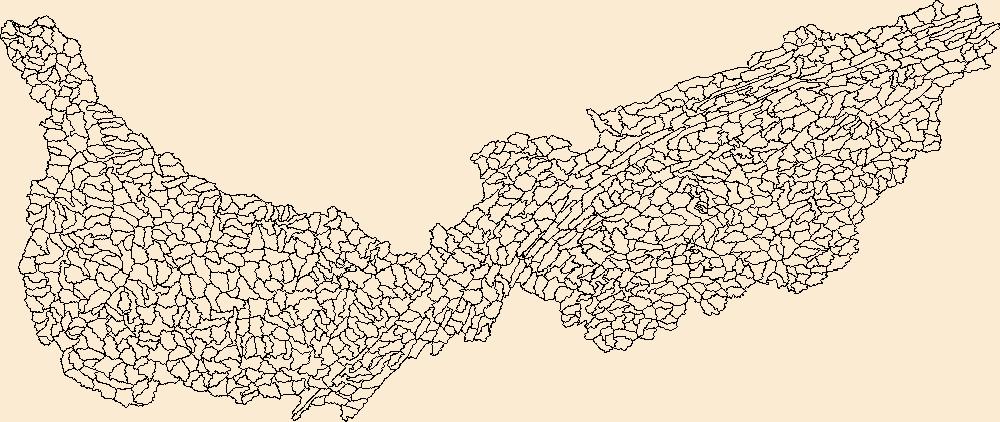
The Watershed Boundary Dataset (WBD) is a comprehensive aggregated collection of hydrologic unit data consistent with the national criteria for delineation and resolution. It defines the areal extent of surface water drainage to a point except in coastal or lake front areas where there could be multiple outlets as stated by the "Federal Standards and Procedures for the National Watershed Boundary Dataset (WBD)" "Standard" (https://pubs.usgs.gov/tm/11/a3/). Watershed boundaries are determined solely upon science-based hydrologic principles, not favoring any administrative boundaries or special projects, nor particular program or agency. This dataset represents the hydrologic unit boundaries to the 12-digit (6th level)...
Tags: 10-digit,
12-digit,
14-digit,
16-digit,
2-digit, All tags...
4-digit,
6-digit,
8-digit,
AL,
Alabama,
Alcorn,
Anderson,
Ashe,
Avery,
Basin,
Bedford,
Bell,
Benton,
Bland,
Bledsoe,
Blount,
Bradley,
Bristol,
Buchanan,
Buncombe,
Caldwell,
Calloway,
Campbell,
Cannon,
Carroll,
Carter,
Catoosa,
Cherokee,
Chester,
Claiborne,
Clay,
Cocke,
Coffee,
Colbert,
Cullman,
Cumberland,
Dade,
DeKalb,
Decatur,
Dickenson,
Dickson,
Downloadable Data,
Esri File GeoDatabase 10,
Etowah,
Fannin,
Fentress,
FileGDB,
Franklin,
GA,
Georgia,
Giles,
Gilmer,
Graham,
Grainger,
Graves,
Grayson,
Greene,
Greenville,
Grundy,
HU-2,
HU-2 Region,
HU2_06,
HUC,
Habersham,
Hamblen,
Hamilton,
Hancock,
Hardin,
Harlan,
Hawkins,
Haywood,
Henderson,
Henry,
Hickman,
Houston,
Humphreys,
Hydrography,
Hydrologic Unit Code,
Hydrologic Units,
Itawamba,
Jackson,
Jefferson,
Johnson,
KY,
Kentucky,
Knox,
Lauderdale,
Lawrence,
Lee,
Letcher,
Lewis,
Limestone,
Lincoln,
Livingston,
Loudon,
Lumpkin,
Lyon,
MS,
Macon,
Madison,
Marion,
Marshall,
Maury,
McCracken,
McDowell,
McMinn,
McNairy,
Meigs,
Mississippi,
Mitchell,
Monroe,
Moore,
Morgan,
NC,
National Watershed Boundary Dataset (WBD),
National Watershed Boundary Dataset (WBD),
North Carolina,
Norton,
Perry,
Pickens,
Polk,
Prentiss,
Putnam,
Rabun,
Region,
Rhea,
Roane,
Russell,
Rutherford,
SC,
Scott,
Sequatchie,
Sevier,
Smyth,
South Carolina,
Stewart,
Sub-basin,
Sub-region,
Subwatershed,
Sullivan,
Swain,
TN,
Tazewell,
Tennessee,
Tishomingo,
Towns,
Transylvania,
Trigg,
US,
Unicoi,
Union,
United States,
VA,
Van Buren,
Virginia,
WBD,
WV,
Walker,
Washington,
Watauga,
Watershed,
Watershed Boundary Dataset,
Wayne,
West Virginia,
White,
Whitfield,
Williamson,
Winston,
Wise,
Wythe,
Yancey,
inlandWaters, Fewer tags

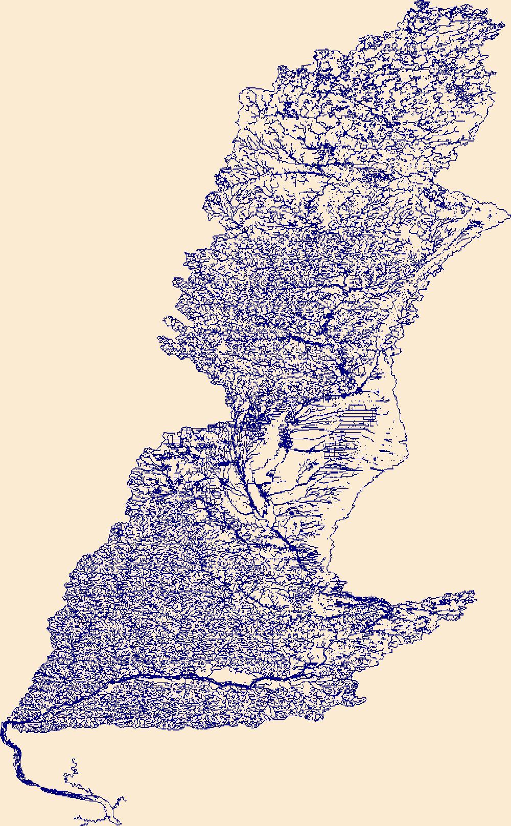
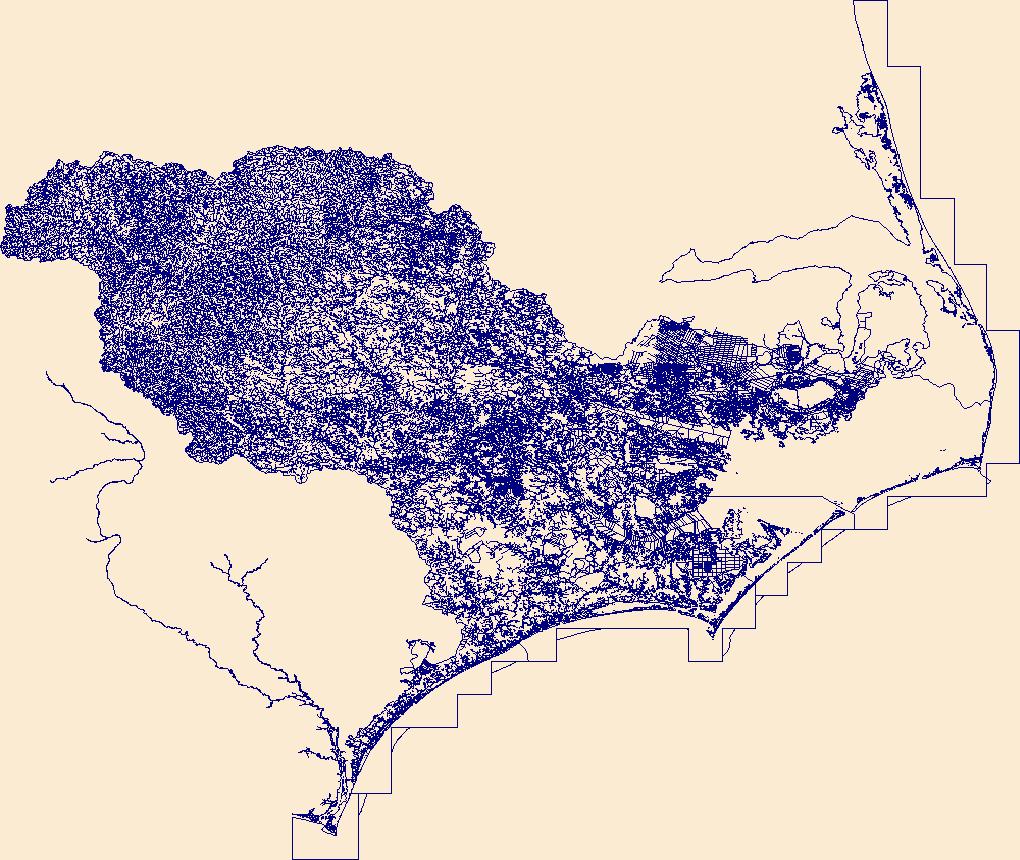
The High Resolution National Hydrography Dataset Plus (NHDPlus HR) is an integrated set of geospatial data layers, including the best available National Hydrography Dataset (NHD), the 10-meter 3D Elevation Program Digital Elevation Model (3DEP DEM), and the National Watershed Boundary Dataset (WBD). The NHDPlus HR combines the NHD, 3DEP DEMs, and WBD to create a stream network with linear referencing, feature naming, "value added attributes" (VAAs), elevation-derived catchments, and other features for hydrologic data analysis. The stream network with linear referencing is a system of data relationships applied to hydrographic systems so that one stream reach "flows" into another and "events" can be tied to and traced...
Tags: Adams County,
Adams County,
Asotin County,
Baker County,
Beaverhead County, All tags...
Benewah County,
Blaine County,
Boise County,
Camas County,
Clearwater County,
Columbia County,
Custer County,
Downloadable Data,
Elmore County,
FileGDB,
FileGDB 10.1,
Franklin County,
Garfield County,
Grant County,
HU-4 Subregion,
HU-4 Subregion,
HU4_1706,
Hydrography,
ID,
Idaho,
Idaho County,
Latah County,
Lemhi County,
Lewis County,
Lincoln County,
MT,
Mineral County,
Missoula County,
Montana,
NHDPlus HR Rasters,
NHDPlus High Resolution (NHDPlus HR),
National Hydrography Dataset (NHD),
National Hydrography Dataset Plus High Resolution (NHDPlus HR),
National Hydrography Dataset Plus High Resolution (NHDPlus HR) Current,
Nez Perce County,
OR,
Oregon,
Ravalli County,
Shoshone County,
Spokane County,
US,
Umatilla County,
Union County,
United States,
Valley County,
WA,
Walla Walla County,
Wallowa County,
Washington,
Whitman County,
base maps,
cartography,
catchments,
channels,
digital elevation models,
drainage basins,
earth sciences,
elevation,
environment,
geographic information systems,
geoscientific,
geospatial analysis,
hydrographic datasets,
hydrographic features,
hydrology,
imagery,
inland waters,
lakes,
land surface characteristics,
reservoirs,
river reaches,
rivers,
streamflow,
streamflow data,
streams,
topography,
water bodies,
water quality,
water resources,
watersheds, Fewer tags

The High Resolution National Hydrography Dataset Plus (NHDPlus HR) is an integrated set of geospatial data layers, including the best available National Hydrography Dataset (NHD), the 10-meter 3D Elevation Program Digital Elevation Model (3DEP DEM), and the National Watershed Boundary Dataset (WBD). The NHDPlus HR combines the NHD, 3DEP DEMs, and WBD to create a stream network with linear referencing, feature naming, "value added attributes" (VAAs), elevation-derived catchments, and other features for hydrologic data analysis. The stream network with linear referencing is a system of data relationships applied to hydrographic systems so that one stream reach "flows" into another and "events" can be tied to and traced...
Tags: Alcona County,
Alpena County,
Arenac County,
Bay County,
Cheboygan County, All tags...
Chippewa County,
Downloadable Data,
Emmet County,
FileGDB,
FileGDB 10.1,
HU-4 Subregion,
HU-4 Subregion,
HU4_0424,
Huron County,
Hydrography,
Iosco County,
MI,
Mackinac County,
Michigan,
NHDPlus HR Rasters,
NHDPlus High Resolution (NHDPlus HR),
National Hydrography Dataset (NHD),
National Hydrography Dataset Plus High Resolution (NHDPlus HR),
National Hydrography Dataset Plus High Resolution (NHDPlus HR) Current,
Presque Isle County,
Sanilac County,
St. Clair County,
Tuscola County,
US,
United States,
base maps,
cartography,
catchments,
channels,
digital elevation models,
drainage basins,
earth sciences,
elevation,
environment,
geographic information systems,
geoscientific,
geospatial analysis,
hydrographic datasets,
hydrographic features,
hydrology,
imagery,
inland waters,
lakes,
land surface characteristics,
reservoirs,
river reaches,
rivers,
streamflow,
streamflow data,
streams,
topography,
water bodies,
water quality,
water resources,
watersheds, Fewer tags

The High Resolution National Hydrography Dataset Plus (NHDPlus HR) is an integrated set of geospatial data layers, including the best available National Hydrography Dataset (NHD), the 10-meter 3D Elevation Program Digital Elevation Model (3DEP DEM), and the National Watershed Boundary Dataset (WBD). The NHDPlus HR combines the NHD, 3DEP DEMs, and WBD to create a stream network with linear referencing, feature naming, "value added attributes" (VAAs), elevation-derived catchments, and other features for hydrologic data analysis. The stream network with linear referencing is a system of data relationships applied to hydrographic systems so that one stream reach "flows" into another and "events" can be tied to and traced...
Tags: CA,
California,
Downloadable Data,
FileGDB,
FileGDB 10.1, All tags...
Fresno County,
HU-4 Subregion,
HU-4 Subregion,
HU4_1806,
Hydrography,
Kern County,
Kings County,
Merced County,
Monterey County,
NHDPlus HR Rasters,
NHDPlus High Resolution (NHDPlus HR),
National Hydrography Dataset (NHD),
National Hydrography Dataset Plus High Resolution (NHDPlus HR),
National Hydrography Dataset Plus High Resolution (NHDPlus HR) Current,
San Benito County,
San Luis Obispo County,
San Mateo County,
Santa Barbara County,
Santa Clara County,
Santa Cruz County,
Stanislaus County,
US,
United States,
Ventura County,
base maps,
cartography,
catchments,
channels,
digital elevation models,
drainage basins,
earth sciences,
elevation,
environment,
geographic information systems,
geoscientific,
geospatial analysis,
hydrographic datasets,
hydrographic features,
hydrology,
imagery,
inland waters,
lakes,
land surface characteristics,
reservoirs,
river reaches,
rivers,
streamflow,
streamflow data,
streams,
topography,
water bodies,
water quality,
water resources,
watersheds, Fewer tags

The High Resolution National Hydrography Dataset Plus (NHDPlus HR) is an integrated set of geospatial data layers, including the best available National Hydrography Dataset (NHD), the 10-meter 3D Elevation Program Digital Elevation Model (3DEP DEM), and the National Watershed Boundary Dataset (WBD). The NHDPlus HR combines the NHD, 3DEP DEMs, and WBD to create a stream network with linear referencing, feature naming, "value added attributes" (VAAs), elevation-derived catchments, and other features for hydrologic data analysis. The stream network with linear referencing is a system of data relationships applied to hydrographic systems so that one stream reach "flows" into another and "events" can be tied to and traced...
Tags: Downloadable Data,
FileGDB,
FileGDB 10.1,
HU-4 Subregion,
HU-4 Subregion, All tags...
HU4_2102,
Hydrography,
NHDPlus HR Rasters,
NHDPlus High Resolution (NHDPlus HR),
National Hydrography Dataset (NHD),
National Hydrography Dataset Plus High Resolution (NHDPlus HR),
National Hydrography Dataset Plus High Resolution (NHDPlus HR) Current,
St. Croix County,
St. John County,
St. Thomas County,
US,
United States,
United States Virgin Islands,
VI,
base maps,
cartography,
catchments,
channels,
digital elevation models,
drainage basins,
earth sciences,
elevation,
environment,
geographic information systems,
geoscientific,
geospatial analysis,
hydrographic datasets,
hydrographic features,
hydrology,
imagery,
inland waters,
lakes,
land surface characteristics,
reservoirs,
river reaches,
rivers,
streamflow,
streamflow data,
streams,
topography,
water bodies,
water quality,
water resources,
watersheds, Fewer tags

The High Resolution National Hydrography Dataset Plus (NHDPlus HR) is an integrated set of geospatial data layers, including the best available National Hydrography Dataset (NHD), the 10-meter 3D Elevation Program Digital Elevation Model (3DEP DEM), and the National Watershed Boundary Dataset (WBD). The NHDPlus HR combines the NHD, 3DEP DEMs, and WBD to create a stream network with linear referencing, feature naming, "value added attributes" (VAAs), elevation-derived catchments, and other features for hydrologic data analysis. The stream network with linear referencing is a system of data relationships applied to hydrographic systems so that one stream reach "flows" into another and "events" can be tied to and traced...
Tags: Downloadable Data,
FileGDB,
FileGDB 10.1,
HU-4 Subregion,
HU-4 Subregion, All tags...
HU4_0416,
Hydrography,
NHDPlus HR Rasters,
NHDPlus High Resolution (NHDPlus HR),
National Hydrography Dataset (NHD),
National Hydrography Dataset Plus High Resolution (NHDPlus HR),
National Hydrography Dataset Plus High Resolution (NHDPlus HR) Current,
US,
United States,
base maps,
cartography,
catchments,
channels,
digital elevation models,
drainage basins,
earth sciences,
elevation,
environment,
geographic information systems,
geoscientific,
geospatial analysis,
hydrographic datasets,
hydrographic features,
hydrology,
imagery,
inland waters,
lakes,
land surface characteristics,
reservoirs,
river reaches,
rivers,
streamflow,
streamflow data,
streams,
topography,
water bodies,
water quality,
water resources,
watersheds, Fewer tags

The High Resolution National Hydrography Dataset Plus (NHDPlus HR) is an integrated set of geospatial data layers, including the best available National Hydrography Dataset (NHD), the 10-meter 3D Elevation Program Digital Elevation Model (3DEP DEM), and the National Watershed Boundary Dataset (WBD). The NHDPlus HR combines the NHD, 3DEP DEMs, and WBD to create a stream network with linear referencing, feature naming, "value added attributes" (VAAs), elevation-derived catchments, and other features for hydrologic data analysis. The stream network with linear referencing is a system of data relationships applied to hydrographic systems so that one stream reach "flows" into another and "events" can be tied to and traced...
Tags: Ashtabula County,
Chautauqua County,
Cuyahoga County,
Downloadable Data,
Erie County, All tags...
Erie County,
Erie County,
FileGDB,
FileGDB 10.1,
HU-4 Subregion,
HU-4 Subregion,
HU4_0426i,
Hydrography,
Lake County,
Lorain County,
Lucas County,
MI,
Michigan,
Monroe County,
NHDPlus HR Rasters,
NHDPlus High Resolution (NHDPlus HR),
NY,
National Hydrography Dataset (NHD),
National Hydrography Dataset Plus High Resolution (NHDPlus HR),
National Hydrography Dataset Plus High Resolution (NHDPlus HR) Current,
New York,
OH,
Ohio,
Ottawa County,
PA,
Pennsylvania,
Sandusky County,
US,
United States,
Wayne County,
base maps,
cartography,
catchments,
channels,
digital elevation models,
drainage basins,
earth sciences,
elevation,
environment,
geographic information systems,
geoscientific,
geospatial analysis,
hydrographic datasets,
hydrographic features,
hydrology,
imagery,
inland waters,
lakes,
land surface characteristics,
reservoirs,
river reaches,
rivers,
streamflow,
streamflow data,
streams,
topography,
water bodies,
water quality,
water resources,
watersheds, Fewer tags

The High Resolution National Hydrography Dataset Plus (NHDPlus HR) is an integrated set of geospatial data layers, including the best available National Hydrography Dataset (NHD), the 10-meter 3D Elevation Program Digital Elevation Model (3DEP DEM), and the National Watershed Boundary Dataset (WBD). The NHDPlus HR combines the NHD, 3DEP DEMs, and WBD to create a stream network with linear referencing, feature naming, "value added attributes" (VAAs), elevation-derived catchments, and other features for hydrologic data analysis. The stream network with linear referencing is a system of data relationships applied to hydrographic systems so that one stream reach "flows" into another and "events" can be tied to and traced...
Tags: Anderson County,
Archer County,
Chambers County,
Clay County,
Collin County, All tags...
Cooke County,
Dallas County,
Denton County,
Downloadable Data,
Ellis County,
Fannin County,
FileGDB,
FileGDB 10.1,
Freestone County,
Grayson County,
Grimes County,
HU-4 Subregion,
HU-4 Subregion,
HU4_1203,
Hardin County,
Henderson County,
Hill County,
Hood County,
Houston County,
Hunt County,
Hydrography,
Jack County,
Johnson County,
Kaufman County,
Leon County,
Liberty County,
Limestone County,
Madison County,
Montague County,
NHDPlus HR Rasters,
NHDPlus High Resolution (NHDPlus HR),
National Hydrography Dataset (NHD),
National Hydrography Dataset Plus High Resolution (NHDPlus HR),
National Hydrography Dataset Plus High Resolution (NHDPlus HR) Current,
Navarro County,
Parker County,
Polk County,
Rockwall County,
San Jacinto County,
TX,
Tarrant County,
Texas,
Trinity County,
US,
United States,
Van Zandt County,
Walker County,
Wise County,
Young County,
base maps,
cartography,
catchments,
channels,
digital elevation models,
drainage basins,
earth sciences,
elevation,
environment,
geographic information systems,
geoscientific,
geospatial analysis,
hydrographic datasets,
hydrographic features,
hydrology,
imagery,
inland waters,
lakes,
land surface characteristics,
reservoirs,
river reaches,
rivers,
streamflow,
streamflow data,
streams,
topography,
water bodies,
water quality,
water resources,
watersheds, Fewer tags

The High Resolution National Hydrography Dataset Plus (NHDPlus HR) is an integrated set of geospatial data layers, including the best available National Hydrography Dataset (NHD), the 10-meter 3D Elevation Program Digital Elevation Model (3DEP DEM), and the National Watershed Boundary Dataset (WBD). The NHDPlus HR combines the NHD, 3DEP DEMs, and WBD to create a stream network with linear referencing, feature naming, "value added attributes" (VAAs), elevation-derived catchments, and other features for hydrologic data analysis. The stream network with linear referencing is a system of data relationships applied to hydrographic systems so that one stream reach "flows" into another and "events" can be tied to and traced...
Tags: Amite County,
Ascension County,
Assumption County,
Concordia County,
Downloadable Data, All tags...
East Baton Rouge County,
East Feliciana County,
FileGDB,
FileGDB 10.1,
Franklin County,
HU-4 Subregion,
HU-4 Subregion,
HU4_0807,
Hydrography,
Iberia County,
Iberville County,
LA,
Lincoln County,
Livingston County,
Louisiana,
MS,
Mississippi,
NHDPlus HR Rasters,
NHDPlus High Resolution (NHDPlus HR),
National Hydrography Dataset (NHD),
National Hydrography Dataset Plus High Resolution (NHDPlus HR),
National Hydrography Dataset Plus High Resolution (NHDPlus HR) Current,
Pike County,
Pointe Coupee County,
St. Charles County,
St. Helena County,
St. James County,
St. John the Baptist County,
St. Tammany County,
Tangipahoa County,
US,
United States,
West Baton Rouge County,
West Feliciana County,
Wilkinson County,
base maps,
cartography,
catchments,
channels,
digital elevation models,
drainage basins,
earth sciences,
elevation,
environment,
geographic information systems,
geoscientific,
geospatial analysis,
hydrographic datasets,
hydrographic features,
hydrology,
imagery,
inland waters,
lakes,
land surface characteristics,
reservoirs,
river reaches,
rivers,
streamflow,
streamflow data,
streams,
topography,
water bodies,
water quality,
water resources,
watersheds, Fewer tags

The High Resolution National Hydrography Dataset Plus (NHDPlus HR) is an integrated set of geospatial data layers, including the best available National Hydrography Dataset (NHD), the 10-meter 3D Elevation Program Digital Elevation Model (3DEP DEM), and the National Watershed Boundary Dataset (WBD). The NHDPlus HR combines the NHD, 3DEP DEMs, and WBD to create a stream network with linear referencing, feature naming, "value added attributes" (VAAs), elevation-derived catchments, and other features for hydrologic data analysis. The stream network with linear referencing is a system of data relationships applied to hydrographic systems so that one stream reach "flows" into another and "events" can be tied to and traced...
Tags: Alamosa County,
Baca County,
Bent County,
CO,
Chaffee County, All tags...
Cheyenne County,
Colfax County,
Colorado,
Costilla County,
Crowley County,
Custer County,
Douglas County,
Downloadable Data,
Eagle County,
El Paso County,
Elbert County,
FileGDB,
FileGDB 10.1,
Fremont County,
Greeley County,
Gunnison County,
HU-4 Subregion,
HU-4 Subregion,
HU4_1102,
Hamilton County,
Huerfano County,
Hydrography,
KS,
Kansas,
Kiowa County,
Kit Carson County,
Lake County,
Las Animas County,
Lincoln County,
NHDPlus HR Rasters,
NHDPlus High Resolution (NHDPlus HR),
NM,
National Hydrography Dataset (NHD),
National Hydrography Dataset Plus High Resolution (NHDPlus HR),
National Hydrography Dataset Plus High Resolution (NHDPlus HR) Current,
New Mexico,
Otero County,
Park County,
Pitkin County,
Prowers County,
Pueblo County,
Saguache County,
Summit County,
Teller County,
US,
Union County,
United States,
base maps,
cartography,
catchments,
channels,
digital elevation models,
drainage basins,
earth sciences,
elevation,
environment,
geographic information systems,
geoscientific,
geospatial analysis,
hydrographic datasets,
hydrographic features,
hydrology,
imagery,
inland waters,
lakes,
land surface characteristics,
reservoirs,
river reaches,
rivers,
streamflow,
streamflow data,
streams,
topography,
water bodies,
water quality,
water resources,
watersheds, Fewer tags

The High Resolution National Hydrography Dataset Plus (NHDPlus HR) is an integrated set of geospatial data layers, including the best available National Hydrography Dataset (NHD), the 10-meter 3D Elevation Program Digital Elevation Model (3DEP DEM), and the National Watershed Boundary Dataset (WBD). The NHDPlus HR combines the NHD, 3DEP DEMs, and WBD to create a stream network with linear referencing, feature naming, "value added attributes" (VAAs), elevation-derived catchments, and other features for hydrologic data analysis. The stream network with linear referencing is a system of data relationships applied to hydrographic systems so that one stream reach "flows" into another and "events" can be tied to and traced...
Tags: Bailey County,
Borden County,
Castro County,
Chaves County,
Cochran County, All tags...
Crosby County,
Curry County,
Dawson County,
Dickens County,
Downloadable Data,
FileGDB,
FileGDB 10.1,
Fisher County,
Floyd County,
Garza County,
HU-4 Subregion,
HU-4 Subregion,
HU4_1205,
Hale County,
Haskell County,
Hockley County,
Hydrography,
Jones County,
Kent County,
King County,
Lamb County,
Lubbock County,
Lynn County,
NHDPlus HR Rasters,
NHDPlus High Resolution (NHDPlus HR),
NM,
National Hydrography Dataset (NHD),
National Hydrography Dataset Plus High Resolution (NHDPlus HR),
National Hydrography Dataset Plus High Resolution (NHDPlus HR) Current,
New Mexico,
Parmer County,
Roosevelt County,
Scurry County,
Stonewall County,
Swisher County,
TX,
Terry County,
Texas,
US,
United States,
base maps,
cartography,
catchments,
channels,
digital elevation models,
drainage basins,
earth sciences,
elevation,
environment,
geographic information systems,
geoscientific,
geospatial analysis,
hydrographic datasets,
hydrographic features,
hydrology,
imagery,
inland waters,
lakes,
land surface characteristics,
reservoirs,
river reaches,
rivers,
streamflow,
streamflow data,
streams,
topography,
water bodies,
water quality,
water resources,
watersheds, Fewer tags
The High Resolution National Hydrography Dataset Plus (NHDPlus HR) is an integrated set of geospatial data layers, including the best available National Hydrography Dataset (NHD), the 10-meter 3D Elevation Program Digital Elevation Model (3DEP DEM), and the National Watershed Boundary Dataset (WBD). The NHDPlus HR combines the NHD, 3DEP DEMs, and WBD to create a stream network with linear referencing, feature naming, "value added attributes" (VAAs), elevation-derived catchments, and other features for hydrologic data analysis. The stream network with linear referencing is a system of data relationships applied to hydrographic systems so that one stream reach "flows" into another and "events" can be tied to and traced...
Tags: AdamsCounty,
ClarkCounty,
ColumbiaCounty,
CrawfordCounty,
DaneCounty, All tags...
Downloadable Data,
FileGDB,
FileGDB 10.1,
ForestCounty,
GogebicCounty,
GrantCounty,
HU-4 Subregion,
HU-4 Subregion,
Hydrography,
IowaCounty,
IronCounty,
JacksonCounty,
JuneauCounty,
LangladeCounty,
LincolnCounty,
MarathonCounty,
MarquetteCounty,
MonroeCounty,
NHDPlus HR Rasters,
NHDPlus High Resolution (NHDPlus HR),
National Hydrography Dataset (NHD),
National Hydrography Dataset Plus High Resolution (NHDPlus HR),
National Hydrography Dataset Plus High Resolution (NHDPlus HR) Current,
OneidaCounty,
PortageCounty,
PriceCounty,
RichlandCounty,
SaukCounty,
ShawanoCounty,
TaylorCounty,
US,
United States,
VernonCounty,
VilasCounty,
WI,
WausharaCounty,
Wisconsin,
WoodCounty,
base maps,
cartography,
catchments,
channels,
digital elevation models,
drainage basins,
earth sciences,
elevation,
environment,
geographic information systems,
geoscientific,
geospatial analysis,
hydrographic datasets,
hydrographic features,
hydrology,
imagery,
inland waters,
lakes,
land surface characteristics,
reservoirs,
river reaches,
rivers,
streamflow,
streamflow data,
streams,
topography,
water bodies,
water quality,
water resources,
watersheds, Fewer tags
The High Resolution National Hydrography Dataset Plus (NHDPlus HR) is an integrated set of geospatial data layers, including the best available National Hydrography Dataset (NHD), the 10-meter 3D Elevation Program Digital Elevation Model (3DEP DEM), and the National Watershed Boundary Dataset (WBD). The NHDPlus HR combines the NHD, 3DEP DEMs, and WBD to create a stream network with linear referencing, feature naming, "value added attributes" (VAAs), elevation-derived catchments, and other features for hydrologic data analysis. The stream network with linear referencing is a system of data relationships applied to hydrographic systems so that one stream reach "flows" into another and "events" can be tied to and traced...
Tags: BeaufortCounty,
BrunswickCounty,
CarteretCounty,
CravenCounty,
DareCounty, All tags...
Downloadable Data,
DuplinCounty,
DurhamCounty,
EdgecombeCounty,
FileGDB,
FileGDB 10.1,
FranklinCounty,
GranvilleCounty,
GreeneCounty,
HU-4 Subregion,
HU-4 Subregion,
HalifaxCounty,
HarnettCounty,
HydeCounty,
Hydrography,
JohnstonCounty,
JonesCounty,
LenoirCounty,
MartinCounty,
NC,
NHDPlus HR Rasters,
NHDPlus High Resolution (NHDPlus HR),
NashCounty,
National Hydrography Dataset (NHD),
National Hydrography Dataset Plus High Resolution (NHDPlus HR),
National Hydrography Dataset Plus High Resolution (NHDPlus HR) Current,
New HanoverCounty,
North Carolina,
OnslowCounty,
OrangeCounty,
PamlicoCounty,
PenderCounty,
PersonCounty,
PittCounty,
SampsonCounty,
TyrrellCounty,
US,
United States,
VanceCounty,
WakeCounty,
WarrenCounty,
WashingtonCounty,
WayneCounty,
WilsonCounty,
base maps,
cartography,
catchments,
channels,
digital elevation models,
drainage basins,
earth sciences,
elevation,
environment,
geographic information systems,
geoscientific,
geospatial analysis,
hydrographic datasets,
hydrographic features,
hydrology,
imagery,
inland waters,
lakes,
land surface characteristics,
reservoirs,
river reaches,
rivers,
streamflow,
streamflow data,
streams,
topography,
water bodies,
water quality,
water resources,
watersheds, Fewer tags
The High Resolution National Hydrography Dataset Plus (NHDPlus HR) is an integrated set of geospatial data layers, including the best available National Hydrography Dataset (NHD), the 10-meter 3D Elevation Program Digital Elevation Model (3DEP DEM), and the National Watershed Boundary Dataset (WBD). The NHDPlus HR combines the NHD, 3DEP DEMs, and WBD to create a stream network with linear referencing, feature naming, "value added attributes" (VAAs), elevation-derived catchments, and other features for hydrologic data analysis. The stream network with linear referencing is a system of data relationships applied to hydrographic systems so that one stream reach "flows" into another and "events" can be tied to and traced...
Tags: AK,
Alaska,
Bethel County,
Denali County,
Downloadable Data, All tags...
FileGDB,
FileGDB 10.1,
HU-8 Subbasin,
HU-8 Subbasin,
HU8_19020504,
Hydrography,
Kenai Peninsula County,
Matanuska-Susitna County,
NHDPlus HR Rasters,
NHDPlus High Resolution (NHDPlus HR),
National Hydrography Dataset (NHD),
National Hydrography Dataset Plus High Resolution (NHDPlus HR),
National Hydrography Dataset Plus High Resolution (NHDPlus HR) Current,
US,
United States,
Yukon-Koyukuk County,
base maps,
cartography,
catchments,
channels,
digital elevation models,
drainage basins,
earth sciences,
elevation,
environment,
geographic information systems,
geoscientific,
geospatial analysis,
hydrographic datasets,
hydrographic features,
hydrology,
imagery,
inland waters,
lakes,
land surface characteristics,
reservoirs,
river reaches,
rivers,
streamflow,
streamflow data,
streams,
topography,
water bodies,
water quality,
water resources,
watersheds, Fewer tags
The Watershed Boundary Dataset (WBD) is a comprehensive aggregated collection of hydrologic unit data consistent with the national criteria for delineation and resolution. It defines the areal extent of surface water drainage to a point except in coastal or lake front areas where there could be multiple outlets as stated by the "Federal Standards and Procedures for the National Watershed Boundary Dataset (WBD)" "Standard" (https://pubs.usgs.gov/tm/11/a3/). Watershed boundaries are determined solely upon science-based hydrologic principles, not favoring any administrative boundaries or special projects, nor particular program or agency. This dataset represents the hydrologic unit boundaries to the 12-digit (6th level)...
Tags: 10-digit,
12-digit,
14-digit,
16-digit,
2-digit, All tags...
4-digit,
6-digit,
8-digit,
Alpine,
Bannock,
Basin,
Bear Lake,
Beaver,
Box Elder,
CA,
Cache,
California,
Carbon,
Caribou,
Carson City,
Cassia,
Churchill,
Clark,
Davis,
Douglas,
Downloadable Data,
Duchesne,
El Dorado,
Elko,
Esmeralda,
Esri Shapefile nan,
Eureka,
Franklin,
Garfield,
HU-2,
HU-2 Region,
HU2_16,
HUC,
Harney,
Humboldt,
Hydrography,
Hydrologic Unit Code,
Hydrologic Units,
ID,
Idaho,
Inyo,
Iron,
Juab,
Kane,
Lander,
Lassen,
Lincoln,
Lyon,
Malheur,
Millard,
Mineral,
Mono,
Morgan,
NV,
National Watershed Boundary Dataset (WBD),
National Watershed Boundary Dataset (WBD),
Nevada,
Nevada,
Nye,
OR,
Oneida,
Oregon,
Pershing,
Piute,
Placer,
Power,
Region,
Rich,
Salt Lake,
San Bernardino,
Sanpete,
Sevier,
Shapefile,
Sierra,
Storey,
Sub-basin,
Sub-region,
Subwatershed,
Summit,
Tooele,
Tuolumne,
US,
UT,
Uinta,
United States,
Utah,
Utah,
WBD,
WY,
Wasatch,
Washington,
Washoe,
Watershed,
Watershed Boundary Dataset,
Wayne,
Weber,
White Pine,
Wyoming,
inlandWaters, Fewer tags
The Watershed Boundary Dataset (WBD) is a comprehensive aggregated collection of hydrologic unit data consistent with the national criteria for delineation and resolution. It defines the areal extent of surface water drainage to a point except in coastal or lake front areas where there could be multiple outlets as stated by the "Federal Standards and Procedures for the National Watershed Boundary Dataset (WBD)" "Standard" (https://pubs.usgs.gov/tm/11/a3/). Watershed boundaries are determined solely upon science-based hydrologic principles, not favoring any administrative boundaries or special projects, nor particular program or agency. This dataset represents the hydrologic unit boundaries to the 12-digit (6th level)...
Tags: 10-digit,
12-digit,
14-digit,
16-digit,
2-digit, All tags...
4-digit,
6-digit,
8-digit,
Alameda,
Alpine,
Amador,
Basin,
Butte,
CA,
Calaveras,
California,
Colusa,
Contra Costa,
Curry,
Del Norte,
Douglas,
Downloadable Data,
El Dorado,
Esmeralda,
Fresno,
GeoPackage,
Glenn,
HU-2,
HU-2 Region,
HU2_18,
HUC,
Humboldt,
Hydrography,
Hydrologic Unit Code,
Hydrologic Units,
Imperial,
Inyo,
Jackson,
Josephine,
Kern,
Kings,
Klamath,
Lake,
Lassen,
Los Angeles,
Madera,
Marin,
Mariposa,
Mendocino,
Merced,
Mineral,
Modoc,
Mono,
Monterey,
NV,
Napa,
National Watershed Boundary Dataset (WBD),
National Watershed Boundary Dataset (WBD),
Nevada,
Nevada,
Nye,
OR,
Open Geospatial Consortium GeoPackage 1.2,
Orange,
Oregon,
Placer,
Plumas,
Region,
Riverside,
Sacramento,
San Benito,
San Bernardino,
San Diego,
San Francisco,
San Joaquin,
San Luis Obispo,
San Mateo,
Santa Barbara,
Santa Clara,
Santa Cruz,
Shasta,
Sierra,
Siskiyou,
Solano,
Sonoma,
Stanislaus,
Sub-basin,
Sub-region,
Subwatershed,
Sutter,
Tehama,
Trinity,
Tulare,
Tuolumne,
US,
United States,
Ventura,
WBD,
Washoe,
Watershed,
Watershed Boundary Dataset,
Yolo,
Yuba,
inlandWaters, Fewer tags

The High Resolution National Hydrography Dataset Plus (NHDPlus HR) is an integrated set of geospatial data layers, including the best available National Hydrography Dataset (NHD), the 10-meter 3D Elevation Program Digital Elevation Model (3DEP DEM), and the National Watershed Boundary Dataset (WBD). The NHDPlus HR combines the NHD, 3DEP DEMs, and WBD to create a stream network with linear referencing, feature naming, "value added attributes" (VAAs), elevation-derived catchments, and other features for hydrologic data analysis. The stream network with linear referencing is a system of data relationships applied to hydrographic systems so that one stream reach "flows" into another and "events" can be tied to and traced...
Tags: AK,
Alaska,
Downloadable Data,
FileGDB,
FileGDB 10.1, All tags...
HU-8 Subbasin,
HU-8 Subbasin,
HU8_19020602,
Hydrography,
Kenai Peninsula County,
Kodiak Island County,
Lake and Peninsula County,
NHDPlus HR Rasters,
NHDPlus High Resolution (NHDPlus HR),
National Hydrography Dataset (NHD),
National Hydrography Dataset Plus High Resolution (NHDPlus HR),
National Hydrography Dataset Plus High Resolution (NHDPlus HR) Current,
US,
United States,
base maps,
cartography,
catchments,
channels,
digital elevation models,
drainage basins,
earth sciences,
elevation,
environment,
geographic information systems,
geoscientific,
geospatial analysis,
hydrographic datasets,
hydrographic features,
hydrology,
imagery,
inland waters,
lakes,
land surface characteristics,
reservoirs,
river reaches,
rivers,
streamflow,
streamflow data,
streams,
topography,
water bodies,
water quality,
water resources,
watersheds, Fewer tags

The High Resolution National Hydrography Dataset Plus (NHDPlus HR) is an integrated set of geospatial data layers, including the best available National Hydrography Dataset (NHD), the 10-meter 3D Elevation Program Digital Elevation Model (3DEP DEM), and the National Watershed Boundary Dataset (WBD). The NHDPlus HR combines the NHD, 3DEP DEMs, and WBD to create a stream network with linear referencing, feature naming, "value added attributes" (VAAs), elevation-derived catchments, and other features for hydrologic data analysis. The stream network with linear referencing is a system of data relationships applied to hydrographic systems so that one stream reach "flows" into another and "events" can be tied to and traced...
Tags: AR,
Arkansas,
Arkansas County,
Bolivar County,
Bollinger County, All tags...
Butler County,
Cape Girardeau County,
Clay County,
Coahoma County,
Craighead County,
Crittenden County,
Cross County,
DeSoto County,
Desha County,
Downloadable Data,
Dunklin County,
Faulkner County,
FileGDB,
FileGDB 10.1,
Greene County,
HU-4 Subregion,
HU-4 Subregion,
HU4_0802,
Hydrography,
Iron County,
Jackson County,
Jefferson County,
Lawrence County,
Lee County,
Lincoln County,
Lonoke County,
MO,
MS,
Madison County,
Mississippi,
Mississippi County,
Missouri,
Monroe County,
NHDPlus HR Rasters,
NHDPlus High Resolution (NHDPlus HR),
National Hydrography Dataset (NHD),
National Hydrography Dataset Plus High Resolution (NHDPlus HR),
National Hydrography Dataset Plus High Resolution (NHDPlus HR) Current,
New Madrid County,
Pemiscot County,
Phillips County,
Poinsett County,
Prairie County,
Pulaski County,
Randolph County,
Reynolds County,
Scott County,
St. Francis County,
St. Francois County,
Ste. Genevieve County,
Stoddard County,
Tunica County,
US,
United States,
Washington County,
Wayne County,
White County,
Woodruff County,
base maps,
cartography,
catchments,
channels,
digital elevation models,
drainage basins,
earth sciences,
elevation,
environment,
geographic information systems,
geoscientific,
geospatial analysis,
hydrographic datasets,
hydrographic features,
hydrology,
imagery,
inland waters,
lakes,
land surface characteristics,
reservoirs,
river reaches,
rivers,
streamflow,
streamflow data,
streams,
topography,
water bodies,
water quality,
water resources,
watersheds, Fewer tags

The High Resolution National Hydrography Dataset Plus (NHDPlus HR) is an integrated set of geospatial data layers, including the best available National Hydrography Dataset (NHD), the 10-meter 3D Elevation Program Digital Elevation Model (3DEP DEM), and the National Watershed Boundary Dataset (WBD). The NHDPlus HR combines the NHD, 3DEP DEMs, and WBD to create a stream network with linear referencing, feature naming, "value added attributes" (VAAs), elevation-derived catchments, and other features for hydrologic data analysis. The stream network with linear referencing is a system of data relationships applied to hydrographic systems so that one stream reach "flows" into another and "events" can be tied to and traced...
Tags: Aitkin County,
Ashland County,
Bayfield County,
Carlton County,
Cook County, All tags...
Douglas County,
Downloadable Data,
FileGDB,
FileGDB 10.1,
Gogebic County,
HU-4 Subregion,
HU-4 Subregion,
HU4_0401,
Hydrography,
Iron County,
Itasca County,
Lake County,
MI,
MN,
Michigan,
Minnesota,
NHDPlus HR Rasters,
NHDPlus High Resolution (NHDPlus HR),
National Hydrography Dataset (NHD),
National Hydrography Dataset Plus High Resolution (NHDPlus HR),
National Hydrography Dataset Plus High Resolution (NHDPlus HR) Current,
Pine County,
St. Louis County,
US,
United States,
WI,
Wisconsin,
base maps,
cartography,
catchments,
channels,
digital elevation models,
drainage basins,
earth sciences,
elevation,
environment,
geographic information systems,
geoscientific,
geospatial analysis,
hydrographic datasets,
hydrographic features,
hydrology,
imagery,
inland waters,
lakes,
land surface characteristics,
reservoirs,
river reaches,
rivers,
streamflow,
streamflow data,
streams,
topography,
water bodies,
water quality,
water resources,
watersheds, Fewer tags
|
|

