Filters: System Type: Data Release (X) > Categories: NOT Data Release - In Progress (X) > Date Range: {"choice":"month"} (X)
678 results (187ms)|
Filters
Date Types (for Date Range)
Types
Contacts
Categories
Tag Types
|
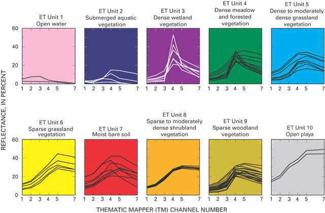
These data were released prior to the October 1, 2016 effective date for the USGS’s policy dictating the review, approval, and release of scientific data as referenced in USGS Survey Manual Chapter 502.8 Fundamental Science Practices: Review and Approval of Scientific Data for Release. The raster-based classification of evapotranspiration (ET) units is for nine major discharge areas in the Death Valley regional flow system. The ET units delineate general areas of similar vegetation and soil-moisture conditions. Classifications were derived from Landsat Thematic Mapper imagery data acquired June 13, 1992; Sept. 1, 1992; and June 21, 1989.
This data release includes 2 child items with tracking data for three large-bodied gull species and hybrids (Larus species) utilizing coastal areas of Alaska. Child Item 1: "Argos and GPS Satellite Tracking Data for Three Large-Bodied Gull Species and Hybrids (Larus spp.) - Processed Data" Quality-controlled data collected from Argos and Argos-linked GPS satellite transmitters. Child Item 2: "Argos and GPS Satellite Tracking Data for Three Large-Bodied Gull Species and Hybrids (Larus spp.) - Raw Data" All raw data collected from Argos and Argos-linked GPS satellite transmitters, provided for completeness of the archive. The "Processed Data" (Child Item 1) are better suited for most analytical purposes. Version...
Disclaimer: this is an historic version of NLCD provided for research and citation purposes. Different release dates of NLCD cannot be used with other release dates for correct analysis. Each release of NLCD generates a complete set of directly comparable products. These products must be used together for correct analysis. You can find the latest suite of synced products at www.mrlc.gov. The National Land Cover Database (NLCD) 1992 Land Cover layer was produced through a cooperative project conducted by the Multi-Resolution Land Characteristics (MRLC) Consortium. The MRLC Consortium is a partnership of federal agencies (www.mrlc.gov), consisting of the U.S. Geological Survey (USGS), the National Oceanic and Atmospheric...
The U.S. Geological Survey (USGS), in cooperation with the Washington State Department of Ecology (Ecology), conducted a study to describe the current understanding of the regional groundwater system of the lower Duwamish River valley and groundwater and surface-water interactions in the lower Duwamish Waterway. A nearshore site along the western shoreline of the Duwamish River, about 1.5 mi upstream from the river mouth, was selected for focused groundwater data collection by USGS. Data loggers were deployed in seven groundwater wells and one stilling well in the Duwamish River to measure specific conductance, temperature, and depth at 15-minute intervals for a period of about 2 years.This data release contains...

These data were released prior to the October 1, 2016 effective date for the USGS’s policy dictating the review, approval, and release of scientific data as referenced in USGS Survey Manual Chapter 502.8 Fundamental Science Practices: Review and Approval of Scientific Data for Release. This data release has been superseded by Deserts of the southwestern United States, for the Death Valley regional ground-water flow system study, Nevada and California (also available at https://doi.org/10.5066/p9frqbci) This digital data set defines the boundaries of the deserts of the southwestern United States. Those deserts include the Great Basin, Mojave, Colorado, and Sonoran Deserts as defined by Benson and Darrow (1981)....
This data release contains information on the seasonal diversity and abundance of arthropods collected at the Colville River Delta, Alaska, 2011-2012 and 2014-2107. Researchers with the US Geological Survey began studying the reproductive ecology of birds at a site on the Colville River near the Beaufort Sea coast in 2011. Researchers concurrently collected arthropods at 3-day intervals to understand the relationship between the seasonal abundance of arthropods and the reproductive output of insectivorous birds.
The Western Interior Plains aquifer system is located in parts of Arkansas, Colorado, Kansas, Missouri, Nebraska, New Mexico, Oklahoma, South Dakota, Texas, and Wyoming and covers an area of more than 220,800 square miles. The thickness of the aquifer system ranges from 500 feet in eastern Colorado (HA 730-D) to as much as 10,000 feet in western Oklahoma (PP_1414B). This aquifer system consists of water-bearing dolostone, limestone, and shale and overlies the basement confining unit in the western part of the Interior Plains physiographic division. This aquifer system consists of the upper aquifer unit (A1), a middle confining unit, and the lower aquifer unit (A2). The aquifer system is overlain by the Western Interior...
This data release includes 2 child items with tracking data for Black Scoters, a sea duck species that breeds throughout higher latitudes of Alaska and Canada and winters along coastal areas of North America. Child Item 1: "Argos Satellite Tracking Data for Black Scoters (Melanitta americana) - Processed Data" Quality-controlled data collected from Argos satellite transmitters. Child Item 2: "Argos Satellite Tracking Data for Black Scoters (Melanitta americana) - Raw Data" All raw data collected from Argos satellite transmitters, provided for completeness of the archive. The "Argos Processed Data" (Child Item 1) are better suited for most analytical purposes.
This Well Completion Report geospatial dataset represents an index to a subset of records available from the California Department of Water Resources' (DWR) Online System for Well Completion Reports (OSWCR). This version of the release contains data from about 262,649 well completion reports (WCRs) for water supply wells from Amador, Butte, Calaveras, Colusa, El Dorado, Glenn, Kern, Kings, Merced, Monterey, Nevada, Placer, Riverside, Sacramento, San Benito, San Bernardino, San Luis Obispo, San Joaquin, Santa Clara, Santa Cruz, Shasta, Stanislaus, Sutter, Tehama, Tulare, and Yuba counties in California. A subset of WCRs for 5969 wells that are not water supply wells also are included. The California Groundwater Ambient...
Tungsten is a mineral commodity critical for national security and the economy. Vein and greisen deposits host wolframite, a tungsten ore mineral that accounts for a significant portion of global mine production and resources. This data release contains updated resource information for globally distributed deposits that underpin grade and tonnage modeling efforts.
These data were released prior to the October 1, 2016 effective date for the USGS’s policy dictating the review, approval, and release of scientific data as referenced in USGS Survey Manual Chapter 502.8 Fundamental Science Practices: Review and Approval of Scientific Data for Release. Mineral resource areas are defined as those areas with a high likelihood of containing occurrences of valuable mineral deposits. A variety of sources of minerals information were consulted in compiling a digital map of mineral resource areas for metallic minerals in the Yellowstone River Basin. Source scales varied, but were no smaller than 1:500,000. The data are intended for river-basin level assessment and general analysis and...

These data were released prior to the October 1, 2016 effective date for the USGS’s policy dictating the review, approval, and release of scientific data as referenced in USGS Survey Manual Chapter 502.8 Fundamental Science Practices: Review and Approval of Scientific Data for Release. Digital surfaces and thicknesses of selected hydrogeologic units of the Floridan aquifer system were developed to define an updated hydrogeologic framework as part of the U.S. Geological Survey Groundwater Resources Program. This feature class contains data points used to generate est_10000_TDS raster. It also includes "control" points used to map the 10,000 boundary including time-domeain electromagnetic soundings, data source is...

These data were released prior to the October 1, 2016 effective date for the USGS’s policy dictating the review, approval, and release of scientific data as referenced in USGS Survey Manual Chapter 502.8 Fundamental Science Practices: Review and Approval of Scientific Data for Release. Digital surfaces and thicknesses of selected hydrogeologic units of the Floridan aquifer system were developed to define an updated hydrogeologic framework as part of the U.S. Geological Survey Groundwater Resources Program. This feature class contains data points used to generate the top of Floridan aquifer system raster. It also includes additional points used to constrain the surface to land surface.

These data were released prior to the October 1, 2016 effective date for the USGS’s policy dictating the review, approval, and release of scientific data as referenced in USGS Survey Manual Chapter 502.8 Fundamental Science Practices: Review and Approval of Scientific Data for Release. Digital surfaces and thicknesses of selected hydrogeologic units of the Floridan aquifer system were developed to define an updated hydrogeologic framework as part of the U.S. Geological Survey Groundwater Resources Program. This feature class contains contour lines generated from the base of FAS raster.

These data were released prior to the October 1, 2016 effective date for the USGS’s policy dictating the review, approval, and release of scientific data as referenced in USGS Survey Manual Chapter 502.8 Fundamental Science Practices: Review and Approval of Scientific Data for Release. Digital surfaces and thicknesses of selected hydrogeologic units of the Floridan aquifer system were developed to define an updated hydrogeologic framework as part of the U.S. Geological Survey Groundwater Resources Program. This feature class contains data points used to generate thickness of FAS raster.

These data were released prior to the October 1, 2016 effective date for the USGS’s policy dictating the review, approval, and release of scientific data as referenced in USGS Survey Manual Chapter 502.8 Fundamental Science Practices: Review and Approval of Scientific Data for Release. Digital surfaces and thicknesses of selected hydrogeologic units of the Floridan aquifer system were developed to define an updated hydrogeologic framework as part of the U.S. Geological Survey Groundwater Resources Program. This feature class contains data points used to generate the thickness of the regional Lower Floridan aquifer raster.

These data were released prior to the October 1, 2016 effective date for the USGS’s policy dictating the review, approval, and release of scientific data as referenced in USGS Survey Manual Chapter 502.8 Fundamental Science Practices: Review and Approval of Scientific Data for Release. Digital surfaces and thicknesses of selected hydrogeologic units of the Floridan aquifer system were developed to define an updated hydrogeologic framework as part of the U.S. Geological Survey Groundwater Resources Program. This feature class contains data points used to generate the glauconite marker unit raster.
USGS Geochron is a database of geochronological and thermochronological dates and data. The data set contains published ages, dates, analytical information, sample metadata including location, and source citations. The following analytical techniques are represented in the data set: 40Ar/39Ar, K-Ar, U-Th-Pb, Sm-Nd, Rb-Sr, Lu-Hf, fission track, luminescence, U-series, (U-Th)/He, Re-Os, 10Be and 26Al cosmogenic, and radiocarbon. This data set incorporates data previously hosted in the National Geochronological Database (Sloan and others, 2003), as well as data from published journal articles and ScienceBase data releases. These data are primarily from the United States, but data from other parts of the world are also...
Categories: Data;
Types: ArcGIS REST Map Service,
ArcGIS Service Definition,
Downloadable,
Map Service;
Tags: (U-Th)/He,
40Ar/39Ar,
Fission track,
Geochronology,
Geochronology,

The domain of the model is as follows: Row River from Dorena dam to the confluence with the Coast Fork; Coast Fork from Cottage Grove dam to the confluence with the Middle Fork; Silk Creek from River Mile 1.7 to the confluence with the Coast Fork. The basis for these features is the Willamette Flood Insurance Study – Phase One (2013). The hydraulics and hydrology for the FIS were reused in the production of these polygons; the reports and information associated with the FIS are applicable to this product. The Digital Elevation Model (DEM) utilized for the Willamette FIS submittal was produced by combining multiple overlapping topographic surveys for the Middle Fork and Coast Fork of the Willamette River. This DEM...
Mid-sized mammals (i.e., mesomammals) fulfill important ecological roles, serving as essential scavengers, predators, pollinators, and seed dispersers in the ecosystems they inhabit. Consequently, declines in mesomammal populations have the potential to disrupt ecological processes and degrade ecosystems. However, ecosystems characterized by high functional redundancy, where multiple species can fulfill similar ecological roles, may be less impacted by the loss of mesomammals and other vertebrates. The Greater Everglades Ecosystem in southern Florida is a historically biodiverse region that has recently been impacted by multiple anthropogenic threats, most notably the introduction of the Burmese python (Python bivittatus)....
Categories: Data,
Data Release - Revised;
Tags: Everglades,
Everglades National Park,
USGS Science Data Catalog (SDC),
biota,
invasive species,
|

|
