Filters: Tags: {"scheme":"The National Map Theme Thesaurus","name":"elevation"} (X) > partyWithName: U.S. Geological Survey (X)
13,203,282 results (4.1s)|
Filters
Date Range
Extensions Types Contacts
Categories Tag Types Tags (with Scheme=The National Map Theme Thesaurus) |

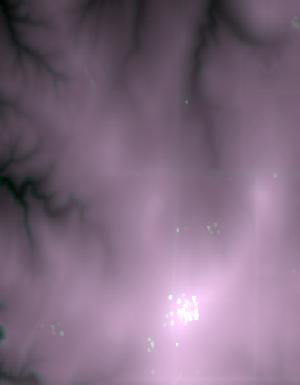
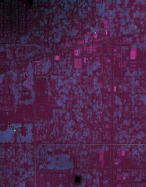
These data are orthorectified radar intensity images (ORI) derived from interferometric synthetic aperture radar (ifsar) data. An ORI is a high-resolution image derived from ifsar which has geometric distortions removed. Unlike optical imagery, ifsar can be collected in cloudy conditions. The USGS performs minimal quality assurance and no reprocessing of the ORI data. USGS distributes the ORI data as received from the contractors, partners or contributing entities.

These data are orthorectified radar intensity images (ORI) derived from interferometric synthetic aperture radar (ifsar) data. An ORI is a high-resolution image derived from ifsar which has geometric distortions removed. Unlike optical imagery, ifsar can be collected in cloudy conditions. The USGS performs minimal quality assurance and no reprocessing of the ORI data. USGS distributes the ORI data as received from the contractors, partners or contributing entities.

These data are orthorectified radar intensity images (ORI) derived from interferometric synthetic aperture radar (ifsar) data. An ORI is a high-resolution image derived from ifsar which has geometric distortions removed. Unlike optical imagery, ifsar can be collected in cloudy conditions. The USGS performs minimal quality assurance and no reprocessing of the ORI data. USGS distributes the ORI data as received from the contractors, partners or contributing entities.

These data are orthorectified radar intensity images (ORI) derived from interferometric synthetic aperture radar (ifsar) data. An ORI is a high-resolution image derived from ifsar which has geometric distortions removed. Unlike optical imagery, ifsar can be collected in cloudy conditions. The USGS performs minimal quality assurance and no reprocessing of the ORI data. USGS distributes the ORI data as received from the contractors, partners or contributing entities.

These data are orthorectified radar intensity images (ORI) derived from interferometric synthetic aperture radar (ifsar) data. An ORI is a high-resolution image derived from ifsar which has geometric distortions removed. Unlike optical imagery, ifsar can be collected in cloudy conditions. The USGS performs minimal quality assurance and no reprocessing of the ORI data. USGS distributes the ORI data as received from the contractors, partners or contributing entities.
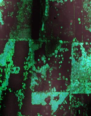
Lidar (Light detection and ranging) discrete-return point cloud data are available in the American Society for Photogrammetry and Remote Sensing (ASPRS) LAS format. The LAS format is a standardized binary format for storing 3-dimensional point cloud data and point attributes along with header information and variable length records specific to the data. Millions of data points are stored as a 3-dimensional data cloud as a series of x (longitude), y (latitude) and z (elevation) points. A few older projects in this collection are in ASCII format. Please refer to http://www.asprs.org/Committee-General/LASer-LAS-File-Format-Exchange-Activities.html for additional information. This data set is a LAZ (compressed LAS)...

These data are orthorectified radar intensity images (ORI) derived from interferometric synthetic aperture radar (ifsar) data. An ORI is a high-resolution image derived from ifsar which has geometric distortions removed. Unlike optical imagery, ifsar can be collected in cloudy conditions. The USGS performs minimal quality assurance and no reprocessing of the ORI data. USGS distributes the ORI data as received from the contractors, partners or contributing entities.
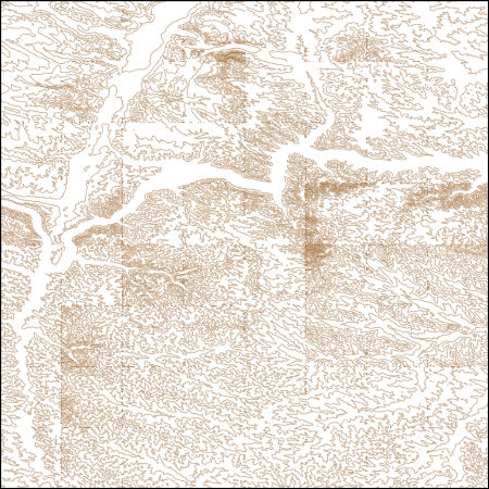
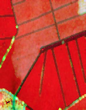
These vector contour lines are derived from the 3D Elevation Program using automated and semi-automated processes. They were created to support 1:24,000-scale CONUS and Hawaii, 1:25,000-scale Alaska, and 1:20,000-scale Puerto Rico / US Virgin Island topographic map products, but are also published in this GIS vector format. Contour intervals are assigned by 7.5-minute quadrangle, so this vector dataset is not visually seamless across quadrangle boundaries. The vector lines have elevation attributes (in feet above mean sea level on NAVD88), but this dataset does not carry line symbols or annotation.

Lidar (Light detection and ranging) discrete-return point cloud data are available in the American Society for Photogrammetry and Remote Sensing (ASPRS) LAS format. The LAS format is a standardized binary format for storing 3-dimensional point cloud data and point attributes along with header information and variable length records specific to the data. Millions of data points are stored as a 3-dimensional data cloud as a series of x (longitude), y (latitude) and z (elevation) points. A few older projects in this collection are in ASCII format. Please refer to http://www.asprs.org/Committee-General/LASer-LAS-File-Format-Exchange-Activities.html for additional information. This data set is a LAZ (compressed LAS)...
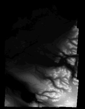
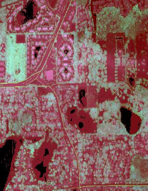
These data are Digital Surface Models (DSM) derived from interferometric synthetic aperture radar (ifsar) data. A DSM is a 3 dimensional representation of surface elevations in an area, including elevations of man-made structures and vegetation. The USGS performs minimal quality assurance and no reprocessing of the DSM data. USGS distributes the DSM data as received from the contractors, partners or contributing entities.
Types: Citation;
Tags: Cartography,
DSM,
Digital Mapping,
Digital Surface Model,
Digital Terrain Model,
Lidar (Light detection and ranging) discrete-return point cloud data are available in the American Society for Photogrammetry and Remote Sensing (ASPRS) LAS format. The LAS format is a standardized binary format for storing 3-dimensional point cloud data and point attributes along with header information and variable length records specific to the data. Millions of data points are stored as a 3-dimensional data cloud as a series of x (longitude), y (latitude) and z (elevation) points. A few older projects in this collection are in ASCII format. Please refer to http://www.asprs.org/Committee-General/LASer-LAS-File-Format-Exchange-Activities.html for additional information. This data set is a LAZ (compressed LAS)...

Lidar (Light detection and ranging) discrete-return point cloud data are available in the American Society for Photogrammetry and Remote Sensing (ASPRS) LAS format. The LAS format is a standardized binary format for storing 3-dimensional point cloud data and point attributes along with header information and variable length records specific to the data. Millions of data points are stored as a 3-dimensional data cloud as a series of x (longitude), y (latitude) and z (elevation) points. A few older projects in this collection are in ASCII format. Please refer to http://www.asprs.org/Committee-General/LASer-LAS-File-Format-Exchange-Activities.html for additional information. This data set is a LAZ (compressed LAS)...
Lidar (Light detection and ranging) discrete-return point cloud data are available in the American Society for Photogrammetry and Remote Sensing (ASPRS) LAS format. The LAS format is a standardized binary format for storing 3-dimensional point cloud data and point attributes along with header information and variable length records specific to the data. Millions of data points are stored as a 3-dimensional data cloud as a series of x (longitude), y (latitude) and z (elevation) points. A few older projects in this collection are in ASCII format. Please refer to http://www.asprs.org/Committee-General/LASer-LAS-File-Format-Exchange-Activities.html for additional information. This data set is a LAZ (compressed LAS)...
Lidar (Light detection and ranging) discrete-return point cloud data are available in the American Society for Photogrammetry and Remote Sensing (ASPRS) LAS format. The LAS format is a standardized binary format for storing 3-dimensional point cloud data and point attributes along with header information and variable length records specific to the data. Millions of data points are stored as a 3-dimensional data cloud as a series of x (longitude), y (latitude) and z (elevation) points. A few older projects in this collection are in ASCII format. Please refer to http://www.asprs.org/Committee-General/LASer-LAS-File-Format-Exchange-Activities.html for additional information. This data set is a LAZ (compressed LAS)...
Lidar (Light detection and ranging) discrete-return point cloud data are available in the American Society for Photogrammetry and Remote Sensing (ASPRS) LAS format. The LAS format is a standardized binary format for storing 3-dimensional point cloud data and point attributes along with header information and variable length records specific to the data. Millions of data points are stored as a 3-dimensional data cloud as a series of x (longitude), y (latitude) and z (elevation) points. A few older projects in this collection are in ASCII format. Please refer to http://www.asprs.org/Committee-General/LASer-LAS-File-Format-Exchange-Activities.html for additional information. This data set is a LAZ (compressed LAS)...

Lidar (Light detection and ranging) discrete-return point cloud data are available in the American Society for Photogrammetry and Remote Sensing (ASPRS) LAS format. The LAS format is a standardized binary format for storing 3-dimensional point cloud data and point attributes along with header information and variable length records specific to the data. Millions of data points are stored as a 3-dimensional data cloud as a series of x (longitude), y (latitude) and z (elevation) points. A few older projects in this collection are in ASCII format. Please refer to http://www.asprs.org/Committee-General/LASer-LAS-File-Format-Exchange-Activities.html for additional information. This data set is a LAZ (compressed LAS)...

Lidar (Light detection and ranging) discrete-return point cloud data are available in the American Society for Photogrammetry and Remote Sensing (ASPRS) LAS format. The LAS format is a standardized binary format for storing 3-dimensional point cloud data and point attributes along with header information and variable length records specific to the data. Millions of data points are stored as a 3-dimensional data cloud as a series of x (longitude), y (latitude) and z (elevation) points. A few older projects in this collection are in ASCII format. Please refer to http://www.asprs.org/Committee-General/LASer-LAS-File-Format-Exchange-Activities.html for additional information. This data set is a LAZ (compressed LAS)...
Lidar (Light detection and ranging) discrete-return point cloud data are available in the American Society for Photogrammetry and Remote Sensing (ASPRS) LAS format. The LAS format is a standardized binary format for storing 3-dimensional point cloud data and point attributes along with header information and variable length records specific to the data. Millions of data points are stored as a 3-dimensional data cloud as a series of x (longitude), y (latitude) and z (elevation) points. A few older projects in this collection are in ASCII format. Please refer to http://www.asprs.org/Committee-General/LASer-LAS-File-Format-Exchange-Activities.html for additional information. This data set is a LAZ (compressed LAS)...

Lidar (Light detection and ranging) discrete-return point cloud data are available in the American Society for Photogrammetry and Remote Sensing (ASPRS) LAS format. The LAS format is a standardized binary format for storing 3-dimensional point cloud data and point attributes along with header information and variable length records specific to the data. Millions of data points are stored as a 3-dimensional data cloud as a series of x (longitude), y (latitude) and z (elevation) points. A few older projects in this collection are in ASCII format. Please refer to http://www.asprs.org/Committee-General/LASer-LAS-File-Format-Exchange-Activities.html for additional information. This data set is a LAZ (compressed LAS)...
Lidar (Light detection and ranging) discrete-return point cloud data are available in the American Society for Photogrammetry and Remote Sensing (ASPRS) LAS format. The LAS format is a standardized binary format for storing 3-dimensional point cloud data and point attributes along with header information and variable length records specific to the data. Millions of data points are stored as a 3-dimensional data cloud as a series of x (longitude), y (latitude) and z (elevation) points. A few older projects in this collection are in ASCII format. Please refer to http://www.asprs.org/Committee-General/LASer-LAS-File-Format-Exchange-Activities.html for additional information. This data set is a LAZ (compressed LAS)...
|

|
