Filters: Tags: Earth sciences (X) > Date Range: {"choice":"year"} (X)
255 results (51ms)|
Filters
Date Types (for Date Range)
Types (Less)
Contacts (Less)
Categories (Less) Tag Types Tag Schemes
|

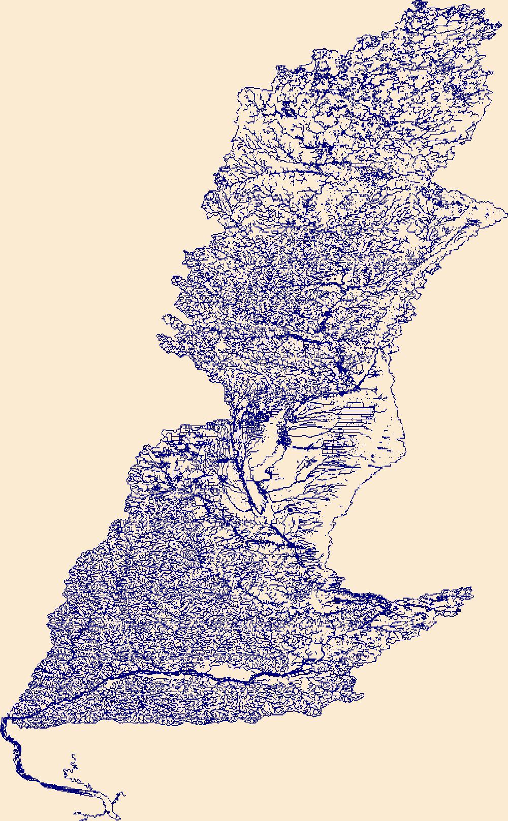
The High Resolution National Hydrography Dataset Plus (NHDPlus HR) is an integrated set of geospatial data layers, including the best available National Hydrography Dataset (NHD), the 10-meter 3D Elevation Program Digital Elevation Model (3DEP DEM), and the National Watershed Boundary Dataset (WBD). The NHDPlus HR combines the NHD, 3DEP DEMs, and WBD to create a stream network with linear referencing, feature naming, "value added attributes" (VAAs), elevation-derived catchments, and other features for hydrologic data analysis. The stream network with linear referencing is a system of data relationships applied to hydrographic systems so that one stream reach "flows" into another and "events" can be tied to and traced...

The High Resolution National Hydrography Dataset Plus (NHDPlus HR) is an integrated set of geospatial data layers, including the best available National Hydrography Dataset (NHD), the 10-meter 3D Elevation Program Digital Elevation Model (3DEP DEM), and the National Watershed Boundary Dataset (WBD). The NHDPlus HR combines the NHD, 3DEP DEMs, and WBD to create a stream network with linear referencing, feature naming, "value added attributes" (VAAs), elevation-derived catchments, and other features for hydrologic data analysis. The stream network with linear referencing is a system of data relationships applied to hydrographic systems so that one stream reach "flows" into another and "events" can be tied to and traced...

The High Resolution National Hydrography Dataset Plus (NHDPlus HR) is an integrated set of geospatial data layers, including the best available National Hydrography Dataset (NHD), the 10-meter 3D Elevation Program Digital Elevation Model (3DEP DEM), and the National Watershed Boundary Dataset (WBD). The NHDPlus HR combines the NHD, 3DEP DEMs, and WBD to create a stream network with linear referencing, feature naming, "value added attributes" (VAAs), elevation-derived catchments, and other features for hydrologic data analysis. The stream network with linear referencing is a system of data relationships applied to hydrographic systems so that one stream reach "flows" into another and "events" can be tied to and traced...

The High Resolution National Hydrography Dataset Plus (NHDPlus HR) is an integrated set of geospatial data layers, including the best available National Hydrography Dataset (NHD), the 10-meter 3D Elevation Program Digital Elevation Model (3DEP DEM), and the National Watershed Boundary Dataset (WBD). The NHDPlus HR combines the NHD, 3DEP DEMs, and WBD to create a stream network with linear referencing, feature naming, "value added attributes" (VAAs), elevation-derived catchments, and other features for hydrologic data analysis. The stream network with linear referencing is a system of data relationships applied to hydrographic systems so that one stream reach "flows" into another and "events" can be tied to and traced...

The High Resolution National Hydrography Dataset Plus (NHDPlus HR) is an integrated set of geospatial data layers, including the best available National Hydrography Dataset (NHD), the 10-meter 3D Elevation Program Digital Elevation Model (3DEP DEM), and the National Watershed Boundary Dataset (WBD). The NHDPlus HR combines the NHD, 3DEP DEMs, and WBD to create a stream network with linear referencing, feature naming, "value added attributes" (VAAs), elevation-derived catchments, and other features for hydrologic data analysis. The stream network with linear referencing is a system of data relationships applied to hydrographic systems so that one stream reach "flows" into another and "events" can be tied to and traced...
The High Resolution National Hydrography Dataset Plus (NHDPlus HR) is an integrated set of geospatial data layers, including the best available National Hydrography Dataset (NHD), the 10-meter 3D Elevation Program Digital Elevation Model (3DEP DEM), and the National Watershed Boundary Dataset (WBD). The NHDPlus HR combines the NHD, 3DEP DEMs, and WBD to create a stream network with linear referencing, feature naming, "value added attributes" (VAAs), elevation-derived catchments, and other features for hydrologic data analysis. The stream network with linear referencing is a system of data relationships applied to hydrographic systems so that one stream reach "flows" into another and "events" can be tied to and traced...
The High Resolution National Hydrography Dataset Plus (NHDPlus HR) is an integrated set of geospatial data layers, including the best available National Hydrography Dataset (NHD), the 10-meter 3D Elevation Program Digital Elevation Model (3DEP DEM), and the National Watershed Boundary Dataset (WBD). The NHDPlus HR combines the NHD, 3DEP DEMs, and WBD to create a stream network with linear referencing, feature naming, "value added attributes" (VAAs), elevation-derived catchments, and other features for hydrologic data analysis. The stream network with linear referencing is a system of data relationships applied to hydrographic systems so that one stream reach "flows" into another and "events" can be tied to and traced...
The High Resolution National Hydrography Dataset Plus (NHDPlus HR) is an integrated set of geospatial data layers, including the best available National Hydrography Dataset (NHD), the 10-meter 3D Elevation Program Digital Elevation Model (3DEP DEM), and the National Watershed Boundary Dataset (WBD). The NHDPlus HR combines the NHD, 3DEP DEMs, and WBD to create a stream network with linear referencing, feature naming, "value added attributes" (VAAs), elevation-derived catchments, and other features for hydrologic data analysis. The stream network with linear referencing is a system of data relationships applied to hydrographic systems so that one stream reach "flows" into another and "events" can be tied to and traced...
This data release provides flooding extent polygons based on sea-level rise and wave-driven total water levels for the coast of American Samoa's most populated islands of Tutuila, Ofu-Olosega, and Tau. Oceanographic, coastal engineering, ecologic, and geospatial data and tools were combined to evaluate the increased risks of storm-induced coastal flooding due to climate change and sea-level rise. We followed risk-based valuation approaches to map flooding due to waves and storm surge at 10-m2 resolution along these islands coastlines for annual (1-year), 20-year, and 100-year return-interval storm events and +0.25 m, +0.50 m, +1.00 m, +1.50 m, +2.00 m, and +3.00 m sea-level rise scenarios.
Categories: Data;
Tags: CMHRP,
Climate Change,
Coastal Processes,
Coastal and Marine Hazards and Resources Program,
Earth sciences,
The Coastal Storm Modeling System (CoSMoS) makes detailed predictions (meter-scale) over large geographic scales (100s of kilometers) of storm-induced coastal flooding and erosion for both current and future sea-level rise (SLR) scenarios. CoSMoS 3.2 for Northern California shows projections for future climate scenarios (sea-level rise and storms) to provide emergency responders and coastal planners with critical storm-hazards information that can be used to increase public safety, mitigate physical damages, and more effectively manage and allocate resources within complex coastal settings. Data for Northern California covers the coastline from Golden Gate Bridge to the California-Oregon state border.
Categories: Data;
Tags: Beaches,
CMHRP,
Climate Change,
Climatology,
ClimatologyMeteorologyAtmosphere,
Low altitude (300 meters above ground level (AGL)) digital aerial imagery acquired with a piloted fixed-wing aircraft was processed using Structure-from-Motion (SfM) photogrammetry techniques to produce high-resolution three-dimensional (3D) point clouds and digital elevation models (DEMs) and orthomosaic images. This dataset consists of DEMs produced from imagery collected along the Delaware Atlantic coast on June 11, 2022, to monitor coastal change. All horizontal data are provided in the Universal Transverse Mercator (UTM) projected coordinate system, Zone 18 North (18N), referenced to the North American Datum of 1983 (NAD83(2011)), and elevation is referenced to the North American Vertical Datum of 1988 (NAVD88),...
Low altitude (300 meters above ground level (AGL)) digital aerial imagery acquired with a piloted fixed-wing aircraft was processed using Structure-from-Motion (SfM) photogrammetry techniques to produce high-resolution three-dimensional (3D) point clouds and digital elevation models (DEMs) and orthomosaic images. This dataset consists of red-green-blue (RGB) orthomosaic images produced from imagery collected along the Delaware Atlantic coast on June 11, 2022, to monitor coastal change. All horizontal data are provided in the Universal Transverse Mercator (UTM) projected coordinate system, Zone 18 North (18N), referenced to the North American Datum of 1983 (NAD83(2011)).

The High Resolution National Hydrography Dataset Plus (NHDPlus HR) is an integrated set of geospatial data layers, including the best available National Hydrography Dataset (NHD), the 10-meter 3D Elevation Program Digital Elevation Model (3DEP DEM), and the National Watershed Boundary Dataset (WBD). The NHDPlus HR combines the NHD, 3DEP DEMs, and WBD to create a stream network with linear referencing, feature naming, "value added attributes" (VAAs), elevation-derived catchments, and other features for hydrologic data analysis. The stream network with linear referencing is a system of data relationships applied to hydrographic systems so that one stream reach "flows" into another and "events" can be tied to and traced...

The High Resolution National Hydrography Dataset Plus (NHDPlus HR) is an integrated set of geospatial data layers, including the best available National Hydrography Dataset (NHD), the 10-meter 3D Elevation Program Digital Elevation Model (3DEP DEM), and the National Watershed Boundary Dataset (WBD). The NHDPlus HR combines the NHD, 3DEP DEMs, and WBD to create a stream network with linear referencing, feature naming, "value added attributes" (VAAs), elevation-derived catchments, and other features for hydrologic data analysis. The stream network with linear referencing is a system of data relationships applied to hydrographic systems so that one stream reach "flows" into another and "events" can be tied to and traced...

The High Resolution National Hydrography Dataset Plus (NHDPlus HR) is an integrated set of geospatial data layers, including the best available National Hydrography Dataset (NHD), the 10-meter 3D Elevation Program Digital Elevation Model (3DEP DEM), and the National Watershed Boundary Dataset (WBD). The NHDPlus HR combines the NHD, 3DEP DEMs, and WBD to create a stream network with linear referencing, feature naming, "value added attributes" (VAAs), elevation-derived catchments, and other features for hydrologic data analysis. The stream network with linear referencing is a system of data relationships applied to hydrographic systems so that one stream reach "flows" into another and "events" can be tied to and traced...
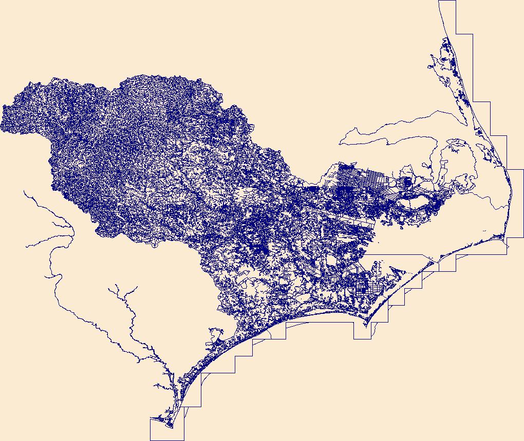
This dataset represents 505 campsites along the Colorado River in Grand Canyon with associated debris flow probabilities calculated for approximately a 100-year period (Griffiths and others, 2004) and geomorphic attributes mapped by the U.S. Geological Survey, Grand Canyon Monitoring and Research Center (USGS-GCMRC) (Hadley and others, 2018). The campsite polygons were developed as part of a master campsite database that was a collaborative effort to maintain between the National Park Service in Grand Canyon National Park and the USGS-GCMRC. Debris flow probabilities have been added as an attribute from ungauged tributary watersheds published in 2004 (Griffiths and others, 2004). Area and percentages of campsites...
Categories: Data,
Data Release - In Progress,
Data Release - Provisional;
Types: Downloadable,
Map Service,
OGC WFS Layer,
OGC WMS Layer,
Shapefile;
Tags: Arizona,
Colorado River,
Glen Canyon,
Glen Canyon National Recreation Area,
Grand Canyon,
This data release contains elemental concentration data from the reanalysis of 13,930 archived stream-sediment sample and associated stream sediment reference material and 968 archived rock samples and associated rock reference material. All archived material was from samples that were collected in Alaska. Samples were retrieved from the USGS Mineral Program's sample archive in Denver, CO. Sample processing consisted of splitting the appropriate aliquot for the requested analyses. Sample splitting was performed in the USGS Mineral Program's sample prep facilities. 13,800 samples were analyzed using a multi-element analytical method involving decomposition of the sample by sodium peroxide and elemental analysis by...
Categories: Data;
Tags: Alaska,
Alaska Range,
Aleutian Islands,
Aleutian Range,
Alexander Archipelago,
As part of a larger study examining stream conditions and the effect of Best Management Practices in the Chesapeake Bay watershed, thirty small streams on the Delmarva Peninsula were instrumented and monitored for gage height (water level), water temperature, and air temperature using Onset HOBO sensors from March to September 2022. In addition, two discrete discharge measurements were made at baseflow at each site. This data release contains four .csv files with time-series for gage height, water temperature, and air temperature for all thirty monitoring locations and a table of discrete discharge measurements and associated field measurement metadata: Delmarva_2022_Continuous_Air_Temperature.csv Delmarva_2022_Continuous_Gage_Height.csv...
This data release provides flooding extent polygons and flood depth rasters (geotiffs) based on sea-level rise and wave-driven total water levels for the coast of the most populated Hawaiian, Mariana, and American Samoan Islands. Oceanographic, coastal engineering, ecologic, and geospatial data and tools were combined to evaluate the increased risks of storm-induced coastal flooding due to climate change and sea-level rise. We followed risk-based valuation approaches to map flooding due to waves and storm surge at 10 square meter resolution along these islands’ coastlines for annual (1-year), 20-year, and 100-year return-interval storm events and +0.25 m, +0.50 m, +1.00 m, +1.50 m, +2.00 m, and +3.00 m sea-level...
Categories: Data;
Tags: CMHRP,
Climate Change,
Climatology,
Coastal Processes,
Coastal and Marine Hazards and Resources Program,
Sediment samples were collected from Los Padres reservoir in the Carmel River watershed, central California coast, between July 11 and 17, 2017, using a CME-45 barge-mounted drill rig, to characterize sedimentary properties in the reservoir deposits following the Soberanes Fire of 2016 and high river flows in winter 2017. Borehole samples were recovered using direct push coring with an Osterberg piston sampler operated by Taber Drilling Company of Sacramento, California, and overseen by AECOM, Inc. Sediment was recovered using a split-barrel sampler and a rotary drill bit was added to the sampler where needed to penetrate coarse sediment. Samples from four boreholes are described in this data release: three sampled...
Categories: Data;
Tags: CMHRP,
Carmel River,
Coastal and Marine Hazards and Resources Program,
Data Content Subjects,
Geomorphology,
|

|
