Filters
Date Range
Contacts
Tag Types
Tag Schemes
|
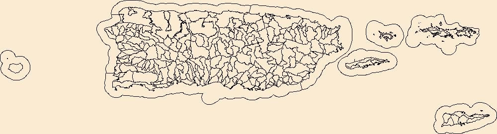
The Watershed Boundary Dataset (WBD) is a comprehensive aggregated collection of hydrologic unit data consistent with the national criteria for delineation and resolution. It defines the areal extent of surface water drainage to a point except in coastal or lake front areas where there could be multiple outlets as stated by the "Federal Standards and Procedures for the National Watershed Boundary Dataset (WBD)" "Standard" (https://pubs.usgs.gov/tm/11/a3/). Watershed boundaries are determined solely upon science-based hydrologic principles, not favoring any administrative boundaries or special projects, nor particular program or agency. This dataset represents the hydrologic unit boundaries to the 12-digit (6th level)...
Tags: 10-digit,
12-digit,
14-digit,
16-digit,
2-digit, All tags...
4-digit,
6-digit,
8-digit,
Adjuntas County,
Aguada County,
Aguadilla County,
Aguas Buenas County,
Aibonito County,
Arecibo County,
Arroyo County,
Añasco County,
Barceloneta County,
Barranquitas County,
Basin,
Bayamón County,
Cabo Rojo County,
Caguas County,
Camuy County,
Canóvanas County,
Carolina County,
Cataño County,
Cayey County,
Ceiba County,
Ciales County,
Cidra County,
Coamo County,
Comerío County,
Corozal County,
Culebra County,
Dorado County,
Downloadable Data,
Esri File GeoDatabase 10,
Fajardo County,
FileGDB,
Florida County,
Guayama County,
Guayanilla County,
Guaynabo County,
Gurabo County,
Guánica County,
HU-2,
HU-2 Region,
HU2_21,
HUC,
Hatillo County,
Hormigueros County,
Humacao County,
Hydrography,
Hydrologic Unit Code,
Hydrologic Units,
Isabela County,
Jayuya County,
Juana Díaz County,
Juncos County,
Lajas County,
Lares County,
Las Marías County,
Las Piedras County,
Loíza County,
Luquillo County,
Manatí County,
Maricao County,
Maunabo County,
Mayagüez County,
Moca County,
Morovis County,
Naguabo County,
Naranjito County,
National Watershed Boundary Dataset (WBD),
National Watershed Boundary Dataset (WBD),
Orocovis County,
PR,
Patillas County,
Peñuelas County,
Ponce County,
Puerto Rico,
Quebradillas County,
Region,
Rincón County,
Río Grande County,
Sabana Grande County,
Salinas County,
San Germán County,
San Juan County,
San Lorenzo County,
San Sebastián County,
Santa Isabel County,
St. Croix County,
St. John County,
St. Thomas County,
Sub-basin,
Sub-region,
Subwatershed,
Toa Alta County,
Toa Baja County,
Trujillo Alto County,
US,
United States,
Utuado County,
VI,
Vega Alta County,
Vega Baja County,
Vieques County,
Villalba County,
Virgin Islands,
WBD,
Watershed,
Watershed Boundary Dataset,
Yabucoa County,
Yauco County,
inlandWaters, Fewer tags

The Watershed Boundary Dataset (WBD) is a comprehensive aggregated collection of hydrologic unit data consistent with the national criteria for delineation and resolution. It defines the areal extent of surface water drainage to a point except in coastal or lake front areas where there could be multiple outlets as stated by the "Federal Standards and Procedures for the National Watershed Boundary Dataset (WBD)" "Standard" (https://pubs.usgs.gov/tm/11/a3/). Watershed boundaries are determined solely upon science-based hydrologic principles, not favoring any administrative boundaries or special projects, nor particular program or agency. This dataset represents the hydrologic unit boundaries to the 12-digit (6th level)...
Tags: 10-digit,
12-digit,
14-digit,
16-digit,
2-digit, All tags...
4-digit,
6-digit,
8-digit,
Adjuntas County,
Aguada County,
Aguadilla County,
Aguas Buenas County,
Aibonito County,
Arecibo County,
Arroyo County,
Añasco County,
Barceloneta County,
Barranquitas County,
Basin,
Bayamón County,
Cabo Rojo County,
Caguas County,
Camuy County,
Canóvanas County,
Carolina County,
Cataño County,
Cayey County,
Ceiba County,
Ciales County,
Cidra County,
Coamo County,
Comerío County,
Corozal County,
Culebra County,
Dorado County,
Downloadable Data,
Esri Shapefile,
Fajardo County,
Florida County,
Guayama County,
Guayanilla County,
Guaynabo County,
Gurabo County,
Guánica County,
HU-2,
HU-2 Region,
HU2_21,
HUC,
Hatillo County,
Hormigueros County,
Humacao County,
Hydrography,
Hydrologic Unit Code,
Hydrologic Units,
Isabela County,
Jayuya County,
Juana Díaz County,
Juncos County,
Lajas County,
Lares County,
Las Marías County,
Las Piedras County,
Loíza County,
Luquillo County,
Manatí County,
Maricao County,
Maunabo County,
Mayagüez County,
Moca County,
Morovis County,
Naguabo County,
Naranjito County,
National Watershed Boundary Dataset (WBD),
National Watershed Boundary Dataset (WBD),
Orocovis County,
PR,
Patillas County,
Peñuelas County,
Ponce County,
Puerto Rico,
Quebradillas County,
Region,
Rincón County,
Río Grande County,
Sabana Grande County,
Salinas County,
San Germán County,
San Juan County,
San Lorenzo County,
San Sebastián County,
Santa Isabel County,
Shapefile,
St. Croix County,
St. John County,
St. Thomas County,
Sub-basin,
Sub-region,
Subwatershed,
Toa Alta County,
Toa Baja County,
Trujillo Alto County,
US,
United States,
Utuado County,
VI,
Vega Alta County,
Vega Baja County,
Vieques County,
Villalba County,
Virgin Islands,
WBD,
Watershed,
Watershed Boundary Dataset,
Yabucoa County,
Yauco County,
inlandWaters, Fewer tags

The Watershed Boundary Dataset (WBD) is a comprehensive aggregated collection of hydrologic unit data consistent with the national criteria for delineation and resolution. It defines the areal extent of surface water drainage to a point except in coastal or lake front areas where there could be multiple outlets as stated by the "Federal Standards and Procedures for the National Watershed Boundary Dataset (WBD)" "Standard" (https://pubs.usgs.gov/tm/11/a3/). Watershed boundaries are determined solely upon science-based hydrologic principles, not favoring any administrative boundaries or special projects, nor particular program or agency. This dataset represents the hydrologic unit boundaries to the 12-digit (6th level)...
Tags: 10-digit,
12-digit,
14-digit,
16-digit,
2-digit, All tags...
4-digit,
6-digit,
8-digit,
Adjuntas County,
Aguada County,
Aguadilla County,
Aguas Buenas County,
Aibonito County,
Arecibo County,
Arroyo County,
Añasco County,
Barceloneta County,
Barranquitas County,
Basin,
Bayamón County,
Cabo Rojo County,
Caguas County,
Camuy County,
Canóvanas County,
Carolina County,
Cataño County,
Cayey County,
Ceiba County,
Ciales County,
Cidra County,
Coamo County,
Comerío County,
Corozal County,
Culebra County,
Dorado County,
Downloadable Data,
Fajardo County,
Florida County,
GeoPackage,
Guayama County,
Guayanilla County,
Guaynabo County,
Gurabo County,
Guánica County,
HU-2,
HU-2 Region,
HU2_21,
HUC,
Hatillo County,
Hormigueros County,
Humacao County,
Hydrography,
Hydrologic Unit Code,
Hydrologic Units,
Isabela County,
Jayuya County,
Juana Díaz County,
Juncos County,
Lajas County,
Lares County,
Las Marías County,
Las Piedras County,
Loíza County,
Luquillo County,
Manatí County,
Maricao County,
Maunabo County,
Mayagüez County,
Moca County,
Morovis County,
Naguabo County,
Naranjito County,
National Watershed Boundary Dataset (WBD),
National Watershed Boundary Dataset (WBD),
Open Geospatial Consortium GeoPackage 1.2,
Orocovis County,
PR,
Patillas County,
Peñuelas County,
Ponce County,
Puerto Rico,
Quebradillas County,
Region,
Rincón County,
Río Grande County,
Sabana Grande County,
Salinas County,
San Germán County,
San Juan County,
San Lorenzo County,
San Sebastián County,
Santa Isabel County,
St. Croix County,
St. John County,
St. Thomas County,
Sub-basin,
Sub-region,
Subwatershed,
Toa Alta County,
Toa Baja County,
Trujillo Alto County,
US,
United States,
Utuado County,
VI,
Vega Alta County,
Vega Baja County,
Vieques County,
Villalba County,
Virgin Islands,
WBD,
Watershed,
Watershed Boundary Dataset,
Yabucoa County,
Yauco County,
inlandWaters, Fewer tags
|
|

