Filters: Tags: NFHP Cooperator (X)
44 results (168ms)|
Filters
Date Range
Extensions Types
Contacts
Categories Tag Types
|
This shapefile is the official focus area of the Pacific Marine and Estuarine Fish Habitat Partnership (PMEP), a recognized Fish Habitat Partnership (FHP) of the National Fish Habitat Partnership (NFHP). The focus area lays within the partnership's larger area of interest or 'geographic scope' within and offshore of the states of California, Oregon, and Washington. The focus area boundary aims to highlight the nearshore marine and estuarine tidal waters.
Categories: Data;
Types: ArcGIS REST Map Service,
ArcGIS Service Definition,
Downloadable,
Map Service;
Tags: Analytical boundary,
Aquatic habitats,
Boundaries,
California,
FHP Boundary,
This CSV file contains landscape factors representing anthropogenic disturbances to stream habitats summarized within 6th level Hydrologic Unit Code (HUC12) watersheds of the Watershed Boundary Dataset. The source datasets compiled and attributed to spatial units were identified as being: (1) meaningful for assessing fluvial fish habitat; (2) consistent across the entire study area in the way that they were assembled; (3) broadly representative of conditions in the past 10 years, and (4) of sufficient spatial resolution that they could be used to make valid comparisons among local catchment units. Variables summarized at the HUC12 scale include measures of anthropogenic land uses, population density, roads, dams,...
Categories: Data;
Types: ArcGIS REST Map Service,
ArcGIS Service Definition,
Downloadable,
Map Service;
Tags: 2015 National Assessment,
2015 National Assessment,
Alaska,
Anthropogenic factors,
DataProduct,
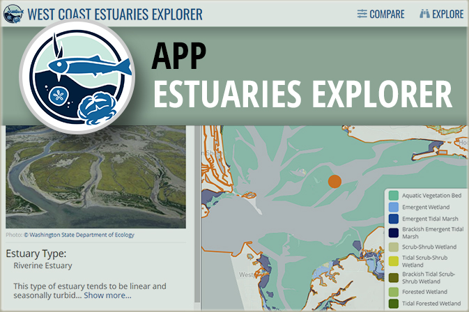
This application enables you to compare estuaries to each other along the coastlines of Washington, Oregon, and California. You can combine dynamic filters and an interactive map to find specific estuary types you are interested in, such as large river delta estuaries which often have extensive diking; small, riverine estuaries that are at the lowest risk to fish habitat degradation; or estuaries contain species that interest you. Only want to compare estuaries in a specific area? Simply zoom the map in to that area, and the filters automatically update to show you the number of estuaries in that area that meet different conditions. You can also explore estuaries in more detail to find a specific estuary by name...
This map service layer provides information for projects funded by the 20 regional fish habitat partnerships through the National Fish Habitat funds. Projects funded since 2006 are represented in the service layer and the data are expected to be updated annually. Projects in the database range from on-the-ground restoration, partnership coordination, outreach and education events, and species distribution and habitat assessments.
Categories: Data;
Types: ArcGIS REST Map Service,
Map Service;
Tags: Habitat Restoration,
NFHP Cooperator,
Projects,
Spatial Data,
Visual
This CSV file contains landscape factors representing anthropogenic disturbances to stream habitats summarized within local and network stream catchments as well as 90 m local and network buffer of stream reaches throughout the conterminous U.S. The source datasets compiled and attributed to spatial units were identified as being: (1) meaningful for assessing fluvial fish habitat; (2) consistent across the entire study area in the way that they were assembled; (3) broadly representative of conditions in the past 10 years, and (4) of sufficient spatial resolution that they could be used to make valid comparisons among local catchment units. Variables summarized at the catchment scale include measures of anthropogenic...
Categories: Data;
Types: Citation;
Tags: Alabama,
Anthropogenic factors,
Arizona,
Arkansas,
California,
The Regional Estuary Assessment for the northern Gulf of Mexico represents an effort to develop, test, and implement a new assessment methodology for marine habitats that improves the analytical basis for identifying impacts to estuary fish habitats. Building from work completed for the National Estuary Assessment, this approach includes: 1) information on fish and shellfish presence/absence from over 70,000 sampling events collected over two decades, to better relate fish habitat condition to natural and anthropogenic variables; 2) data on natural factors, to better incorporate information on the natural susceptibility of individual estuaries; and 3) regional datasets not available on a nationally-consistent basis....
Categories: Data;
Types: ArcGIS REST Map Service,
Map Service;
Tags: 2015 National Assessment,
2015 National Assessment,
CONTINENT > NORTH AMERICA > UNITED STATES OF AMERICA > ALABAMA,
CONTINENT > NORTH AMERICA > UNITED STATES OF AMERICA > FLORIDA,
CONTINENT > NORTH AMERICA > UNITED STATES OF AMERICA > LOUISIANA,
This geodatabase contains 90 meter buffers of streams within the National Hydrography Dataset Plus Version 1 (NHDPlusV1). These buffers were developed by converting NHDPlusV1 flowlines to a 30m grid, then running a euclidean allocation function in ArcPy to generate buffer zones. For flowlines representing artificial paths within NHD area river polygons, buffers extend from the outside edges ("banks") of the polygon outward. The source code for buffer development can be found at https://github.com/ArthurCooper/NFHP-Buffer-Code.
Types: Citation;
Tags: 2015 National Assessment,
2015 National Assessment,
Alabama,
Arizona,
Arkansas,
Conservation rank data for each drainage catchments in the Upper Colorado River Basin. Some smaller catchments were not ranked. Catchments are the drainage area (local watersheds) for each individual stream segment within the 1:100,000 scale National Hydrography Plus Version 1 (NHDPlusV1) dataset. The NHDplus catchments have been ranked (valued) based on the representation of native fish species given the threats to their persistence (i.e., non-native fish species, land use, and habitat fragmentation). The ranking process placed importance on areas with several native species as well as areas important to individual species with restricted distributions and so is not simply a species “hot spot” assessment. Catchments...
Categories: Data;
Types: ArcGIS REST Map Service,
ArcGIS Service Definition,
Downloadable,
Map Service;
Tags: DFHP,
FHP Product,
Habitat Characterization,
NFHP Cooperator,
NHDPlusV1,
This map viewer highlights spatial data products developed by PMEP to characterize habitats and synthesize information in support of habitat conservation and restoration goal setting. Most of the data presented in this viewer are available at https://www.pacificfishhabitat.org/data.
This geodatabase contains a comparable set of community fish samples from 12 sources, spanning the conterminous United States. The data were compiled through efforts of Michigan State University for the 2010 National Fish Habitat Action Plan (NFHAP) and with support from the U.S. Fish and Wildlife Service (USFWS) and U.S. Geological Survey (USGS) Aquatic GAP Program. All fish sample locations were verified and linked to flowlines of the National Hydrography Dataset Plus Version 1 (NHDPlusV1) using the COMID identifier. Fish records were provided by the following organizations and agencies: USGS, U.S. Environmental Protection Agency (EPA), Connecticut Department of Environmental Protection, Iowa Department of Natural...
Categories: Data;
Types: ArcGIS REST Map Service,
ArcGIS Service Definition,
Downloadable,
Map Service;
Tags: 2010 National Assessment,
2010 National Assessment,
Abundance (organisms),
Alabama,
Arizona,
This conservation assessment of the U.S. Rio Grande Watershed identifies target areas for the implementation of habitat-related projects and priority areas, stream segments, and watersheds to improve ecological condition, restore natural processes, and prevent the decline of intact and healthy systems. Through systematic conservation planning, this assessment addresses multi-species and multi-jurisdictional concerns; work that complements and extends analogous conservation assessments completed for much of the Desert Landscape Conservation Cooperative’s (DLCC) extent. In doing so, it provides a flexible working model into which priority taxa and habitats can be easily incorporated in the future.
This shapefile is the 2013 official boundary of the Pacific Marine and Estuarine Fish Habitat Partnership (PMEP), a recognized Fish Habitat Partnership (FHP) of the National Fish Habitat Partnership (NFHP). The boundary, also known as the 'geographic scope', of the PMEP includes the estuarine and marine nearshore complex (PMEP focus area, coastal subregions, and nearshore marine waters) of the states of California, Oregon, and Washington. The seperate zones and area of focused interest are available as seperate boundary layers.
Categories: Data;
Types: ArcGIS REST Map Service,
ArcGIS Service Definition,
Downloadable,
Map Service;
Tags: Analytical boundary,
Aquatic habitats,
Boundaries,
California,
FHP Boundary,
This shapefile contains cumulative fish habitat condition index (HCI) scores and specific disturbance indices for local and network stream catchments as well as the downstream main channel catchment of perennial and intermittent streams reaches of the five main island of Hawai'i. In this dataset indices are linked to the Hawaii Fish Habitat Partnership (HFHP) stream layer (Tingley et al. in prep) which is a modified version of the 1:24,000 National Hydrography Dataset. It includes 11,436 intermittent and perennial stream reaches across the five main Hawaiian Islands (Hawai’i, Maui, Moloka’i, O’ahu, Kaua’i). Catchment attributes are available for both local catchments (defined as the land area draining directly to...
Categories: Data;
Types: ArcGIS REST Map Service,
Citation,
Map Service;
Tags: 2015 National Assessment,
2015 National Assessment,
Anthropogenic factors,
DataProduct,
Direct habitat alteration,
MARIS is an internet-based information sharing network that allows multiple states to provide a common set of variables via a single web interface. MARIS is not a “dataset” but rather links specific content of multiple states’ datasets. MARIS does not capture all of the information from a state’s aquatic dataset – only a subset of data collected as part of aquatic species sampling surveys. The MARIS structure was developed by a consortium of state fish and wildlife agencies and implemented through contracts with various universities. In the past, federal agency partners have provided the core funding for developing and implementing MARIS as well as broad guidance on the content of the system. In 2014 the U.S. Geological...
Categories: Data;
Types: ArcGIS REST Map Service,
ArcGIS Service Definition,
Citation,
Downloadable,
Map Service;
Tags: Abundance (organisms),
Alabama,
Arkansas,
Biological Data,
Biological sampling,
This CSV file contains landscape factors representing anthropogenic disturbances to stream habitats summarized within local and network stream catchments of Southeast Alaska. The source datasets compiled and attributed to spatial units were identified as being: (1) meaningful for assessing fluvial fish habitat; (2) consistent across the entire study area in the way that they were assembled; (3) broadly representative of conditions in the past 10 years, and (4) of sufficient spatial resolution that they could be used to make valid comparisons among local catchment units. Variables summarized at the catchment scale include measures of anthropogenic land uses, population density, roads, dams, mines, culverts, 303d...
Categories: Data,
Data Release - Revised;
Tags: 2015 National Assessment,
2015 National Assessment,
Alaska,
Anthropogenic factors,
DataProduct,
This geodatabase contains landscape factors representing human disturbances summarized to local and network catchments of river reaches throughout the conterminous U.S. They include land uses, population density, roads, dams, mines, and point-source pollution sites. The source datasets that were compiled and attributed to catchments were identified as being: (1) meaningful for assessing fish habitat; (2) consistent across the entire study area in the way that they were assembled; (3) representative of conditions in the past 10 years, and (4) of sufficient spatial resolution that they could be used to make valid comparisons among local catchment units. In this data set, these variables are linked to the catchments...
This map service layer provides information for projects that were supported by at least one of the 20 regional fish habitat partnerships but did not leverage National Fish Habitat funds. This service layer is a work in progress and only represents those projects shared by fish habitat partners. A more complete representation of supported projects is in progress. Currently this service layer will be updated as new information becomes available, but as this service layer matures it is expected to be updated annually. Projects in the database range from on-the-ground restoration, partnership coordination, outreach and education events, and species distribution and habitat assessments.
Categories: Data;
Types: ArcGIS REST Map Service,
Map Service;
Tags: Habitat Restoration,
NFHP Cooperator,
Projects,
Spatial Data,
Visual
The NFHAP Coastal Spatial Framework and Indicator Datasets consist of a geospatial base layer developed in ArcGIS, and associated data fields joined to the spatial framework. The Coastal Spatial Framework is a layer of 612 distinct polygons covering coastal areas of the Continental U.S. Polygons represent either coastal watersheds (land) or coastal waters (estuaries, inshore marine, offshore marine),and are classified into six regions and 22 nested subregions. Each polygon is assigned a unique code (UniqueID) to provide location reference for indicator data, and enable joins to separate data tables.s for information recorded in the Bibliography and Assessment tables. Key indicator data fields attributed to each...
Categories: Data;
Types: Downloadable,
Map Service,
OGC WFS Layer,
OGC WMS Layer,
Shapefile;
Tags: 2010 National Assessment,
2010 National Assessment,
ACFHP,
Alabama,
Assessment,
Conservation priority ranks and threat metrics for each drainage catchment in the Lower Colorado River Basin. Catchments are the drainage area (local watersheds) for each individual stream segment within the 1:100,000 scale National Hydrography Plus Version 1 (NHDPlusV1) dataset. Catchments are assigned conservation priority ranks (C_ConsVal) between 0 - 1 with 1 being the highest priority.
Categories: Data;
Types: ArcGIS REST Map Service,
ArcGIS Service Definition,
Downloadable,
Map Service;
Tags: Habitat Characterization,
NFHP Cooperator,
NHDPlusV1,
Regional Assessment,
Spatial Data,
Eelgrass is a type of marine, flowering seagrass that grows underwater in temperate marine environments around the world, and on the West coast includes three species: (1) Zostera marina, (2) non-native dwarf eelgrass, Zostera japonica, and (3) a distinct species to Southern California, Zostera pacifica. In 2014, TNC and PMEP produced the report, “Nursey Functions of U.S. West Coast Estuaries: The State of Knowledge for Juveniles of Focal Invertebrate and Fish Species,” which found that eelgrass (Zostera sp.) meadows are one of the most important juvenile habitats for a broad array of fish species. Understanding the spatial extent of eelgrass habitats in West Coast estuaries is important for restoration and conservation...
Categories: Data;
Types: ArcGIS REST Map Service,
Map Service;
Tags: FHP Product,
Habitat Characterization,
Marine,
NFHP Cooperator,
PMEP,
|

|
