Filters: Tags: Redoubt Volcano (X)
6 results (119ms)|
Filters
Date Range
Types Contacts
Categories Tag Types Tag Schemes |
Album caption: Aerial photograph of Redoubt Volcano, Drift River Valley, Rust Slough, Cannery Creek, and Drift River Terminal(between Rust Slough and Drift River). View to West Redoubt Volcano, Alaska. 1989-1990. Photograph by Steven R. Brantley on April 27, 1990.
Types: Map Service,
OGC WFS Layer,
OGC WMS Layer,
OGC WMS Service;
Tags: Alaska,
Redoubt Volcano,
Volcanoes and collection,
photo print
This publication contains previously unpublished geochemical analyses or re-analyses of lavas, magmatic inclusions, and a few gabbroic cumulate inclusions from Alaska volcanoes (Akutan, Augustine, Buzzard Creek, Dana, Douglas, Fourpeaked, Frosty, Great Sitkin, Iliamna, Kaguyak, Kiska, Okmok, Prindle Cone, Recheshnoi, Redoubt, Spurr, Ukinrek Maars, Vsevidof, Westdahl, Wrangell) collected by the authors and others over the past 35 years. It provides substantial data sets for three volcanoes (Vsevidof, Westdahl, and Douglas) for which little or no published data exist. All analyses were made by the GeoAnalytical laboratory at Washington State University in Pullman, WA. The ICP/MS data have been reduced using the 2006...
Between 1979 and 1982, the Alaska Division of Geological & Geophysical Surveys (DGGS) and the Geophysical Institute, University of Alaska Fairbanks, undertook an assessment of the states geothermal resources under a program jointly sponsored by the U.S. Department of Energy and the State of Alaska. During this period, reconnaissance investigations of more than 100 thermal spring sites and fumarole fields located in Alaska were conducted by DGGS.
Album caption: SEM view of volcanic glass with many elongate, thin, delicate walls between vesicles(bubbles). SEM view by Maurice LYnch, MInerals management service, Anchorage, Redoubt Volcano, Alaska. 1989-1990.

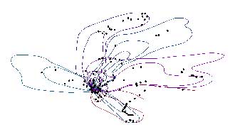
The 2009 eruption of Redoubt Volcano included 19 major tephra-producing explosions. Mass per unit area (MPUA) ash fall sampling of the resulting deposits allowed us to create isomass contours of the ash fall. This dataset contains the vector digital shapefiles of the ash fall contours for the explosive events. In addition, a point digital shapefile is included that describes more than 400 ash fall samples that were collected. For a detailed account of the 2009 eruption of Redoubt Volcano, see Schaefer, J.R., ed., 2012, The 2009 eruption of Redoubt Volcano, Alaska, with contributions by Bull, Katharine, Cameron, Cheryl, Coombs, Michelle, Diefenbach, Angie, Lopez, Taryn, McNutt, Steve, Neal, Christina, Payne, Allison,...
Photograph illustrating the effects of an outburst flood due to volcanic activity: Redoubt Volcano, Chigmit Mountains. Photo shows conditions before eruptions began in January 1966. This large, unnamed glacier shown here descends from the summit crater. Although the glacier is littered by much debris on its lower reaches the spectacular ice cascades on the mountain slopes are almost debris free, indicating recent decades of little volcanic activity. Kenai quadrangle, Spurr district, Cook Inlet region, Alaska. August 1963. Published on sheet 3 in U. S. Geological Survey. Hydrological investigations. Atlas HA-455. 1971.
Categories: Image;
Tags: Glaciers,
Photographers,
Post, A. Collection,
Redoubt volcano,
Spurr district, Cook Inlet region, Alaska,
|

|