Filters: Tags: Water - Oceans and Coasts (X)
6 results (203ms)|
Filters
Date Range
Types Contacts
Categories Tag Types Tag Schemes |
The USGS Topo Large service from The National Map (TNM) is a dynamic topographic base map service that combines the best available data (Boundaries, Elevation, Geographic Names, Hydrography, Land Cover, Structures, Transportation, and other themes) that make up The National Map. Contours generated for the US Topo product are visible along with other data at scales of 1:13,500 and larger. This product is designed to provide a seamless view of the data in a geographic information system (GIS) accessible format, closely resembling The National Map US Topo GeoPDF product at large scales.

USGS Imagery Topo is a topographic tile cache base map with orthoimagery as a backdrop, and combines the most current data (Boundaries, Names, Transportation, Elevation, Hydrography, and other themes) that make up The National Map. Contours generated for the US Topo product are included and are visible along with other data to the 1:18,000 zoom scale. This product is designed to provide a seamless view of the data, closely resembling The National Map's US Topo (GeoPDF) product at large scales, in a GIS accessible format. Orthoimagery data are typically high resolution aerial images that combine the visual attributes of an aerial photograph with the spatial accuracy and reliability of a map. Digital orthoimage resolution...
The website and data server at http://stellwagen.er.usgs.gov/ is a USGS approved database. It provides descriptions of the research programs and access to time series oceanographic data collected by USGS investigators at the Woods Hole Science Center, often in collaboration with others, as part of experiments to study circulation and sediment transport in the coastal ocean. The experiments were carried out between 1975 and present. Measurements include ocean current velocity, wave statistics, temperature, pressure, conductivity, light transmission (beam atttenuation) among others. In some experiments, local meteorolical data was also collected. Data is provided at the fastest instrument sampling interval and...
U.S. Geological Survey, Department of the Interior - The annual National Hydrography Dataset (NHD) stewardship plan is to maintain hydrography data in the NHD over the United States and its territories. NHD for the nation has been collected and is now in maintenance mode. Interested parties who wish to become a NHD stewardship partner with the USGS in FY15 or in future years should contact a USGS Geospatial Liaison - http://liaisons.usgs.gov/geospatial/documents/TNM_Partnership_User_ContactList.pdf. To find out more about hydrography stewardship go to http://nhd.usgs.gov/stewardship.html or for exact project status information on areas currently in work go to http://nhd.usgs.gov/project_status.html
USGS Topo is a topographic tile cache base map that combines the most current data (Boundaries, Names, Transportation, Elevation, Hydrography, Land Cover, and other themes) that make up The National Map. Contours generated for the US Topo product are included and are visible along with other data to the 1:18,000 zoom scale. This product is designed to provide a seamless view of the data, closely resembling The National Map's US Topo (GeoPDF) product at large scales, in a GIS accessible format.

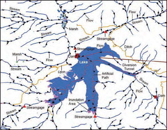
USGS Hydro-NHD is a tile cache base map that combines hydrography data in The National Map from the National Hydrography Dataset (NHD) along with the Watershed Boundary Dataset (WBD). The NHD is a comprehensive set of digital spatial data that encodes information about naturally occurring and constructed bodies of surface water (lakes, ponds, and reservoirs), paths through which water flows (canals, ditches, streams, and rivers), and related entities such as point features (springs, wells, stream gages, and dams). The information encoded about these features includes classification and other characteristics, delineation, geographic name, position and related measures, a "reach code" through which other information...
|

|
